Bridge Statistics for Sunnyslope, Washington (WA)
Condition, Traffic, Stress, Structural Evaluation, Project Costs
- National Bridge Inventory (NBI) Statistics
- 13Number of bridges
- 269ft / 82.4mTotal length
- $81,465,000Total costs
- 196,801Total average daily traffic
- 16,896Total average daily truck traffic
- National Bridge Inventory (NBI) Registered Bridges for Sunnyslope
- No street view available for this location
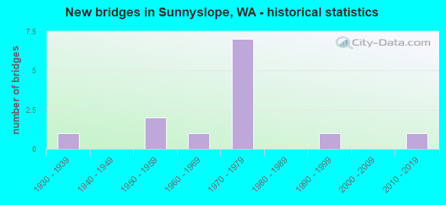
- New bridges - historical statistics
- 11930-1939
- 21950-1959
- 11960-1969
- 71970-1979
- 11990-1999
- 12010-2019


- Bridge Condition - Deck
- 33.3%Very good
- 33.3%Good
- 11.1%Satisfactory
- 11.1%Fair
- 11.1%Poor

- Bridge Condition - Superstructure
- 11.1%Very good
- 66.7%Good
- 11.1%Satisfactory
- 11.1%Fair

- Bridge Condition - Substructure
- 11.1%Very good
- 66.7%Good
- 22.2%Satisfactory
Find on map >> Show street view
Structure Number: 4136A, Location: 14.4 E JCT US 97 (Lat: 47.467389, Lng: -120.338833), Route carried "on" structure: US 2, Year Built: 1952, Year Reconstructed: 1992, Status: Open, Structure Length: 4.36m (14.30ft), Average Daily Traffic: 14,259 (year 2019), Truck Traffic: 7%, Average Future Daily Traffic: 17,909 (year 2039), Design Load: HS 20, Features Intersected: US 2 RAMP
Minimum Vertical Clearance: 30+ m (98+ ft), Kilometerpoint: 191.303, Lanes on structure: 5, Lanes under structure: 2, Base Highway Network: Yes, Owner: State Highway Agency, Approaching Roadway Width: 29.0m (95.1ft), Skew: 31 degrees, Material/Design: Concrete continuous, Design/Construction: Tee Beam, Number Of Spans In Main Unit: 3, Length of Maximum Span: 17.1m (56.1ft), Curb-To-Curb Width: 28.3m (92.8ft), Out-to-Out Width: 29.9m (98.1ft)
Condition: Deck: Satisfactory, Superstructure: Fair, Substructure: Satisfactory, Operating Rating: 33.7 metric tons, Method Used To Determine Operating Rating: Load and Resistance Factor Rating (LRFR) rating reported by rating factor(RF) method using HL-93 loadings, Inventory Rating: 26.2 metric tons, Method Used To Determine Inventory Rating: Load and Resistance Factor Rating (LRFR) rating reported by rating factor(RF) method using HL-93 loadings, Structural Evaluation: Somewhat better than minimum adequacy, Deck Geometry: Superior to present desirable criteria, Underclear: High priority of corrective action, Approach Roadway Alignment: Equal to present desirable criteria, Length Of Structure Improvement: 4.36m (14.30ft), Designated Inspection Frequency: Every 24 months, Inspection Date: August 2021, Bridge Improvement Cost: $2,774,000, Roadway Improvement Cost: $555,000, Total Project Cost: $5,548,000 ( Estimate for 2014), Deck Structure Type: Concrete Cast-file-Place, Wearing Surface/Protective System: Wearing Surface: Bituminous, Membrane: Preformed Fabric, Deck Protection: Epoxy Coated Reinforcing
Find on map >> Show street view
Structure Number: 9102A, Location: 0.3 E JCT US 97 ALT (Lat: 47.471583, Lng: -120.319472), Route carried "on" structure: US 2, Year Built: 1975, Status: Open, Structure Length: 42.67m (139.99ft), Average Daily Traffic: 25,907 (year 2019), Truck Traffic: 9%, Average Future Daily Traffic: 32,539 (year 2039), Design Load: HS 20+Mod, Features Intersected: COLUMBIA RIVER
Minimum Vertical Clearance: 30+ m (98+ ft), Kilometerpoint: 192.751, Lanes on structure: 4, Base Highway Network: Yes, Owner: State Highway Agency, Approaching Roadway Width: 22.6m (74.1ft), Skew: 30 degrees, Navigation Control: Yes ( Vertical Clearance: 12.8m (42.0ft), Horizontal Clearance: 76.2m (250.0ft)), Material/Design: Prestressed concrete continuous, Design/Construction: Box Beam or Girders - Multiple, Number Of Spans In Main Unit: 3, Number Of Approach Spans: 4, Length of Maximum Span: 79.2m (259.8ft), Curb or Sidewalk Widths: Left: 0.0m, Right: 3.0m (9.8ft), Curb-To-Curb Width: 20.1m (65.9ft), Out-to-Out Width: 24.4m (80.1ft)
Condition: Deck: Poor, Superstructure: Good, Substructure: Good, Channel: Very good, Operating Rating: 52.6 metric tons, Method Used To Determine Operating Rating: Load Factor (LF), Inventory Rating: 31.7 metric tons, Method Used To Determine Inventory Rating: Load Factor (LF), Structural Evaluation: Better than present minimum criteria, Deck Geometry: Equal to present minimum criteria, Waterway Adequacy: Equal to present desirable criteria, Approach Roadway Alignment: Equal to present desirable criteria, Length Of Structure Improvement: 42.67m (139.99ft), Designated Inspection Frequency: Every 48 months, Underwater Inspection Frequency: Every 60 months, Inspection Date: July 2018, Underwater Inspection Date: September 2017, Bridge Improvement Cost: $21,280,000, Roadway Improvement Cost: $4,256,000, Total Project Cost: $42,560,000 ( Estimate for 2014), Deck Structure Type: Concrete Cast-file-Place, Wearing Surface/Protective System: Wearing Surface: Bituminous, Membrane: Preformed Fabric
Find on map >> Show street view
Structure Number: 9683A, Location: 0.2 E JCT US 97 ALT (Lat: 47.471889, Lng: -120.321500), Route carried "on" structure: US 2, Year Built: 1974, Status: Open, Structure Length: 5.58m (18.31ft), Average Daily Traffic: 22,654 (year 2019), Truck Traffic: 9%, Average Future Daily Traffic: 28,453 (year 2039), Design Load: HS 20+Mod, Features Intersected: BN RR
Minimum Vertical Clearance: 30+ m (98+ ft), Kilometerpoint: 192.606, Lanes on structure: 5, Base Highway Network: Yes, Owner: State Highway Agency, Approaching Roadway Width: 28.3m (92.8ft), Skew: 30 degrees, Material/Design: Prestressed concrete continuous, Design/Construction: Stringer/Multi-beam, Number Of Spans In Main Unit: 3, Length of Maximum Span: 18.6m (61.0ft), Curb-To-Curb Width: 28.0m (91.9ft), Out-to-Out Width: 29.0m (95.1ft)
Condition: Deck: Good, Superstructure: Good, Substructure: Good, Operating Rating: 45.4 metric tons, Method Used To Determine Operating Rating: Load Factor (LF), Inventory Rating: 27.2 metric tons, Method Used To Determine Inventory Rating: Load Factor (LF), Structural Evaluation: Equal to present minimum criteria, Deck Geometry: Superior to present desirable criteria, Underclear: Superior to present desirable criteria, Approach Roadway Alignment: Equal to present desirable criteria, Length Of Structure Improvement: 5.58m (18.31ft), Designated Inspection Frequency: Every 48 months, Inspection Date: July 2018, Bridge Improvement Cost: $3,477,000, Roadway Improvement Cost: $695,000, Total Project Cost: $6,954,000 ( Estimate for 2014), Deck Structure Type: Concrete Cast-file-Place, Wearing Surface/Protective System: Wearing Surface: Bituminous, Membrane: Preformed Fabric
Find on map >> Show street view
Structure Number: 9683C, Location: 0.8 E JCT US 97 ALT (Lat: 47.470272, Lng: -120.308097), Route carried "on" structure: US 2, Year Built: 1974, Status: Open, Structure Length: 3.96m (12.99ft), Average Daily Traffic: 25,907 (year 2019), Truck Traffic: 9%, Average Future Daily Traffic: 32,124 (year 2039), Design Load: HS 20+Mod, Features Intersected: DRY WASH
Minimum Vertical Clearance: 30+ m (98+ ft), Kilometerpoint: 193.636, Lanes on structure: 4, Base Highway Network: Yes, Owner: State Highway Agency, Approaching Roadway Width: 21.3m (69.9ft), Skew: 30 degrees, Material/Design: Prestressed concrete, Design/Construction: Stringer/Multi-beam, Number Of Spans In Main Unit: 1, Length of Maximum Span: 38.1m (125.0ft), Curb-To-Curb Width: 21.3m (69.9ft), Out-to-Out Width: 22.9m (75.1ft)
Condition: Deck: Good, Superstructure: Good, Substructure: Good, Operating Rating: 24.9 metric tons, Method Used To Determine Operating Rating: Load and Resistance Factor Rating (LRFR) rating reported by rating factor(RF) method using HL-93 loadings, Inventory Rating: 19.1 metric tons, Method Used To Determine Inventory Rating: Load and Resistance Factor Rating (LRFR) rating reported by rating factor(RF) method using HL-93 loadings, Structural Evaluation: Meets minimum limits, Deck Geometry: Better than present minimum criteria, Approach Roadway Alignment: Equal to present desirable criteria, Length Of Structure Improvement: 3.96m (12.99ft), Designated Inspection Frequency: Every 24 months, Inspection Date: August 2021, Bridge Improvement Cost: $1,872,000, Roadway Improvement Cost: $374,000, Total Project Cost: $3,744,000 ( Estimate for 2014), Deck Structure Type: Concrete Cast-file-Place, Wearing Surface/Protective System: Wearing Surface: Bituminous, Membrane: Preformed Fabric
Find on map >> Show street view
Structure Number: 10839A, Location: JCT US 97 ALT (Lat: 47.472139, Lng: -120.325111), Route carried "on" structure: US 2, Year Built: 1979, Status: Open, Structure Length: 4.82m (15.81ft), Average Daily Traffic: 11,327 (year 2019), Truck Traffic: 9%, Average Future Daily Traffic: 14,226 (year 2039), Design Load: HS 20+Mod, Features Intersected: US 97 ALT, EUCLID AVE
Minimum Vertical Clearance: 30+ m (98+ ft), Kilometerpoint: 192.574, Lanes on structure: 3, Lanes under structure: 4, Base Highway Network: Yes, Owner: State Highway Agency, Approaching Roadway Width: 15.2m (49.9ft), Material/Design: Prestressed concrete, Design/Construction: Box Beam or Girders - Multiple, Number Of Spans In Main Unit: 1, Length of Maximum Span: 47.9m (157.2ft), Curb-To-Curb Width: 15.2m (49.9ft), Out-to-Out Width: 16.2m (53.1ft)
Condition: Deck: Very good, Superstructure: Good, Substructure: Good, Operating Rating: 89.8 metric tons, Method Used To Determine Operating Rating: Load Factor (LF), Inventory Rating: 87.1 metric tons, Method Used To Determine Inventory Rating: Load Factor (LF), Structural Evaluation: Better than present minimum criteria, Deck Geometry: Meets minimum limits, Underclear: Somewhat better than minimum adequacy, Approach Roadway Alignment: Equal to present desirable criteria, Length Of Structure Improvement: 4.82m (15.81ft), Designated Inspection Frequency: Every 24 months, Inspection Date: August 2021, Bridge Improvement Cost: $1,643,000, Roadway Improvement Cost: $329,000, Total Project Cost: $3,286,000 ( Estimate for 2014), Deck Structure Type: Concrete Cast-file-Place, Wearing Surface/Protective System: Wearing Surface: Bituminous, Membrane: Preformed Fabric
Find on map >> Show street view
Structure Number: 10839B, Location: JCT US 97 ALT (Lat: 47.472306, Lng: -120.325111), Route carried "on" structure: US 2, Year Built: 1979, Status: Open, Structure Length: 4.82m (15.81ft), Average Daily Traffic: 11,327 (year 2019), Truck Traffic: 9%, Average Future Daily Traffic: 14,226 (year 2039), Design Load: HS 20+Mod, Features Intersected: US 97 ALT, EUCLID AVE
Minimum Vertical Clearance: 30+ m (98+ ft), Kilometerpoint: 192.574, Lanes on structure: 2, Lanes under structure: 4, Base Highway Network: Yes, Owner: State Highway Agency, Approaching Roadway Width: 12.2m (40.0ft), Material/Design: Prestressed concrete, Design/Construction: Box Beam or Girders - Multiple, Number Of Spans In Main Unit: 1, Length of Maximum Span: 48.2m (158.1ft), Curb-To-Curb Width: 11.6m (38.1ft), Out-to-Out Width: 12.5m (41.0ft)
Condition: Deck: Very good, Superstructure: Good, Substructure: Good, Operating Rating: 89.8 metric tons, Method Used To Determine Operating Rating: Load Factor (LF), Inventory Rating: 68.9 metric tons, Method Used To Determine Inventory Rating: Load Factor (LF), Structural Evaluation: Better than present minimum criteria, Deck Geometry: Equal to present minimum criteria, Underclear: Better than present minimum criteria, Approach Roadway Alignment: Equal to present desirable criteria, Length Of Structure Improvement: 4.82m (15.81ft), Designated Inspection Frequency: Every 24 months, Inspection Date: August 2021, Bridge Improvement Cost: $1,327,000, Roadway Improvement Cost: $265,000, Total Project Cost: $2,654,000 ( Estimate for 2014), Deck Structure Type: Concrete Cast-file-Place, Wearing Surface/Protective System: Wearing Surface: Bituminous, Membrane: Preformed Fabric
Find on map >> Show street view
Structure Number: 14723A, Location: 4.9 N JCT SR 28 (Lat: 47.465194, Lng: -120.336806), Route carried "on" structure: State highway 285, Year Built: 1996, Status: Open, Structure Length: 3.75m (12.30ft), Average Daily Traffic: 27,674 (year 2019), Truck Traffic: 7%, Average Future Daily Traffic: 34,758 (year 2039), Design Load: HS 25 or greater, Features Intersected: PENNY RD
Minimum Vertical Clearance: 30+ m (98+ ft), Kilometerpoint: 7.870, Lanes on structure: 5, Lanes under structure: 3, Base Highway Network: Yes, Owner: State Highway Agency, Approaching Roadway Width: 29.0m (95.1ft), Skew: 31 degrees, Material/Design: Prestressed concrete, Design/Construction: Stringer/Multi-beam, Number Of Spans In Main Unit: 1, Length of Maximum Span: 36.0m (118.1ft), Curb-To-Curb Width: 28.9m (94.8ft), Out-to-Out Width: 32.0m (105.0ft)
Condition: Deck: Good, Superstructure: Good, Substructure: Good, Operating Rating: 89.8 metric tons, Method Used To Determine Operating Rating: Load Factor (LF), Inventory Rating: 36.3 metric tons, Method Used To Determine Inventory Rating: Load Factor (LF), Structural Evaluation: Better than present minimum criteria, Deck Geometry: Superior to present desirable criteria, Underclear: Meets minimum limits, Approach Roadway Alignment: Equal to present desirable criteria, Length Of Structure Improvement: 3.75m (12.30ft), Designated Inspection Frequency: Every 24 months, Inspection Date: August 2021, Bridge Improvement Cost: $2,386,000, Roadway Improvement Cost: $477,000, Total Project Cost: $4,772,000 ( Estimate for 2014), Deck Structure Type: Concrete Cast-file-Place, Wearing Surface/Protective System: Wearing Surface: Monolithic Concrete, Deck Protection: Epoxy Coated Reinforcing
Find on map >> Show street view
Structure Number: 81736, Location: 00.07W SR 97 (Lat: 47.487083, Lng: -120.414889), Route carried "on" structure: County highway 94200, Year Built: 1930, Status: Open, Structure Length: 10.88m (35.70ft), Average Daily Traffic: 1,857 (year 2020), Truck Traffic: 4%, Average Future Daily Traffic: 2,385 (year 2040), Design Load: H 15, Features Intersected: WENATCHEE RIVER, Facility Carried by Structure: OLD MONITOR ROAD
Minimum Vertical Clearance: 30+ m (98+ ft), Kilometerpoint: 0.001, Lanes on structure: 2, Owner: County Highway Agency, Approaching Roadway Width: 8.5m (27.9ft), Skew: 2 degrees, Material/Design: Concrete continuous, Design/Construction: Arch - Deck, Number Of Spans In Main Unit: 3, Number Of Approach Spans: 1, Length of Maximum Span: 39.9m (130.9ft), Curb or Sidewalk Widths: Left: 1.2m (3.9ft), Right: 1.2m (3.9ft), Curb-To-Curb Width: 6.1m (20.0ft), Out-to-Out Width: 9.4m (30.8ft)
Condition: Deck: Fair, Superstructure: Satisfactory, Substructure: Satisfactory, Channel: Very good, Operating Rating: 29.2 metric tons, Method Used To Determine Operating Rating: Load and Resistance Factor Rating (LRFR) rating reported by rating factor(RF) method using HL-93 loadings, Inventory Rating: 22.4 metric tons, Method Used To Determine Inventory Rating: Load and Resistance Factor Rating (LRFR) rating reported by rating factor(RF) method using HL-93 loadings, Structural Evaluation: Somewhat better than minimum adequacy, Deck Geometry: High priority of replacement, Waterway Adequacy: Equal to present minimum criteria, Approach Roadway Alignment: Equal to present desirable criteria, Length Of Structure Improvement: 11.19m (36.71ft), Designated Inspection Frequency: Every 24 months, Underwater Inspection Frequency: Every 60 months, Inspection Date: August 2021, Underwater Inspection Date: August 2021, Bridge Improvement Cost: $5,578,000, Roadway Improvement Cost: $1,116,000, Total Project Cost: $11,157,000 ( Estimate for 2014), Deck Structure Type: Concrete Cast-file-Place, Wearing Surface/Protective System: Wearing Surface: Monolithic Concrete
Find on map >> Show street view
Structure Number: 88283, Location: W OF J.M. DICKENSON (Lat: 47.439897, Lng: -122.736075), Route carried "on" structure: County highway 21320, Year Built: 2011, Status: Open, Structure Length: 1.58m (5.18ft), Average Daily Traffic: 1,256 (year 2020), Truck Traffic: 16%, Average Future Daily Traffic: 1,382 (year 2042), Design Load: HL 93, Features Intersected: MUCK FORK CREEK, Facility Carried by Structure: LAKE HELENA RD SW
Minimum Vertical Clearance: 30+ m (98+ ft), Kilometerpoint: 0.001, Lanes on structure: 2, Owner: County Highway Agency, Approaching Roadway Width: 11.0m (36.1ft), Material/Design: Prestressed concrete continuous, Design/Construction: Slab, Number Of Spans In Main Unit: 1, Length of Maximum Span: 15.2m (49.9ft), Curb-To-Curb Width: 10.8m (35.4ft), Out-to-Out Width: 11.0m (36.1ft)
Condition: Deck: Very good, Superstructure: Very good, Substructure: Very good, Channel: Very good, Operating Rating: 70.0 metric tons, Method Used To Determine Operating Rating: Load and Resistance Factor Rating (LRFR) rating reported by rating factor(RF) method using HL-93 loadings, Inventory Rating: 54.1 metric tons, Method Used To Determine Inventory Rating: Load and Resistance Factor Rating (LRFR) rating reported by rating factor(RF) method using HL-93 loadings, Structural Evaluation: Equal to present desirable criteria, Deck Geometry: Equal to present minimum criteria, Waterway Adequacy: Equal to present desirable criteria, Approach Roadway Alignment: Equal to present desirable criteria, Length Of Structure Improvement: 1.58m (5.18ft), Designated Inspection Frequency: Every 24 months, Inspection Date: July 2021, Bridge Improvement Cost: $395,000, Roadway Improvement Cost: $79,000, Total Project Cost: $790,000 ( Estimate for 2014), Deck Structure Type: Concrete Precast Panels, Wearing Surface/Protective System: Wearing Surface: Bituminous, Membrane: Preformed Fabric, Deck Protection: Epoxy Coated Reinforcing
Find on map >> Show street view
Structure Number: 4136A, Location: 14.4 E JCT US 97 (Lat: 47.467389, Lng: -120.338833), Route carried "under" structure: US 2, Year Built: 1952, Structure Length: 0. m, Average Daily Traffic: 13,906 (year 2019), Truck Traffic: 9%, Features Intersected: US 2 RAMP
Minimum Vertical Clearance: 4.78m (15.68ft), Kilometerpoint: 191.383, Lanes on structure: 5, Lanes under structure: 2, Material/Design: Concrete continuous, Design/Construction: Tee Beam, Length of Maximum Span: 17.1m (56.1ft)
Find on map >> Show street view
Structure Number: 7721A, Location: 10.7 E JCT US 97 (Lat: 47.486806, Lng: -120.411917), Route carried "under" structure: US 2, Year Built: 1965, Structure Length: 0. m, Average Daily Traffic: 23,753 (year 2019), Truck Traffic: 7%, Features Intersected: US 2, Facility Carried by Structure: PEDESTRIANS
Minimum Vertical Clearance: 6.55m (21.49ft), Kilometerpoint: 185.364, Lanes under structure: 6, Material/Design: Prestressed concrete, Design/Construction: Slab, Length of Maximum Span: 21.3m (69.9ft)
Find on map >> Show street view
Structure Number: 10839A, Location: JCT US 2 (Lat: 47.472139, Lng: -120.325111), Route carried "under" structure: Alternate US 97, Year Built: 1979, Structure Length: 0. m, Average Daily Traffic: 8,487 (year 2019), Truck Traffic: 12%, Features Intersected: US 97 ALT, EUCLID AVE, Facility Carried by Structure: US 2
Minimum Vertical Clearance: 5.16m (16.93ft), Kilometerpoint: 321.595, Lanes on structure: 3, Lanes under structure: 2, Material/Design: Prestressed concrete, Design/Construction: Box Beam or Girders - Multiple, Length of Maximum Span: 47.9m (157.2ft)
Find on map >> Show street view
Structure Number: 10839B, Location: JCT US 2 (Lat: 47.472306, Lng: -120.325111), Route carried "under" structure: Alternate US 97, Year Built: 1979, Structure Length: 0. m, Average Daily Traffic: 8,487 (year 2019), Truck Traffic: 12%, Features Intersected: US 97 ALT, EUCLID AVE, Facility Carried by Structure: US 2
Minimum Vertical Clearance: 6.27m (20.57ft), Kilometerpoint: 321.611, Lanes on structure: 2, Lanes under structure: 2, Material/Design: Prestressed concrete, Design/Construction: Box Beam or Girders - Multiple, Length of Maximum Span: 48.2m (158.1ft)