Bridge Statistics for Sunriver, Oregon (OR)
Condition, Traffic, Stress, Structural Evaluation, Project Costs
- National Bridge Inventory (NBI) Statistics
- 13Number of bridges
- 72ft / 22.2mTotal length
- $661,000Total costs
- 58,546Total average daily traffic
- 4,695Total average daily truck traffic
- National Bridge Inventory (NBI) Registered Bridges for Sunriver
- No street view available for this location
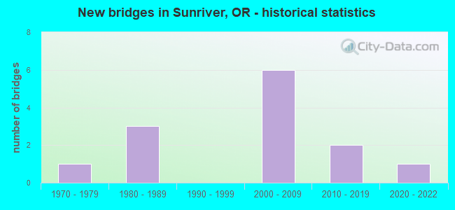
- New bridges - historical statistics
- 11970-1979
- 31980-1989
- 62000-2009
- 22010-2019
- 12020-2022


- Bridge Condition - Deck
- 11.1%Very good
- 77.8%Good
- 11.1%Satisfactory

- Bridge Condition - Superstructure
- 55.6%Very good
- 22.2%Good
- 11.1%Satisfactory
- 11.1%Fair

- Bridge Condition - Substructure
- 66.7%Very good
- 22.2%Good
- 11.1%Fair
Find on map >> Show street view
Structure Number: 16181 E20 02685, Location: 0100 MI W HWY 97 (Lat: 43.869400, Lng: -121.430111), Route carried "on" structure: County highway 4112, Year Built: 1976, Status: Open, Structure Length: 3.93m (12.89ft), Average Daily Traffic: 8,558 (year 2020), Truck Traffic: 2%, Average Future Daily Traffic: 10,000 (year 2030), Design Load: HS 20, Features Intersected: BURLINGTON N. R.R., Facility Carried by Structure: S CENTURY DR
Minimum Vertical Clearance: 30+ m (98+ ft), Kilometerpoint: 2.099, Lanes on structure: 2, Owner: County Highway Agency, Approaching Roadway Width: 12.2m (40.0ft), Material/Design: Prestressed concrete, Design/Construction: Slab, Number Of Spans In Main Unit: 3, Length of Maximum Span: 15.2m (49.9ft), Curb or Sidewalk Widths: Left: 1.8m (5.9ft), Right: 1.8m (5.9ft), Curb-To-Curb Width: 12.2m (40.0ft), Out-to-Out Width: 17.1m (56.1ft)
Condition: Deck: Satisfactory, Superstructure: Fair, Substructure: Fair, Operating Rating: 37.6 metric tons, Method Used To Determine Operating Rating: Load and Resistance Factor Rating (LRFR) rating reported by rating factor(RF) method using HL-93 loadings, Inventory Rating: 28.8 metric tons, Method Used To Determine Inventory Rating: Load and Resistance Factor Rating (LRFR) rating reported by rating factor(RF) method using HL-93 loadings, Structural Evaluation: Somewhat better than minimum adequacy, Deck Geometry: Somewhat better than minimum adequacy, Underclear: High priority of corrective action, Approach Roadway Alignment: Equal to present desirable criteria, Length Of Structure Improvement: 3.90m (12.80ft), Designated Inspection Frequency: Every 24 months, Inspection Date: March 2020, Bridge Improvement Cost: $413,000, Roadway Improvement Cost: $41,000, Total Project Cost: $661,000, Deck Structure Type: Concrete Cast-file-Place, Wearing Surface/Protective System: Wearing Surface: Integral Concrete
Find on map >> Show street view
Structure Number: 16712 004 15133, Location: 017 MI SO LAVA LANDS CTR (Lat: 43.889689, Lng: -121.381222), Route carried "on" structure: US 97, Year Built: 1984, Status: Open, Structure Length: 1.49m (4.89ft), Average Daily Traffic: 5,730 (year 2020), Truck Traffic: 11%, Average Future Daily Traffic: 8,250 (year 2040), Design Load: HS 20, Features Intersected: COTTONWOOD RD
Minimum Vertical Clearance: 30+ m (98+ ft), Kilometerpoint: 243.494, Lanes on structure: 2, Lanes under structure: 2, Base Highway Network: Yes, Owner: State Highway Agency, Approaching Roadway Width: 9.8m (32.2ft), Material/Design: Prestressed concrete, Design/Construction: Slab, Number Of Spans In Main Unit: 1, Length of Maximum Span: 14.9m (48.9ft), Curb-To-Curb Width: 11.8m (38.7ft), Out-to-Out Width: 13.4m (44.0ft)
Condition: Deck: Good, Superstructure: Good, Substructure: Good, Operating Rating: 39.5 metric tons, Method Used To Determine Operating Rating: Load and Resistance Factor Rating (LRFR) rating reported by rating factor(RF) method using HL-93 loadings, Inventory Rating: 30.5 metric tons, Method Used To Determine Inventory Rating: Load and Resistance Factor Rating (LRFR) rating reported by rating factor(RF) method using HL-93 loadings, Structural Evaluation: Better than present minimum criteria, Deck Geometry: Better than present minimum criteria, Underclear: Somewhat better than minimum adequacy, Approach Roadway Alignment: Equal to present desirable criteria, Designated Inspection Frequency: Every 24 months, Inspection Date: Febuary 2021, Deck Structure Type: Concrete Cast-file-Place, Wearing Surface/Protective System: Wearing Surface: Bituminous, Membrane: Preformed Fabric, Deck Protection: Epoxy Coated Reinforcing
Find on map >> Show street view
Structure Number: 17C550E1560019, Location: 0190 MI WEST HWY 97 (Lat: 43.893669, Lng: -121.415639), Route carried "on" structure: County highway 4143, Year Built: 1984, Status: Open, Structure Length: 4.27m (14.01ft), Average Daily Traffic: 5,280 (year 2020), Truck Traffic: 2%, Average Future Daily Traffic: 6,857 (year 2025), Design Load: HS 20, Features Intersected: B N R R O-XING, Facility Carried by Structure: COTTONWOOD
Minimum Vertical Clearance: 30+ m (98+ ft), Kilometerpoint: 4.329, Lanes on structure: 2, Owner: County Highway Agency, Approaching Roadway Width: 10.4m (34.1ft), Material/Design: Prestressed concrete, Design/Construction: Slab, Number Of Spans In Main Unit: 3, Length of Maximum Span: 14.0m (45.9ft), Curb-To-Curb Width: 11.1m (36.4ft), Out-to-Out Width: 12.2m (40.0ft)
Condition: Deck: Good, Superstructure: Satisfactory, Substructure: Good, Operating Rating: 55.3 metric tons, Method Used To Determine Operating Rating: Load Factor (LF), Inventory Rating: 32.7 metric tons, Method Used To Determine Inventory Rating: Load Factor (LF), Structural Evaluation: Equal to present minimum criteria, Deck Geometry: Meets minimum limits, Underclear: Better than present minimum criteria, Approach Roadway Alignment: Equal to present desirable criteria, Designated Inspection Frequency: Every 24 months, Inspection Date: March 2020, Deck Structure Type: Other, Wearing Surface/Protective System: Wearing Surface: Bituminous
Find on map >> Show street view
Structure Number: 20206 004 15305, Location: SUNRIVER (Lat: 43.869539, Lng: -121.402700), Route carried "on" structure: US 97, Year Built: 2006, Status: Open, Structure Length: 2.62m (8.60ft), Average Daily Traffic: 5,730 (year 2020), Truck Traffic: 11%, Average Future Daily Traffic: 8,250 (year 2040), Design Load: HL 93, Features Intersected: S. CENTURY DR.
Minimum Vertical Clearance: 30+ m (98+ ft), Kilometerpoint: 246.310, Lanes on structure: 2, Lanes under structure: 2, Base Highway Network: Yes, Owner: State Highway Agency, Approaching Roadway Width: 14.6m (47.9ft), Material/Design: Prestressed concrete, Design/Construction: Slab, Number Of Spans In Main Unit: 1, Length of Maximum Span: 26.2m (86.0ft), Curb-To-Curb Width: 13.8m (45.3ft), Out-to-Out Width: 14.6m (47.9ft)
Condition: Deck: Good, Superstructure: Very good, Substructure: Very good, Operating Rating: 66.4 metric tons, Method Used To Determine Operating Rating: Load and Resistance Factor Rating (LRFR) rating reported by rating factor(RF) method using HL-93 loadings, Inventory Rating: 51.2 metric tons, Method Used To Determine Inventory Rating: Load and Resistance Factor Rating (LRFR) rating reported by rating factor(RF) method using HL-93 loadings, Structural Evaluation: Equal to present desirable criteria, Deck Geometry: Superior to present desirable criteria, Underclear: Superior to present desirable criteria, Approach Roadway Alignment: Equal to present desirable criteria, Designated Inspection Frequency: Every 24 months, Inspection Date: November 2020, Deck Structure Type: Concrete Cast-file-Place, Wearing Surface/Protective System: Wearing Surface: Epoxy Overlay, Deck Protection: Epoxy Coated Reinforcing
Find on map >> Show street view
Structure Number: 20207 004 15308, Location: SUNRIVER (Lat: 43.869700, Lng: -121.403419), Route carried "on" structure: US 97, Year Built: 2005, Status: Open, Structure Length: 2.62m (8.60ft), Average Daily Traffic: 5,730 (year 2020), Truck Traffic: 11%, Average Future Daily Traffic: 8,250 (year 2040), Design Load: HL 93, Features Intersected: S. CENTURY DRIVE
Minimum Vertical Clearance: 30+ m (98+ ft), Kilometerpoint: 246.358, Lanes on structure: 2, Lanes under structure: 2, Base Highway Network: Yes, Owner: State Highway Agency, Approaching Roadway Width: 14.6m (47.9ft), Material/Design: Prestressed concrete, Design/Construction: Slab, Number Of Spans In Main Unit: 1, Length of Maximum Span: 26.2m (86.0ft), Curb-To-Curb Width: 13.8m (45.3ft), Out-to-Out Width: 14.6m (47.9ft)
Condition: Deck: Good, Superstructure: Good, Substructure: Very good, Operating Rating: 68.0 metric tons, Method Used To Determine Operating Rating: Load and Resistance Factor Rating (LRFR) rating reported by rating factor(RF) method using HL-93 loadings, Inventory Rating: 52.5 metric tons, Method Used To Determine Inventory Rating: Load and Resistance Factor Rating (LRFR) rating reported by rating factor(RF) method using HL-93 loadings, Structural Evaluation: Better than present minimum criteria, Deck Geometry: Superior to present desirable criteria, Underclear: Superior to present desirable criteria, Approach Roadway Alignment: Equal to present desirable criteria, Designated Inspection Frequency: Every 24 months, Inspection Date: November 2020, Deck Structure Type: Concrete Cast-file-Place, Wearing Surface/Protective System: Wearing Surface: Epoxy Overlay, Deck Protection: Epoxy Coated Reinforcing
Find on map >> Show street view
Structure Number: 20552 004 1513, Location: HWY 004 NB AT MP 151.30 (Lat: 43.889300, Lng: -121.380600), Route carried "on" structure: US 97, Year Built: 2009, Status: Open, Structure Length: 1.98m (6.50ft), Average Daily Traffic: 5,730 (year 2020), Truck Traffic: 11%, Average Future Daily Traffic: 8,250 (year 2040), Design Load: HL 93, Features Intersected: COTTONWOOD RD
Minimum Vertical Clearance: 30+ m (98+ ft), Kilometerpoint: 243.494, Lanes on structure: 2, Lanes under structure: 2, Base Highway Network: Yes, Owner: State Highway Agency, Approaching Roadway Width: 12.5m (41.0ft), Material/Design: Prestressed concrete, Design/Construction: Slab, Number Of Spans In Main Unit: 1, Length of Maximum Span: 19.2m (63.0ft), Curb-To-Curb Width: 12.5m (41.0ft), Out-to-Out Width: 13.4m (44.0ft)
Condition: Deck: Good, Superstructure: Very good, Substructure: Very good, Operating Rating: 89.7 metric tons, Method Used To Determine Operating Rating: Load and Resistance Factor Rating (LRFR) rating reported by rating factor(RF) method using HL-93 loadings, Inventory Rating: 69.0 metric tons, Method Used To Determine Inventory Rating: Load and Resistance Factor Rating (LRFR) rating reported by rating factor(RF) method using HL-93 loadings, Structural Evaluation: Equal to present desirable criteria, Deck Geometry: Better than present minimum criteria, Underclear: Equal to present minimum criteria, Approach Roadway Alignment: Equal to present desirable criteria, Designated Inspection Frequency: Every 24 months, Inspection Date: Febuary 2021, Deck Structure Type: Other, Wearing Surface/Protective System: Wearing Surface: Epoxy Overlay, Deck Protection: Epoxy Coated Reinforcing
Find on map >> Show street view
Structure Number: 21014 004 152, Location: Hwy 004 NB at MP 152.00 (Lat: 43.882100, Lng: -121.391500), Route carried "on" structure: US 97, Year Built: 2011, Status: Open, Structure Length: 1.58m (5.18ft), Average Daily Traffic: 5,730 (year 2020), Truck Traffic: 11%, Average Future Daily Traffic: 8,250 (year 2040), Design Load: HL 93, Features Intersected: Wildlife Passage
Minimum Vertical Clearance: 30+ m (98+ ft), Kilometerpoint: 244.620, Lanes on structure: 2, Base Highway Network: Yes, Owner: State Highway Agency, Approaching Roadway Width: 12.5m (41.0ft), Material/Design: Prestressed concrete, Design/Construction: Slab, Number Of Spans In Main Unit: 1, Length of Maximum Span: 15.8m (51.8ft), Curb-To-Curb Width: 12.5m (41.0ft), Out-to-Out Width: 13.4m (44.0ft)
Condition: Deck: Good, Superstructure: Very good, Substructure: Very good, Operating Rating: 89.7 metric tons, Method Used To Determine Operating Rating: Load and Resistance Factor Rating (LRFR) rating reported by rating factor(RF) method using HL-93 loadings, Inventory Rating: 69.0 metric tons, Method Used To Determine Inventory Rating: Load and Resistance Factor Rating (LRFR) rating reported by rating factor(RF) method using HL-93 loadings, Structural Evaluation: Equal to present desirable criteria, Deck Geometry: Better than present minimum criteria, Approach Roadway Alignment: Equal to present desirable criteria, Designated Inspection Frequency: Every 24 months, Inspection Date: Febuary 2021, Deck Structure Type: Concrete Cast-file-Place, Wearing Surface/Protective System: Wearing Surface: Epoxy Overlay, Deck Protection: Epoxy Coated Reinforcing
Find on map >> Show street view
Structure Number: 21017 004 152, Location: Hwy 004 NB at MP 152.00 (Lat: 43.881700, Lng: -121.390900), Route carried "on" structure: US 97, Year Built: 2010, Status: Open, Structure Length: 1.58m (5.18ft), Average Daily Traffic: 5,730 (year 2020), Truck Traffic: 11%, Average Future Daily Traffic: 8,250 (year 2040), Design Load: HL 93, Features Intersected: Wildlife Passage
Minimum Vertical Clearance: 30+ m (98+ ft), Kilometerpoint: 244.620, Lanes on structure: 2, Base Highway Network: Yes, Owner: State Highway Agency, Approaching Roadway Width: 12.5m (41.0ft), Material/Design: Prestressed concrete, Design/Construction: Slab, Number Of Spans In Main Unit: 1, Length of Maximum Span: 15.8m (51.8ft), Curb-To-Curb Width: 12.5m (41.0ft), Out-to-Out Width: 13.4m (44.0ft)
Condition: Deck: Good, Superstructure: Very good, Substructure: Very good, Operating Rating: 89.7 metric tons, Method Used To Determine Operating Rating: Load and Resistance Factor Rating (LRFR) rating reported by rating factor(RF) method using HL-93 loadings, Inventory Rating: 69.0 metric tons, Method Used To Determine Inventory Rating: Load and Resistance Factor Rating (LRFR) rating reported by rating factor(RF) method using HL-93 loadings, Structural Evaluation: Equal to present desirable criteria, Deck Geometry: Better than present minimum criteria, Approach Roadway Alignment: Equal to present desirable criteria, Designated Inspection Frequency: Every 24 months, Inspection Date: Febuary 2021, Deck Structure Type: Other, Wearing Surface/Protective System: Wearing Surface: Epoxy Overlay, Deck Protection: Epoxy Coated Reinforcing
Find on map >> Show street view
Structure Number: 23931 004 15433, Location: Hwy 004 NB at MP 152.00 (Lat: 43.853733, Lng: -121.414392), Route carried "on" structure: US 97, Year Built: 2021, Status: Open, Structure Length: 2.15m (7.05ft), Average Daily Traffic: 5,268 (year 2020), Truck Traffic: 11%, Average Future Daily Traffic: 7,550 (year 2040), Design Load: HL 93, Features Intersected: Wildlife Passage
Minimum Vertical Clearance: 30+ m (98+ ft), Kilometerpoint: 248.370, Lanes on structure: 2, Base Highway Network: Yes, Owner: State Highway Agency, Approaching Roadway Width: 11.6m (38.1ft), Material/Design: Prestressed concrete, Design/Construction: Slab, Number Of Spans In Main Unit: 1, Length of Maximum Span: 20.4m (66.9ft), Curb-To-Curb Width: 11.6m (38.1ft), Out-to-Out Width: 12.5m (41.0ft)
Condition: Deck: Very good, Superstructure: Very good, Substructure: Very good, Channel: Very good, Operating Rating: 68.0 metric tons, Method Used To Determine Operating Rating: No rating analysis performed, Inventory Rating: 40.8 metric tons, Method Used To Determine Inventory Rating: No rating analysis performed, Structural Evaluation: Equal to present desirable criteria, Deck Geometry: Better than present minimum criteria, Approach Roadway Alignment: Equal to present desirable criteria, Designated Inspection Frequency: Every 24 months, Inspection Date: August 2021, Deck Structure Type: Concrete Cast-file-Place, Wearing Surface/Protective System: Wearing Surface: Monolithic Concrete, Deck Protection: Epoxy Coated Reinforcing
Find on map >> Show street view
Structure Number: 16712 004 15133, Location: 017 MI SO LAVA LANDS CTR (Lat: 43.889689, Lng: -121.381222), Route carried "under" structure: County highway , Year Built: 1984, Structure Length: 0. m, Average Daily Traffic: 1,000 (year 2010), Truck Traffic: 1%, Features Intersected: COTTONWOOD RD, Facility Carried by Structure: US 97 (HWY 004) SB
Minimum Vertical Clearance: 4.52m (14.83ft), Kilometerpoint: 0.000, Lanes on structure: 2, Lanes under structure: 2, Material/Design: Prestressed concrete, Design/Construction: Slab, Length of Maximum Span: 14.9m (48.9ft)
Find on map >> Show street view
Structure Number: 20206 004 15305, Location: SUNRIVER (Lat: 43.869539, Lng: -121.402700), Route carried "under" structure: City street , Year Built: 2006, Structure Length: 0. m, Average Daily Traffic: 2,060 (year 2010), Truck Traffic: 1%, Features Intersected: S. CENTURY DR., Facility Carried by Structure: US 97 (HWY 004) NB
Minimum Vertical Clearance: 5.18m (16.99ft), Kilometerpoint: 0.000, Lanes on structure: 2, Lanes under structure: 2, Material/Design: Prestressed concrete, Design/Construction: Slab, Length of Maximum Span: 26.2m (86.0ft)
Find on map >> Show street view
Structure Number: 20207 004 15308, Location: SUNRIVER (Lat: 43.869700, Lng: -121.403419), Route carried "under" structure: City street , Year Built: 2005, Structure Length: 0. m, Average Daily Traffic: 1,000 (year 2010), Truck Traffic: 2%, Features Intersected: S. CENTURY DRIVE, Facility Carried by Structure: US 97 (HWY 004) SB
Minimum Vertical Clearance: 5.18m (16.99ft), Kilometerpoint: 0.000, Lanes on structure: 2, Lanes under structure: 2, Material/Design: Prestressed concrete, Design/Construction: Slab, Length of Maximum Span: 26.2m (86.0ft)
Find on map >> Show street view
Structure Number: 20552 004 1513, Location: HWY 004 NB AT MP 151.30 (Lat: 43.889300, Lng: -121.380600), Route carried "under" structure: County highway , Year Built: 2009, Structure Length: 0. m, Average Daily Traffic: 1,000 (year 2010), Truck Traffic: 1%, Features Intersected: COTTONWOOD RD, Facility Carried by Structure: US 97 (HWY 004) NB
Minimum Vertical Clearance: 4.47m (14.67ft), Kilometerpoint: 0.000, Lanes on structure: 2, Lanes under structure: 2, Material/Design: Prestressed concrete, Design/Construction: Slab, Length of Maximum Span: 19.2m (63.0ft)