Bridge Statistics for Sunset Hills, Missouri (MO)
Condition, Traffic, Stress, Structural Evaluation, Project Costs
- National Bridge Inventory (NBI) Statistics
- 51Number of bridges
- 571ft / 174mTotal length
- $3,952,000Total costs
- 1,426,784Total average daily traffic
- 176,485Total average daily truck traffic
- National Bridge Inventory (NBI) Registered Bridges for Sunset Hills
- No street view available for this location
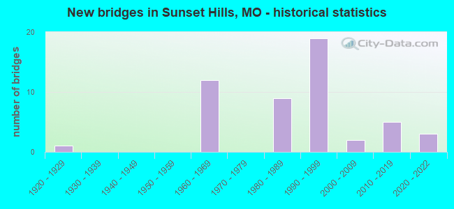
- New bridges - historical statistics
- 11920-1929
- 121960-1969
- 91980-1989
- 191990-1999
- 22000-2009
- 52010-2019
- 32020-2022
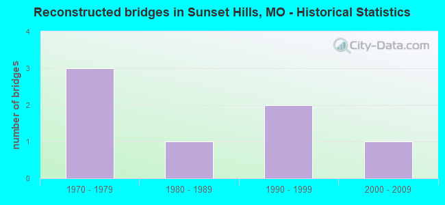
- Reconstructed bridges - Historical Statistics
- 31970-1979
- 11980-1989
- 21990-1999
- 12000-2009
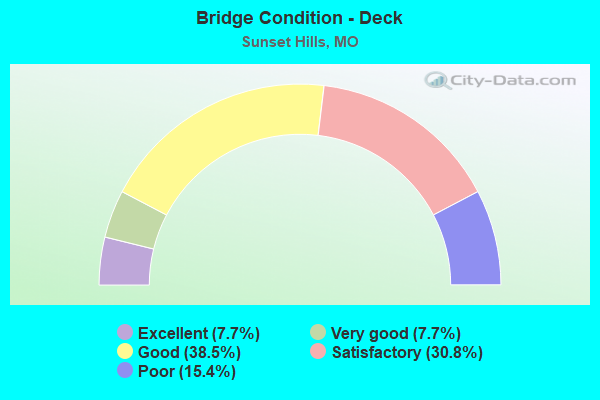
- Bridge Condition - Deck
- 7.7%Excellent
- 7.7%Very good
- 38.5%Good
- 30.8%Satisfactory
- 15.4%Poor
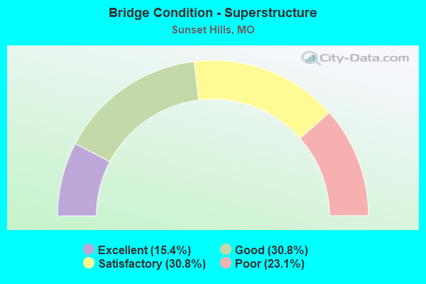
- Bridge Condition - Superstructure
- 15.4%Excellent
- 30.8%Good
- 30.8%Satisfactory
- 23.1%Poor
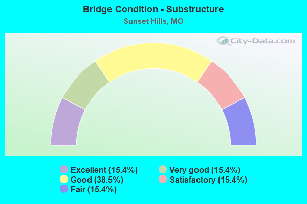
- Bridge Condition - Substructure
- 15.4%Excellent
- 15.4%Very good
- 38.5%Good
- 15.4%Satisfactory
- 15.4%Fair
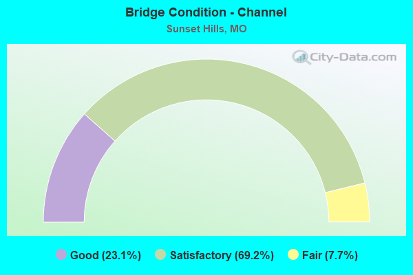
- Bridge Condition - Channel
- 23.1%Good
- 69.2%Satisfactory
- 7.7%Fair
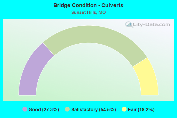
- Bridge Condition - Culverts
- 27.3%Good
- 54.5%Satisfactory
- 18.2%Fair
Find on map >> Show street view
Structure Number: 10166, Location: S 14 T 55 N R 5 E (Lat: 38.548511, Lng: -90.427175), Route carried "on" structure: Ramp State highway , Year Built: 1996, Status: Open, Structure Length: 47.61m (156.20ft), Average Daily Traffic: 13,968 (year 2021), Truck Traffic: 17%, Average Future Daily Traffic: 17,460 (year 2041), Design Load: HS 20+Mod, Features Intersected: IS 44, IS 270, RP IS270E, Facility Carried by Structure: RP IS44E TO IS270E
Minimum Vertical Clearance: 30+ m (98+ ft), Kilometerpoint: 0.455, Lanes on structure: 1, Lanes under structure: 13, Base Highway Network: Yes, Owner: State Highway Agency, Approaching Roadway Width: 8.2m (26.9ft), Material/Design: Steel continuous, Design/Construction: Stringer/Multi-beam, Number Of Spans In Main Unit: 12, Length of Maximum Span: 52.1m (170.9ft), Curb or Sidewalk Widths: Left: 0.2m (0.7ft), Right: 0.2m (0.7ft), Curb-To-Curb Width: 8.2m (26.9ft), Out-to-Out Width: 9.0m (29.5ft)
Condition: Deck: Good, Superstructure: Good, Substructure: Good, Operating Rating: 95.4 metric tons, Method Used To Determine Operating Rating: Load Factor (LF), Inventory Rating: 56.7 metric tons, Method Used To Determine Inventory Rating: Load Factor (LF), Structural Evaluation: Better than present minimum criteria, Deck Geometry: Superior to present desirable criteria, Underclear: Equal to present minimum criteria, Approach Roadway Alignment: Equal to present desirable criteria, Designated Inspection Frequency: Every 24 months, Inspection Date: May 2021, Deck Structure Type: Concrete Cast-file-Place, Wearing Surface/Protective System: Wearing Surface: Monolithic Concrete, Deck Protection: Epoxy Coated Reinforcing
Find on map >> Show street view
Structure Number: 11741, Location: S 14 T 44 N R 5 E (Lat: 38.555317, Lng: -90.416261), Route carried "on" structure: City street , Year Built: 1996, Status: Open, Structure Length: 9.78m (32.09ft), Average Daily Traffic: 8,417 (year 2021), Truck Traffic: 4%, Average Future Daily Traffic: 12,626 (year 2041), Design Load: HS 20+Mod, Features Intersected: IS 44, Facility Carried by Structure: GEYER RD S
Minimum Vertical Clearance: 30+ m (98+ ft), Kilometerpoint: 8.929, Lanes on structure: 2, Lanes under structure: 10, Owner: State Highway Agency, Approaching Roadway Width: 11.6m (38.1ft), Skew: 3 degrees, Material/Design: Steel continuous, Design/Construction: Stringer/Multi-beam, Number Of Spans In Main Unit: 4, Length of Maximum Span: 30.5m (100.1ft), Curb or Sidewalk Widths: Left: 1.5m (4.9ft), Right: 1.5m (4.9ft), Curb-To-Curb Width: 11.8m (38.7ft), Out-to-Out Width: 12.6m (41.3ft)
Condition: Deck: Satisfactory, Superstructure: Good, Substructure: Very good, Operating Rating: 85.5 metric tons, Method Used To Determine Operating Rating: Load Factor (LF), Inventory Rating: 51.3 metric tons, Method Used To Determine Inventory Rating: Load Factor (LF), Structural Evaluation: Better than present minimum criteria, Deck Geometry: Somewhat better than minimum adequacy, Underclear: Meets minimum limits, Approach Roadway Alignment: Equal to present desirable criteria, Designated Inspection Frequency: Every 24 months, Inspection Date: June 2020, Deck Structure Type: Concrete Cast-file-Place, Wearing Surface/Protective System: Wearing Surface: Monolithic Concrete, Deck Protection: Epoxy Coated Reinforcing
Find on map >> Show street view
Structure Number: 141, Location: S 131 T 46 N R 5 E (Lat: 38.758922, Lng: -90.430556), Route carried "on" structure: Interstate 270, Year Built: 1960, Year Reconstructed: 1981, Status: Open, Structure Length: 1.16m (3.81ft), Average Daily Traffic: 113,650 (year 2021), Truck Traffic: 18%, Average Future Daily Traffic: 142,063 (year 2041), Design Load: HS 20, Features Intersected: COWMIRE CR
Minimum Vertical Clearance: 30+ m (98+ ft), Kilometerpoint: 34.194, Lanes on structure: 9, Base Highway Network: Yes, Owner: State Highway Agency, Approaching Roadway Width: 39.6m (129.9ft), Material/Design: Concrete continuous, Design/Construction: Culvert, Number Of Spans In Main Unit: 3, Length of Maximum Span: 3.7m (12.1ft)
Condition: Channel: Satisfactory, Culverts: Fair, Operating Rating: 72.0 metric tons, Method Used To Determine Operating Rating: Field evaluation and documented engineering judgment, Inventory Rating: 43.2 metric tons, Method Used To Determine Inventory Rating: Field evaluation and documented engineering judgment, Structural Evaluation: Somewhat better than minimum adequacy, Waterway Adequacy: Equal to present desirable criteria, Approach Roadway Alignment: Equal to present desirable criteria, Designated Inspection Frequency: Every 24 months, Inspection Date: November 2021
Find on map >> Show street view
Structure Number: 141, Location: S 12 T 44 N R 5 E (Lat: 38.559272, Lng: -90.406925), Route carried "on" structure: Interstate 44, Year Built: 1967, Year Reconstructed: 1997, Status: Posted for load, Structure Length: 5.70m (18.70ft), Average Daily Traffic: 39,156 (year 2021), Truck Traffic: 12%, Average Future Daily Traffic: 48,945 (year 2041), Design Load: HS 20, Features Intersected: US 50, US 61
Minimum Vertical Clearance: 30+ m (98+ ft), Kilometerpoint: 446.766, Lanes on structure: 4, Lanes under structure: 6, Base Highway Network: Yes, Owner: State Highway Agency, Approaching Roadway Width: 12.2m (40.0ft), Skew: 1 degrees, Material/Design: Concrete continuous, Design/Construction: Slab, Number Of Spans In Main Unit: 4, Length of Maximum Span: 16.0m (52.5ft), Curb or Sidewalk Widths: Left: 0.4m (1.3ft), Right: 0.4m (1.3ft), Curb-To-Curb Width: 20.3m (66.6ft), Out-to-Out Width: 21.2m (69.6ft)
Condition: Deck: Satisfactory, Superstructure: Satisfactory, Substructure: Good, Operating Rating: 42.3 metric tons, Method Used To Determine Operating Rating: Load Factor (LF), Inventory Rating: 25.2 metric tons, Method Used To Determine Inventory Rating: Load Factor (LF), Structural Evaluation: Equal to present minimum criteria, Deck Geometry: Equal to present minimum criteria, Underclear: Meets minimum limits, Approach Roadway Alignment: Equal to present desirable criteria, Designated Inspection Frequency: Every 24 months, Inspection Date: June 2020, Deck Structure Type: Concrete Cast-file-Place, Wearing Surface/Protective System: Wearing Surface: Bituminous, Membrane: Built-up, Deck Protection: Cathodic Protection
Find on map >> Show street view
Structure Number: 1411, Location: S 12 T 44 N R 5 E (Lat: 38.559514, Lng: -90.406922), Route carried "on" structure: Interstate 44, Year Built: 1967, Year Reconstructed: 1997, Status: Posted for load, Structure Length: 5.70m (18.70ft), Average Daily Traffic: 44,222 (year 2021), Truck Traffic: 12%, Average Future Daily Traffic: 55,278 (year 2041), Design Load: HS 20, Features Intersected: US 50, US 61
Minimum Vertical Clearance: 30+ m (98+ ft), Kilometerpoint: 24.874, Lanes on structure: 4, Lanes under structure: 6, Base Highway Network: Yes, Owner: State Highway Agency, Approaching Roadway Width: 12.2m (40.0ft), Skew: 1 degrees, Material/Design: Concrete continuous, Design/Construction: Slab, Number Of Spans In Main Unit: 4, Length of Maximum Span: 16.0m (52.5ft), Curb or Sidewalk Widths: Left: 0.4m (1.3ft), Right: 0.4m (1.3ft), Curb-To-Curb Width: 20.3m (66.6ft), Out-to-Out Width: 21.2m (69.6ft)
Condition: Deck: Satisfactory, Superstructure: Satisfactory, Substructure: Good, Operating Rating: 42.3 metric tons, Method Used To Determine Operating Rating: Load Factor (LF), Inventory Rating: 25.2 metric tons, Method Used To Determine Inventory Rating: Load Factor (LF), Structural Evaluation: Equal to present minimum criteria, Deck Geometry: Equal to present minimum criteria, Underclear: Meets minimum limits, Approach Roadway Alignment: Equal to present desirable criteria, Designated Inspection Frequency: Every 24 months, Inspection Date: June 2020, Deck Structure Type: Concrete Cast-file-Place, Wearing Surface/Protective System: Wearing Surface: Bituminous, Membrane: Built-up, Deck Protection: Cathodic Protection
Find on map >> Show street view
Structure Number: 1412, Location: S 12 T 44 N R 6 E (Lat: 38.567811, Lng: -90.393744), Route carried "on" structure: County highway , Year Built: 1967, Year Reconstructed: 1984, Status: Posted for load, Structure Length: 7.80m (25.59ft), Average Daily Traffic: 10,289 (year 2021), Truck Traffic: 5%, Average Future Daily Traffic: 14,405 (year 2041), Design Load: HS 20, Features Intersected: IS 44, Facility Carried by Structure: BIG BEND RD E
Minimum Vertical Clearance: 30+ m (98+ ft), Kilometerpoint: 14.405, Lanes on structure: 3, Lanes under structure: 8, Owner: State Highway Agency, Approaching Roadway Width: 14.6m (47.9ft), Skew: 2 degrees, Material/Design: Concrete continuous, Design/Construction: Box Beam or Girders - Single/Spread, Number Of Spans In Main Unit: 4, Length of Maximum Span: 24.7m (81.0ft), Curb or Sidewalk Widths: Left: 0.2m (0.7ft), Right: 0.0m, Curb-To-Curb Width: 11.6m (38.1ft), Out-to-Out Width: 13.0m (42.7ft)
Condition: Deck: Poor, Superstructure: Poor, Substructure: Fair, Operating Rating: 51.3 metric tons, Method Used To Determine Operating Rating: Load Factor (LF), Inventory Rating: 30.6 metric tons, Method Used To Determine Inventory Rating: Load Factor (LF), Structural Evaluation: Meets minimum limits, Deck Geometry: High priority of replacement, Underclear: Meets minimum limits, Approach Roadway Alignment: Equal to present desirable criteria, Length Of Structure Improvement: 0.88m (2.89ft), Designated Inspection Frequency: Every 24 months, Inspection Date: June 2020, Bridge Improvement Cost: $1,318,000, Roadway Improvement Cost: $132,000, Total Project Cost: $1,976,000 ( Estimate for 2022), Deck Structure Type: Concrete Cast-file-Place, Wearing Surface/Protective System: Wearing Surface: Bituminous, Membrane: Built-up
Find on map >> Show street view
Structure Number: 1413, Location: S 12 T 44 N R 6 E (Lat: 38.567911, Lng: -90.393675), Route carried "on" structure: County highway , Year Built: 1967, Year Reconstructed: 1984, Status: Posted for load, Structure Length: 7.80m (25.59ft), Average Daily Traffic: 10,525 (year 2021), Truck Traffic: 5%, Average Future Daily Traffic: 14,735 (year 2041), Design Load: HS 20, Features Intersected: IS 44, Facility Carried by Structure: BIG BEND RD W
Minimum Vertical Clearance: 30+ m (98+ ft), Kilometerpoint: 1.571, Lanes on structure: 3, Lanes under structure: 8, Owner: State Highway Agency, Approaching Roadway Width: 14.6m (47.9ft), Skew: 2 degrees, Material/Design: Concrete continuous, Design/Construction: Box Beam or Girders - Single/Spread, Number Of Spans In Main Unit: 4, Length of Maximum Span: 24.7m (81.0ft), Curb or Sidewalk Widths: Left: 0.2m (0.7ft), Right: 0.0m, Curb-To-Curb Width: 11.6m (38.1ft), Out-to-Out Width: 13.0m (42.7ft)
Condition: Deck: Poor, Superstructure: Poor, Substructure: Fair, Operating Rating: 51.3 metric tons, Method Used To Determine Operating Rating: Load Factor (LF), Inventory Rating: 30.6 metric tons, Method Used To Determine Inventory Rating: Load Factor (LF), Structural Evaluation: Meets minimum limits, Deck Geometry: High priority of replacement, Underclear: Meets minimum limits, Approach Roadway Alignment: Equal to present desirable criteria, Length Of Structure Improvement: 0.88m (2.89ft), Designated Inspection Frequency: Every 24 months, Inspection Date: June 2020, Bridge Improvement Cost: $1,318,000, Roadway Improvement Cost: $132,000, Total Project Cost: $1,976,000 ( Estimate for 2022), Deck Structure Type: Concrete Cast-file-Place, Wearing Surface/Protective System: Wearing Surface: Bituminous, Membrane: Built-up
Find on map >> Show street view
Structure Number: 1414, Location: S 13 T 44 N R 5 E (Lat: 38.567894, Lng: -90.392581), Route carried "on" structure: County highway , Year Built: 1967, Status: Open, Structure Length: 1.29m (4.23ft), Average Daily Traffic: 20,555 (year 2021), Truck Traffic: 5%, Average Future Daily Traffic: 28,777 (year 2041), Design Load: HS 20, Features Intersected: GRAVOIS CR, Facility Carried by Structure: BIG BEND RD E
Minimum Vertical Clearance: 30+ m (98+ ft), Kilometerpoint: 14.520, Lanes on structure: 4, Owner: State Highway Agency, Approaching Roadway Width: 41.5m (136.2ft), Skew: 1 degrees, Material/Design: Concrete continuous, Design/Construction: Culvert, Number Of Spans In Main Unit: 3, Length of Maximum Span: 4.0m (13.1ft)
Condition: Channel: Satisfactory, Culverts: Fair, Operating Rating: 87.3 metric tons, Method Used To Determine Operating Rating: Field evaluation and documented engineering judgment, Inventory Rating: 52.2 metric tons, Method Used To Determine Inventory Rating: Field evaluation and documented engineering judgment, Structural Evaluation: Somewhat better than minimum adequacy, Waterway Adequacy: Equal to present desirable criteria, Approach Roadway Alignment: Equal to present desirable criteria, Designated Inspection Frequency: Every 24 months, Inspection Date: November 2021
Find on map >> Show street view
Structure Number: 23607, Location: S 23 T 44 N R 5 E (Lat: 38.527622, Lng: -90.423694), Route carried "on" structure: City street , Year Built: 1994, Status: Open, Structure Length: 1.01m (3.31ft), Average Daily Traffic: 2,529 (year 2020), Truck Traffic: 1%, Average Future Daily Traffic: 3,414 (year 2040), Design Load: HS 20, Features Intersected: GRAVOIS CREEK BR, Facility Carried by Structure: W WATSON RD
Minimum Vertical Clearance: 30+ m (98+ ft), Kilometerpoint: 0.161, Lanes on structure: 2, Owner: City or Municipal Highway Agency, Approaching Roadway Width: 7.3m (24.0ft), Skew: 4 degrees, Material/Design: Concrete continuous, Design/Construction: Culvert, Number Of Spans In Main Unit: 3, Length of Maximum Span: 4.0m (13.1ft), Curb-To-Curb Width: 8.2m (26.9ft), Out-to-Out Width: 10.1m (33.1ft)
Condition: Channel: Satisfactory, Culverts: Satisfactory, Operating Rating: 54.0 metric tons, Method Used To Determine Operating Rating: Load Factor (LF), Inventory Rating: 32.4 metric tons, Method Used To Determine Inventory Rating: Load Factor (LF), Structural Evaluation: Equal to present minimum criteria, Deck Geometry: High priority of corrective action, Waterway Adequacy: Equal to present desirable criteria, Approach Roadway Alignment: Equal to present desirable criteria, Designated Inspection Frequency: Every 24 months, Inspection Date: November 2021, Deck Structure Type: Concrete Cast-file-Place, Wearing Surface/Protective System: Wearing Surface: Bituminous, Deck Protection: Epoxy Coated Reinforcing
Find on map >> Show street view
Structure Number: 23609, Location: S 3116 T 44 N R 5 E (Lat: 38.513806, Lng: -90.425994), Route carried "on" structure: City street , Year Built: 1925, Year Reconstructed: 1991, Status: Posted for load, Structure Length: 1.10m (3.61ft), Average Daily Traffic: 9,270 (year 2020), Truck Traffic: 2%, Average Future Daily Traffic: 12,515 (year 2040), Design Load: H 15, Features Intersected: CR TO MERAMEC RVR, Facility Carried by Structure: GRAVOIS RD
Minimum Vertical Clearance: 30+ m (98+ ft), Kilometerpoint: 0.000, Lanes on structure: 2, Owner: City or Municipal Highway Agency, Approaching Roadway Width: 11.9m (39.0ft), Skew: 2 degrees, Material/Design: Concrete continuous, Design/Construction: Culvert, Number Of Spans In Main Unit: 2, Length of Maximum Span: 4.6m (15.1ft)
Condition: Channel: Satisfactory, Culverts: Satisfactory, Operating Rating: 89.1 metric tons, Method Used To Determine Operating Rating: Allowable Stress (AS), Inventory Rating: 67.5 metric tons, Method Used To Determine Inventory Rating: Allowable Stress (AS), Structural Evaluation: Equal to present minimum criteria, Waterway Adequacy: Somewhat better than minimum adequacy, Approach Roadway Alignment: Equal to present desirable criteria, Designated Inspection Frequency: Every 24 months, Inspection Date: November 2021
Find on map >> Show street view
Structure Number: 2595, Location: S 13 T 44 N R 5 E (Lat: 38.555497, Lng: -90.406975), Route carried "on" structure: State highway 366, Year Built: 1983, Status: Open, Structure Length: 4.72m (15.49ft), Average Daily Traffic: 24,847 (year 2021), Truck Traffic: 13%, Average Future Daily Traffic: 34,786 (year 2041), Design Load: HS 20+Mod, Features Intersected: US 50
Minimum Vertical Clearance: 30+ m (98+ ft), Kilometerpoint: 2.176, Lanes on structure: 6, Lanes under structure: 4, Base Highway Network: Yes, Owner: State Highway Agency, Approaching Roadway Width: 28.0m (91.9ft), Skew: 20 degrees, Material/Design: Prestressed concrete continuous, Design/Construction: Stringer/Multi-beam, Number Of Spans In Main Unit: 4, Length of Maximum Span: 14.0m (45.9ft), Curb or Sidewalk Widths: Left: 0.2m (0.7ft), Right: 0.2m (0.7ft), Curb-To-Curb Width: 28.0m (91.9ft), Out-to-Out Width: 29.0m (95.1ft)
Condition: Deck: Good, Superstructure: Satisfactory, Substructure: Good, Operating Rating: 90.9 metric tons, Method Used To Determine Operating Rating: Load Factor (LF), Inventory Rating: 40.5 metric tons, Method Used To Determine Inventory Rating: Load Factor (LF), Structural Evaluation: Equal to present minimum criteria, Deck Geometry: Superior to present desirable criteria, Underclear: Equal to present minimum criteria, Approach Roadway Alignment: Equal to present desirable criteria, Designated Inspection Frequency: Every 24 months, Inspection Date: July 2020, Deck Structure Type: Concrete Cast-file-Place, Wearing Surface/Protective System: Wearing Surface: Monolithic Concrete, Deck Protection: Epoxy Coated Reinforcing
Find on map >> Show street view
Structure Number: 3031, Location: S 22 T 44 N R 5 E (Lat: 38.542900, Lng: -90.454297), Route carried "on" structure: Ramp State highway , Year Built: 1981, Year Reconstructed: 2014, Status: Open, Structure Length: 11.16m (36.61ft), Average Daily Traffic: 1,117 (year 2021), Truck Traffic: 5%, Average Future Daily Traffic: 1,676 (year 2041), Design Load: HS 20, Features Intersected: IS 44, OR 44, Facility Carried by Structure: RP SOR44E TO MRAZ
Minimum Vertical Clearance: 30+ m (98+ ft), Kilometerpoint: 0.327, Lanes on structure: 4, Lanes under structure: 12, Owner: State Highway Agency, Approaching Roadway Width: 22.6m (74.1ft), Skew: 20 degrees, Material/Design: Steel continuous, Design/Construction: Stringer/Multi-beam, Number Of Spans In Main Unit: 6, Length of Maximum Span: 24.2m (79.4ft), Curb-To-Curb Width: 21.6m (70.9ft), Out-to-Out Width: 23.6m (77.4ft)
Condition: Deck: Satisfactory, Superstructure: Poor, Substructure: Satisfactory, Operating Rating: 56.7 metric tons, Method Used To Determine Operating Rating: Load Factor (LF), Inventory Rating: 34.2 metric tons, Method Used To Determine Inventory Rating: Load Factor (LF), Structural Evaluation: Meets minimum limits, Deck Geometry: Superior to present desirable criteria, Underclear: Meets minimum limits, Approach Roadway Alignment: Better than present minimum criteria, Designated Inspection Frequency: Every 24 months, Other Special Inspection Frequency: Every 24 months, Inspection Date: June 2020, Other Special Inspection Date: March 2021, Deck Structure Type: Concrete Cast-file-Place, Wearing Surface/Protective System: Wearing Surface: Monolithic Concrete, Deck Protection: Epoxy Coated Reinforcing
Find on map >> Show street view
Structure Number: 32513, Location: S 26 T 44 N R 5 E (Lat: 38.525081, Lng: -90.427500), Route carried "on" structure: City street 419, Year Built: 2009, Status: Open, Structure Length: 1.49m (4.89ft), Average Daily Traffic: 2,529 (year 2020), Truck Traffic: 2%, Average Future Daily Traffic: 3,414 (year 2040), Design Load: HS 20, Features Intersected: TRIB B, Facility Carried by Structure: W WATSON RD
Minimum Vertical Clearance: 30+ m (98+ ft), Kilometerpoint: 0.322, Lanes on structure: 2, Owner: City or Municipal Highway Agency, Approaching Roadway Width: 6.4m (21.0ft), Skew: 1 degrees, Material/Design: Concrete continuous, Design/Construction: Culvert, Number Of Spans In Main Unit: 3, Length of Maximum Span: 4.6m (15.1ft), Curb-To-Curb Width: 10.4m (34.1ft), Out-to-Out Width: 11.3m (37.1ft)
Condition: Channel: Satisfactory, Culverts: Satisfactory, Operating Rating: 61.2 metric tons, Method Used To Determine Operating Rating: Load Factor (LF), Inventory Rating: 36.9 metric tons, Method Used To Determine Inventory Rating: Load Factor (LF), Structural Evaluation: Equal to present minimum criteria, Deck Geometry: Somewhat better than minimum adequacy, Waterway Adequacy: Better than present minimum criteria, Approach Roadway Alignment: Equal to present desirable criteria, Designated Inspection Frequency: Every 24 months, Inspection Date: November 2021, Deck Structure Type: Concrete Cast-file-Place, Wearing Surface/Protective System: Wearing Surface: Bituminous, Deck Protection: Epoxy Coated Reinforcing
Find on map >> Show street view
Structure Number: 32779, Location: S 23 T 44 N R 5 E (Lat: 38.538056, Lng: -90.421111), Route carried "on" structure: City street 419, Year Built: 2009, Status: Open, Structure Length: 0.94m (3.08ft), Average Daily Traffic: 100 (year 2020), Truck Traffic: 1%, Average Future Daily Traffic: 135 (year 2040), Design Load: HS 20, Features Intersected: TRIB B, Facility Carried by Structure: BAALBEK DR
Minimum Vertical Clearance: 30+ m (98+ ft), Kilometerpoint: 0.016, Lanes on structure: 2, Owner: City or Municipal Highway Agency, Approaching Roadway Width: 7.9m (25.9ft), Material/Design: Concrete continuous, Design/Construction: Culvert, Number Of Spans In Main Unit: 2, Length of Maximum Span: 4.6m (15.1ft), Curb-To-Curb Width: 8.2m (26.9ft), Out-to-Out Width: 9.4m (30.8ft)
Condition: Channel: Good, Culverts: Good, Operating Rating: 59.4 metric tons, Method Used To Determine Operating Rating: Load Factor (LF), Inventory Rating: 35.1 metric tons, Method Used To Determine Inventory Rating: Load Factor (LF), Structural Evaluation: Better than present minimum criteria, Deck Geometry: Equal to present minimum criteria, Waterway Adequacy: Equal to present desirable criteria, Approach Roadway Alignment: Equal to present desirable criteria, Designated Inspection Frequency: Every 24 months, Inspection Date: November 2021, Deck Structure Type: Concrete Cast-file-Place, Wearing Surface/Protective System: Wearing Surface: Bituminous
Find on map >> Show street view
Structure Number: 33412, Location: S 23 T 44 N R 5 E (Lat: 38.534100, Lng: -90.421572), Route carried "on" structure: City street , Year Built: 2011, Status: Open, Structure Length: 1.32m (4.33ft), Average Daily Traffic: 3,240 (year 2020), Truck Traffic: 2%, Average Future Daily Traffic: 4,374 (year 2040), Design Load: HS 20, Features Intersected: TRIB B, Facility Carried by Structure: W WATSON RD
Minimum Vertical Clearance: 30+ m (98+ ft), Kilometerpoint: 2.271, Lanes on structure: 2, Owner: City or Municipal Highway Agency, Approaching Roadway Width: 7.3m (24.0ft), Skew: 3 degrees, Material/Design: Concrete continuous, Design/Construction: Culvert, Number Of Spans In Main Unit: 3, Length of Maximum Span: 3.7m (12.1ft), Curb-To-Curb Width: 10.4m (34.1ft), Out-to-Out Width: 12.6m (41.3ft)
Condition: Channel: Fair, Culverts: Satisfactory, Operating Rating: 68.4 metric tons, Method Used To Determine Operating Rating: Load Factor (LF), Inventory Rating: 41.4 metric tons, Method Used To Determine Inventory Rating: Load Factor (LF), Structural Evaluation: Equal to present minimum criteria, Deck Geometry: Somewhat better than minimum adequacy, Waterway Adequacy: Equal to present minimum criteria, Approach Roadway Alignment: Equal to present desirable criteria, Designated Inspection Frequency: Every 24 months, Inspection Date: November 2021, Deck Structure Type: Concrete Cast-file-Place, Wearing Surface/Protective System: Wearing Surface: Bituminous
Find on map >> Show street view
Structure Number: 33414, Location: S 23 T 44 N R 5 E (Lat: 38.531050, Lng: -90.421558), Route carried "on" structure: City street , Year Built: 2012, Status: Open, Structure Length: 1.02m (3.35ft), Average Daily Traffic: 3,240 (year 2020), Truck Traffic: 2%, Average Future Daily Traffic: 4,374 (year 2040), Design Load: HS 20, Features Intersected: TRIB B, Facility Carried by Structure: W WATSON RD
Minimum Vertical Clearance: 30+ m (98+ ft), Kilometerpoint: 2.604, Lanes on structure: 2, Owner: City or Municipal Highway Agency, Approaching Roadway Width: 7.3m (24.0ft), Skew: 2 degrees, Material/Design: Concrete continuous, Design/Construction: Culvert, Number Of Spans In Main Unit: 3, Length of Maximum Span: 3.4m (11.2ft), Curb-To-Curb Width: 10.4m (34.1ft), Out-to-Out Width: 12.6m (41.3ft)
Condition: Channel: Satisfactory, Culverts: Satisfactory, Operating Rating: 58.5 metric tons, Method Used To Determine Operating Rating: Load Factor (LF), Inventory Rating: 35.1 metric tons, Method Used To Determine Inventory Rating: Load Factor (LF), Structural Evaluation: Equal to present minimum criteria, Deck Geometry: Somewhat better than minimum adequacy, Waterway Adequacy: Equal to present minimum criteria, Approach Roadway Alignment: Equal to present desirable criteria, Designated Inspection Frequency: Every 24 months, Inspection Date: November 2021, Deck Structure Type: Concrete Cast-file-Place, Wearing Surface/Protective System: Wearing Surface: Bituminous
Find on map >> Show street view
Structure Number: 33432, Location: S 23 T 44 N R 5 E (Lat: 38.530167, Lng: -90.421417), Route carried "on" structure: City street , Year Built: 2012, Status: Posted for load-capacity, Structure Length: 1.32m (4.33ft), Average Daily Traffic: 3,240 (year 2020), Truck Traffic: 2%, Average Future Daily Traffic: 4,374 (year 2040), Design Load: HS 20, Features Intersected: TRIB B, Facility Carried by Structure: WEBER HILL RD
Minimum Vertical Clearance: 30+ m (98+ ft), Kilometerpoint: 0.000, Lanes on structure: 2, Owner: City or Municipal Highway Agency, Approaching Roadway Width: 6.7m (22.0ft), Skew: 2 degrees, Material/Design: Concrete continuous, Design/Construction: Culvert, Number Of Spans In Main Unit: 3, Length of Maximum Span: 4.0m (13.1ft), Curb-To-Curb Width: 8.5m (27.9ft), Out-to-Out Width: 9.8m (32.2ft)
Condition: Channel: Good, Culverts: Good, Operating Rating: 54.9 metric tons, Method Used To Determine Operating Rating: Load Factor (LF), Inventory Rating: 33.3 metric tons, Method Used To Determine Inventory Rating: Load Factor (LF), Structural Evaluation: Better than present minimum criteria, Deck Geometry: Meets minimum limits, Waterway Adequacy: Better than present minimum criteria, Approach Roadway Alignment: Somewhat better than minimum adequacy, Designated Inspection Frequency: Every 24 months, Inspection Date: November 2021, Deck Structure Type: Concrete Cast-file-Place, Wearing Surface/Protective System: Wearing Surface: Bituminous
Find on map >> Show street view
Structure Number: 33433, Location: S 23 T 44 N R 5 E (Lat: 38.536194, Lng: -90.420722), Route carried "on" structure: City street , Year Built: 2012, Status: Posted for load, Structure Length: 0.96m (3.15ft), Average Daily Traffic: 600 (year 2020), Truck Traffic: 2%, Average Future Daily Traffic: 810 (year 2040), Design Load: HS 20, Features Intersected: TRIB B, Facility Carried by Structure: W WATSON RD
Minimum Vertical Clearance: 30+ m (98+ ft), Kilometerpoint: 0.000, Lanes on structure: 2, Owner: City or Municipal Highway Agency, Approaching Roadway Width: 6.7m (22.0ft), Material/Design: Concrete continuous, Design/Construction: Culvert, Number Of Spans In Main Unit: 3, Length of Maximum Span: 3.0m (9.8ft), Curb-To-Curb Width: 8.5m (27.9ft), Out-to-Out Width: 11.1m (36.4ft)
Condition: Channel: Satisfactory, Culverts: Good, Operating Rating: 60.3 metric tons, Method Used To Determine Operating Rating: Load Factor (LF), Inventory Rating: 36.0 metric tons, Method Used To Determine Inventory Rating: Load Factor (LF), Structural Evaluation: Better than present minimum criteria, Deck Geometry: Somewhat better than minimum adequacy, Waterway Adequacy: Better than present minimum criteria, Approach Roadway Alignment: Equal to present desirable criteria, Designated Inspection Frequency: Every 24 months, Inspection Date: November 2021, Deck Structure Type: Concrete Cast-file-Place, Wearing Surface/Protective System: Wearing Surface: Bituminous
Find on map >> Show street view
Structure Number: 3568, Location: S 2 T 48 N R 32 W (Lat: 38.999144, Lng: -94.416125), Route carried "on" structure: State highway V, Year Built: 1985, Status: Open, Structure Length: 4.15m (13.62ft), Average Daily Traffic: 8,428 (year 2021), Truck Traffic: 2%, Average Future Daily Traffic: 11,378 (year 2041), Design Load: HS 20+Mod, Features Intersected: FK LIT BLUE RVR
Minimum Vertical Clearance: 30+ m (98+ ft), Kilometerpoint: 4.173, Lanes on structure: 3, Base Highway Network: Yes, Owner: State Highway Agency, Approaching Roadway Width: 15.8m (51.8ft), Skew: 1 degrees, Material/Design: Prestressed concrete continuous, Design/Construction: Tee Beam, Number Of Spans In Main Unit: 3, Length of Maximum Span: 14.9m (48.9ft), Curb or Sidewalk Widths: Left: 0.2m (0.7ft), Right: 0.2m (0.7ft), Curb-To-Curb Width: 16.7m (54.8ft), Out-to-Out Width: 17.5m (57.4ft)
Condition: Deck: Good, Superstructure: Good, Substructure: Very good, Channel: Good, Operating Rating: 63.0 metric tons, Method Used To Determine Operating Rating: Load Factor (LF), Inventory Rating: 37.8 metric tons, Method Used To Determine Inventory Rating: Load Factor (LF), Structural Evaluation: Better than present minimum criteria, Deck Geometry: Superior to present desirable criteria, Waterway Adequacy: Equal to present desirable criteria, Approach Roadway Alignment: Equal to present desirable criteria, Designated Inspection Frequency: Every 24 months, Inspection Date: October 2021, Deck Structure Type: Concrete Cast-file-Place, Wearing Surface/Protective System: Wearing Surface: Monolithic Concrete, Deck Protection: Epoxy Coated Reinforcing
Find on map >> Show street view
Structure Number: 3568, Location: S 3116 T 44 N R 5 E (Lat: 38.517500, Lng: -90.416667), Route carried "on" structure: City street , Year Built: 1990, Status: Open, Structure Length: 0.78m (2.56ft), Average Daily Traffic: 600 (year 2020), Truck Traffic: 2%, Average Future Daily Traffic: 810 (year 2040), Design Load: HS 20, Features Intersected: WATERWAY, Facility Carried by Structure: RAHNING RD
Minimum Vertical Clearance: 30+ m (98+ ft), Kilometerpoint: 0.000, Lanes on structure: 2, Owner: City or Municipal Highway Agency, Approaching Roadway Width: 9.1m (29.9ft), Material/Design: Concrete, Design/Construction: Culvert, Number Of Spans In Main Unit: 2, Length of Maximum Span: 3.8m (12.5ft), Curb-To-Curb Width: 7.3m (24.0ft), Out-to-Out Width: 9.1m (29.9ft)
Condition: Channel: Satisfactory, Culverts: Satisfactory, Operating Rating: 54.0 metric tons, Method Used To Determine Operating Rating: Field evaluation and documented engineering judgment, Inventory Rating: 32.4 metric tons, Method Used To Determine Inventory Rating: Field evaluation and documented engineering judgment, Structural Evaluation: Equal to present minimum criteria, Deck Geometry: Meets minimum limits, Waterway Adequacy: Superior to present desirable criteria, Approach Roadway Alignment: Equal to present desirable criteria, Designated Inspection Frequency: Every 24 months, Inspection Date: November 2021
Find on map >> Show street view
Structure Number: 35857, Location: S 14 T 44 N R 5 E (Lat: 38.547853, Lng: -90.429306), Route carried "on" structure: Ramp State highway , Year Built: 2018, Status: Open, Structure Length: 3.28m (10.76ft), Average Daily Traffic: 14,913 (year 2021), Truck Traffic: 15%, Average Future Daily Traffic: 18,641 (year 2041), Features Intersected: RAMP 3A-1, Facility Carried by Structure: RP IS270W TO IS44W
Minimum Vertical Clearance: 30+ m (98+ ft), Kilometerpoint: 0.409, Lanes on structure: 2, Lanes under structure: 1, Base Highway Network: Yes, Owner: State Highway Agency, Approaching Roadway Width: 8.5m (27.9ft), Skew: 4 degrees, Material/Design: Prestressed concrete, Design/Construction: Tee Beam, Number Of Spans In Main Unit: 1, Length of Maximum Span: 31.3m (102.7ft), Curb-To-Curb Width: 8.6m (28.2ft), Out-to-Out Width: 9.3m (30.5ft)
Condition: Deck: Very good, Superstructure: Excellent, Substructure: Excellent, Operating Rating: 86.4 metric tons, Method Used To Determine Operating Rating: Load Factor (LF), Inventory Rating: 29.7 metric tons, Method Used To Determine Inventory Rating: Load Factor (LF), Structural Evaluation: Better than present minimum criteria, Deck Geometry: Meets minimum limits, Approach Roadway Alignment: Equal to present desirable criteria, Designated Inspection Frequency: Every 24 months, Inspection Date: March 2021, Deck Structure Type: Concrete Precast Panels, Wearing Surface/Protective System: Wearing Surface: Monolithic Concrete, Deck Protection: Epoxy Coated Reinforcing
Find on map >> Show street view
Structure Number: 3665, Location: S 647 T 57 N R 33 W (Lat: 39.776681, Lng: -94.651961), Route carried "on" structure: State highway 6, Year Built: 1987, Status: Open, Structure Length: 2.96m (9.71ft), Average Daily Traffic: 1,477 (year 2021), Truck Traffic: 15%, Average Future Daily Traffic: 1,920 (year 2041), Design Load: HS 20, Features Intersected: MUDDY CR
Minimum Vertical Clearance: 30+ m (98+ ft), Kilometerpoint: 13.327, Lanes on structure: 2, Owner: State Highway Agency, Approaching Roadway Width: 10.4m (34.1ft), Skew: 2 degrees, Material/Design: Prestressed concrete continuous, Design/Construction: Tee Beam, Number Of Spans In Main Unit: 3, Length of Maximum Span: 11.5m (37.7ft), Curb or Sidewalk Widths: Left: 0.2m (0.7ft), Right: 0.2m (0.7ft), Curb-To-Curb Width: 10.0m (32.8ft), Out-to-Out Width: 10.8m (35.4ft)
Condition: Deck: Good, Superstructure: Satisfactory, Substructure: Satisfactory, Channel: Satisfactory, Operating Rating: 58.5 metric tons, Method Used To Determine Operating Rating: Load Factor (LF), Inventory Rating: 26.1 metric tons, Method Used To Determine Inventory Rating: Load Factor (LF), Structural Evaluation: Equal to present minimum criteria, Deck Geometry: Somewhat better than minimum adequacy, Waterway Adequacy: Equal to present desirable criteria, Approach Roadway Alignment: Equal to present desirable criteria, Designated Inspection Frequency: Every 24 months, Inspection Date: August 2020, Deck Structure Type: Concrete Cast-file-Place, Wearing Surface/Protective System: Wearing Surface: Monolithic Concrete, Deck Protection: Epoxy Coated Reinforcing
Find on map >> Show street view
Structure Number: 3665, Location: S 7 T 44 N R 6 E (Lat: 38.567811, Lng: -90.393744), Route carried "on" structure: County highway , Year Built: 2022, Status: Not yet open, Structure Length: 5.39m (17.68ft), Average Daily Traffic: 20,814 (year 2021), Truck Traffic: 5%, Average Future Daily Traffic: 29,140 (year 2041), Features Intersected: IS 44, Facility Carried by Structure: BIG BEND RD E
Minimum Vertical Clearance: 30+ m (98+ ft), Kilometerpoint: 14.412, Lanes on structure: 6, Lanes under structure: 8, Owner: State Highway Agency, Approaching Roadway Width: 29.7m (97.4ft), Skew: 2 degrees, Material/Design: Prestressed concrete, Design/Construction: Tee Beam, Number Of Spans In Main Unit: 2, Length of Maximum Span: 26.9m (88.3ft), Curb-To-Curb Width: 24.4m (80.1ft), Out-to-Out Width: 29.7m (97.4ft)
Condition: Deck: Excellent, Superstructure: Excellent, Substructure: Excellent, Operating Rating: 67.5 metric tons, Method Used To Determine Operating Rating: Load and Resistance Factor (LRFR), Inventory Rating: 40.5 metric tons, Method Used To Determine Inventory Rating: Load and Resistance Factor (LRFR), Structural Evaluation: Superior to present desirable criteria, Deck Geometry: Somewhat better than minimum adequacy, Underclear: High priority of corrective action, Approach Roadway Alignment: Equal to present desirable criteria, Designated Inspection Frequency: Every 24 months, Inspection Date: September 2021, Deck Structure Type: Concrete Cast-file-Place, Wearing Surface/Protective System: Wearing Surface: Monolithic Concrete, Deck Protection: Epoxy Coated Reinforcing
Find on map >> Show street view
Structure Number: 4266, Location: S 14 T 44 N R 5 E (Lat: 38.548167, Lng: -90.426797), Route carried "on" structure: Ramp State highway , Year Built: 1996, Status: Open, Structure Length: 45.84m (150.39ft), Average Daily Traffic: 15,527 (year 2021), Truck Traffic: 5%, Average Future Daily Traffic: 19,409 (year 2041), Design Load: HS 20+Mod, Features Intersected: IS 270, IS 44, RP IS270E, Facility Carried by Structure: RP IS44W TO IS270W
Minimum Vertical Clearance: 30+ m (98+ ft), Kilometerpoint: 1.009, Lanes on structure: 1, Lanes under structure: 17, Base Highway Network: Yes, Owner: State Highway Agency, Approaching Roadway Width: 8.2m (26.9ft), Material/Design: Steel continuous, Design/Construction: Stringer/Multi-beam, Number Of Spans In Main Unit: 13, Length of Maximum Span: 48.8m (160.1ft), Curb or Sidewalk Widths: Left: 0.2m (0.7ft), Right: 0.2m (0.7ft), Curb-To-Curb Width: 8.2m (26.9ft), Out-to-Out Width: 9.0m (29.5ft)
Condition: Deck: Good, Superstructure: Good, Substructure: Good, Operating Rating: 94.5 metric tons, Method Used To Determine Operating Rating: Load Factor (LF), Inventory Rating: 56.7 metric tons, Method Used To Determine Inventory Rating: Load Factor (LF), Structural Evaluation: Better than present minimum criteria, Deck Geometry: Superior to present desirable criteria, Underclear: Equal to present minimum criteria, Approach Roadway Alignment: Equal to present desirable criteria, Designated Inspection Frequency: Every 24 months, Inspection Date: May 2021, Deck Structure Type: Concrete Cast-file-Place, Wearing Surface/Protective System: Wearing Surface: Monolithic Concrete, Deck Protection: Epoxy Coated Reinforcing
Find on map >> Show street view
Structure Number: 10166, Location: S 14 T 55 N R 5 E (Lat: 38.548511, Lng: -90.427175), Route carried "under" structure: Interstate 44, Year Built: 1996, Structure Length: 0. m, Average Daily Traffic: 52,873 (year 2021), Truck Traffic: 12%, Features Intersected: IS 44
Minimum Vertical Clearance: 5.31m (17.42ft), Kilometerpoint: 444.618, Lanes on structure: 1, Lanes under structure: 1, Material/Design: Steel continuous, Design/Construction: Stringer/Multi-beam, Length of Maximum Span: 52.1m (170.9ft)
Find on map >> Show street view
Structure Number: 10166, Location: S 14 T 55 N R 5 E (Lat: 38.548511, Lng: -90.427175), Route carried "under" structure: Interstate 44, Year Built: 1996, Structure Length: 0. m, Average Daily Traffic: 54,707 (year 2021), Truck Traffic: 12%, Features Intersected: IS 44
Minimum Vertical Clearance: 5.31m (17.42ft), Kilometerpoint: 27.064, Lanes on structure: 1, Lanes under structure: 2, Material/Design: Steel continuous, Design/Construction: Stringer/Multi-beam, Length of Maximum Span: 52.1m (170.9ft)
Find on map >> Show street view
Structure Number: 10166, Location: S 14 T 55 N R 5 E (Lat: 38.548511, Lng: -90.427175), Route carried "under" structure: Interstate 270, Year Built: 1996, Structure Length: 0. m, Average Daily Traffic: 78,747 (year 2021), Truck Traffic: 18%, Features Intersected: IS 270
Minimum Vertical Clearance: 5.08m (16.67ft), Kilometerpoint: 47.720, Lanes on structure: 1, Lanes under structure: 3, Material/Design: Steel continuous, Design/Construction: Stringer/Multi-beam, Length of Maximum Span: 52.1m (170.9ft)
Find on map >> Show street view
Structure Number: 10166, Location: S 14 T 55 N R 5 E (Lat: 38.548511, Lng: -90.427175), Route carried "under" structure: Interstate 270, Year Built: 1996, Structure Length: 0. m, Average Daily Traffic: 80,882 (year 2021), Truck Traffic: 18%, Features Intersected: IS 270
Minimum Vertical Clearance: 5.03m (16.50ft), Kilometerpoint: 9.906, Lanes on structure: 1, Lanes under structure: 3, Material/Design: Steel continuous, Design/Construction: Stringer/Multi-beam, Length of Maximum Span: 52.1m (170.9ft)
Find on map >> Show street view
Structure Number: 10166, Location: S 14 T 55 N R 5 E (Lat: 38.548511, Lng: -90.427175), Route carried "under" structure: Ramp State highway , Year Built: 1996, Structure Length: 0. m, Average Daily Traffic: 10,413 (year 2021), Truck Traffic: 10%, Features Intersected: RP IS270E TO IS44W, Facility Carried by Structure: RP IS44E TO IS270E
Minimum Vertical Clearance: 5.31m (17.42ft), Kilometerpoint: 0.106, Lanes on structure: 1, Lanes under structure: 1, Material/Design: Steel continuous, Design/Construction: Stringer/Multi-beam, Length of Maximum Span: 52.1m (170.9ft)
Find on map >> Show street view
Structure Number: 10166, Location: S 14 T 55 N R 5 E (Lat: 38.548511, Lng: -90.427175), Route carried "under" structure: Ramp State highway , Year Built: 1996, Structure Length: 0. m, Average Daily Traffic: 10,413 (year 2021), Truck Traffic: 10%, Features Intersected: RP IS270E TO IS44W, Facility Carried by Structure: RP IS44E TO IS270E
Minimum Vertical Clearance: 5.49m (18.01ft), Kilometerpoint: 0.402, Lanes on structure: 1, Lanes under structure: 1, Material/Design: Steel continuous, Design/Construction: Stringer/Multi-beam, Length of Maximum Span: 52.1m (170.9ft)
Find on map >> Show street view
Structure Number: 10166, Location: S 14 T 55 N R 5 E (Lat: 38.548511, Lng: -90.427175), Route carried "under" structure: State highway 366, Year Built: 1996, Structure Length: 0. m, Average Daily Traffic: 14,341 (year 2021), Truck Traffic: 13%, Features Intersected: MO 366, Facility Carried by Structure: RP IS44E TO IS270E
Minimum Vertical Clearance: 6.58m (21.59ft), Kilometerpoint: 0.177, Lanes on structure: 1, Lanes under structure: 1, Material/Design: Steel continuous, Design/Construction: Stringer/Multi-beam, Length of Maximum Span: 52.1m (170.9ft)
Find on map >> Show street view
Structure Number: 11741, Location: S 14 T 44 N R 5 E (Lat: 38.555317, Lng: -90.416261), Route carried "under" structure: Interstate 44, Year Built: 1996, Structure Length: 0. m, Average Daily Traffic: 40,805 (year 2021), Truck Traffic: 12%, Features Intersected: IS 44, Facility Carried by Structure: GEYER RD S
Minimum Vertical Clearance: 5.44m (17.85ft), Kilometerpoint: 25.832, Lanes on structure: 2, Lanes under structure: 5, Material/Design: Steel continuous, Design/Construction: Stringer/Multi-beam, Length of Maximum Span: 30.5m (100.1ft)
Find on map >> Show street view
Structure Number: 11741, Location: S 14 T 44 N R 5 E (Lat: 38.555317, Lng: -90.416261), Route carried "under" structure: Interstate 44, Year Built: 1996, Structure Length: 0. m, Average Daily Traffic: 39,156 (year 2021), Truck Traffic: 12%, Features Intersected: IS 44, Facility Carried by Structure: GEYER RD S
Minimum Vertical Clearance: 5.82m (19.09ft), Kilometerpoint: 445.860, Lanes on structure: 2, Lanes under structure: 5, Material/Design: Steel continuous, Design/Construction: Stringer/Multi-beam, Length of Maximum Span: 30.5m (100.1ft)
Find on map >> Show street view
Structure Number: 141, Location: S 12 T 44 N R 5 E (Lat: 38.559272, Lng: -90.406925), Route carried "under" structure: US 50, Year Built: 1967, Structure Length: 0. m, Average Daily Traffic: 17,772 (year 2021), Truck Traffic: 5%, Features Intersected: US 50, Facility Carried by Structure: IS 44 E
Minimum Vertical Clearance: 4.65m (15.26ft), Kilometerpoint: 15.091, Lanes on structure: 4, Lanes under structure: 3, Material/Design: Concrete continuous, Design/Construction: Slab, Length of Maximum Span: 16.0m (52.5ft)
Find on map >> Show street view
Structure Number: 1411, Location: S 12 T 44 N R 5 E (Lat: 38.559514, Lng: -90.406922), Route carried "under" structure: US 50, Year Built: 1967, Structure Length: 0. m, Average Daily Traffic: 17,772 (year 2021), Truck Traffic: 5%, Features Intersected: US 50, Facility Carried by Structure: IS 44 W
Minimum Vertical Clearance: 4.78m (15.68ft), Kilometerpoint: 15.117, Lanes on structure: 4, Lanes under structure: 3, Material/Design: Concrete continuous, Design/Construction: Slab, Length of Maximum Span: 16.0m (52.5ft)
Find on map >> Show street view
Structure Number: 1412, Location: S 12 T 44 N R 6 E (Lat: 38.567811, Lng: -90.393744), Route carried "under" structure: Interstate 44, Year Built: 1967, Structure Length: 0. m, Average Daily Traffic: 49,008 (year 2021), Truck Traffic: 12%, Features Intersected: IS 44, Facility Carried by Structure: BIG BEND RD E
Minimum Vertical Clearance: 4.78m (15.68ft), Kilometerpoint: 23.297, Lanes on structure: 3, Lanes under structure: 4, Material/Design: Concrete continuous, Design/Construction: Box Beam or Girders - Single/Spread, Length of Maximum Span: 24.7m (81.0ft)
Find on map >> Show street view
Structure Number: 1412, Location: S 12 T 44 N R 6 E (Lat: 38.567811, Lng: -90.393744), Route carried "under" structure: Interstate 44, Year Built: 1967, Structure Length: 0. m, Average Daily Traffic: 43,476 (year 2021), Truck Traffic: 12%, Features Intersected: IS 44, Facility Carried by Structure: BIG BEND RD E
Minimum Vertical Clearance: 4.62m (15.16ft), Kilometerpoint: 448.427, Lanes on structure: 3, Lanes under structure: 4, Material/Design: Concrete continuous, Design/Construction: Box Beam or Girders - Single/Spread, Length of Maximum Span: 24.7m (81.0ft)
Find on map >> Show street view
Structure Number: 1413, Location: S 12 T 44 N R 6 E (Lat: 38.567911, Lng: -90.393675), Route carried "under" structure: Interstate 44, Year Built: 1967, Structure Length: 0. m, Average Daily Traffic: 43,476 (year 2021), Truck Traffic: 12%, Features Intersected: IS 44, Facility Carried by Structure: BIG BEND RD W
Minimum Vertical Clearance: 4.62m (15.16ft), Kilometerpoint: 448.427, Lanes on structure: 3, Lanes under structure: 4, Material/Design: Concrete continuous, Design/Construction: Box Beam or Girders - Single/Spread, Length of Maximum Span: 24.7m (81.0ft)
Find on map >> Show street view
Structure Number: 1413, Location: S 12 T 44 N R 6 E (Lat: 38.567911, Lng: -90.393675), Route carried "under" structure: Interstate 44, Year Built: 1967, Structure Length: 0. m, Average Daily Traffic: 49,008 (year 2021), Truck Traffic: 12%, Features Intersected: IS 44, Facility Carried by Structure: BIG BEND RD W
Minimum Vertical Clearance: 4.78m (15.68ft), Kilometerpoint: 23.297, Lanes on structure: 3, Lanes under structure: 4, Material/Design: Concrete continuous, Design/Construction: Box Beam or Girders - Single/Spread, Length of Maximum Span: 24.7m (81.0ft)
Find on map >> Show street view
Structure Number: 2595, Location: S 13 T 44 N R 5 E (Lat: 38.555497, Lng: -90.406975), Route carried "under" structure: US 50, Year Built: 1983, Structure Length: 0. m, Average Daily Traffic: 26,651 (year 2021), Truck Traffic: 5%, Features Intersected: US 50, Facility Carried by Structure: MO 366 E
Minimum Vertical Clearance: 5.28m (17.32ft), Kilometerpoint: 406.761, Lanes on structure: 6, Lanes under structure: 4, Material/Design: Prestressed concrete continuous, Design/Construction: Stringer/Multi-beam, Length of Maximum Span: 14.0m (45.9ft)
Find on map >> Show street view
Structure Number: 3031, Location: S 22 T 44 N R 5 E (Lat: 38.542900, Lng: -90.454297), Route carried "under" structure: Interstate 44, Year Built: 1981, Structure Length: 0. m, Average Daily Traffic: 50,875 (year 2021), Truck Traffic: 12%, Features Intersected: IS 44
Minimum Vertical Clearance: 5.13m (16.83ft), Kilometerpoint: 29.659, Lanes on structure: 4, Lanes under structure: 3, Material/Design: Steel continuous, Design/Construction: Stringer/Multi-beam, Length of Maximum Span: 24.2m (79.4ft)
Find on map >> Show street view
Structure Number: 3031, Location: S 22 T 44 N R 5 E (Lat: 38.542900, Lng: -90.454297), Route carried "under" structure: Interstate 44, Year Built: 1981, Structure Length: 0. m, Average Daily Traffic: 45,641 (year 2021), Truck Traffic: 12%, Features Intersected: IS 44
Minimum Vertical Clearance: 5.74m (18.83ft), Kilometerpoint: 442.033, Lanes on structure: 4, Lanes under structure: 3, Material/Design: Steel continuous, Design/Construction: Stringer/Multi-beam, Length of Maximum Span: 24.2m (79.4ft)
Find on map >> Show street view
Structure Number: 3031, Location: S 22 T 44 N R 5 E (Lat: 38.542900, Lng: -90.454297), Route carried "under" structure: ServiceState highway 44, Year Built: 1981, Structure Length: 0. m, Average Daily Traffic: 13,747 (year 2021), Truck Traffic: 9%, Features Intersected: OR 44
Minimum Vertical Clearance: 5.08m (16.67ft), Kilometerpoint: 0.946, Lanes on structure: 4, Lanes under structure: 3, Material/Design: Steel continuous, Design/Construction: Stringer/Multi-beam, Length of Maximum Span: 24.2m (79.4ft)
Find on map >> Show street view
Structure Number: 3031, Location: S 22 T 44 N R 5 E (Lat: 38.542900, Lng: -90.454297), Route carried "under" structure: ServiceState highway 44, Year Built: 1981, Structure Length: 0. m, Average Daily Traffic: 6,669 (year 2021), Truck Traffic: 5%, Features Intersected: OR 44
Minimum Vertical Clearance: 5.11m (16.77ft), Kilometerpoint: 3.700, Lanes on structure: 4, Lanes under structure: 3, Material/Design: Steel continuous, Design/Construction: Stringer/Multi-beam, Length of Maximum Span: 24.2m (79.4ft)
Find on map >> Show street view
Structure Number: 3665, Location: S 7 T 44 N R 6 E (Lat: 38.567811, Lng: -90.393744), Route carried "under" structure: Interstate 44, Year Built: 2022, Structure Length: 0. m, Average Daily Traffic: 26,286 (year 2021), Truck Traffic: 22%, Features Intersected: IS 44, Facility Carried by Structure: BIG BEND RD E
Minimum Vertical Clearance: 4.93m (16.17ft), Kilometerpoint: 415.512, Lanes on structure: 6, Lanes under structure: 4, Material/Design: Prestressed concrete, Design/Construction: Tee Beam, Length of Maximum Span: 26.9m (88.3ft)
Find on map >> Show street view
Structure Number: 3665, Location: S 7 T 44 N R 6 E (Lat: 38.567811, Lng: -90.393744), Route carried "under" structure: Interstate 44, Year Built: 2022, Structure Length: 0. m, Average Daily Traffic: 45,865 (year 2021), Truck Traffic: 12%, Features Intersected: IS 44, Facility Carried by Structure: BIG BEND RD E
Minimum Vertical Clearance: 4.93m (16.17ft), Kilometerpoint: 15.683, Lanes on structure: 6, Lanes under structure: 4, Material/Design: Prestressed concrete, Design/Construction: Tee Beam, Length of Maximum Span: 26.9m (88.3ft)
Find on map >> Show street view
Structure Number: 4266, Location: S 14 T 44 N R 5 E (Lat: 38.548167, Lng: -90.426797), Route carried "under" structure: Interstate 270, Year Built: 1996, Structure Length: 0. m, Average Daily Traffic: 93,748 (year 2021), Truck Traffic: 12%, Features Intersected: IS 270
Minimum Vertical Clearance: 5.49m (18.01ft), Kilometerpoint: 9.844, Lanes on structure: 1, Lanes under structure: 5, Material/Design: Steel continuous, Design/Construction: Stringer/Multi-beam, Length of Maximum Span: 48.8m (160.1ft)
Find on map >> Show street view
Structure Number: 4266, Location: S 14 T 44 N R 5 E (Lat: 38.548167, Lng: -90.426797), Route carried "under" structure: Interstate 44, Year Built: 1996, Structure Length: 0. m, Average Daily Traffic: 40,805 (year 2021), Truck Traffic: 12%, Features Intersected: IS 44
Minimum Vertical Clearance: 5.64m (18.50ft), Kilometerpoint: 27.005, Lanes on structure: 1, Lanes under structure: 3, Material/Design: Steel continuous, Design/Construction: Stringer/Multi-beam, Length of Maximum Span: 48.8m (160.1ft)
Find on map >> Show street view
Structure Number: 4266, Location: S 14 T 44 N R 5 E (Lat: 38.548167, Lng: -90.426797), Route carried "under" structure: Ramp State highway , Year Built: 1996, Structure Length: 0. m, Average Daily Traffic: 10,413 (year 2021), Truck Traffic: 10%, Features Intersected: RP IS270E TO IS44W, Facility Carried by Structure: RP IS44W TO IS270W
Minimum Vertical Clearance: 5.64m (18.50ft), Kilometerpoint: 0.257, Lanes on structure: 1, Lanes under structure: 1, Material/Design: Steel continuous, Design/Construction: Stringer/Multi-beam, Length of Maximum Span: 48.8m (160.1ft)
Find on map >> Show street view
Structure Number: 4266, Location: S 14 T 44 N R 5 E (Lat: 38.548167, Lng: -90.426797), Route carried "under" structure: State highway 366, Year Built: 1996, Structure Length: 0. m, Average Daily Traffic: 14,341 (year 2021), Truck Traffic: 13%, Features Intersected: MO 366, Facility Carried by Structure: RP IS44W TO IS270W
Minimum Vertical Clearance: 5.36m (17.59ft), Kilometerpoint: 0.246, Lanes on structure: 1, Lanes under structure: 1, Material/Design: Steel continuous, Design/Construction: Stringer/Multi-beam, Length of Maximum Span: 48.8m (160.1ft)
Find on map >> Show street view
Structure Number: 4266, Location: S 14 T 44 N R 5 E (Lat: 38.548167, Lng: -90.426797), Route carried "under" structure: Interstate 270, Year Built: 1996, Structure Length: 0. m, Average Daily Traffic: 75,641 (year 2021), Truck Traffic: 12%, Features Intersected: IS 270
Minimum Vertical Clearance: 5.64m (18.50ft), Kilometerpoint: 47.772, Lanes on structure: 1, Lanes under structure: 5, Material/Design: Steel continuous, Design/Construction: Stringer/Multi-beam, Length of Maximum Span: 48.8m (160.1ft)