Bridge Statistics for Superior, Montana (MT)
Condition, Traffic, Stress, Structural Evaluation, Project Costs
- National Bridge Inventory (NBI) Statistics
- 16Number of bridges
- 489ft / 149mTotal length
- $2,564,000Total costs
- 59,967Total average daily traffic
- 14,878Total average daily truck traffic
- National Bridge Inventory (NBI) Registered Bridges for Superior
- No street view available for this location
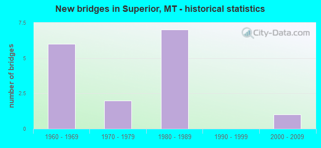
- New bridges - historical statistics
- 61960-1969
- 21970-1979
- 71980-1989
- 12000-2009


- Bridge Condition - Deck
- 50.0%Good
- 33.3%Satisfactory
- 8.3%Fair
- 8.3%Poor

- Bridge Condition - Superstructure
- 66.7%Good
- 16.7%Satisfactory
- 16.7%Fair

- Bridge Condition - Substructure
- 58.3%Good
- 33.3%Satisfactory
- 8.3%Fair

- Bridge Condition - Channel
- 12.5%Very good
- 37.5%Good
- 50.0%Satisfactory
Find on map >> Show street view
Structure Number: I00090042+03691, Location: 5M W SUPERIOR (Lat: 47.226039, Lng: -114.969797), Route carried "on" structure: Interstate 90, Year Built: 1983, Status: Open, Structure Length: 4.10m (13.45ft), Average Daily Traffic: 6,498 (year 2020), Truck Traffic: 28%, Average Future Daily Traffic: 6,823 (year 2040), Design Load: HS 20, Features Intersected: INT DRY CREEK
Minimum Vertical Clearance: 30+ m (98+ ft), Kilometerpoint: 67.984, Lanes on structure: 2, Lanes under structure: 2, Base Highway Network: Yes, Owner: State Highway Agency, Approaching Roadway Width: 12.8m (42.0ft), Material/Design: Prestressed concrete, Design/Construction: Stringer/Multi-beam, Number Of Spans In Main Unit: 3, Length of Maximum Span: 19.8m (65.0ft), Curb-To-Curb Width: 12.4m (40.7ft), Out-to-Out Width: 13.4m (44.0ft)
Condition: Deck: Good, Superstructure: Good, Substructure: Satisfactory, Operating Rating: 51.7 metric tons, Method Used To Determine Operating Rating: Load and Resistance Factor (LRFR), Inventory Rating: 32.7 metric tons, Method Used To Determine Inventory Rating: Load and Resistance Factor (LRFR), Structural Evaluation: Equal to present minimum criteria, Deck Geometry: Better than present minimum criteria, Underclear: Meets minimum limits, Approach Roadway Alignment: Equal to present desirable criteria, Designated Inspection Frequency: Every 48 months, Inspection Date: October 2021, Deck Structure Type: Concrete Cast-file-Place, Wearing Surface/Protective System: Wearing Surface: Epoxy Overlay
Find on map >> Show street view
Structure Number: I00090042+03692, Location: 5M W SUPERIOR (Lat: 47.226222, Lng: -114.969647), Route carried "on" structure: Interstate 90, Year Built: 1983, Status: Open, Structure Length: 4.10m (13.45ft), Average Daily Traffic: 6,498 (year 2020), Truck Traffic: 28%, Average Future Daily Traffic: 6,823 (year 2040), Design Load: HS 20, Features Intersected: INT DRY CREEK
Minimum Vertical Clearance: 30+ m (98+ ft), Kilometerpoint: 68.005, Lanes on structure: 2, Lanes under structure: 2, Base Highway Network: Yes, Owner: State Highway Agency, Approaching Roadway Width: 12.8m (42.0ft), Material/Design: Prestressed concrete, Design/Construction: Stringer/Multi-beam, Number Of Spans In Main Unit: 3, Length of Maximum Span: 19.8m (65.0ft), Curb-To-Curb Width: 12.4m (40.7ft), Out-to-Out Width: 13.4m (44.0ft)
Condition: Deck: Good, Superstructure: Good, Substructure: Satisfactory, Operating Rating: 50.8 metric tons, Method Used To Determine Operating Rating: Load and Resistance Factor (LRFR), Inventory Rating: 32.7 metric tons, Method Used To Determine Inventory Rating: Load and Resistance Factor (LRFR), Structural Evaluation: Equal to present minimum criteria, Deck Geometry: Better than present minimum criteria, Underclear: Meets minimum limits, Approach Roadway Alignment: Equal to present desirable criteria, Designated Inspection Frequency: Every 48 months, Inspection Date: October 2021, Deck Structure Type: Concrete Cast-file-Place, Wearing Surface/Protective System: Wearing Surface: Latex Concrete
Find on map >> Show street view
Structure Number: I00090042+09191, Location: 3.7M W SUPERIOR (Lat: 47.220761, Lng: -114.961200), Route carried "on" structure: Interstate 90, Year Built: 1982, Status: Open, Structure Length: 33.28m (109.19ft), Average Daily Traffic: 6,498 (year 2020), Truck Traffic: 28%, Average Future Daily Traffic: 6,823 (year 2040), Design Load: HL 93, Features Intersected: CLARK FORK RIVER
Minimum Vertical Clearance: 30+ m (98+ ft), Kilometerpoint: 68.861, Lanes on structure: 2, Base Highway Network: Yes, Owner: State Highway Agency, Approaching Roadway Width: 12.8m (42.0ft), Skew: 3 degrees, Material/Design: Steel continuous, Design/Construction: Stringer/Multi-beam, Number Of Spans In Main Unit: 6, Length of Maximum Span: 60.3m (197.8ft), Curb-To-Curb Width: 12.6m (41.3ft), Out-to-Out Width: 13.4m (44.0ft)
Condition: Deck: Satisfactory, Superstructure: Satisfactory, Substructure: Satisfactory, Channel: Satisfactory, Operating Rating: 43.5 metric tons, Method Used To Determine Operating Rating: Load and Resistance Factor (LRFR), Inventory Rating: 33.6 metric tons, Method Used To Determine Inventory Rating: Load and Resistance Factor (LRFR), Structural Evaluation: Equal to present minimum criteria, Deck Geometry: Better than present minimum criteria, Waterway Adequacy: Superior to present desirable criteria, Approach Roadway Alignment: Equal to present desirable criteria, Designated Inspection Frequency: Every 24 months, Underwater Inspection Frequency: Every 60 months, Inspection Date: June 2021, Underwater Inspection Date: August 2021, Deck Structure Type: Concrete Cast-file-Place, Wearing Surface/Protective System: Wearing Surface: Latex Concrete
Find on map >> Show street view
Structure Number: I00090042+09192, Location: 3.7M W SUPERIOR (Lat: 47.220917, Lng: -114.961197), Route carried "on" structure: Interstate 90, Year Built: 1984, Status: Open, Structure Length: 33.28m (109.19ft), Average Daily Traffic: 6,498 (year 2020), Truck Traffic: 28%, Average Future Daily Traffic: 6,823 (year 2040), Design Load: HL 93, Features Intersected: CLARK FORK RIVER
Minimum Vertical Clearance: 30+ m (98+ ft), Kilometerpoint: 68.876, Lanes on structure: 2, Base Highway Network: Yes, Owner: State Highway Agency, Approaching Roadway Width: 12.8m (42.0ft), Skew: 3 degrees, Material/Design: Steel continuous, Design/Construction: Stringer/Multi-beam, Number Of Spans In Main Unit: 6, Length of Maximum Span: 60.3m (197.8ft), Curb-To-Curb Width: 12.6m (41.3ft), Out-to-Out Width: 13.4m (44.0ft)
Condition: Deck: Poor, Superstructure: Fair, Substructure: Fair, Channel: Satisfactory, Operating Rating: 45.4 metric tons, Method Used To Determine Operating Rating: Load and Resistance Factor (LRFR), Inventory Rating: 35.4 metric tons, Method Used To Determine Inventory Rating: Load and Resistance Factor (LRFR), Structural Evaluation: Somewhat better than minimum adequacy, Deck Geometry: Better than present minimum criteria, Waterway Adequacy: Superior to present desirable criteria, Approach Roadway Alignment: Equal to present desirable criteria, Designated Inspection Frequency: Every 24 months, Underwater Inspection Frequency: Every 60 months, Inspection Date: June 2021, Underwater Inspection Date: August 2021, Deck Structure Type: Concrete Cast-file-Place, Wearing Surface/Protective System: Wearing Surface: Latex Concrete
Find on map >> Show street view
Structure Number: I00090045+01801, Location: 2.5M W SUPERIOR (Lat: 47.207936, Lng: -114.934975), Route carried "on" structure: Interstate 90, Year Built: 1976, Status: Open, Structure Length: 16.61m (54.49ft), Average Daily Traffic: 6,498 (year 2020), Truck Traffic: 28%, Average Future Daily Traffic: 6,823 (year 2040), Design Load: HS 20, Features Intersected: CLARK FORK RIVER
Minimum Vertical Clearance: 30+ m (98+ ft), Kilometerpoint: 71.384, Lanes on structure: 2, Base Highway Network: Yes, Owner: State Highway Agency, Approaching Roadway Width: 12.8m (42.0ft), Material/Design: Steel continuous, Design/Construction: Stringer/Multi-beam, Number Of Spans In Main Unit: 4, Length of Maximum Span: 54.9m (180.1ft), Curb-To-Curb Width: 12.6m (41.3ft), Out-to-Out Width: 13.5m (44.3ft)
Condition: Deck: Satisfactory, Superstructure: Satisfactory, Substructure: Satisfactory, Channel: Satisfactory, Operating Rating: 67.1 metric tons, Method Used To Determine Operating Rating: Load Factor (LF), Inventory Rating: 39.9 metric tons, Method Used To Determine Inventory Rating: Load Factor (LF), Structural Evaluation: Equal to present minimum criteria, Deck Geometry: Better than present minimum criteria, Waterway Adequacy: Superior to present desirable criteria, Approach Roadway Alignment: Equal to present desirable criteria, Designated Inspection Frequency: Every 24 months, Underwater Inspection Frequency: Every 60 months, Inspection Date: June 2021, Underwater Inspection Date: August 2021, Deck Structure Type: Concrete Cast-file-Place, Wearing Surface/Protective System: Wearing Surface: Latex Concrete
Find on map >> Show street view
Structure Number: I00090045+01802, Location: 2.5M W SUPERIOR (Lat: 47.207981, Lng: -114.934753), Route carried "on" structure: Interstate 90, Year Built: 1960, Year Reconstructed: 2012, Status: Open, Structure Length: 18.92m (62.07ft), Average Daily Traffic: 6,498 (year 2020), Truck Traffic: 28%, Average Future Daily Traffic: 6,823 (year 2040), Design Load: HS 20, Features Intersected: CLARK FORK RIVER
Minimum Vertical Clearance: 30+ m (98+ ft), Kilometerpoint: 71.417, Lanes on structure: 2, Base Highway Network: Yes, Owner: State Highway Agency, Approaching Roadway Width: 9.8m (32.2ft), Material/Design: Steel continuous, Design/Construction: Girder and Floorbeam System, Number Of Spans In Main Unit: 3, Number Of Approach Spans: 2, Length of Maximum Span: 54.9m (180.1ft), Curb-To-Curb Width: 8.3m (27.2ft), Out-to-Out Width: 9.2m (30.2ft)
Condition: Deck: Satisfactory, Superstructure: Fair, Substructure: Good, Channel: Satisfactory, Operating Rating: 56.2 metric tons, Method Used To Determine Operating Rating: Load Factor (LF), Inventory Rating: 33.6 metric tons, Method Used To Determine Inventory Rating: Load Factor (LF), Structural Evaluation: Somewhat better than minimum adequacy, Deck Geometry: High priority of replacement, Waterway Adequacy: Equal to present desirable criteria, Approach Roadway Alignment: Equal to present desirable criteria, Length Of Structure Improvement: 19.50m (63.98ft), Designated Inspection Frequency: Every 24 months, Critical Feature Inspection Frequency: Every 24 months, Underwater Inspection Frequency: Every 60 months, Inspection Date: June 2021, Critical Feature Inspection Date: June 2021, Underwater Inspection Date: August 2021, Bridge Improvement Cost: $1,169,000, Roadway Improvement Cost: $585,000, Total Project Cost: $1,754,000, Deck Structure Type: Concrete Cast-file-Place, Wearing Surface/Protective System: Wearing Surface: Monolithic Concrete, Deck Protection: Epoxy Coated Reinforcing
Find on map >> Show street view
Structure Number: I00090047+05521, Location: SUPERIOR (Lat: 47.192044, Lng: -114.891203), Route carried "on" structure: Interstate 90, Year Built: 1960, Status: Open, Structure Length: 4.69m (15.39ft), Average Daily Traffic: 6,415 (year 2020), Truck Traffic: 29%, Average Future Daily Traffic: 6,736 (year 2040), Design Load: HS 20, Features Intersected: INT SUPERIOR
Minimum Vertical Clearance: 30+ m (98+ ft), Kilometerpoint: 75.226, Lanes on structure: 2, Lanes under structure: 2, Base Highway Network: Yes, Owner: State Highway Agency, Approaching Roadway Width: 9.1m (29.9ft), Material/Design: Prestressed concrete, Design/Construction: Stringer/Multi-beam, Number Of Spans In Main Unit: 3, Length of Maximum Span: 18.6m (61.0ft), Curb-To-Curb Width: 8.5m (27.9ft), Out-to-Out Width: 9.0m (29.5ft)
Condition: Deck: Good, Superstructure: Good, Substructure: Good, Operating Rating: 44.5 metric tons, Method Used To Determine Operating Rating: Load and Resistance Factor (LRFR), Inventory Rating: 34.5 metric tons, Method Used To Determine Inventory Rating: Load and Resistance Factor (LRFR), Structural Evaluation: Better than present minimum criteria, Deck Geometry: High priority of replacement, Underclear: Somewhat better than minimum adequacy, Approach Roadway Alignment: Equal to present desirable criteria, Length Of Structure Improvement: 5.70m (18.70ft), Designated Inspection Frequency: Every 24 months, Inspection Date: April 2021, Bridge Improvement Cost: $270,000, Roadway Improvement Cost: $135,000, Total Project Cost: $405,000, Deck Structure Type: Concrete Cast-file-Place, Wearing Surface/Protective System: Wearing Surface: Latex Concrete
Find on map >> Show street view
Structure Number: I00090047+05522, Location: SUPERIOR (Lat: 47.192214, Lng: -114.891169), Route carried "on" structure: Interstate 90, Year Built: 1960, Status: Open, Structure Length: 4.69m (15.39ft), Average Daily Traffic: 6,415 (year 2020), Truck Traffic: 29%, Average Future Daily Traffic: 6,736 (year 2040), Design Load: HS 20, Features Intersected: INT SUPERIOR
Minimum Vertical Clearance: 30+ m (98+ ft), Kilometerpoint: 75.239, Lanes on structure: 2, Lanes under structure: 2, Base Highway Network: Yes, Owner: State Highway Agency, Approaching Roadway Width: 11.6m (38.1ft), Material/Design: Prestressed concrete, Design/Construction: Stringer/Multi-beam, Number Of Spans In Main Unit: 3, Length of Maximum Span: 18.6m (61.0ft), Curb-To-Curb Width: 8.5m (27.9ft), Out-to-Out Width: 9.0m (29.5ft)
Condition: Deck: Good, Superstructure: Good, Substructure: Good, Operating Rating: 44.5 metric tons, Method Used To Determine Operating Rating: Load and Resistance Factor (LRFR), Inventory Rating: 34.5 metric tons, Method Used To Determine Inventory Rating: Load and Resistance Factor (LRFR), Structural Evaluation: Better than present minimum criteria, Deck Geometry: High priority of replacement, Underclear: Somewhat better than minimum adequacy, Approach Roadway Alignment: Equal to present desirable criteria, Length Of Structure Improvement: 5.70m (18.70ft), Designated Inspection Frequency: Every 48 months, Inspection Date: April 2019, Bridge Improvement Cost: $270,000, Roadway Improvement Cost: $135,000, Total Project Cost: $405,000, Deck Structure Type: Concrete Cast-file-Place, Wearing Surface/Protective System: Wearing Surface: Latex Concrete
Find on map >> Show street view
Structure Number: L31007002+05101, Location: SUPERIOR-RIVER ST N (Lat: 47.196264, Lng: -114.890803), Route carried "on" structure: ServiceState highway 31007, Year Built: 1972, Status: Open, Structure Length: 13.32m (43.70ft), Average Daily Traffic: 1,773 (year 2020), Truck Traffic: 3%, Average Future Daily Traffic: 1,862 (year 2040), Design Load: HS 20, Features Intersected: CLARK FORK 003, Facility Carried by Structure: RIVER ST N
Minimum Vertical Clearance: 30+ m (98+ ft), Kilometerpoint: 0.475, Lanes on structure: 2, Owner: State Highway Agency, Approaching Roadway Width: 13.3m (43.6ft), Material/Design: Steel continuous, Design/Construction: Stringer/Multi-beam, Number Of Spans In Main Unit: 4, Length of Maximum Span: 36.6m (120.1ft), Curb or Sidewalk Widths: Left: 1.7m (5.6ft), Right: 1.7m (5.6ft), Curb-To-Curb Width: 9.1m (29.9ft), Out-to-Out Width: 13.3m (43.6ft)
Condition: Deck: Fair, Superstructure: Good, Substructure: Good, Channel: Good, Operating Rating: 44.5 metric tons, Method Used To Determine Operating Rating: Load and Resistance Factor (LRFR), Inventory Rating: 34.5 metric tons, Method Used To Determine Inventory Rating: Load and Resistance Factor (LRFR), Structural Evaluation: Better than present minimum criteria, Deck Geometry: Somewhat better than minimum adequacy, Waterway Adequacy: Superior to present desirable criteria, Approach Roadway Alignment: Equal to present desirable criteria, Designated Inspection Frequency: Every 24 months, Underwater Inspection Frequency: Every 60 months, Inspection Date: July 2021, Underwater Inspection Date: August 2021, Deck Structure Type: Concrete Cast-file-Place, Wearing Surface/Protective System: Wearing Surface: Monolithic Concrete
Find on map >> Show street view
Structure Number: L31073000+01001, Location: 4M S SUPERIOR (Lat: 47.157189, Lng: -114.910747), Route carried "on" structure: County highway 31073, Year Built: 2005, Status: Open, Structure Length: 1.98m (6.50ft), Average Daily Traffic: 100 (year 2022), Truck Traffic: 3%, Average Future Daily Traffic: 100 (year 2037), Design Load: HS 20, Features Intersected: CEDAR CREEK 051, Facility Carried by Structure: UPHAM GULCH RD
Minimum Vertical Clearance: 30+ m (98+ ft), Kilometerpoint: 4.377, Lanes on structure: 1, Owner: County Highway Agency, Approaching Roadway Width: 3.3m (10.8ft), Material/Design: Prestressed concrete, Design/Construction: Tee Beam, Number Of Spans In Main Unit: 1, Length of Maximum Span: 19.8m (65.0ft), Curb-To-Curb Width: 4.2m (13.8ft), Out-to-Out Width: 4.8m (15.7ft)
Condition: Deck: Good, Superstructure: Good, Substructure: Good, Channel: Good, Operating Rating: 36.3 metric tons, Method Used To Determine Operating Rating: Load and Resistance Factor (LRFR), Inventory Rating: 22.7 metric tons, Method Used To Determine Inventory Rating: Load and Resistance Factor (LRFR), Structural Evaluation: Equal to present minimum criteria, Deck Geometry: Somewhat better than minimum adequacy, Waterway Adequacy: Better than present minimum criteria, Approach Roadway Alignment: Meets minimum limits, Designated Inspection Frequency: Every 24 months, Inspection Date: April 2021, Deck Structure Type: Concrete Precast Panels
Find on map >> Show street view
Structure Number: L31169000+01001, Location: N DRY CREEK INT (Lat: 47.228756, Lng: -114.965928), Route carried "on" structure: ServiceState highway 31169, Year Built: 1982, Status: Open, Structure Length: 13.09m (42.95ft), Average Daily Traffic: 100 (year 2022), Truck Traffic: 3%, Average Future Daily Traffic: 100 (year 2037), Design Load: HS 20, Features Intersected: CLARK FORK 015, Facility Carried by Structure: SOUTHSIDE CROSSING
Minimum Vertical Clearance: 30+ m (98+ ft), Kilometerpoint: 0.077, Lanes on structure: 2, Owner: State Highway Agency, Approaching Roadway Width: 9.4m (30.8ft), Material/Design: Steel continuous, Design/Construction: Stringer/Multi-beam, Number Of Spans In Main Unit: 3, Length of Maximum Span: 49.7m (163.1ft), Curb-To-Curb Width: 9.5m (31.2ft), Out-to-Out Width: 10.5m (34.4ft)
Condition: Deck: Good, Superstructure: Good, Substructure: Good, Channel: Good, Operating Rating: 23.6 metric tons, Method Used To Determine Operating Rating: Load and Resistance Factor (LRFR), Inventory Rating: 18.1 metric tons, Method Used To Determine Inventory Rating: Load and Resistance Factor (LRFR), Structural Evaluation: Somewhat better than minimum adequacy, Deck Geometry: Better than present minimum criteria, Waterway Adequacy: Superior to present desirable criteria, Approach Roadway Alignment: Equal to present desirable criteria, Designated Inspection Frequency: Every 24 months, Underwater Inspection Frequency: Every 60 months, Inspection Date: July 2021, Underwater Inspection Date: September 2018, Deck Structure Type: Concrete Cast-file-Place, Wearing Surface/Protective System: Wearing Surface: Monolithic Concrete
Find on map >> Show street view
Structure Number: L31169000+07001, Location: 5M W SUPERIOR (Lat: 47.221256, Lng: -114.973119), Route carried "on" structure: County highway 31169, Year Built: 1962, Status: Open, Structure Length: 1.37m (4.49ft), Average Daily Traffic: 100 (year 2022), Truck Traffic: 3%, Average Future Daily Traffic: 100 (year 2037), Features Intersected: DRY CREEK 002, Facility Carried by Structure: SOUTHSIDE RD
Minimum Vertical Clearance: 30+ m (98+ ft), Kilometerpoint: 1.119, Lanes on structure: 2, Owner: County Highway Agency, Approaching Roadway Width: 6.4m (21.0ft), Skew: 4 degrees, Material/Design: Wood or Timber, Design/Construction: Stringer/Multi-beam, Number Of Spans In Main Unit: 1, Length of Maximum Span: 13.1m (43.0ft), Curb or Sidewalk Widths: Left: 0.2m (0.7ft), Right: 0.2m (0.7ft), Curb-To-Curb Width: 6.9m (22.6ft), Out-to-Out Width: 7.2m (23.6ft)
Condition: Deck: Satisfactory, Superstructure: Good, Substructure: Good, Channel: Very good, Operating Rating: 34.5 metric tons, Method Used To Determine Operating Rating: Allowable Stress (AS), Inventory Rating: 23.6 metric tons, Method Used To Determine Inventory Rating: Allowable Stress (AS), Structural Evaluation: Equal to present minimum criteria, Deck Geometry: Somewhat better than minimum adequacy, Waterway Adequacy: Equal to present desirable criteria, Approach Roadway Alignment: Equal to present desirable criteria, Bridge Posting: Required (Relationship of Operating Rating to Maximum Legal Load: 0.1 - 9.9% below), Designated Inspection Frequency: Every 24 months, Inspection Date: November 2021, Deck Structure Type: Wood or Timber, Wearing Surface/Protective System: Wearing Surface: Bituminous
Find on map >> Show street view
Structure Number: I00090042+03691, Location: 5M W SUPERIOR (Lat: 47.226039, Lng: -114.969797), Route carried "under" structure: ServiceCounty highway 31169, Year Built: 1983, Structure Length: 0. m, Average Daily Traffic: 100 (year 2022), Truck Traffic: 3%, Features Intersected: INT DRY CREEK, Facility Carried by Structure: I 90
Minimum Vertical Clearance: 4.95m (16.24ft), Kilometerpoint: 0.504, Lanes on structure: 2, Lanes under structure: 2, Material/Design: Prestressed concrete, Design/Construction: Stringer/Multi-beam, Length of Maximum Span: 19.8m (65.0ft)
Find on map >> Show street view
Structure Number: I00090042+03692, Location: 5M W SUPERIOR (Lat: 47.226222, Lng: -114.969647), Route carried "under" structure: ServiceCounty highway 31169, Year Built: 1983, Structure Length: 0. m, Average Daily Traffic: 100 (year 2022), Truck Traffic: 3%, Features Intersected: INT DRY CREEK, Facility Carried by Structure: I 90
Minimum Vertical Clearance: 5.00m (16.40ft), Kilometerpoint: 0.481, Lanes on structure: 2, Lanes under structure: 2, Material/Design: Prestressed concrete, Design/Construction: Stringer/Multi-beam, Length of Maximum Span: 19.8m (65.0ft)
Find on map >> Show street view
Structure Number: I00090047+05521, Location: SUPERIOR (Lat: 47.192044, Lng: -114.891203), Route carried "under" structure: County highway 31007, Year Built: 1960, Structure Length: 0. m, Average Daily Traffic: 2,938 (year 2020), Truck Traffic: 3%, Features Intersected: INT SUPERIOR, Facility Carried by Structure: I 90
Minimum Vertical Clearance: 4.75m (15.58ft), Kilometerpoint: 0.000, Lanes on structure: 2, Lanes under structure: 2, Material/Design: Prestressed concrete, Design/Construction: Stringer/Multi-beam, Length of Maximum Span: 18.6m (61.0ft)
Find on map >> Show street view
Structure Number: I00090047+05522, Location: SUPERIOR (Lat: 47.192214, Lng: -114.891169), Route carried "under" structure: ServiceCounty highway 31007, Year Built: 1960, Structure Length: 0. m, Average Daily Traffic: 2,938 (year 2020), Truck Traffic: 3%, Features Intersected: INT SUPERIOR, Facility Carried by Structure: I 90
Minimum Vertical Clearance: 4.95m (16.24ft), Kilometerpoint: 0.019, Lanes on structure: 2, Lanes under structure: 2, Material/Design: Prestressed concrete, Design/Construction: Stringer/Multi-beam, Length of Maximum Span: 18.6m (61.0ft)