Bridge Statistics for Susan Moore, Alabama (AL)
Condition, Traffic, Stress, Structural Evaluation, Project Costs
- National Bridge Inventory (NBI) Statistics
- 11Number of bridges
- 157ft / 47.9mTotal length
- $10,858,000Total costs
- 4,052Total average daily traffic
- 142Total average daily truck traffic
- 6,020Total future (year 2035) average daily traffic
- National Bridge Inventory (NBI) Registered Bridges for Susan Moore
- No street view available for this location
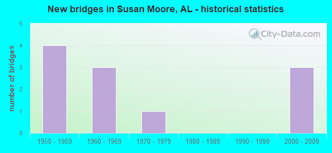
- New bridges - historical statistics
- 41950-1959
- 31960-1969
- 11970-1979
- 32000-2009

- Bridge Condition - Deck
- 12.5%Very good
- 25.0%Good
- 37.5%Satisfactory
- 25.0%Fair

- Bridge Condition - Superstructure
- 12.5%Very good
- 37.5%Satisfactory
- 25.0%Fair
- 12.5%Poor
- 12.5%Serious

- Bridge Condition - Substructure
- 12.5%Very good
- 12.5%Good
- 12.5%Satisfactory
- 37.5%Fair
- 12.5%Poor
- 12.5%Imminent failure

- Bridge Condition - Channel
- 27.3%Very good
- 18.2%Satisfactory
- 54.5%Fair

- Bridge Condition - Culverts
- 33.3%Good
- 33.3%Satisfactory
- 33.3%Fair
Find on map >> Show street view
Structure Number: 4814, Location: RIVERSIDE (Lat: 34.067897, Lng: -86.494278), Route carried "on" structure: County highway 26, Year Built: 1954, Status: Posted for load, Structure Length: 11.80m (38.71ft), Average Daily Traffic: 1,188 (year 2021), Truck Traffic: 8%, Average Future Daily Traffic: 1,766 (year 2041), Design Load: H 15, Features Intersected: LOCUST FORK RIVER
Minimum Vertical Clearance: 30+ m (98+ ft), Kilometerpoint: 0.010, Lanes on structure: 2, Owner: County Highway Agency, Approaching Roadway Width: 8.5m (27.9ft), Material/Design: Steel continuous, Design/Construction: Girder and Floorbeam System, Number Of Spans In Main Unit: 3, Number Of Approach Spans: 3, Length of Maximum Span: 30.5m (100.1ft), Curb-To-Curb Width: 6.7m (22.0ft), Out-to-Out Width: 7.7m (25.3ft)
Condition: Deck: Satisfactory, Superstructure: Satisfactory, Substructure: Satisfactory, Channel: Fair, Operating Rating: 31.1 metric tons, Method Used To Determine Operating Rating: Allowable Stress (AS), Inventory Rating: 17.2 metric tons, Method Used To Determine Inventory Rating: Allowable Stress (AS), Structural Evaluation: Meets minimum limits, Deck Geometry: High priority of corrective action, Waterway Adequacy: Equal to present desirable criteria, Approach Roadway Alignment: Equal to present desirable criteria, Bridge Posting: Required (Relationship of Operating Rating to Maximum Legal Load: 20.0 - 29.9% below), Length Of Structure Improvement: 12.66m (41.54ft), Designated Inspection Frequency: Every 24 months, Other Special Inspection Frequency: Every 12 months, Inspection Date: June 2021, Other Special Inspection Date: June 2021, Bridge Improvement Cost: $2,170,000, Roadway Improvement Cost: $217,000, Total Project Cost: $2,387,000 ( Estimate for 2022), Deck Structure Type: Concrete Cast-file-Place
Find on map >> Show street view
Structure Number: 5677, Location: 1 1/2 MI E OF WYNNVILE (Lat: 34.081697, Lng: -86.371817), Route carried "on" structure: County highway 275, Year Built: 1956, Status: Closed, Structure Length: 1.37m (4.49ft), Average Daily Traffic: 66 (year 2015), Average Future Daily Traffic: 98 (year 2035), Features Intersected: WHIPPOORWILL CREEK, Facility Carried by Structure: GAINES ROAD
Minimum Vertical Clearance: 30+ m (98+ ft), Kilometerpoint: 0.010, Lanes on structure: 1, Owner: County Highway Agency, Approaching Roadway Width: 4.3m (14.1ft), Material/Design: Steel, Design/Construction: Stringer/Multi-beam, Number Of Spans In Main Unit: 1, Length of Maximum Span: 13.7m (44.9ft), Curb-To-Curb Width: 3.4m (11.2ft), Out-to-Out Width: 3.7m (12.1ft)
Condition: Deck: Fair, Superstructure: Fair, Substructure: Fair, Channel: Fair, Deck Geometry: High priority of corrective action, Waterway Adequacy: Equal to present minimum criteria, Approach Roadway Alignment: High priority of replacement, Bridge Posting: Required (Relationship of Operating Rating to Maximum Legal Load: > 39.9% below), Length Of Structure Improvement: 2.04m (6.69ft), Designated Inspection Frequency: Every 24 months, Other Special Inspection Frequency: Every 12 months, Inspection Date: January 2015, Other Special Inspection Date: December 2015, Bridge Improvement Cost: $168,000, Roadway Improvement Cost: $17,000, Total Project Cost: $185,000 ( Estimate for 2022), Deck Structure Type: Wood or Timber, Wearing Surface/Protective System: Wearing Surface: Wood or Timber
Find on map >> Show street view
Structure Number: 6419, Location: 1 MI N OF SUSAN MOORE (Lat: 34.093044, Lng: -86.421706), Route carried "on" structure: City street 297, Year Built: 1958, Status: Posted for load, Structure Length: 0.82m (2.69ft), Average Daily Traffic: 225 (year 2017), Truck Traffic: 3%, Average Future Daily Traffic: 334 (year 2037), Features Intersected: DRY CREEK, Facility Carried by Structure: RIDGEWAY ROAD
Minimum Vertical Clearance: 30+ m (98+ ft), Kilometerpoint: 0.010, Lanes on structure: 2, Owner: City or Municipal Highway Agency, Approaching Roadway Width: 6.3m (20.7ft), Material/Design: Steel, Design/Construction: Stringer/Multi-beam, Number Of Spans In Main Unit: 2, Length of Maximum Span: 4.6m (15.1ft), Curb-To-Curb Width: 6.1m (20.0ft), Out-to-Out Width: 6.4m (21.0ft)
Condition: Deck: Fair, Superstructure: Poor, Substructure: Poor, Channel: Fair, Operating Rating: 23.7 metric tons, Method Used To Determine Operating Rating: Load Factor (LF), Inventory Rating: 14.2 metric tons, Method Used To Determine Inventory Rating: Load Factor (LF), Structural Evaluation: Meets minimum limits, Waterway Adequacy: Meets minimum limits, Approach Roadway Alignment: Meets minimum limits, Bridge Posting: Required (Relationship of Operating Rating to Maximum Legal Load: > 39.9% below), Length Of Structure Improvement: 1.48m (4.86ft), Designated Inspection Frequency: Every 24 months, Other Special Inspection Frequency: Every 12 months, Inspection Date: November 2021, Other Special Inspection Date: November 2021, Bridge Improvement Cost: $214,000, Roadway Improvement Cost: $21,000, Total Project Cost: $235,000 ( Estimate for 2022), Deck Structure Type: Concrete Cast-file-Place, Wearing Surface/Protective System: Wearing Surface: Bituminous
Find on map >> Show street view
Structure Number: 8045, Location: 1 MI N OF SUSAN MOORE (Lat: 34.101003, Lng: -86.438567), Route carried "on" structure: County highway 80, Year Built: 1963, Status: Posted for load, Structure Length: 10.97m (35.99ft), Average Daily Traffic: 249 (year 2021), Truck Traffic: 3%, Average Future Daily Traffic: 369 (year 2041), Design Load: H 15, Features Intersected: LOCUST FORK RIVER, Facility Carried by Structure: PAINTER ROAD
Minimum Vertical Clearance: 30+ m (98+ ft), Kilometerpoint: 0.010, Lanes on structure: 2, Owner: County Highway Agency, Approaching Roadway Width: 7.8m (25.6ft), Material/Design: Steel, Design/Construction: Stringer/Multi-beam, Number Of Spans In Main Unit: 3, Number Of Approach Spans: 5, Length of Maximum Span: 24.4m (80.1ft), Curb-To-Curb Width: 6.6m (21.7ft), Out-to-Out Width: 7.2m (23.6ft)
Condition: Deck: Satisfactory, Superstructure: Satisfactory, Substructure: Fair, Channel: Satisfactory, Operating Rating: 28.2 metric tons, Method Used To Determine Operating Rating: Load Factor (LF), Inventory Rating: 10.3 metric tons, Method Used To Determine Inventory Rating: Load Factor (LF), Structural Evaluation: High priority of replacement, Deck Geometry: Meets minimum limits, Waterway Adequacy: Better than present minimum criteria, Approach Roadway Alignment: Somewhat better than minimum adequacy, Bridge Posting: Required (Relationship of Operating Rating to Maximum Legal Load: 20.0 - 29.9% below), Length Of Structure Improvement: 11.86m (38.91ft), Designated Inspection Frequency: Every 24 months, Other Special Inspection Frequency: Every 12 months, Inspection Date: June 2021, Other Special Inspection Date: June 2021, Bridge Improvement Cost: $1,871,000, Roadway Improvement Cost: $187,000, Total Project Cost: $2,058,000 ( Estimate for 2022), Deck Structure Type: Concrete Cast-file-Place
Find on map >> Show street view
Structure Number: 919, Location: 1 MI E OF HENDRIX (Lat: 34.042200, Lng: -86.440500), Route carried "on" structure: County highway 284, Year Built: 1966, Status: Posted for load, Structure Length: 0.91m (2.99ft), Average Daily Traffic: 136 (year 2021), Truck Traffic: 1%, Average Future Daily Traffic: 203 (year 2041), Features Intersected: JONES CREEK, Facility Carried by Structure: PROMISE LANE
Minimum Vertical Clearance: 30+ m (98+ ft), Kilometerpoint: 0.010, Lanes on structure: 1, Owner: County Highway Agency, Approaching Roadway Width: 6.0m (19.7ft), Skew: 1 degrees, Material/Design: Steel, Design/Construction: Stringer/Multi-beam, Number Of Spans In Main Unit: 1, Length of Maximum Span: 9.1m (29.9ft), Curb-To-Curb Width: 3.4m (11.2ft), Out-to-Out Width: 5.6m (18.4ft)
Condition: Deck: Good, Superstructure: Fair, Substructure: Fair, Channel: Fair, Operating Rating: 36.3 metric tons, Method Used To Determine Operating Rating: Load Factor (LF), Inventory Rating: 21.7 metric tons, Method Used To Determine Inventory Rating: Load Factor (LF), Structural Evaluation: Somewhat better than minimum adequacy, Deck Geometry: High priority of replacement, Waterway Adequacy: Somewhat better than minimum adequacy, Approach Roadway Alignment: Meets minimum limits, Bridge Posting: Required (Relationship of Operating Rating to Maximum Legal Load: 10.0 - 19.9% below), Length Of Structure Improvement: 1.59m (5.22ft), Designated Inspection Frequency: Every 24 months, Other Special Inspection Frequency: Every 12 months, Inspection Date: January 2021, Other Special Inspection Date: January 2022, Bridge Improvement Cost: $196,000, Roadway Improvement Cost: $20,000, Total Project Cost: $216,000 ( Estimate for 2022), Deck Structure Type: Concrete Cast-file-Place
Find on map >> Show street view
Structure Number: 9417, Location: 3 MI NE OF RIVERSIDE (Lat: 34.099339, Lng: -86.468108), Route carried "on" structure: County highway 38, Year Built: 1967, Status: Open, Structure Length: 0.61m (2.00ft), Average Daily Traffic: 336 (year 2021), Truck Traffic: 5%, Average Future Daily Traffic: 499 (year 2041), Design Load: H 15, Features Intersected: HONEY BRANCH, Facility Carried by Structure: WMS SETTLEMENT RD
Minimum Vertical Clearance: 30+ m (98+ ft), Kilometerpoint: 0.010, Lanes on structure: 2, Owner: County Highway Agency, Approaching Roadway Width: 10.1m (33.1ft), Material/Design: Concrete, Design/Construction: Culvert, Number Of Spans In Main Unit: 2, Length of Maximum Span: 3.0m (9.8ft)
Condition: Channel: Fair, Culverts: Fair, Operating Rating: 88.9 metric tons, Method Used To Determine Operating Rating: Load Factor (LF), Inventory Rating: 69.8 metric tons, Method Used To Determine Inventory Rating: Load Factor (LF), Structural Evaluation: Somewhat better than minimum adequacy, Waterway Adequacy: Somewhat better than minimum adequacy, Approach Roadway Alignment: Equal to present desirable criteria, Length Of Structure Improvement: 1.22m (4.00ft), Designated Inspection Frequency: Every 24 months, Inspection Date: Febuary 2021, Bridge Improvement Cost: $352,000, Roadway Improvement Cost: $35,000, Total Project Cost: $387,000 ( Estimate for 2022)
Find on map >> Show street view
Structure Number: 11326, Location: 2 MI SW OF SNEAD (Lat: 34.105381, Lng: -86.412075), Route carried "on" structure: City street 299, Year Built: 1958, Year Reconstructed: 1975, Status: Closed, Structure Length: 3.26m (10.70ft), Average Daily Traffic: 184 (year 2017), Average Future Daily Traffic: 274 (year 2037), Features Intersected: WHIPPOORWILL CREEK, Facility Carried by Structure: MOORE ROAD
Minimum Vertical Clearance: 30+ m (98+ ft), Kilometerpoint: 0.010, Lanes on structure: 1, Owner: City or Municipal Highway Agency, Approaching Roadway Width: 4.9m (16.1ft), Material/Design: Steel, Design/Construction: Stringer/Multi-beam, Number Of Spans In Main Unit: 3, Length of Maximum Span: 15.2m (49.9ft), Curb-To-Curb Width: 4.0m (13.1ft), Out-to-Out Width: 4.3m (14.1ft)
Condition: Deck: Satisfactory, Superstructure: Serious, Substructure: Imminent failure, Channel: Fair, Waterway Adequacy: Better than present minimum criteria, Approach Roadway Alignment: High priority of replacement, Bridge Posting: Required (Relationship of Operating Rating to Maximum Legal Load: > 39.9% below), Length Of Structure Improvement: 4.13m (13.55ft), Designated Inspection Frequency: Every 24 months, Other Special Inspection Frequency: Every 3 months, Inspection Date: Febuary 2020, Other Special Inspection Date: November 2019, Bridge Improvement Cost: $397,000, Roadway Improvement Cost: $40,000, Total Project Cost: $437,000 ( Estimate for 2022), Deck Structure Type: Wood or Timber, Wearing Surface/Protective System: Wearing Surface: Wood or Timber
Find on map >> Show street view
Structure Number: 12209, Location: 2 1/2 MI W OF SNEAD CROSS (Lat: 34.114350, Lng: -86.438744), Route carried "on" structure: County highway 14, Year Built: 1979, Status: Open, Structure Length: 9.60m (31.50ft), Average Daily Traffic: 405 (year 2021), Truck Traffic: 2%, Average Future Daily Traffic: 601 (year 2041), Design Load: HS 20, Features Intersected: LOCUST FORK RIVER
Minimum Vertical Clearance: 30+ m (98+ ft), Kilometerpoint: 0.010, Lanes on structure: 2, Owner: County Highway Agency, Approaching Roadway Width: 9.8m (32.2ft), Material/Design: Steel continuous, Design/Construction: Girder and Floorbeam System, Number Of Spans In Main Unit: 3, Number Of Approach Spans: 1, Length of Maximum Span: 30.5m (100.1ft), Curb-To-Curb Width: 8.5m (27.9ft), Out-to-Out Width: 9.1m (29.9ft)
Condition: Deck: Good, Superstructure: Satisfactory, Substructure: Good, Channel: Satisfactory, Operating Rating: 39.9 metric tons, Method Used To Determine Operating Rating: Allowable Stress (AS), Inventory Rating: 24.5 metric tons, Method Used To Determine Inventory Rating: Allowable Stress (AS), Structural Evaluation: Equal to present minimum criteria, Deck Geometry: Somewhat better than minimum adequacy, Waterway Adequacy: Superior to present desirable criteria, Approach Roadway Alignment: Equal to present desirable criteria, Length Of Structure Improvement: 10.55m (34.61ft), Designated Inspection Frequency: Every 24 months, Inspection Date: June 2021, Bridge Improvement Cost: $2,097,000, Roadway Improvement Cost: $210,000, Total Project Cost: $2,307,000 ( Estimate for 2022), Deck Structure Type: Concrete Cast-file-Place
Find on map >> Show street view
Structure Number: 1837, Location: 1/2 MI E OF WYNNVILLE (Lat: 34.079425, Lng: -86.385214), Route carried "on" structure: County highway 302, Year Built: 2003, Status: Open, Structure Length: 0.88m (2.89ft), Average Daily Traffic: 666 (year 2020), Average Future Daily Traffic: 989 (year 2040), Design Load: HS 20, Features Intersected: PARKER BRANCH, Facility Carried by Structure: LECROY DRIVE
Minimum Vertical Clearance: 30+ m (98+ ft), Kilometerpoint: 0.016, Lanes on structure: 2, Owner: County Highway Agency, Approaching Roadway Width: 9.1m (29.9ft), Material/Design: Concrete, Design/Construction: Culvert, Number Of Spans In Main Unit: 2, Length of Maximum Span: 4.3m (14.1ft), Curb-To-Curb Width: 9.1m (29.9ft), Out-to-Out Width: 10.1m (33.1ft)
Condition: Channel: Very good, Culverts: Good, Operating Rating: 41.7 metric tons, Method Used To Determine Operating Rating: Load Factor (LF), Inventory Rating: 25.0 metric tons, Method Used To Determine Inventory Rating: Load Factor (LF), Structural Evaluation: Equal to present minimum criteria, Deck Geometry: Equal to present minimum criteria, Waterway Adequacy: Superior to present desirable criteria, Approach Roadway Alignment: Superior to present desirable criteria, Length Of Structure Improvement: 1.54m (5.05ft), Designated Inspection Frequency: Every 24 months, Inspection Date: August 2020, Bridge Improvement Cost: $303,000, Roadway Improvement Cost: $30,000, Total Project Cost: $333,000 ( Estimate for 2022), Wearing Surface/Protective System: Wearing Surface: Bituminous
Find on map >> Show street view
Structure Number: 18372, Location: 1.5 MI. SOUTH OF SNEAD (Lat: 34.085100, Lng: -86.383581), Route carried "on" structure: County highway 296, Year Built: 2004, Status: Open, Structure Length: 6.10m (20.01ft), Average Daily Traffic: 366 (year 2021), Truck Traffic: 2%, Average Future Daily Traffic: 544 (year 2041), Design Load: HS 20, Features Intersected: WHIPPOORWILL CREEK, Facility Carried by Structure: WYNNVILLE ROAD
Minimum Vertical Clearance: 30+ m (98+ ft), Kilometerpoint: 0.016, Lanes on structure: 2, Owner: County Highway Agency, Approaching Roadway Width: 11.3m (37.1ft), Material/Design: Prestressed concrete, Design/Construction: Stringer/Multi-beam, Number Of Spans In Main Unit: 4, Length of Maximum Span: 15.2m (49.9ft), Curb-To-Curb Width: 9.8m (32.2ft), Out-to-Out Width: 10.6m (34.8ft)
Condition: Deck: Very good, Superstructure: Very good, Substructure: Very good, Channel: Very good, Operating Rating: 56.5 metric tons, Method Used To Determine Operating Rating: Load Factor (LF), Inventory Rating: 33.8 metric tons, Method Used To Determine Inventory Rating: Load Factor (LF), Structural Evaluation: Equal to present desirable criteria, Deck Geometry: Better than present minimum criteria, Waterway Adequacy: Superior to present desirable criteria, Approach Roadway Alignment: Equal to present minimum criteria, Length Of Structure Improvement: 7.14m (23.43ft), Designated Inspection Frequency: Every 24 months, Inspection Date: June 2021, Bridge Improvement Cost: $1,663,000, Roadway Improvement Cost: $166,000, Total Project Cost: $1,829,000 ( Estimate for 2022), Deck Structure Type: Concrete Cast-file-Place
Find on map >> Show street view
Structure Number: 18486, Location: 1/2 MI S OF HENDRIX (Lat: 34.031086, Lng: -86.453697), Route carried "on" structure: County highway 289, Year Built: 2003, Status: Open, Structure Length: 1.56m (5.12ft), Average Daily Traffic: 231 (year 2020), Truck Traffic: 1%, Average Future Daily Traffic: 343 (year 2040), Design Load: HS 20, Features Intersected: JONES CREEK, Facility Carried by Structure: KING ROAD
Minimum Vertical Clearance: 30+ m (98+ ft), Kilometerpoint: 0.016, Lanes on structure: 2, Owner: County Highway Agency, Approaching Roadway Width: 9.1m (29.9ft), Skew: 1 degrees, Material/Design: Concrete, Design/Construction: Culvert, Number Of Spans In Main Unit: 3, Length of Maximum Span: 4.9m (16.1ft), Curb-To-Curb Width: 9.5m (31.2ft), Out-to-Out Width: 10.4m (34.1ft)
Condition: Channel: Very good, Culverts: Satisfactory, Operating Rating: 54.9 metric tons, Method Used To Determine Operating Rating: Load Factor (LF), Inventory Rating: 32.9 metric tons, Method Used To Determine Inventory Rating: Load Factor (LF), Structural Evaluation: Equal to present minimum criteria, Deck Geometry: Equal to present minimum criteria, Waterway Adequacy: Superior to present desirable criteria, Approach Roadway Alignment: Equal to present desirable criteria, Length Of Structure Improvement: 2.24m (7.35ft), Designated Inspection Frequency: Every 24 months, Inspection Date: June 2020, Bridge Improvement Cost: $440,000, Roadway Improvement Cost: $44,000, Total Project Cost: $484,000 ( Estimate for 2022)