Bridge Statistics for Sutherland, Nebraska (NE)
Condition, Traffic, Stress, Structural Evaluation, Project Costs
- National Bridge Inventory (NBI) Statistics
- 26Number of bridges
- 312ft / 95.0mTotal length
- 107,175Total average daily traffic
- 41,728Total average daily truck traffic
- National Bridge Inventory (NBI) Registered Bridges for Sutherland
- No street view available for this location
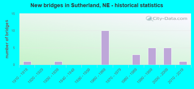
- New bridges - historical statistics
- 11910-1919
- 11930-1939
- 101960-1969
- 31980-1989
- 51990-1999
- 52000-2009
- 12010-2019


- Bridge Condition - Deck
- 33.3%Very good
- 33.3%Good
- 16.7%Satisfactory
- 16.7%Fair

- Bridge Condition - Superstructure
- 41.7%Very good
- 41.7%Good
- 16.7%Fair

- Bridge Condition - Substructure
- 33.3%Very good
- 50.0%Good
- 8.3%Fair
- 8.3%Poor

- Bridge Condition - Channel
- 25.0%Excellent
- 33.3%Very good
- 16.7%Good
- 16.7%Satisfactory
- 8.3%Fair

- Bridge Condition - Culverts
- 33.3%Very good
- 66.7%Good
Find on map >> Show street view
Structure Number: C005602205, Location: 4.5N 3E OF SUTHERLAND (Lat: 41.221500, Lng: -101.070000), Route carried "on" structure: County highway 7304, Year Built: 2005, Status: Open, Structure Length: 2.50m (8.20ft), Average Daily Traffic: 40 (year 1998), Average Future Daily Traffic: 40 (year 2033), Design Load: HS 20, Features Intersected: BIRDWOOD CREEK
Minimum Vertical Clearance: 30+ m (98+ ft), Kilometerpoint: 0.486, Lanes on structure: 2, Owner: County Highway Agency, Approaching Roadway Width: 8.5m (27.9ft), Skew: 1 degrees, Material/Design: Steel, Design/Construction: Stringer/Multi-beam, Number Of Spans In Main Unit: 1, Length of Maximum Span: 24.4m (80.1ft), Curb-To-Curb Width: 8.5m (27.9ft), Out-to-Out Width: 9.3m (30.5ft)
Condition: Deck: Very good, Superstructure: Good, Substructure: Good, Channel: Very good, Operating Rating: 57.0 metric tons, Method Used To Determine Operating Rating: Load Factor (LF), Inventory Rating: 34.0 metric tons, Method Used To Determine Inventory Rating: Load Factor (LF), Structural Evaluation: Better than present minimum criteria, Deck Geometry: Better than present minimum criteria, Waterway Adequacy: Superior to present desirable criteria, Approach Roadway Alignment: Equal to present desirable criteria, Length Of Structure Improvement: 1.83m (6.00ft), Designated Inspection Frequency: Every 24 months, Inspection Date: November 2020, Deck Structure Type: Concrete Cast-file-Place, Wearing Surface/Protective System: Wearing Surface: Monolithic Concrete
Find on map >> Show street view
Structure Number: C005603205, Location: 1N .4E OF SUTHERLAND (Lat: 41.178300, Lng: -101.106700), Route carried "on" structure: County highway 32, Year Built: 1986, Status: Open, Structure Length: 0.82m (2.69ft), Average Daily Traffic: 100 (year 2003), Truck Traffic: 10%, Average Future Daily Traffic: 170 (year 2033), Design Load: H 20, Features Intersected: NORTH PLATTE CANAL, Facility Carried by Structure: COUNTY HIGHWAY
Minimum Vertical Clearance: 30+ m (98+ ft), Kilometerpoint: 0.000, Lanes on structure: 2, Owner: County Highway Agency, Approaching Roadway Width: 7.3m (24.0ft), Skew: 2 degrees, Material/Design: Concrete, Design/Construction: Culvert, Number Of Spans In Main Unit: 1, Length of Maximum Span: 7.6m (24.9ft)
Condition: Channel: Fair, Culverts: Good, Operating Rating: 33.0 metric tons, Method Used To Determine Operating Rating: Field evaluation and documented engineering judgment, Inventory Rating: 22.0 metric tons, Method Used To Determine Inventory Rating: Field evaluation and documented engineering judgment, Structural Evaluation: Equal to present minimum criteria, Waterway Adequacy: Equal to present minimum criteria, Approach Roadway Alignment: Equal to present minimum criteria, Designated Inspection Frequency: Every 24 months, Inspection Date: October 2021
Find on map >> Show street view
Structure Number: C00560321, Location: 1N .75E SUTHERLAND (Lat: 41.178300, Lng: -101.101700), Route carried "on" structure: County highway 32, Year Built: 1991, Status: Open, Structure Length: 2.26m (7.41ft), Average Daily Traffic: 100 (year 2003), Truck Traffic: 10%, Average Future Daily Traffic: 145 (year 2033), Design Load: HS 20, Features Intersected: NORTH PLATTE CANAL, Facility Carried by Structure: COUNTY HIGHWAY
Minimum Vertical Clearance: 30+ m (98+ ft), Kilometerpoint: 0.000, Lanes on structure: 2, Owner: Local Agency, Approaching Roadway Width: 6.1m (20.0ft), Skew: 6 degrees, Material/Design: Concrete, Design/Construction: Culvert, Number Of Spans In Main Unit: 3, Length of Maximum Span: 3.7m (12.1ft)
Condition: Channel: Excellent, Culverts: Good, Operating Rating: 33.0 metric tons, Method Used To Determine Operating Rating: Field evaluation and documented engineering judgment, Inventory Rating: 22.0 metric tons, Method Used To Determine Inventory Rating: Field evaluation and documented engineering judgment, Structural Evaluation: Equal to present minimum criteria, Waterway Adequacy: Superior to present desirable criteria, Approach Roadway Alignment: Superior to present desirable criteria, Designated Inspection Frequency: Every 24 months, Inspection Date: October 2020
Find on map >> Show street view
Structure Number: C00560381, Location: JCT I80/N25 .3S 1W (Lat: 41.135000, Lng: -101.145000), Route carried "on" structure: County highway 1210, Year Built: 1983, Status: Open, Structure Length: 0.64m (2.10ft), Average Daily Traffic: 200 (year 2011), Average Future Daily Traffic: 200 (year 2033), Features Intersected: STREAM
Minimum Vertical Clearance: 30+ m (98+ ft), Kilometerpoint: 10.515, Lanes on structure: 2, Owner: County Highway Agency, Approaching Roadway Width: 6.7m (22.0ft), Material/Design: Concrete, Design/Construction: Culvert, Number Of Spans In Main Unit: 2, Length of Maximum Span: 3.0m (9.8ft)
Condition: Channel: Good, Culverts: Very good, Operating Rating: 33.0 metric tons, Method Used To Determine Operating Rating: Field evaluation and documented engineering judgment, Inventory Rating: 22.0 metric tons, Method Used To Determine Inventory Rating: Field evaluation and documented engineering judgment, Structural Evaluation: Equal to present minimum criteria, Waterway Adequacy: Equal to present desirable criteria, Approach Roadway Alignment: Equal to present desirable criteria, Designated Inspection Frequency: Every 24 months, Inspection Date: April 2020
Find on map >> Show street view
Structure Number: C005621905, Location: JCT I80/N25 1.6E 2.6S (Lat: 41.103300, Lng: -101.096700), Route carried "on" structure: County highway 1210, Year Built: 1984, Status: Open, Structure Length: 5.55m (18.21ft), Average Daily Traffic: 150 (year 2011), Average Future Daily Traffic: 150 (year 2033), Features Intersected: SUTHERLAND CANAL
Minimum Vertical Clearance: 30+ m (98+ ft), Kilometerpoint: 11.150, Lanes on structure: 2, Owner: County Highway Agency, Approaching Roadway Width: 7.9m (25.9ft), Skew: 1 degrees, Material/Design: Steel continuous, Design/Construction: Stringer/Multi-beam, Number Of Spans In Main Unit: 3, Length of Maximum Span: 23.2m (76.1ft), Curb-To-Curb Width: 8.6m (28.2ft), Out-to-Out Width: 9.2m (30.2ft)
Condition: Deck: Good, Superstructure: Very good, Substructure: Very good, Channel: Excellent, Operating Rating: 49.0 metric tons, Method Used To Determine Operating Rating: Load Factor (LF), Inventory Rating: 30.0 metric tons, Method Used To Determine Inventory Rating: Load Factor (LF), Structural Evaluation: Better than present minimum criteria, Deck Geometry: Equal to present minimum criteria, Waterway Adequacy: Superior to present desirable criteria, Approach Roadway Alignment: Equal to present desirable criteria, Designated Inspection Frequency: Every 24 months, Inspection Date: April 2020, Deck Structure Type: Other, Wearing Surface/Protective System: Wearing Surface: Monolithic Concrete
Find on map >> Show street view
Structure Number: C005622315, Location: 2.5W 5N OF HERSHEY (Lat: 41.170000, Lng: -101.060000), Route carried "on" structure: County highway 223, Year Built: 2011, Status: Open, Structure Length: 0.67m (2.20ft), Average Daily Traffic: 50 (year 2003), Average Future Daily Traffic: 85 (year 2033), Design Load: HS 20, Features Intersected: NORTH PLATTE CANAL, Facility Carried by Structure: COUNTY HIGHWAY
Minimum Vertical Clearance: 30+ m (98+ ft), Kilometerpoint: 0.000, Lanes on structure: 2, Owner: County Highway Agency, Approaching Roadway Width: 8.5m (27.9ft), Material/Design: Steel, Design/Construction: Culvert, Number Of Spans In Main Unit: 2, Length of Maximum Span: 2.4m (7.9ft)
Condition: Channel: Good, Culverts: Very good, Operating Rating: 42.0 metric tons, Method Used To Determine Operating Rating: Field evaluation and documented engineering judgment, Inventory Rating: 33.0 metric tons, Method Used To Determine Inventory Rating: Field evaluation and documented engineering judgment, Structural Evaluation: Equal to present desirable criteria, Waterway Adequacy: Superior to present desirable criteria, Approach Roadway Alignment: Superior to present desirable criteria, Length Of Structure Improvement: 0.85m (2.79ft), Designated Inspection Frequency: Every 24 months, Inspection Date: October 2021
Find on map >> Show street view
Structure Number: C005632107, Location: 2E .4N OF SUTHERLAND (Lat: 41.169400, Lng: -101.079100), Route carried "on" structure: County highway 321, Year Built: 1935, Status: Posted for load, Structure Length: 0.85m (2.79ft), Average Daily Traffic: 100 (year 2003), Truck Traffic: 10%, Average Future Daily Traffic: 170 (year 2033), Features Intersected: NORTH PLATTE CANAL, Facility Carried by Structure: COUNTY HIGHWAY
Minimum Vertical Clearance: 30+ m (98+ ft), Kilometerpoint: 0.000, Lanes on structure: 2, Owner: County Highway Agency, Approaching Roadway Width: 7.3m (24.0ft), Material/Design: Steel, Design/Construction: Stringer/Multi-beam, Number Of Spans In Main Unit: 1, Length of Maximum Span: 8.2m (26.9ft), Curb-To-Curb Width: 8.4m (27.6ft), Out-to-Out Width: 8.5m (27.9ft)
Condition: Deck: Fair, Superstructure: Fair, Substructure: Fair, Channel: Satisfactory, Operating Rating: 10.0 metric tons, Method Used To Determine Operating Rating: Load Factor (LF), Inventory Rating: 5.0 metric tons, Method Used To Determine Inventory Rating: Load Factor (LF), Structural Evaluation: High priority of replacement, Deck Geometry: Equal to present minimum criteria, Waterway Adequacy: Somewhat better than minimum adequacy, Approach Roadway Alignment: Equal to present desirable criteria, Bridge Posting: Required (Relationship of Operating Rating to Maximum Legal Load: > 39.9% below), Length Of Structure Improvement: 0.85m (2.79ft), Designated Inspection Frequency: Every 24 months, Inspection Date: October 2021, Deck Structure Type: Other, Wearing Surface/Protective System: Wearing Surface: Bituminous
Find on map >> Show street view
Structure Number: C005661706, Location: 1.5N SUTHERLAND (Lat: 41.186900, Lng: -101.117300), Route carried "on" structure: County highway 1475, Year Built: 1991, Status: Open, Structure Length: 1.31m (4.30ft), Average Daily Traffic: 685 (year 2011), Average Future Daily Traffic: 685 (year 2033), Design Load: HS 20, Features Intersected: PAXTON HERSHEY CANAL, Facility Carried by Structure: PRAIRIE TRACE RD
Minimum Vertical Clearance: 30+ m (98+ ft), Kilometerpoint: 12.173, Lanes on structure: 2, Owner: Local Agency, Approaching Roadway Width: 6.1m (20.0ft), Skew: 3 degrees, Material/Design: Concrete, Design/Construction: Culvert, Number Of Spans In Main Unit: 3, Length of Maximum Span: 3.7m (12.1ft)
Condition: Channel: Excellent, Culverts: Good, Operating Rating: 33.0 metric tons, Method Used To Determine Operating Rating: Field evaluation and documented engineering judgment, Inventory Rating: 22.0 metric tons, Method Used To Determine Inventory Rating: Field evaluation and documented engineering judgment, Structural Evaluation: Somewhat better than minimum adequacy, Waterway Adequacy: Superior to present desirable criteria, Approach Roadway Alignment: Superior to present desirable criteria, Designated Inspection Frequency: Every 24 months, Inspection Date: October 2020
Find on map >> Show street view
Structure Number: C00566171, Location: JCT US30/N25 .6E 3.7N (Lat: 41.210100, Lng: -101.117400), Route carried "on" structure: County highway 1475, Year Built: 1915, Status: Posted for load, Structure Length: 24.23m (79.49ft), Average Daily Traffic: 180 (year 2011), Average Future Daily Traffic: 180 (year 2033), Features Intersected: NORTH PLATTE RIVER
Minimum Vertical Clearance: 30+ m (98+ ft), Kilometerpoint: 11.866, Lanes on structure: 2, Owner: County Highway Agency, Approaching Roadway Width: 7.9m (25.9ft), Material/Design: Concrete, Design/Construction: Arch - Deck, Number Of Spans In Main Unit: 17, Length of Maximum Span: 15.2m (49.9ft), Curb-To-Curb Width: 4.9m (16.1ft), Out-to-Out Width: 5.5m (18.0ft)
Condition: Deck: Fair, Superstructure: Fair, Substructure: Poor, Channel: Satisfactory, Operating Rating: 18.0 metric tons, Method Used To Determine Operating Rating: Field evaluation and documented engineering judgment, Inventory Rating: 10.0 metric tons, Method Used To Determine Inventory Rating: Field evaluation and documented engineering judgment, Structural Evaluation: High priority of corrective action, Deck Geometry: High priority of replacement, Waterway Adequacy: Better than present minimum criteria, Approach Roadway Alignment: Equal to present minimum criteria, Bridge Posting: Required (Relationship of Operating Rating to Maximum Legal Load: > 39.9% below), Length Of Structure Improvement: 24.23m (79.49ft), Designated Inspection Frequency: Every 24 months, Other Special Inspection Frequency: Every 24 months, Inspection Date: April 2021, Other Special Inspection Date: April 2021, Deck Structure Type: Concrete Cast-file-Place, Wearing Surface/Protective System: Wearing Surface: Bituminous
Find on map >> Show street view
Structure Number: S025 10306, Location: 1S SUTHERLAND (Lat: 41.140600, Lng: -101.126800), Route carried "on" structure: State highway 25, Year Built: 1967, Year Reconstructed: 1991, Status: Open, Structure Length: 8.02m (26.31ft), Average Daily Traffic: 1,910 (year 2018), Truck Traffic: 10%, Average Future Daily Traffic: 2,483 (year 2038), Features Intersected: SOUTH PLATTE RIVER
Minimum Vertical Clearance: 30+ m (98+ ft), Kilometerpoint: 16.586, Lanes on structure: 2, Owner: State Highway Agency, Approaching Roadway Width: 12.2m (40.0ft), Material/Design: Prestressed concrete, Design/Construction: Stringer/Multi-beam, Number Of Spans In Main Unit: 4, Length of Maximum Span: 19.8m (65.0ft), Curb-To-Curb Width: 13.4m (44.0ft), Out-to-Out Width: 14.1m (46.3ft)
Condition: Deck: Satisfactory, Superstructure: Good, Substructure: Good, Channel: Very good, Operating Rating: 53.0 metric tons, Method Used To Determine Operating Rating: Load Factor (LF), Inventory Rating: 32.0 metric tons, Method Used To Determine Inventory Rating: Load Factor (LF), Structural Evaluation: Better than present minimum criteria, Deck Geometry: Equal to present desirable criteria, Waterway Adequacy: Equal to present desirable criteria, Approach Roadway Alignment: Equal to present desirable criteria, Designated Inspection Frequency: Every 24 months, Inspection Date: December 2021, Deck Structure Type: Concrete Cast-file-Place, Wearing Surface/Protective System: Wearing Surface: Low Slump Concrete, Deck Protection: Epoxy Coated Reinforcing
Find on map >> Show street view
Structure Number: S025 10331, Location: 1S SUTHERLAND (Lat: 41.144200, Lng: -101.126900), Route carried "on" structure: State highway 25, Year Built: 1967, Year Reconstructed: 1991, Status: Open, Structure Length: 8.02m (26.31ft), Average Daily Traffic: 1,910 (year 2018), Truck Traffic: 10%, Average Future Daily Traffic: 2,483 (year 2038), Features Intersected: SOUTH PLATTE RIVER
Minimum Vertical Clearance: 30+ m (98+ ft), Kilometerpoint: 16.626, Lanes on structure: 2, Owner: State Highway Agency, Approaching Roadway Width: 12.2m (40.0ft), Material/Design: Prestressed concrete, Design/Construction: Stringer/Multi-beam, Number Of Spans In Main Unit: 4, Length of Maximum Span: 19.8m (65.0ft), Curb-To-Curb Width: 13.4m (44.0ft), Out-to-Out Width: 14.1m (46.3ft)
Condition: Deck: Satisfactory, Superstructure: Very good, Substructure: Good, Channel: Very good, Operating Rating: 53.0 metric tons, Method Used To Determine Operating Rating: Load Factor (LF), Inventory Rating: 32.0 metric tons, Method Used To Determine Inventory Rating: Load Factor (LF), Structural Evaluation: Better than present minimum criteria, Deck Geometry: Equal to present desirable criteria, Waterway Adequacy: Equal to present desirable criteria, Approach Roadway Alignment: Equal to present desirable criteria, Designated Inspection Frequency: Every 24 months, Inspection Date: December 2021, Deck Structure Type: Concrete Cast-file-Place, Wearing Surface/Protective System: Wearing Surface: Low Slump Concrete, Deck Protection: Epoxy Coated Reinforcing
Find on map >> Show street view
Structure Number: S025 10441, Location: IN SUTHERLAND (Lat: 41.155700, Lng: -101.137300), Route carried "on" structure: State highway 25, Year Built: 2002, Status: Open, Structure Length: 10.00m (32.81ft), Average Daily Traffic: 1,410 (year 2018), Truck Traffic: 8%, Average Future Daily Traffic: 1,833 (year 2038), Features Intersected: UPRR/US30
Minimum Vertical Clearance: 30+ m (98+ ft), Kilometerpoint: 16.803, Lanes on structure: 2, Lanes under structure: 2, Owner: State Highway Agency, Approaching Roadway Width: 12.2m (40.0ft), Skew: 2 degrees, Material/Design: Steel continuous, Design/Construction: Stringer/Multi-beam, Number Of Spans In Main Unit: 2, Length of Maximum Span: 49.4m (162.1ft), Curb-To-Curb Width: 13.2m (43.3ft), Out-to-Out Width: 13.9m (45.6ft)
Condition: Deck: Good, Superstructure: Very good, Substructure: Very good, Operating Rating: 45.0 metric tons, Method Used To Determine Operating Rating: Load and Resistance Factor (LRFR), Inventory Rating: 35.0 metric tons, Method Used To Determine Inventory Rating: Load and Resistance Factor (LRFR), Structural Evaluation: Equal to present desirable criteria, Deck Geometry: Better than present minimum criteria, Underclear: Superior to present desirable criteria, Approach Roadway Alignment: Equal to present desirable criteria, Designated Inspection Frequency: Every 24 months, Inspection Date: December 2021, Deck Structure Type: Concrete Cast-file-Place, Wearing Surface/Protective System: Wearing Surface: Monolithic Concrete, Deck Protection: Epoxy Coated Reinforcing
Find on map >> Show street view
Structure Number: S030 16001, Location: JCT US30/N25 2.5E (Lat: 41.163600, Lng: -101.083400), Route carried "on" structure: US 30, Year Built: 2001, Status: Open, Structure Length: 10.70m (35.10ft), Average Daily Traffic: 2,630 (year 2018), Truck Traffic: 10%, Average Future Daily Traffic: 3,419 (year 2038), Features Intersected: UPRR
Minimum Vertical Clearance: 30+ m (98+ ft), Kilometerpoint: 25.751, Lanes on structure: 2, Base Highway Network: Yes, Owner: State Highway Agency, Approaching Roadway Width: 11.9m (39.0ft), Skew: 3 degrees, Material/Design: Steel continuous, Design/Construction: Stringer/Multi-beam, Number Of Spans In Main Unit: 3, Length of Maximum Span: 50.6m (166.0ft), Curb-To-Curb Width: 13.2m (43.3ft), Out-to-Out Width: 13.9m (45.6ft)
Condition: Deck: Very good, Superstructure: Very good, Substructure: Very good, Operating Rating: 59.0 metric tons, Method Used To Determine Operating Rating: Load Factor (LF), Inventory Rating: 35.0 metric tons, Method Used To Determine Inventory Rating: Load Factor (LF), Structural Evaluation: Equal to present desirable criteria, Deck Geometry: Equal to present minimum criteria, Underclear: Superior to present desirable criteria, Approach Roadway Alignment: Equal to present desirable criteria, Designated Inspection Frequency: Every 24 months, Inspection Date: December 2021, Deck Structure Type: Concrete Cast-file-Place, Wearing Surface/Protective System: Wearing Surface: Epoxy Overlay, Deck Protection: Epoxy Coated Reinforcing
Find on map >> Show street view
Structure Number: S080 15551, Location: 3W SUTHERLAND INTRCHG (Lat: 41.138700, Lng: -101.175000), Route carried "on" structure: County highway 211, Year Built: 1967, Status: Open, Structure Length: 5.06m (16.60ft), Average Daily Traffic: 55 (year 2003), Average Future Daily Traffic: 79 (year 2033), Features Intersected: I80, Facility Carried by Structure: COUNTY HIGHWAY
Minimum Vertical Clearance: 30+ m (98+ ft), Kilometerpoint: 0.000, Lanes on structure: 2, Lanes under structure: 4, Owner: State Highway Agency, Approaching Roadway Width: 7.3m (24.0ft), Material/Design: Prestressed concrete, Design/Construction: Stringer/Multi-beam, Number Of Spans In Main Unit: 4, Length of Maximum Span: 21.3m (69.9ft), Curb or Sidewalk Widths: Left: 0.5m (1.6ft), Right: 0.5m (1.6ft), Curb-To-Curb Width: 6.1m (20.0ft), Out-to-Out Width: 7.8m (25.6ft)
Condition: Deck: Very good, Superstructure: Good, Substructure: Good, Operating Rating: 38.0 metric tons, Method Used To Determine Operating Rating: Load Factor (LF), Inventory Rating: 23.0 metric tons, Method Used To Determine Inventory Rating: Load Factor (LF), Structural Evaluation: Equal to present minimum criteria, Deck Geometry: Somewhat better than minimum adequacy, Underclear: Somewhat better than minimum adequacy, Approach Roadway Alignment: Equal to present desirable criteria, Designated Inspection Frequency: Every 24 months, Inspection Date: December 2021, Deck Structure Type: Concrete Cast-file-Place, Wearing Surface/Protective System: Wearing Surface: Monolithic Concrete
Find on map >> Show street view
Structure Number: S080 15749, Location: 1W SUTHERLAND INTRCHG (Lat: 41.138300, Lng: -101.137200), Route carried "on" structure: Interstate 80, Year Built: 2002, Status: Open, Structure Length: 0.85m (2.79ft), Average Daily Traffic: 16,525 (year 2018), Truck Traffic: 42%, Average Future Daily Traffic: 18,178 (year 2038), Design Load: HS 20, Features Intersected: APPLEGATE DRAIN
Minimum Vertical Clearance: 30+ m (98+ ft), Kilometerpoint: 25.345, Lanes on structure: 4, Base Highway Network: Yes, Owner: State Highway Agency, Approaching Roadway Width: 40.2m (131.9ft), Skew: 1 degrees, Material/Design: Concrete, Design/Construction: Culvert, Number Of Spans In Main Unit: 3, Length of Maximum Span: 2.7m (8.9ft)
Condition: Channel: Very good, Culverts: Good, Operating Rating: 43.0 metric tons, Method Used To Determine Operating Rating: Field evaluation and documented engineering judgment, Inventory Rating: 33.0 metric tons, Method Used To Determine Inventory Rating: Field evaluation and documented engineering judgment, Structural Evaluation: Better than present minimum criteria, Waterway Adequacy: Superior to present desirable criteria, Approach Roadway Alignment: Equal to present desirable criteria, Designated Inspection Frequency: Every 48 months, Inspection Date: December 2019
Find on map >> Show street view
Structure Number: S080 15803L, Location: SUTHERLAND INTRCHG (Lat: 41.138900, Lng: -101.126800), Route carried "on" structure: Interstate 80, Year Built: 1967, Year Reconstructed: 1989, Status: Open, Structure Length: 3.17m (10.40ft), Average Daily Traffic: 16,525 (year 2018), Truck Traffic: 42%, Average Future Daily Traffic: 18,178 (year 2038), Features Intersected: N25
Minimum Vertical Clearance: 30+ m (98+ ft), Kilometerpoint: 25.432, Lanes on structure: 2, Lanes under structure: 2, Base Highway Network: Yes, Owner: State Highway Agency, Approaching Roadway Width: 11.3m (37.1ft), Material/Design: Concrete continuous, Design/Construction: Slab, Number Of Spans In Main Unit: 3, Length of Maximum Span: 14.9m (48.9ft), Curb or Sidewalk Widths: Left: 0.2m (0.7ft), Right: 0.2m (0.7ft), Curb-To-Curb Width: 12.9m (42.3ft), Out-to-Out Width: 13.7m (44.9ft)
Condition: Deck: Good, Superstructure: Good, Substructure: Good, Operating Rating: 51.0 metric tons, Method Used To Determine Operating Rating: Load Factor (LF), Inventory Rating: 31.0 metric tons, Method Used To Determine Inventory Rating: Load Factor (LF), Structural Evaluation: Better than present minimum criteria, Deck Geometry: Superior to present desirable criteria, Underclear: Equal to present minimum criteria, Approach Roadway Alignment: Equal to present desirable criteria, Designated Inspection Frequency: Every 24 months, Inspection Date: December 2021, Deck Structure Type: Concrete Cast-file-Place, Wearing Surface/Protective System: Wearing Surface: Bituminous, Membrane: Preformed Fabric, Deck Protection: Epoxy Coated Reinforcing
Find on map >> Show street view
Structure Number: S080 15803R, Location: SUTHERLAND INTRCHG (Lat: 41.138700, Lng: -101.126800), Route carried "on" structure: Interstate 80, Year Built: 1967, Year Reconstructed: 1989, Status: Open, Structure Length: 3.17m (10.40ft), Average Daily Traffic: 16,525 (year 2018), Truck Traffic: 42%, Average Future Daily Traffic: 18,178 (year 2038), Features Intersected: N25
Minimum Vertical Clearance: 30+ m (98+ ft), Kilometerpoint: 25.432, Lanes on structure: 2, Lanes under structure: 2, Base Highway Network: Yes, Owner: State Highway Agency, Approaching Roadway Width: 11.3m (37.1ft), Material/Design: Concrete continuous, Design/Construction: Slab, Number Of Spans In Main Unit: 3, Length of Maximum Span: 14.9m (48.9ft), Curb or Sidewalk Widths: Left: 0.2m (0.7ft), Right: 0.2m (0.7ft), Curb-To-Curb Width: 12.9m (42.3ft), Out-to-Out Width: 13.7m (44.9ft)
Condition: Deck: Very good, Superstructure: Very good, Substructure: Good, Operating Rating: 51.0 metric tons, Method Used To Determine Operating Rating: Load Factor (LF), Inventory Rating: 31.0 metric tons, Method Used To Determine Inventory Rating: Load Factor (LF), Structural Evaluation: Better than present minimum criteria, Deck Geometry: Superior to present desirable criteria, Underclear: Equal to present minimum criteria, Approach Roadway Alignment: Equal to present desirable criteria, Designated Inspection Frequency: Every 24 months, Inspection Date: December 2021, Deck Structure Type: Concrete Cast-file-Place, Wearing Surface/Protective System: Wearing Surface: Bituminous, Membrane: Preformed Fabric, Deck Protection: Epoxy Coated Reinforcing
Find on map >> Show street view
Structure Number: S080 16152, Location: 3W HERSHEY INTRCHG (Lat: 41.139600, Lng: -101.060100), Route carried "on" structure: County highway 123, Year Built: 1967, Status: Posted for load, Structure Length: 7.16m (23.49ft), Average Daily Traffic: 5 (year 2003), Average Future Daily Traffic: 7 (year 2033), Features Intersected: I80, Facility Carried by Structure: COUNTY HIGHWAY
Minimum Vertical Clearance: 30+ m (98+ ft), Kilometerpoint: 0.000, Lanes on structure: 2, Lanes under structure: 4, Owner: State Highway Agency, Approaching Roadway Width: 6.7m (22.0ft), Material/Design: Steel continuous, Design/Construction: Stringer/Multi-beam, Number Of Spans In Main Unit: 4, Length of Maximum Span: 21.3m (69.9ft), Curb or Sidewalk Widths: Left: 0.5m (1.6ft), Right: 0.5m (1.6ft), Curb-To-Curb Width: 6.1m (20.0ft), Out-to-Out Width: 7.9m (25.9ft)
Condition: Deck: Good, Superstructure: Good, Substructure: Very good, Operating Rating: 20.0 metric tons, Method Used To Determine Operating Rating: Load Factor (LF), Inventory Rating: 12.0 metric tons, Method Used To Determine Inventory Rating: Load Factor (LF), Structural Evaluation: Meets minimum limits, Deck Geometry: Somewhat better than minimum adequacy, Underclear: Meets minimum limits, Approach Roadway Alignment: Equal to present desirable criteria, Bridge Posting: Required (Relationship of Operating Rating to Maximum Legal Load: > 39.9% below), Designated Inspection Frequency: Every 24 months, Inspection Date: December 2021, Deck Structure Type: Concrete Cast-file-Place, Wearing Surface/Protective System: Wearing Surface: Monolithic Concrete
Find on map >> Show street view
Structure Number: C005603805, Location: 1S 4W SUTHERLAND (Lat: 41.134900, Lng: -101.193800), Route carried "under" structure: County highway 1210, Year Built: 1994, Structure Length: 0. m, Average Daily Traffic: 215 (year 2007), Features Intersected: UPRR 906-584-A, Facility Carried by Structure: UPRR
Minimum Vertical Clearance: 30+ m (98+ ft), Kilometerpoint: 10.103, Lanes under structure: 2, Material/Design: Steel, Design/Construction: Stringer/Multi-beam, Length of Maximum Span: 22.6m (74.1ft)
Find on map >> Show street view
Structure Number: S025 10441, Location: IN SUTHERLAND (Lat: 41.155700, Lng: -101.137300), Route carried "under" structure: US 30, Year Built: 2002, Structure Length: 0. m, Average Daily Traffic: 1,525 (year 2012), Truck Traffic: 9%, Features Intersected: UPRR/US30, Facility Carried by Structure: N25
Minimum Vertical Clearance: 7.33m (24.05ft), Kilometerpoint: 25.284, Lanes on structure: 2, Lanes under structure: 2, Material/Design: Steel continuous, Design/Construction: Stringer/Multi-beam, Length of Maximum Span: 49.4m (162.1ft)
Find on map >> Show street view
Structure Number: S030 15407, Location: 3W SUTHERLAND (Lat: 41.150800, Lng: -101.196500), Route carried "under" structure: US 30, Year Built: 1994, Structure Length: 0. m, Average Daily Traffic: 1,475 (year 2008), Truck Traffic: 9%, Features Intersected: HWY 30, Facility Carried by Structure: UPRR
Minimum Vertical Clearance: 7.64m (25.07ft), Kilometerpoint: 24.795, Lanes on structure: 2, Lanes under structure: 2, Material/Design: Prestressed concrete, Design/Construction: Stringer/Multi-beam, Length of Maximum Span: 26.5m (86.9ft)
Find on map >> Show street view
Structure Number: S080 1545, Location: .75S 3W SUTHERLAND (Lat: 41.138800, Lng: -101.193900), Route carried "under" structure: Interstate 80, Year Built: 1994, Structure Length: 0. m, Average Daily Traffic: 13,175 (year 2008), Truck Traffic: 50%, Features Intersected: I80 906-583-U, Facility Carried by Structure: UPRR
Minimum Vertical Clearance: 30+ m (98+ ft), Kilometerpoint: 24.869, Lanes on structure: 4, Lanes under structure: 4, Material/Design: Prestressed concrete, Design/Construction: Stringer/Multi-beam, Length of Maximum Span: 28.3m (92.8ft)
Find on map >> Show street view
Structure Number: S080 15551, Location: 3W SUTHERLAND INTRCHG (Lat: 41.138700, Lng: -101.175000), Route carried "under" structure: Interstate 80, Year Built: 1967, Structure Length: 0. m, Average Daily Traffic: 13,755 (year 2013), Truck Traffic: 47%, Features Intersected: I80, Facility Carried by Structure: COUNTY HIGHWAY
Minimum Vertical Clearance: 5.10m (16.73ft), Kilometerpoint: 25.027, Lanes on structure: 4, Lanes under structure: 4, Material/Design: Prestressed concrete, Design/Construction: Stringer/Multi-beam, Length of Maximum Span: 21.3m (69.9ft)
Find on map >> Show street view
Structure Number: S080 15803L, Location: SUTHERLAND INTRCHG (Lat: 41.138900, Lng: -101.126800), Route carried "under" structure: State highway 25, Year Built: 1967, Structure Length: 0. m, Average Daily Traffic: 1,645 (year 2000), Truck Traffic: 11%, Features Intersected: N25, Facility Carried by Structure: I80
Minimum Vertical Clearance: 4.47m (14.67ft), Kilometerpoint: 25.432, Lanes on structure: 2, Lanes under structure: 2, Material/Design: Concrete continuous, Design/Construction: Slab, Length of Maximum Span: 14.9m (48.9ft)
Find on map >> Show street view
Structure Number: S080 15803R, Location: SUTHERLAND INTRCHG (Lat: 41.138700, Lng: -101.126800), Route carried "under" structure: State highway 25, Year Built: 1967, Structure Length: 0. m, Average Daily Traffic: 1,645 (year 2000), Truck Traffic: 11%, Features Intersected: N25, Facility Carried by Structure: I80
Minimum Vertical Clearance: 4.47m (14.67ft), Kilometerpoint: 25.432, Lanes on structure: 2, Lanes under structure: 2, Material/Design: Concrete continuous, Design/Construction: Slab, Length of Maximum Span: 14.9m (48.9ft)
Find on map >> Show street view
Structure Number: S080 16152, Location: 3W HERSHEY INTRCHG (Lat: 41.139600, Lng: -101.060100), Route carried "under" structure: Interstate 80, Year Built: 1967, Structure Length: 0. m, Average Daily Traffic: 14,640 (year 2013), Truck Traffic: 44%, Features Intersected: I80, Facility Carried by Structure: COUNTY HIGHWAY
Minimum Vertical Clearance: 5.41m (17.75ft), Kilometerpoint: 25.994, Lanes on structure: 4, Lanes under structure: 4, Material/Design: Steel continuous, Design/Construction: Stringer/Multi-beam, Length of Maximum Span: 21.3m (69.9ft)