Bridge Statistics for Swede Heaven, Washington (WA)
Condition, Traffic, Stress, Structural Evaluation, Project Costs
- National Bridge Inventory (NBI) Statistics
- 13Number of bridges
- 128ft / 39.4mTotal length
- $24,367,000Total costs
- 19,774Total average daily traffic
- 2,704Total average daily truck traffic
- 29,137Total future (year 2039) average daily traffic
- National Bridge Inventory (NBI) Registered Bridges for Swede Heaven
- No street view available for this location
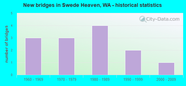
- New bridges - historical statistics
- 31960-1969
- 31970-1979
- 41980-1989
- 21990-1999
- 12000-2009


- Bridge Condition - Deck
- 7.7%Very good
- 61.5%Good
- 30.8%Satisfactory

- Bridge Condition - Superstructure
- 69.2%Good
- 15.4%Satisfactory
- 15.4%Fair

- Bridge Condition - Substructure
- 7.7%Very good
- 76.9%Good
- 15.4%Satisfactory

- Bridge Condition - Channel
- 38.5%Very good
- 30.8%Good
- 30.8%Satisfactory
Find on map >> Show street view
Structure Number: 6897A, Location: 19.0 E JCT SR 9 (Lat: 48.277839, Lng: -121.781311), Route carried "on" structure: State highway 530, Year Built: 1962, Year Reconstructed: 1996, Status: Open, Structure Length: 5.03m (16.50ft), Average Daily Traffic: 3,517 (year 2019), Truck Traffic: 14%, Average Future Daily Traffic: 5,092 (year 2039), Design Load: HS 20, Features Intersected: BOULDER CREEK
Minimum Vertical Clearance: 30+ m (98+ ft), Kilometerpoint: 64.583, Lanes on structure: 2, Base Highway Network: Yes, Owner: State Highway Agency, Approaching Roadway Width: 9.8m (32.2ft), Skew: 3 degrees, Material/Design: Prestressed concrete, Design/Construction: Stringer/Multi-beam, Number Of Spans In Main Unit: 2, Length of Maximum Span: 23.8m (78.1ft), Curb-To-Curb Width: 9.8m (32.2ft), Out-to-Out Width: 10.7m (35.1ft)
Condition: Deck: Very good, Superstructure: Good, Substructure: Good, Channel: Satisfactory, Operating Rating: 68.0 metric tons, Method Used To Determine Operating Rating: Load Factor (LF), Inventory Rating: 40.8 metric tons, Method Used To Determine Inventory Rating: Load Factor (LF), Structural Evaluation: Better than present minimum criteria, Deck Geometry: Meets minimum limits, Waterway Adequacy: Equal to present desirable criteria, Approach Roadway Alignment: Equal to present desirable criteria, Length Of Structure Improvement: 5.03m (16.50ft), Designated Inspection Frequency: Every 24 months, Inspection Date: April 2021, Bridge Improvement Cost: $1,122,000, Roadway Improvement Cost: $224,000, Total Project Cost: $2,244,000 ( Estimate for 2014), Deck Structure Type: Concrete Cast-file-Place, Wearing Surface/Protective System: Wearing Surface: Bituminous, Membrane: Preformed Fabric
Find on map >> Show street view
Structure Number: 8804A, Location: 23.9 E JCT SR 9 (Lat: 48.269194, Lng: -121.677917), Route carried "on" structure: State highway 530, Year Built: 1970, Status: Open, Structure Length: 2.62m (8.60ft), Average Daily Traffic: 3,308 (year 2019), Truck Traffic: 14%, Average Future Daily Traffic: 4,789 (year 2039), Design Load: HS 20+Mod, Features Intersected: FIRLAND CREEK
Minimum Vertical Clearance: 30+ m (98+ ft), Kilometerpoint: 72.517, Lanes on structure: 2, Base Highway Network: Yes, Owner: State Highway Agency, Approaching Roadway Width: 12.2m (40.0ft), Skew: 1 degrees, Material/Design: Concrete continuous, Design/Construction: Slab, Number Of Spans In Main Unit: 3, Length of Maximum Span: 10.1m (33.1ft), Curb or Sidewalk Widths: Left: 0.2m (0.7ft), Right: 0.2m (0.7ft), Curb-To-Curb Width: 11.0m (36.1ft), Out-to-Out Width: 12.0m (39.4ft)
Condition: Deck: Good, Superstructure: Good, Substructure: Good, Channel: Very good, Operating Rating: 66.2 metric tons, Method Used To Determine Operating Rating: Load Factor (LF), Inventory Rating: 39.9 metric tons, Method Used To Determine Inventory Rating: Load Factor (LF), Structural Evaluation: Better than present minimum criteria, Deck Geometry: Somewhat better than minimum adequacy, Waterway Adequacy: Equal to present desirable criteria, Approach Roadway Alignment: Equal to present desirable criteria, Length Of Structure Improvement: 2.62m (8.60ft), Designated Inspection Frequency: Every 48 months, Inspection Date: August 2018, Bridge Improvement Cost: $722,000, Roadway Improvement Cost: $144,000, Total Project Cost: $1,445,000 ( Estimate for 2014), Deck Structure Type: Concrete Cast-file-Place, Wearing Surface/Protective System: Wearing Surface: Bituminous
Find on map >> Show street view
Structure Number: 8804B, Location: 24.0 E JCT SR 9 (Lat: 48.269222, Lng: -121.675611), Route carried "on" structure: State highway 530, Year Built: 1970, Status: Open, Structure Length: 2.87m (9.42ft), Average Daily Traffic: 3,308 (year 2019), Truck Traffic: 14%, Average Future Daily Traffic: 4,789 (year 2039), Design Load: HS 20+Mod, Features Intersected: ASHTON CREEK
Minimum Vertical Clearance: 30+ m (98+ ft), Kilometerpoint: 72.678, Lanes on structure: 2, Base Highway Network: Yes, Owner: State Highway Agency, Approaching Roadway Width: 12.2m (40.0ft), Skew: 1 degrees, Material/Design: Concrete continuous, Design/Construction: Slab, Number Of Spans In Main Unit: 3, Length of Maximum Span: 11.0m (36.1ft), Curb or Sidewalk Widths: Left: 0.2m (0.7ft), Right: 0.2m (0.7ft), Curb-To-Curb Width: 11.0m (36.1ft), Out-to-Out Width: 12.0m (39.4ft)
Condition: Deck: Good, Superstructure: Good, Substructure: Good, Channel: Very good, Operating Rating: 62.6 metric tons, Method Used To Determine Operating Rating: Load Factor (LF), Inventory Rating: 38.1 metric tons, Method Used To Determine Inventory Rating: Load Factor (LF), Structural Evaluation: Better than present minimum criteria, Deck Geometry: Somewhat better than minimum adequacy, Waterway Adequacy: Equal to present desirable criteria, Approach Roadway Alignment: Equal to present desirable criteria, Length Of Structure Improvement: 2.87m (9.42ft), Designated Inspection Frequency: Every 48 months, Inspection Date: August 2018, Bridge Improvement Cost: $790,000, Roadway Improvement Cost: $158,000, Total Project Cost: $1,579,000 ( Estimate for 2014), Deck Structure Type: Concrete Cast-file-Place, Wearing Surface/Protective System: Wearing Surface: Bituminous
Find on map >> Show street view
Structure Number: 9423A, Location: 24.3 E JCT SR 9 (Lat: 48.270000, Lng: -121.671417), Route carried "on" structure: State highway 530, Year Built: 1972, Status: Open, Structure Length: 3.44m (11.29ft), Average Daily Traffic: 3,285 (year 2019), Truck Traffic: 14%, Average Future Daily Traffic: 4,756 (year 2039), Design Load: HS 20+Mod, Features Intersected: SQUIRE CREEK
Minimum Vertical Clearance: 30+ m (98+ ft), Kilometerpoint: 73.016, Lanes on structure: 2, Base Highway Network: Yes, Owner: State Highway Agency, Approaching Roadway Width: 12.2m (40.0ft), Material/Design: Prestressed concrete, Design/Construction: Stringer/Multi-beam, Number Of Spans In Main Unit: 1, Length of Maximum Span: 32.9m (107.9ft), Curb-To-Curb Width: 11.0m (36.1ft), Out-to-Out Width: 11.5m (37.7ft)
Condition: Deck: Satisfactory, Superstructure: Good, Substructure: Very good, Channel: Very good, Operating Rating: 41.8 metric tons, Method Used To Determine Operating Rating: Load and Resistance Factor Rating (LRFR) rating reported by rating factor(RF) method using HL-93 loadings, Inventory Rating: 24.9 metric tons, Method Used To Determine Inventory Rating: Load and Resistance Factor Rating (LRFR) rating reported by rating factor(RF) method using HL-93 loadings, Structural Evaluation: Equal to present minimum criteria, Deck Geometry: Somewhat better than minimum adequacy, Waterway Adequacy: Equal to present desirable criteria, Approach Roadway Alignment: Equal to present desirable criteria, Length Of Structure Improvement: 3.44m (11.29ft), Designated Inspection Frequency: Every 48 months, Inspection Date: August 2018, Bridge Improvement Cost: $949,000, Roadway Improvement Cost: $190,000, Total Project Cost: $1,898,000 ( Estimate for 2014), Deck Structure Type: Concrete Cast-file-Place, Wearing Surface/Protective System: Wearing Surface: Integral Concrete
Find on map >> Show street view
Structure Number: 12113A, Location: 20.2 E JCT SR 9 (Lat: 48.277694, Lng: -121.755028), Route carried "on" structure: State highway 530, Year Built: 1982, Status: Open, Structure Length: 3.96m (12.99ft), Average Daily Traffic: 3,517 (year 2019), Truck Traffic: 14%, Average Future Daily Traffic: 5,092 (year 2039), Design Load: HS 20, Features Intersected: FRENCH CREEK
Minimum Vertical Clearance: 30+ m (98+ ft), Kilometerpoint: 66.562, Lanes on structure: 2, Base Highway Network: Yes, Owner: State Highway Agency, Approaching Roadway Width: 12.2m (40.0ft), Skew: 3 degrees, Material/Design: Prestressed concrete, Design/Construction: Stringer/Multi-beam, Number Of Spans In Main Unit: 1, Length of Maximum Span: 39.6m (129.9ft), Curb-To-Curb Width: 11.0m (36.1ft), Out-to-Out Width: 11.9m (39.0ft)
Condition: Deck: Good, Superstructure: Good, Substructure: Good, Channel: Very good, Operating Rating: 25.3 metric tons, Method Used To Determine Operating Rating: Load and Resistance Factor Rating (LRFR) rating reported by rating factor(RF) method using HL-93 loadings, Inventory Rating: 19.4 metric tons, Method Used To Determine Inventory Rating: Load and Resistance Factor Rating (LRFR) rating reported by rating factor(RF) method using HL-93 loadings, Structural Evaluation: Somewhat better than minimum adequacy, Deck Geometry: Somewhat better than minimum adequacy, Waterway Adequacy: Equal to present desirable criteria, Approach Roadway Alignment: Equal to present desirable criteria, Length Of Structure Improvement: 3.96m (12.99ft), Designated Inspection Frequency: Every 48 months, Inspection Date: August 2018, Bridge Improvement Cost: $1,092,000, Roadway Improvement Cost: $218,000, Total Project Cost: $2,184,000 ( Estimate for 2014), Deck Structure Type: Concrete Cast-file-Place, Wearing Surface/Protective System: Wearing Surface: Bituminous, Membrane: Preformed Fabric
Find on map >> Show street view
Structure Number: 60502000001435, Location: M.P. 0.1 RD. NO. 2820 (Lat: 48.336811, Lng: -121.637461), Route carried "on" structure: Federal lands road 28000, Year Built: 1966, Status: Open, Structure Length: 2.65m (8.69ft), Average Daily Traffic: 62 (year 1992), Average Future Daily Traffic: 93 (year 2042), Features Intersected: CREVICE CREEK, Facility Carried by Structure: RD. NO. 2820
Minimum Vertical Clearance: 30+ m (98+ ft), Kilometerpoint: 0.160, Lanes on structure: 1, Owner: U.S. Forest Service, Approaching Roadway Width: 4.3m (14.1ft), Material/Design: Concrete continuous, Design/Construction: Frame, Number Of Spans In Main Unit: 2, Length of Maximum Span: 21.3m (69.9ft), Curb or Sidewalk Widths: Left: 1.1m (3.6ft), Right: 0.3m (1.0ft), Curb-To-Curb Width: 4.3m (14.1ft), Out-to-Out Width: 5.6m (18.4ft)
Condition: Deck: Satisfactory, Superstructure: Fair, Substructure: Good, Channel: Satisfactory, Operating Rating: 37.2 metric tons, Method Used To Determine Operating Rating: Load Factor (LF), Inventory Rating: 25.4 metric tons, Method Used To Determine Inventory Rating: Load Factor (LF), Structural Evaluation: Somewhat better than minimum adequacy, Deck Geometry: Equal to present minimum criteria, Waterway Adequacy: Equal to present desirable criteria, Approach Roadway Alignment: Better than present minimum criteria, Designated Inspection Frequency: Every 24 months, Inspection Date: October 2021, Deck Structure Type: Concrete Cast-file-Place
Find on map >> Show street view
Structure Number: 60502000001441, Location: M.P. 0.2 RD. NO. 2820 (Lat: 48.335856, Lng: -121.637300), Route carried "on" structure: Federal lands road 28200, Year Built: 1967, Status: Open, Structure Length: 3.41m (11.19ft), Average Daily Traffic: 62 (year 1992), Average Future Daily Traffic: 93 (year 2042), Features Intersected: N FORK STILLY RIVER, Facility Carried by Structure: RD. NO. 2820
Minimum Vertical Clearance: 30+ m (98+ ft), Kilometerpoint: 0.320, Lanes on structure: 1, Owner: U.S. Forest Service, Approaching Roadway Width: 4.3m (14.1ft), Skew: 1 degrees, Material/Design: Concrete continuous, Design/Construction: Box Beam or Girders - Single/Spread, Number Of Spans In Main Unit: 2, Length of Maximum Span: 27.6m (90.6ft), Curb or Sidewalk Widths: Left: 0.3m (1.0ft), Right: 1.1m (3.6ft), Curb-To-Curb Width: 4.3m (14.1ft), Out-to-Out Width: 5.6m (18.4ft)
Condition: Deck: Good, Superstructure: Fair, Substructure: Good, Channel: Very good, Operating Rating: 40.0 metric tons, Method Used To Determine Operating Rating: Load Factor (LF), Inventory Rating: 24.5 metric tons, Method Used To Determine Inventory Rating: Load Factor (LF), Structural Evaluation: Somewhat better than minimum adequacy, Deck Geometry: Equal to present minimum criteria, Waterway Adequacy: Equal to present desirable criteria, Approach Roadway Alignment: Meets minimum limits, Designated Inspection Frequency: Every 24 months, Inspection Date: October 2021, Deck Structure Type: Concrete Cast-file-Place
Find on map >> Show street view
Structure Number: 60502000001472, Location: NO DATA ENTERED (Lat: 48.301236, Lng: -121.718892), Route carried "on" structure: Federal lands road 18900, Year Built: 1982, Status: Open, Structure Length: 1.85m (6.07ft), Average Daily Traffic: 22 (year 1985), Average Future Daily Traffic: 33 (year 2042), Features Intersected: SWEDE CREEK, Facility Carried by Structure: ROAD
Minimum Vertical Clearance: 30+ m (98+ ft), Kilometerpoint: 2.880, Lanes on structure: 1, Owner: U.S. Forest Service, Approaching Roadway Width: 3.7m (12.1ft), Material/Design: Steel, Design/Construction: Stringer/Multi-beam, Number Of Spans In Main Unit: 1, Length of Maximum Span: 18.1m (59.4ft), Curb or Sidewalk Widths: Left: 0.3m (1.0ft), Right: 0.3m (1.0ft), Curb-To-Curb Width: 4.9m (16.1ft), Out-to-Out Width: 5.5m (18.0ft)
Condition: Deck: Satisfactory, Superstructure: Good, Substructure: Satisfactory, Channel: Good, Operating Rating: 29.1 metric tons, Method Used To Determine Operating Rating: Allowable Stress (AS), Inventory Rating: 20.9 metric tons, Method Used To Determine Inventory Rating: Allowable Stress (AS), Structural Evaluation: Equal to present minimum criteria, Deck Geometry: High priority of corrective action, Waterway Adequacy: Superior to present desirable criteria, Approach Roadway Alignment: Equal to present minimum criteria, Designated Inspection Frequency: Every 24 months, Inspection Date: October 2021, Deck Structure Type: Wood or Timber, Wearing Surface/Protective System: Wearing Surface: Wood or Timber
Find on map >> Show street view
Structure Number: 79704, Location: 1.7 NW JCT SR 530 (Lat: 48.283561, Lng: -121.715711), Route carried "on" structure: County highway 84150, Year Built: 1981, Status: Open, Structure Length: 1.68m (5.51ft), Average Daily Traffic: 599 (year 2018), Truck Traffic: 12%, Average Future Daily Traffic: 1,000 (year 2040), Design Load: HS 20, Features Intersected: SEGELSON CREEK, Facility Carried by Structure: SWEDE HEAVEN RD
Minimum Vertical Clearance: 30+ m (98+ ft), Kilometerpoint: 0.001, Lanes on structure: 2, Owner: County Highway Agency, Approaching Roadway Width: 8.5m (27.9ft), Material/Design: Prestressed concrete, Design/Construction: Tee Beam, Number Of Spans In Main Unit: 1, Length of Maximum Span: 15.8m (51.8ft), Curb-To-Curb Width: 8.5m (27.9ft), Out-to-Out Width: 9.5m (31.2ft)
Condition: Deck: Good, Superstructure: Good, Substructure: Good, Channel: Good, Operating Rating: 43.5 metric tons, Method Used To Determine Operating Rating: Load Factor (LF), Inventory Rating: 25.4 metric tons, Method Used To Determine Inventory Rating: Load Factor (LF), Structural Evaluation: Equal to present minimum criteria, Deck Geometry: Somewhat better than minimum adequacy, Waterway Adequacy: Better than present minimum criteria, Approach Roadway Alignment: Equal to present desirable criteria, Length Of Structure Improvement: 1.98m (6.50ft), Designated Inspection Frequency: Every 24 months, Inspection Date: June 2020, Bridge Improvement Cost: $988,000, Roadway Improvement Cost: $198,000, Total Project Cost: $1,976,000 ( Estimate for 2014), Deck Structure Type: Other, Wearing Surface/Protective System: Wearing Surface: Bituminous
Find on map >> Show street view
Structure Number: 79713, Location: 2.1 NW JCT SR 530 (Lat: 48.284158, Lng: -121.724897), Route carried "on" structure: County highway 84150, Year Built: 1985, Status: Open, Structure Length: 0.94m (3.08ft), Average Daily Traffic: 435 (year 2017), Truck Traffic: 13%, Average Future Daily Traffic: 800 (year 2040), Design Load: HS 15, Features Intersected: TRIB.N.F.STILLAGUAMISH R, Facility Carried by Structure: SWEDE HEAVEN RD
Minimum Vertical Clearance: 30+ m (98+ ft), Kilometerpoint: 0.001, Lanes on structure: 2, Owner: County Highway Agency, Approaching Roadway Width: 7.0m (23.0ft), Skew: 3 degrees, Material/Design: Wood or Timber, Design/Construction: Stringer/Multi-beam, Number Of Spans In Main Unit: 1, Length of Maximum Span: 7.9m (25.9ft), Curb-To-Curb Width: 7.4m (24.3ft), Out-to-Out Width: 7.7m (25.3ft)
Condition: Deck: Satisfactory, Superstructure: Satisfactory, Substructure: Good, Channel: Satisfactory, Operating Rating: 38.1 metric tons, Method Used To Determine Operating Rating: Allowable Stress (AS), Inventory Rating: 27.2 metric tons, Method Used To Determine Inventory Rating: Allowable Stress (AS), Structural Evaluation: Equal to present minimum criteria, Deck Geometry: Meets minimum limits, Waterway Adequacy: Equal to present minimum criteria, Approach Roadway Alignment: Equal to present minimum criteria, Length Of Structure Improvement: 1.25m (4.10ft), Designated Inspection Frequency: Every 24 months, Inspection Date: June 2020, Bridge Improvement Cost: $623,000, Roadway Improvement Cost: $125,000, Total Project Cost: $1,246,000 ( Estimate for 2014), Deck Structure Type: Wood or Timber, Wearing Surface/Protective System: Wearing Surface: Wood or Timber
Find on map >> Show street view
Structure Number: 80614, Location: 1.2 NW JCT SR 530 (Lat: 48.283467, Lng: -121.705542), Route carried "on" structure: Spur County highway 84150, Year Built: 2002, Status: Open, Structure Length: 0.76m (2.49ft), Average Daily Traffic: 657 (year 2017), Truck Traffic: 10%, Average Future Daily Traffic: 1,000 (year 2041), Design Load: HS 20, Features Intersected: BLACK CREEK, Facility Carried by Structure: SWEDE HEAVEN RD
Minimum Vertical Clearance: 30+ m (98+ ft), Kilometerpoint: 0.001, Lanes on structure: 2, Owner: County Highway Agency, Approaching Roadway Width: 6.4m (21.0ft), Material/Design: Wood or Timber, Design/Construction: Stringer/Multi-beam, Number Of Spans In Main Unit: 1, Length of Maximum Span: 6.7m (22.0ft), Curb-To-Curb Width: 6.5m (21.3ft), Out-to-Out Width: 6.8m (22.3ft)
Condition: Deck: Good, Superstructure: Good, Substructure: Good, Channel: Good, Operating Rating: 39.9 metric tons, Method Used To Determine Operating Rating: Allowable Stress (AS), Inventory Rating: 29.0 metric tons, Method Used To Determine Inventory Rating: Allowable Stress (AS), Structural Evaluation: Better than present minimum criteria, Deck Geometry: High priority of corrective action, Waterway Adequacy: Equal to present desirable criteria, Approach Roadway Alignment: Equal to present desirable criteria, Length Of Structure Improvement: 1.07m (3.51ft), Designated Inspection Frequency: Every 24 months, Inspection Date: May 2021, Bridge Improvement Cost: $532,000, Roadway Improvement Cost: $106,000, Total Project Cost: $1,064,000 ( Estimate for 2014), Deck Structure Type: Wood or Timber, Wearing Surface/Protective System: Wearing Surface: Bituminous
Find on map >> Show street view
Structure Number: 8596, Location: 0.8 N JCT SR 530 (Lat: 48.279944, Lng: -121.702889), Route carried "on" structure: County highway 84150, Year Built: 1991, Status: Open, Structure Length: 9.39m (30.81ft), Average Daily Traffic: 863 (year 2018), Truck Traffic: 14%, Average Future Daily Traffic: 1,200 (year 2040), Design Load: HS 20, Features Intersected: N.F.STILLAGUAMISH RIVER, Facility Carried by Structure: SWEDE HEAVEN RD
Minimum Vertical Clearance: 30+ m (98+ ft), Kilometerpoint: 0.001, Lanes on structure: 2, Owner: County Highway Agency, Approaching Roadway Width: 10.4m (34.1ft), Skew: 1 degrees, Material/Design: Prestressed concrete continuous, Design/Construction: Stringer/Multi-beam, Number Of Spans In Main Unit: 3, Length of Maximum Span: 39.0m (128.0ft), Curb-To-Curb Width: 10.4m (34.1ft), Out-to-Out Width: 11.2m (36.7ft)
Condition: Deck: Good, Superstructure: Good, Substructure: Good, Channel: Satisfactory, Inventory Rating: 73.5 metric tons, Method Used To Determine Inventory Rating: Load Factor (LF), Structural Evaluation: Better than present minimum criteria, Deck Geometry: Equal to present minimum criteria, Waterway Adequacy: Equal to present desirable criteria, Approach Roadway Alignment: Equal to present minimum criteria, Length Of Structure Improvement: 9.69m (31.79ft), Designated Inspection Frequency: Every 24 months, Inspection Date: May 2020, Bridge Improvement Cost: $4,834,000, Roadway Improvement Cost: $967,000, Total Project Cost: $9,667,000 ( Estimate for 2014), Deck Structure Type: Concrete Cast-file-Place, Wearing Surface/Protective System: Wearing Surface: Monolithic Concrete, Deck Protection: Epoxy Coated Reinforcing
Find on map >> Show street view
Structure Number: 86026, Location: 2.8 NW JCT SR 530 (Lat: 48.280489, Lng: -121.735658), Route carried "on" structure: County highway 84260, Year Built: 1992, Status: Posted for load, Structure Length: 0.76m (2.49ft), Average Daily Traffic: 139 (year 2017), Truck Traffic: 17%, Average Future Daily Traffic: 400 (year 2040), Design Load: HS 15, Features Intersected: TRIB.N.F.STILLAGUAMISH, Facility Carried by Structure: 365 TH DR NE
Minimum Vertical Clearance: 30+ m (98+ ft), Kilometerpoint: 0.001, Lanes on structure: 2, Owner: County Highway Agency, Approaching Roadway Width: 7.0m (23.0ft), Material/Design: Wood or Timber, Design/Construction: Stringer/Multi-beam, Number Of Spans In Main Unit: 1, Length of Maximum Span: 6.7m (22.0ft), Curb-To-Curb Width: 7.4m (24.3ft), Out-to-Out Width: 7.7m (25.3ft)
Condition: Deck: Good, Superstructure: Satisfactory, Substructure: Satisfactory, Channel: Good, Operating Rating: 48.1 metric tons, Method Used To Determine Operating Rating: Allowable Stress (AS), Inventory Rating: 33.6 metric tons, Method Used To Determine Inventory Rating: Allowable Stress (AS), Structural Evaluation: Equal to present minimum criteria, Deck Geometry: Somewhat better than minimum adequacy, Waterway Adequacy: Equal to present minimum criteria, Approach Roadway Alignment: Equal to present desirable criteria, Length Of Structure Improvement: 1.07m (3.51ft), Designated Inspection Frequency: Every 24 months, Inspection Date: July 2020, Bridge Improvement Cost: $532,000, Roadway Improvement Cost: $106,000, Total Project Cost: $1,064,000 ( Estimate for 2014), Deck Structure Type: Wood or Timber, Wearing Surface/Protective System: Wearing Surface: Bituminous, Membrane: Preformed Fabric