Bridge Statistics for Sweet Springs, Missouri (MO)
Condition, Traffic, Stress, Structural Evaluation, Project Costs
- National Bridge Inventory (NBI) Statistics
- 24Number of bridges
- 302ft / 91.5mTotal length
- $1,577,000Total costs
- 76,520Total average daily traffic
- 30,506Total average daily truck traffic
- National Bridge Inventory (NBI) Registered Bridges for Sweet Springs
- No street view available for this location
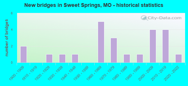
- New bridges - historical statistics
- 21900-1909
- 11920-1929
- 11930-1939
- 11940-1949
- 51960-1969
- 31970-1979
- 11980-1989
- 11990-1999
- 42000-2009
- 42010-2019
- 12020-2022

- Reconstructed bridges - Historical Statistics
- 11970-1979
- 31980-1989
- 11990-1999
- 12000-2009


- Bridge Condition - Deck
- 11.1%Excellent
- 22.2%Very good
- 50.0%Good
- 11.1%Satisfactory
- 5.6%Fair

- Bridge Condition - Superstructure
- 11.1%Excellent
- 16.7%Very good
- 38.9%Good
- 22.2%Satisfactory
- 11.1%Fair

- Bridge Condition - Substructure
- 16.7%Excellent
- 22.2%Very good
- 22.2%Good
- 27.8%Satisfactory
- 11.1%Fair

- Bridge Condition - Channel
- 13.6%Very good
- 4.5%Good
- 40.9%Satisfactory
- 40.9%Fair

- Bridge Condition - Culverts
- 75.0%Good
- 25.0%Satisfactory
Find on map >> Show street view
Structure Number: 13899, Location: S 26 T 48 N R 23 W (Lat: 38.915581, Lng: -93.420981), Route carried "on" structure: County highway 51, Year Built: 1964, Year Reconstructed: 1989, Status: Open, Structure Length: 2.47m (8.10ft), Average Daily Traffic: 50 (year 2020), Truck Traffic: 10%, Average Future Daily Traffic: 85 (year 2040), Features Intersected: S FORK, Facility Carried by Structure: SOUTHFORK RD
Minimum Vertical Clearance: 30+ m (98+ ft), Kilometerpoint: 1.127, Lanes on structure: 2, Owner: County Highway Agency, Approaching Roadway Width: 7.3m (24.0ft), Material/Design: Steel, Design/Construction: Girder and Floorbeam System, Number Of Spans In Main Unit: 1, Length of Maximum Span: 22.9m (75.1ft), Curb-To-Curb Width: 6.1m (20.0ft), Out-to-Out Width: 6.1m (20.0ft)
Condition: Deck: Good, Superstructure: Satisfactory, Substructure: Fair, Channel: Fair, Operating Rating: 45.0 metric tons, Method Used To Determine Operating Rating: Allowable Stress (AS), Inventory Rating: 27.0 metric tons, Method Used To Determine Inventory Rating: Allowable Stress (AS), Structural Evaluation: Somewhat better than minimum adequacy, Deck Geometry: Somewhat better than minimum adequacy, Waterway Adequacy: Equal to present minimum criteria, Approach Roadway Alignment: Equal to present minimum criteria, Designated Inspection Frequency: Every 24 months, Critical Feature Inspection Frequency: Every 24 months, Inspection Date: Febuary 2022, Critical Feature Inspection Date: Febuary 2022, Deck Structure Type: Corrugated Steel, Wearing Surface/Protective System: Wearing Surface: Bituminous
Find on map >> Show street view
Structure Number: 13914, Location: S 26 T 48 N R 23 W (Lat: 38.914011, Lng: -93.404761), Route carried "on" structure: County highway 51, Year Built: 1989, Status: Open, Structure Length: 0.88m (2.89ft), Average Daily Traffic: 50 (year 2020), Truck Traffic: 10%, Average Future Daily Traffic: 85 (year 2040), Features Intersected: BUNCOMB BR, Facility Carried by Structure: SOUTHFORK RD
Minimum Vertical Clearance: 30+ m (98+ ft), Kilometerpoint: 2.736, Lanes on structure: 2, Owner: County Highway Agency, Approaching Roadway Width: 7.3m (24.0ft), Material/Design: Concrete, Design/Construction: Culvert, Number Of Spans In Main Unit: 2, Length of Maximum Span: 4.3m (14.1ft), Curb-To-Curb Width: 11.2m (36.7ft), Out-to-Out Width: 11.2m (36.7ft)
Condition: Channel: Fair, Culverts: Good, Operating Rating: 49.5 metric tons, Method Used To Determine Operating Rating: Allowable Stress (AS), Inventory Rating: 32.4 metric tons, Method Used To Determine Inventory Rating: Allowable Stress (AS), Structural Evaluation: Better than present minimum criteria, Deck Geometry: Superior to present desirable criteria, Waterway Adequacy: Better than present minimum criteria, Approach Roadway Alignment: Equal to present desirable criteria, Designated Inspection Frequency: Every 24 months, Inspection Date: Febuary 2022
Find on map >> Show street view
Structure Number: 14043, Location: S 3 T 47 N R 23 W (Lat: 38.888581, Lng: -93.425031), Route carried "on" structure: County highway 55, Year Built: 1908, Year Reconstructed: 1986, Status: Open, Structure Length: 4.18m (13.71ft), Average Daily Traffic: 40 (year 2020), Truck Traffic: 10%, Average Future Daily Traffic: 68 (year 2040), Features Intersected: TRIB TO BEAR BR, Facility Carried by Structure: HIGGINS RD
Minimum Vertical Clearance: 30+ m (98+ ft), Kilometerpoint: 1.287, Lanes on structure: 2, Owner: County Highway Agency, Approaching Roadway Width: 7.9m (25.9ft), Material/Design: Prestressed concrete, Design/Construction: Tee Beam, Number Of Spans In Main Unit: 3, Length of Maximum Span: 13.7m (44.9ft), Curb-To-Curb Width: 7.3m (24.0ft), Out-to-Out Width: 7.9m (25.9ft)
Condition: Deck: Good, Superstructure: Good, Substructure: Very good, Channel: Satisfactory, Operating Rating: 66.6 metric tons, Method Used To Determine Operating Rating: Allowable Stress (AS), Inventory Rating: 48.6 metric tons, Method Used To Determine Inventory Rating: Allowable Stress (AS), Structural Evaluation: Better than present minimum criteria, Deck Geometry: Equal to present minimum criteria, Waterway Adequacy: Equal to present desirable criteria, Approach Roadway Alignment: Equal to present minimum criteria, Designated Inspection Frequency: Every 24 months, Inspection Date: Febuary 2022, Deck Structure Type: Concrete Cast-file-Place, Wearing Surface/Protective System: Wearing Surface: Monolithic Concrete
Find on map >> Show street view
Structure Number: 162, Location: S 5 T 48 N R 22 W (Lat: 38.974439, Lng: -93.362600), Route carried "on" structure: Interstate 70, Year Built: 1961, Status: Open, Structure Length: 1.06m (3.48ft), Average Daily Traffic: 29,382 (year 2021), Truck Traffic: 43%, Average Future Daily Traffic: 51,419 (year 2041), Design Load: HS 20, Features Intersected: COOPERAS CR
Minimum Vertical Clearance: 30+ m (98+ ft), Kilometerpoint: 112.197, Lanes on structure: 4, Base Highway Network: Yes, Owner: State Highway Agency, Approaching Roadway Width: 32.9m (107.9ft), Skew: 20 degrees, Material/Design: Concrete continuous, Design/Construction: Culvert, Number Of Spans In Main Unit: 3, Length of Maximum Span: 3.4m (11.2ft)
Condition: Channel: Fair, Culverts: Satisfactory, Operating Rating: 72.0 metric tons, Method Used To Determine Operating Rating: Field evaluation and documented engineering judgment, Inventory Rating: 43.2 metric tons, Method Used To Determine Inventory Rating: Field evaluation and documented engineering judgment, Structural Evaluation: Equal to present minimum criteria, Waterway Adequacy: Equal to present desirable criteria, Approach Roadway Alignment: Equal to present desirable criteria, Designated Inspection Frequency: Every 24 months, Inspection Date: December 2021
Find on map >> Show street view
Structure Number: 23805, Location: S 13 T 49 N R 23 W (Lat: 39.031044, Lng: -93.397417), Route carried "on" structure: County highway 434, Year Built: 1905, Year Reconstructed: 1985, Status: Posted for load, Structure Length: 1.52m (4.99ft), Average Daily Traffic: 35 (year 2021), Truck Traffic: 10%, Average Future Daily Traffic: 39 (year 2041), Features Intersected: SALT POND CR, Facility Carried by Structure: 163RD TRL
Minimum Vertical Clearance: 30+ m (98+ ft), Kilometerpoint: 0.483, Lanes on structure: 2, Owner: County Highway Agency, Approaching Roadway Width: 5.8m (19.0ft), Material/Design: Steel, Design/Construction: Stringer/Multi-beam, Number Of Spans In Main Unit: 1, Length of Maximum Span: 14.6m (47.9ft), Curb-To-Curb Width: 6.1m (20.0ft), Out-to-Out Width: 6.1m (20.0ft)
Condition: Deck: Good, Superstructure: Good, Substructure: Satisfactory, Channel: Satisfactory, Operating Rating: 29.7 metric tons, Method Used To Determine Operating Rating: Allowable Stress (AS), Inventory Rating: 18.0 metric tons, Method Used To Determine Inventory Rating: Allowable Stress (AS), Structural Evaluation: Somewhat better than minimum adequacy, Deck Geometry: Somewhat better than minimum adequacy, Waterway Adequacy: Somewhat better than minimum adequacy, Approach Roadway Alignment: Equal to present minimum criteria, Designated Inspection Frequency: Every 24 months, Inspection Date: March 2020, Deck Structure Type: Concrete Cast-file-Place, Wearing Surface/Protective System: Wearing Surface: Monolithic Concrete
Find on map >> Show street view
Structure Number: 2384, Location: S 25 T 49 N R 23 W (Lat: 39.012489, Lng: -93.396378), Route carried "on" structure: County highway 436, Year Built: 1978, Status: Open, Structure Length: 1.52m (4.99ft), Average Daily Traffic: 35 (year 2021), Truck Traffic: 10%, Average Future Daily Traffic: 39 (year 2041), Features Intersected: SALT POND CR, Facility Carried by Structure: 150TH RD
Minimum Vertical Clearance: 30+ m (98+ ft), Kilometerpoint: 1.609, Lanes on structure: 1, Owner: County Highway Agency, Approaching Roadway Width: 6.7m (22.0ft), Material/Design: Steel, Design/Construction: Stringer/Multi-beam, Number Of Spans In Main Unit: 1, Length of Maximum Span: 14.9m (48.9ft), Curb-To-Curb Width: 4.9m (16.1ft), Out-to-Out Width: 4.9m (16.1ft)
Condition: Deck: Satisfactory, Superstructure: Good, Substructure: Fair, Channel: Satisfactory, Operating Rating: 41.4 metric tons, Method Used To Determine Operating Rating: Allowable Stress (AS), Inventory Rating: 26.1 metric tons, Method Used To Determine Inventory Rating: Allowable Stress (AS), Structural Evaluation: Somewhat better than minimum adequacy, Deck Geometry: High priority of corrective action, Waterway Adequacy: Better than present minimum criteria, Approach Roadway Alignment: Equal to present minimum criteria, Length Of Structure Improvement: 0.22m (0.72ft), Designated Inspection Frequency: Every 24 months, Inspection Date: March 2020, Bridge Improvement Cost: $109,000, Roadway Improvement Cost: $11,000, Total Project Cost: $163,000 ( Estimate for 2022), Deck Structure Type: Concrete Cast-file-Place, Wearing Surface/Protective System: Wearing Surface: Monolithic Concrete
Find on map >> Show street view
Structure Number: 23875, Location: S 13 T 48 N R 23 W (Lat: 38.941547, Lng: -93.396169), Route carried "on" structure: County highway 439, Year Built: 1930, Status: Posted for load, Structure Length: 7.35m (24.11ft), Average Daily Traffic: 35 (year 2021), Truck Traffic: 10%, Average Future Daily Traffic: 39 (year 2041), Features Intersected: BLACKWATER RVR, Facility Carried by Structure: CONCORD AVE
Minimum Vertical Clearance: 5.49m (18.01ft), Kilometerpoint: 2.414, Lanes on structure: 1, Owner: County Highway Agency, Approaching Roadway Width: 7.0m (23.0ft), Material/Design: Steel, Design/Construction: Truss - Thru, Number Of Spans In Main Unit: 1, Number Of Approach Spans: 2, Length of Maximum Span: 42.7m (140.1ft), Curb-To-Curb Width: 4.0m (13.1ft), Out-to-Out Width: 4.3m (14.1ft)
Condition: Deck: Good, Superstructure: Fair, Substructure: Good, Channel: Fair, Operating Rating: 9.0 metric tons, Method Used To Determine Operating Rating: Allowable Stress (AS), Inventory Rating: 5.4 metric tons, Method Used To Determine Inventory Rating: Allowable Stress (AS), Structural Evaluation: High priority of replacement, Deck Geometry: Somewhat better than minimum adequacy, Waterway Adequacy: Meets minimum limits, Approach Roadway Alignment: Equal to present minimum criteria, Bridge Posting: Required (Relationship of Operating Rating to Maximum Legal Load: > 39.9% below), Length Of Structure Improvement: 0.84m (2.76ft), Designated Inspection Frequency: Every 24 months, Critical Feature Inspection Frequency: Every 24 months, Inspection Date: March 2020, Critical Feature Inspection Date: March 2020, Bridge Improvement Cost: $783,000, Roadway Improvement Cost: $78,000, Total Project Cost: $1,174,000 ( Estimate for 2022), Deck Structure Type: Wood or Timber, Wearing Surface/Protective System: Wearing Surface: Wood or Timber
Find on map >> Show street view
Structure Number: 23904, Location: S 27 T 49 N R 23 W (Lat: 39.002806, Lng: -93.431231), Route carried "on" structure: County highway 442, Year Built: 1920, Year Reconstructed: 1983, Status: Posted for load, Structure Length: 1.52m (4.99ft), Average Daily Traffic: 35 (year 2021), Truck Traffic: 10%, Average Future Daily Traffic: 39 (year 2041), Features Intersected: JORDAN CR, Facility Carried by Structure: 145TH RD
Minimum Vertical Clearance: 30+ m (98+ ft), Kilometerpoint: 1.448, Lanes on structure: 2, Owner: County Highway Agency, Approaching Roadway Width: 6.4m (21.0ft), Material/Design: Steel, Design/Construction: Stringer/Multi-beam, Number Of Spans In Main Unit: 1, Length of Maximum Span: 15.2m (49.9ft), Curb-To-Curb Width: 6.2m (20.3ft), Out-to-Out Width: 6.2m (20.3ft)
Condition: Deck: Good, Superstructure: Good, Substructure: Good, Channel: Fair, Operating Rating: 8.1 metric tons, Method Used To Determine Operating Rating: Allowable Stress (AS), Inventory Rating: 5.4 metric tons, Method Used To Determine Inventory Rating: Allowable Stress (AS), Structural Evaluation: High priority of replacement, Deck Geometry: Somewhat better than minimum adequacy, Waterway Adequacy: Better than present minimum criteria, Approach Roadway Alignment: Equal to present desirable criteria, Bridge Posting: Required (Relationship of Operating Rating to Maximum Legal Load: > 39.9% below), Length Of Structure Improvement: 0.22m (0.72ft), Designated Inspection Frequency: Every 24 months, Inspection Date: March 2020, Bridge Improvement Cost: $160,000, Roadway Improvement Cost: $16,000, Total Project Cost: $240,000 ( Estimate for 2022), Deck Structure Type: Concrete Cast-file-Place, Wearing Surface/Protective System: Wearing Surface: Monolithic Concrete
Find on map >> Show street view
Structure Number: 23928, Location: S 28 T 49 N R 23 W (Lat: 39.013872, Lng: -93.435133), Route carried "on" structure: County highway 444, Year Built: 1973, Status: Open, Structure Length: 1.52m (4.99ft), Average Daily Traffic: 35 (year 2021), Truck Traffic: 10%, Average Future Daily Traffic: 39 (year 2041), Features Intersected: JORDAN CR, Facility Carried by Structure: 150TH RD
Minimum Vertical Clearance: 30+ m (98+ ft), Kilometerpoint: 0.483, Lanes on structure: 1, Owner: County Highway Agency, Approaching Roadway Width: 7.9m (25.9ft), Material/Design: Steel, Design/Construction: Stringer/Multi-beam, Number Of Spans In Main Unit: 1, Length of Maximum Span: 14.9m (48.9ft), Curb-To-Curb Width: 4.6m (15.1ft), Out-to-Out Width: 4.6m (15.1ft)
Condition: Deck: Good, Superstructure: Good, Substructure: Satisfactory, Channel: Fair, Operating Rating: 34.2 metric tons, Method Used To Determine Operating Rating: Allowable Stress (AS), Inventory Rating: 20.7 metric tons, Method Used To Determine Inventory Rating: Allowable Stress (AS), Structural Evaluation: Equal to present minimum criteria, Deck Geometry: Better than present minimum criteria, Waterway Adequacy: Better than present minimum criteria, Approach Roadway Alignment: Equal to present desirable criteria, Designated Inspection Frequency: Every 24 months, Inspection Date: March 2020, Deck Structure Type: Concrete Cast-file-Place, Wearing Surface/Protective System: Wearing Surface: Monolithic Concrete
Find on map >> Show street view
Structure Number: 242, Location: S 11 T 48 N R 23 W (Lat: 38.956636, Lng: -93.419244), Route carried "on" structure: County highway 463, Year Built: 1995, Status: Open, Structure Length: 4.94m (16.21ft), Average Daily Traffic: 100 (year 2021), Truck Traffic: 10%, Average Future Daily Traffic: 110 (year 2041), Design Load: HS 20, Features Intersected: BLACKWATER RVR, Facility Carried by Structure: BERRY BRIDGE RD
Minimum Vertical Clearance: 30+ m (98+ ft), Kilometerpoint: 1.609, Lanes on structure: 2, Owner: County Highway Agency, Approaching Roadway Width: 6.7m (22.0ft), Material/Design: Prestressed concrete continuous, Design/Construction: Stringer/Multi-beam, Number Of Spans In Main Unit: 3, Length of Maximum Span: 22.9m (75.1ft), Curb-To-Curb Width: 7.5m (24.6ft), Out-to-Out Width: 8.1m (26.6ft)
Condition: Deck: Very good, Superstructure: Very good, Substructure: Good, Channel: Satisfactory, Operating Rating: 54.0 metric tons, Method Used To Determine Operating Rating: Load Factor (LF), Inventory Rating: 32.4 metric tons, Method Used To Determine Inventory Rating: Load Factor (LF), Structural Evaluation: Better than present minimum criteria, Deck Geometry: Equal to present minimum criteria, Waterway Adequacy: Equal to present minimum criteria, Approach Roadway Alignment: Equal to present minimum criteria, Designated Inspection Frequency: Every 24 months, Inspection Date: March 2022, Deck Structure Type: Concrete Precast Panels, Wearing Surface/Protective System: Wearing Surface: Monolithic Concrete
Find on map >> Show street view
Structure Number: 281, Location: S 3 T 48 N R 23 W (Lat: 38.977394, Lng: -93.437292), Route carried "on" structure: ServiceState highway 70, Year Built: 1976, Year Reconstructed: 2002, Status: Open, Structure Length: 13.90m (45.60ft), Average Daily Traffic: 556 (year 2021), Truck Traffic: 7%, Average Future Daily Traffic: 695 (year 2041), Design Load: H 20, Features Intersected: DAVIS CR
Minimum Vertical Clearance: 30+ m (98+ ft), Kilometerpoint: 9.899, Lanes on structure: 2, Owner: State Highway Agency, Approaching Roadway Width: 10.4m (34.1ft), Skew: 3 degrees, Material/Design: Steel continuous, Design/Construction: Stringer/Multi-beam, Number Of Spans In Main Unit: 5, Number Of Approach Spans: 4, Length of Maximum Span: 24.4m (80.1ft), Curb-To-Curb Width: 10.4m (34.1ft), Out-to-Out Width: 11.2m (36.7ft)
Condition: Deck: Fair, Superstructure: Good, Substructure: Satisfactory, Channel: Satisfactory, Operating Rating: 36.0 metric tons, Method Used To Determine Operating Rating: Load Factor (LF), Inventory Rating: 21.6 metric tons, Method Used To Determine Inventory Rating: Load Factor (LF), Structural Evaluation: Somewhat better than minimum adequacy, Deck Geometry: Equal to present minimum criteria, Waterway Adequacy: Equal to present desirable criteria, Approach Roadway Alignment: Equal to present desirable criteria, Designated Inspection Frequency: Every 24 months, Inspection Date: December 2021, Deck Structure Type: Concrete Cast-file-Place, Wearing Surface/Protective System: Wearing Surface: Latex Concrete
Find on map >> Show street view
Structure Number: 29748, Location: S 8 T 48 N R 22 W (Lat: 38.966944, Lng: -93.361678), Route carried "on" structure: County highway 417, Year Built: 2003, Status: Open, Structure Length: 0.92m (3.02ft), Average Daily Traffic: 35 (year 2021), Truck Traffic: 10%, Average Future Daily Traffic: 39 (year 2041), Features Intersected: COPPERAS CR, Facility Carried by Structure: 120TH RD
Minimum Vertical Clearance: 30+ m (98+ ft), Kilometerpoint: 1.609, Lanes on structure: 2, Owner: County Highway Agency, Approaching Roadway Width: 4.9m (16.1ft), Material/Design: Steel, Design/Construction: Stringer/Multi-beam, Number Of Spans In Main Unit: 1, Length of Maximum Span: 7.4m (24.3ft), Curb-To-Curb Width: 5.9m (19.4ft), Out-to-Out Width: 6.1m (20.0ft)
Condition: Deck: Good, Superstructure: Good, Substructure: Satisfactory, Channel: Fair, Operating Rating: 46.8 metric tons, Method Used To Determine Operating Rating: Load Factor (LF), Inventory Rating: 28.8 metric tons, Method Used To Determine Inventory Rating: Load Factor (LF), Structural Evaluation: Equal to present minimum criteria, Deck Geometry: Meets minimum limits, Waterway Adequacy: Better than present minimum criteria, Approach Roadway Alignment: Equal to present desirable criteria, Designated Inspection Frequency: Every 24 months, Inspection Date: March 2020, Deck Structure Type: Concrete Cast-file-Place, Wearing Surface/Protective System: Wearing Surface: Monolithic Concrete
Find on map >> Show street view
Structure Number: 29765, Location: S 26 T 49 N R 23 W (Lat: 39.012606, Lng: -93.398997), Route carried "on" structure: County highway 318, Year Built: 2003, Status: Open, Structure Length: 2.13m (6.99ft), Average Daily Traffic: 35 (year 2021), Truck Traffic: 10%, Average Future Daily Traffic: 39 (year 2041), Design Load: HS 20, Features Intersected: SALT POND CR, Facility Carried by Structure: 150TH RD
Minimum Vertical Clearance: 30+ m (98+ ft), Kilometerpoint: 0.966, Lanes on structure: 2, Owner: County Highway Agency, Approaching Roadway Width: 4.9m (16.1ft), Material/Design: Steel, Design/Construction: Stringer/Multi-beam, Number Of Spans In Main Unit: 1, Length of Maximum Span: 20.9m (68.6ft), Curb-To-Curb Width: 5.9m (19.4ft), Out-to-Out Width: 6.1m (20.0ft)
Condition: Deck: Very good, Superstructure: Satisfactory, Substructure: Very good, Channel: Fair, Operating Rating: 90.9 metric tons, Method Used To Determine Operating Rating: Load Factor (LF), Inventory Rating: 42.3 metric tons, Method Used To Determine Inventory Rating: Load Factor (LF), Structural Evaluation: Equal to present minimum criteria, Deck Geometry: Meets minimum limits, Waterway Adequacy: Better than present minimum criteria, Approach Roadway Alignment: Equal to present desirable criteria, Designated Inspection Frequency: Every 24 months, Inspection Date: March 2020, Deck Structure Type: Concrete Cast-file-Place, Wearing Surface/Protective System: Wearing Surface: Monolithic Concrete
Find on map >> Show street view
Structure Number: 29847, Location: S 24 T 49 N R 23 W (Lat: 39.015803, Lng: -93.389572), Route carried "on" structure: State highway ZZ, Year Built: 2004, Status: Open, Structure Length: 3.96m (12.99ft), Average Daily Traffic: 146 (year 2021), Truck Traffic: 10%, Average Future Daily Traffic: 183 (year 2041), Design Load: HS 20+Mod, Features Intersected: SALT POND CR
Minimum Vertical Clearance: 30+ m (98+ ft), Kilometerpoint: 6.824, Lanes on structure: 2, Owner: State Highway Agency, Approaching Roadway Width: 6.7m (22.0ft), Skew: 1 degrees, Material/Design: Prestressed concrete continuous, Design/Construction: Stringer/Multi-beam, Number Of Spans In Main Unit: 3, Length of Maximum Span: 14.0m (45.9ft), Curb-To-Curb Width: 7.9m (25.9ft), Out-to-Out Width: 8.7m (28.5ft)
Condition: Deck: Very good, Superstructure: Very good, Substructure: Very good, Channel: Satisfactory, Operating Rating: 81.9 metric tons, Method Used To Determine Operating Rating: Load Factor (LF), Inventory Rating: 41.4 metric tons, Method Used To Determine Inventory Rating: Load Factor (LF), Structural Evaluation: Equal to present desirable criteria, Deck Geometry: Somewhat better than minimum adequacy, Waterway Adequacy: Superior to present desirable criteria, Approach Roadway Alignment: Equal to present desirable criteria, Designated Inspection Frequency: Every 24 months, Inspection Date: December 2021, Deck Structure Type: Concrete Cast-file-Place, Wearing Surface/Protective System: Wearing Surface: Monolithic Concrete, Deck Protection: Epoxy Coated Reinforcing
Find on map >> Show street view
Structure Number: 32145, Location: S 21 T 49 N R 23 W (Lat: 39.025125, Lng: -93.443569), Route carried "on" structure: County highway 449, Year Built: 2008, Status: Open, Structure Length: 1.01m (3.31ft), Average Daily Traffic: 25 (year 2021), Truck Traffic: 5%, Average Future Daily Traffic: 28 (year 2041), Design Load: HS 20, Features Intersected: JORDAN CR, Facility Carried by Structure: 157TH RD
Minimum Vertical Clearance: 30+ m (98+ ft), Kilometerpoint: 0.000, Lanes on structure: 2, Owner: County Highway Agency, Approaching Roadway Width: 6.1m (20.0ft), Skew: 2 degrees, Material/Design: Concrete, Design/Construction: Culvert, Number Of Spans In Main Unit: 2, Length of Maximum Span: 4.6m (15.1ft), Curb-To-Curb Width: 7.9m (25.9ft), Out-to-Out Width: 8.9m (29.2ft)
Condition: Channel: Satisfactory, Culverts: Good, Operating Rating: 58.5 metric tons, Method Used To Determine Operating Rating: Load Factor (LF), Inventory Rating: 35.1 metric tons, Method Used To Determine Inventory Rating: Load Factor (LF), Structural Evaluation: Better than present minimum criteria, Deck Geometry: Equal to present minimum criteria, Waterway Adequacy: Better than present minimum criteria, Approach Roadway Alignment: Equal to present desirable criteria, Designated Inspection Frequency: Every 24 months, Inspection Date: March 2020, Deck Structure Type: Concrete Cast-file-Place, Wearing Surface/Protective System: Wearing Surface: Gravel
Find on map >> Show street view
Structure Number: 3293, Location: S 34 T 48 N R 23 W (Lat: 38.901819, Lng: -93.438206), Route carried "on" structure: State highway 127, Year Built: 2010, Status: Open, Structure Length: 2.79m (9.15ft), Average Daily Traffic: 422 (year 2021), Truck Traffic: 12%, Average Future Daily Traffic: 675 (year 2041), Design Load: HS 20, Features Intersected: BEE BR
Minimum Vertical Clearance: 30+ m (98+ ft), Kilometerpoint: 45.485, Lanes on structure: 2, Owner: State Highway Agency, Approaching Roadway Width: 7.3m (24.0ft), Material/Design: Prestressed concrete, Design/Construction: Box Beam or Girders - Multiple, Number Of Spans In Main Unit: 1, Length of Maximum Span: 27.4m (89.9ft), Curb-To-Curb Width: 7.3m (24.0ft), Out-to-Out Width: 7.9m (25.9ft)
Condition: Deck: Excellent, Superstructure: Excellent, Substructure: Excellent, Channel: Very good, Operating Rating: 67.5 metric tons, Method Used To Determine Operating Rating: Load Factor (LF), Inventory Rating: 36.0 metric tons, Method Used To Determine Inventory Rating: Load Factor (LF), Structural Evaluation: Superior to present desirable criteria, Deck Geometry: Meets minimum limits, Waterway Adequacy: Superior to present desirable criteria, Approach Roadway Alignment: Equal to present desirable criteria, Designated Inspection Frequency: Every 24 months, Inspection Date: January 2022, Deck Structure Type: Concrete Precast Panels, Wearing Surface/Protective System: Wearing Surface: Bituminous, Deck Protection: Other
Find on map >> Show street view
Structure Number: 33135, Location: S 26 T 49 N R 23 W (Lat: 39.001878, Lng: -93.413739), Route carried "on" structure: State highway 127, Year Built: 2010, Status: Open, Structure Length: 2.80m (9.19ft), Average Daily Traffic: 478 (year 2021), Truck Traffic: 22%, Average Future Daily Traffic: 598 (year 2041), Design Load: HS 20, Features Intersected: SALT POND CR
Minimum Vertical Clearance: 30+ m (98+ ft), Kilometerpoint: 23.538, Lanes on structure: 2, Owner: State Highway Agency, Approaching Roadway Width: 7.3m (24.0ft), Skew: 3 degrees, Material/Design: Prestressed concrete, Design/Construction: Box Beam or Girders - Multiple, Number Of Spans In Main Unit: 1, Length of Maximum Span: 27.4m (89.9ft), Curb-To-Curb Width: 7.3m (24.0ft), Out-to-Out Width: 7.9m (25.9ft)
Condition: Deck: Satisfactory, Superstructure: Satisfactory, Substructure: Excellent, Channel: Fair, Operating Rating: 67.5 metric tons, Method Used To Determine Operating Rating: Load Factor (LF), Inventory Rating: 36.0 metric tons, Method Used To Determine Inventory Rating: Load Factor (LF), Structural Evaluation: Equal to present minimum criteria, Deck Geometry: Meets minimum limits, Waterway Adequacy: Superior to present desirable criteria, Approach Roadway Alignment: Equal to present desirable criteria, Designated Inspection Frequency: Every 24 months, Inspection Date: December 2021, Deck Structure Type: Concrete Precast Panels, Wearing Surface/Protective System: Wearing Surface: Bituminous
Find on map >> Show street view
Structure Number: 33779, Location: S 5 T 48 N R 22 W (Lat: 38.974175, Lng: -93.362619), Route carried "on" structure: ServiceState highway 70, Year Built: 2011, Status: Open, Structure Length: 2.48m (8.14ft), Average Daily Traffic: 418 (year 2021), Truck Traffic: 7%, Average Future Daily Traffic: 523 (year 2041), Design Load: HS 20, Features Intersected: COPPERAS CR
Minimum Vertical Clearance: 30+ m (98+ ft), Kilometerpoint: 16.435, Lanes on structure: 2, Owner: State Highway Agency, Approaching Roadway Width: 10.4m (34.1ft), Material/Design: Prestressed concrete, Design/Construction: Box Beam or Girders - Multiple, Number Of Spans In Main Unit: 1, Length of Maximum Span: 24.4m (80.1ft), Curb-To-Curb Width: 10.4m (34.1ft), Out-to-Out Width: 11.0m (36.1ft)
Condition: Deck: Excellent, Superstructure: Excellent, Substructure: Very good, Channel: Good, Operating Rating: 69.3 metric tons, Method Used To Determine Operating Rating: Load Factor (LF), Inventory Rating: 41.4 metric tons, Method Used To Determine Inventory Rating: Load Factor (LF), Structural Evaluation: Equal to present desirable criteria, Deck Geometry: Equal to present minimum criteria, Waterway Adequacy: Superior to present desirable criteria, Approach Roadway Alignment: Equal to present desirable criteria, Designated Inspection Frequency: Every 24 months, Inspection Date: December 2021, Deck Structure Type: Concrete Precast Panels, Wearing Surface/Protective System: Wearing Surface: Bituminous
Find on map >> Show street view
Structure Number: 34346, Location: S 3 T 47 N R 23 W (Lat: 38.888917, Lng: -93.431917), Route carried "on" structure: County highway 55, Year Built: 2013, Status: Open, Structure Length: 2.10m (6.89ft), Average Daily Traffic: 100 (year 2020), Truck Traffic: 10%, Average Future Daily Traffic: 170 (year 2040), Design Load: HS 20, Features Intersected: BEAR CR, Facility Carried by Structure: HIGGINS RD
Minimum Vertical Clearance: 30+ m (98+ ft), Kilometerpoint: 0.322, Lanes on structure: 2, Owner: County Highway Agency, Approaching Roadway Width: 6.9m (22.6ft), Skew: 4 degrees, Material/Design: Steel, Design/Construction: Stringer/Multi-beam, Number Of Spans In Main Unit: 1, Length of Maximum Span: 19.8m (65.0ft), Curb-To-Curb Width: 6.7m (22.0ft), Out-to-Out Width: 6.9m (22.6ft)
Condition: Deck: Very good, Superstructure: Very good, Substructure: Excellent, Channel: Very good, Operating Rating: 54.9 metric tons, Method Used To Determine Operating Rating: Load Factor (LF), Inventory Rating: 32.4 metric tons, Method Used To Determine Inventory Rating: Load Factor (LF), Structural Evaluation: Equal to present desirable criteria, Deck Geometry: Somewhat better than minimum adequacy, Waterway Adequacy: Better than present minimum criteria, Approach Roadway Alignment: Equal to present desirable criteria, Designated Inspection Frequency: Every 24 months, Inspection Date: Febuary 2022, Deck Structure Type: Concrete Cast-file-Place, Wearing Surface/Protective System: Deck Protection: Epoxy Coated Reinforcing
Find on map >> Show street view
Structure Number: 36583, Location: S 11 T 48 N R 23 W (Lat: 38.964778, Lng: -93.407847), Route carried "on" structure: County highway 440, Year Built: 2021, Status: Open, Structure Length: 1.00m (3.28ft), Average Daily Traffic: 200 (year 2021), Truck Traffic: 10%, Average Future Daily Traffic: 220 (year 2041), Design Load: HS 20, Features Intersected: HARPERS CR, Facility Carried by Structure: MARSHALL ST
Minimum Vertical Clearance: 30+ m (98+ ft), Kilometerpoint: 0.161, Lanes on structure: 2, Owner: County Highway Agency, Approaching Roadway Width: 8.2m (26.9ft), Material/Design: Concrete continuous, Design/Construction: Culvert, Number Of Spans In Main Unit: 2, Length of Maximum Span: 4.9m (16.1ft), Curb or Sidewalk Widths: Left: 0.0m, Right: 1.8m (5.9ft), Curb-To-Curb Width: 8.2m (26.9ft), Out-to-Out Width: 10.1m (33.1ft)
Condition: Channel: Very good, Culverts: Good, Inventory Rating: 80.1 metric tons, Method Used To Determine Inventory Rating: Load Factor (LF), Structural Evaluation: Better than present minimum criteria, Deck Geometry: Somewhat better than minimum adequacy, Waterway Adequacy: Better than present minimum criteria, Approach Roadway Alignment: Equal to present desirable criteria, Designated Inspection Frequency: Every 24 months, Inspection Date: March 2022, Wearing Surface/Protective System: Wearing Surface: Monolithic Concrete
Find on map >> Show street view
Structure Number: 4667, Location: S 3 T 48 N R 23 W (Lat: 38.977656, Lng: -93.437464), Route carried "on" structure: Interstate 70, Year Built: 1945, Status: Open, Structure Length: 13.93m (45.70ft), Average Daily Traffic: 14,122 (year 2021), Truck Traffic: 43%, Average Future Daily Traffic: 24,714 (year 2041), Design Load: HS 20, Features Intersected: DAVIS CR
Minimum Vertical Clearance: 30+ m (98+ ft), Kilometerpoint: 105.639, Lanes on structure: 2, Base Highway Network: Yes, Owner: State Highway Agency, Approaching Roadway Width: 11.6m (38.1ft), Skew: 3 degrees, Material/Design: Steel continuous, Design/Construction: Stringer/Multi-beam, Number Of Spans In Main Unit: 9, Length of Maximum Span: 24.4m (80.1ft), Curb-To-Curb Width: 11.6m (38.1ft), Out-to-Out Width: 12.4m (40.7ft)
Condition: Deck: Good, Superstructure: Fair, Substructure: Satisfactory, Channel: Satisfactory, Operating Rating: 59.4 metric tons, Method Used To Determine Operating Rating: Load Factor (LF), Inventory Rating: 36.0 metric tons, Method Used To Determine Inventory Rating: Load Factor (LF), Structural Evaluation: Somewhat better than minimum adequacy, Deck Geometry: Equal to present minimum criteria, Waterway Adequacy: Equal to present desirable criteria, Approach Roadway Alignment: Equal to present desirable criteria, Designated Inspection Frequency: Every 24 months, Inspection Date: December 2021, Deck Structure Type: Concrete Cast-file-Place, Wearing Surface/Protective System: Wearing Surface: Monolithic Concrete, Deck Protection: Epoxy Coated Reinforcing
Find on map >> Show street view
Structure Number: 861, Location: S 14 T 48 N R 23 W (Lat: 38.945625, Lng: -93.416261), Route carried "on" structure: State highway 127, Year Built: 1963, Year Reconstructed: 2009, Status: Open, Structure Length: 17.56m (57.61ft), Average Daily Traffic: 858 (year 2021), Truck Traffic: 11%, Average Future Daily Traffic: 1,073 (year 2041), Design Load: H 20, Features Intersected: BLACKWATER RVR
Minimum Vertical Clearance: 30+ m (98+ ft), Kilometerpoint: 29.723, Lanes on structure: 2, Owner: State Highway Agency, Approaching Roadway Width: 8.5m (27.9ft), Material/Design: Steel continuous, Design/Construction: Stringer/Multi-beam, Number Of Spans In Main Unit: 4, Number Of Approach Spans: 4, Length of Maximum Span: 29.3m (96.1ft), Curb-To-Curb Width: 8.5m (27.9ft), Out-to-Out Width: 9.3m (30.5ft)
Condition: Deck: Good, Superstructure: Satisfactory, Substructure: Good, Channel: Satisfactory, Operating Rating: 33.3 metric tons, Method Used To Determine Operating Rating: Load Factor (LF), Inventory Rating: 19.8 metric tons, Method Used To Determine Inventory Rating: Load Factor (LF), Structural Evaluation: Somewhat better than minimum adequacy, Deck Geometry: Somewhat better than minimum adequacy, Waterway Adequacy: Equal to present desirable criteria, Approach Roadway Alignment: Equal to present desirable criteria, Designated Inspection Frequency: Every 24 months, Inspection Date: June 2021, Deck Structure Type: Concrete Cast-file-Place, Wearing Surface/Protective System: Wearing Surface: Monolithic Concrete, Deck Protection: Other Coated Reinforcing
Find on map >> Show street view
Structure Number: 105, Location: S 2 T 48 N R 23 W (Lat: 38.977008, Lng: -93.415011), Route carried "under" structure: Interstate 70, Year Built: 1961, Structure Length: 0. m, Average Daily Traffic: 14,122 (year 2021), Truck Traffic: 43%, Features Intersected: IS 70, Facility Carried by Structure: MO 127 S
Minimum Vertical Clearance: 4.98m (16.34ft), Kilometerpoint: 107.654, Lanes on structure: 2, Lanes under structure: 2, Material/Design: Concrete continuous, Design/Construction: Slab, Length of Maximum Span: 17.1m (56.1ft)
Find on map >> Show street view
Structure Number: 105, Location: S 2 T 48 N R 23 W (Lat: 38.977008, Lng: -93.415011), Route carried "under" structure: Interstate 70, Year Built: 1961, Structure Length: 0. m, Average Daily Traffic: 15,206 (year 2021), Truck Traffic: 35%, Features Intersected: IS 70, Facility Carried by Structure: MO 127 S
Minimum Vertical Clearance: 5.26m (17.26ft), Kilometerpoint: 294.683, Lanes on structure: 2, Lanes under structure: 2, Material/Design: Concrete continuous, Design/Construction: Slab, Length of Maximum Span: 17.1m (56.1ft)