Bridge Statistics for Sycamore, Georgia (GA)
Condition, Traffic, Stress, Structural Evaluation, Project Costs
- National Bridge Inventory (NBI) Statistics
- 15Number of bridges
- 194ft / 59.1mTotal length
- $12,394,000Total costs
- 193,610Total average daily traffic
- 7,534Total average daily truck traffic
- National Bridge Inventory (NBI) Registered Bridges for Sycamore
- No street view available for this location
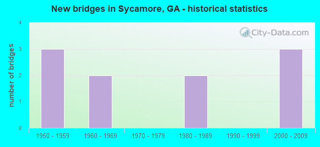
- New bridges - historical statistics
- 31950-1959
- 21960-1969
- 21980-1989
- 32000-2009


- Bridge Condition - Superstructure
- 50.0%Very good
- 50.0%Good

- Bridge Condition - Channel
- 40.0%Very good
- 60.0%Good
Find on map >> Show street view
Structure Number: 2870008, Location: 1.5 MI E OF SYCAMORE (Lat: 31.666258, Lng: -83.611089), Route carried "on" structure: State highway 32, Year Built: 1967, Status: Open, Structure Length: 3.84m (12.60ft), Average Daily Traffic: 1,020 (year 2011), Truck Traffic: 19%, Average Future Daily Traffic: 1,530 (year 2031), Design Load: HS 20, Features Intersected: HAT CREEK
Minimum Vertical Clearance: 30+ m (98+ ft), Kilometerpoint: 20.921, Lanes on structure: 2, Base Highway Network: Yes, Owner: State Highway Agency, Approaching Roadway Width: 7.0m (23.0ft), Material/Design: Steel continuous, Design/Construction: Stringer/Multi-beam, Number Of Spans In Main Unit: 6, Length of Maximum Span: 6.4m (21.0ft), Curb or Sidewalk Widths: Left: 0.6m (2.0ft), Right: 0.6m (2.0ft), Curb-To-Curb Width: 8.5m (27.9ft), Out-to-Out Width: 10.6m (34.8ft)
Condition: Deck: Good, Superstructure: Good, Substructure: Good, Channel: Very good, Operating Rating: 47.1 metric tons, Method Used To Determine Operating Rating: Allowable Stress (AS), Inventory Rating: 32.6 metric tons, Method Used To Determine Inventory Rating: Allowable Stress (AS), Structural Evaluation: Better than present minimum criteria, Deck Geometry: Somewhat better than minimum adequacy, Waterway Adequacy: Equal to present desirable criteria, Approach Roadway Alignment: Better than present minimum criteria, Designated Inspection Frequency: Every 24 months, Underwater Inspection Frequency: Every 60 months, Inspection Date: April 2021, Underwater Inspection Date: April 2018, Bridge Improvement Cost: $492,000, Roadway Improvement Cost: $49,000, Total Project Cost: $738,000, Deck Structure Type: Concrete Cast-file-Place
Find on map >> Show street view
Structure Number: 2870009, Location: 1.6 MI SE OF SYCAMORE (Lat: 31.665828, Lng: -83.607858), Route carried "on" structure: State highway 32, Year Built: 1958, Status: Open, Structure Length: 9.02m (29.59ft), Average Daily Traffic: 1,250 (year 2011), Truck Traffic: 1%, Average Future Daily Traffic: 1,875 (year 2031), Design Load: HS 20+Mod, Features Intersected: SR401(EXIT 78) @ 078.28N
Minimum Vertical Clearance: 30+ m (98+ ft), Kilometerpoint: 20.921, Lanes on structure: 2, Lanes under structure: 6, Base Highway Network: Yes, Owner: State Highway Agency, Approaching Roadway Width: 7.3m (24.0ft), Skew: 4 degrees, Material/Design: Prestressed concrete, Design/Construction: Stringer/Multi-beam, Number Of Spans In Main Unit: 4, Length of Maximum Span: 24.7m (81.0ft), Curb or Sidewalk Widths: Left: 0.6m (2.0ft), Right: 0.6m (2.0ft), Curb-To-Curb Width: 8.5m (27.9ft), Out-to-Out Width: 10.5m (34.4ft)
Condition: Deck: Good, Superstructure: Good, Substructure: Good, Operating Rating: 47.1 metric tons, Method Used To Determine Operating Rating: Allowable Stress (AS), Inventory Rating: 31.7 metric tons, Method Used To Determine Inventory Rating: Allowable Stress (AS), Structural Evaluation: Better than present minimum criteria, Deck Geometry: Somewhat better than minimum adequacy, Underclear: Meets minimum limits, Approach Roadway Alignment: Equal to present minimum criteria, Designated Inspection Frequency: Every 24 months, Inspection Date: April 2021, Other Special Inspection Date: May 2021, Bridge Improvement Cost: $1,141,000, Roadway Improvement Cost: $114,000, Total Project Cost: $1,711,000, Deck Structure Type: Concrete Cast-file-Place
Find on map >> Show street view
Structure Number: 287003, Location: 1 MI E OF SYCAMORE (Lat: 31.680858, Lng: -83.619847), Route carried "on" structure: Interstate 75, Year Built: 1958, Year Reconstructed: 2008, Status: Open, Structure Length: 4.97m (16.31ft), Average Daily Traffic: 33,700 (year 2011), Truck Traffic: 1%, Average Future Daily Traffic: 50,550 (year 2031), Design Load: HS 20+Mod, Features Intersected: CR 33 BUSSEY ROAD
Minimum Vertical Clearance: 30+ m (98+ ft), Kilometerpoint: 128.748, Lanes on structure: 6, Lanes under structure: 2, Base Highway Network: Yes, Owner: State Highway Agency, Approaching Roadway Width: 37.5m (123.0ft), Skew: 33 degrees, Material/Design: Prestressed concrete, Design/Construction: Stringer/Multi-beam, Number Of Spans In Main Unit: 3, Length of Maximum Span: 17.4m (57.1ft), Curb-To-Curb Width: 38.5m (126.3ft), Out-to-Out Width: 40.0m (131.2ft)
Condition: Deck: Good, Superstructure: Very good, Substructure: Good, Operating Rating: 70.7 metric tons, Method Used To Determine Operating Rating: Load Factor (LF), Inventory Rating: 35.3 metric tons, Method Used To Determine Inventory Rating: Load Factor (LF), Structural Evaluation: Better than present minimum criteria, Deck Geometry: Superior to present desirable criteria, Underclear: Somewhat better than minimum adequacy, Approach Roadway Alignment: Equal to present desirable criteria, Designated Inspection Frequency: Every 24 months, Inspection Date: April 2021, Bridge Improvement Cost: $1,332,000, Roadway Improvement Cost: $133,000, Total Project Cost: $1,997,000, Deck Structure Type: Concrete Cast-file-Place
Find on map >> Show street view
Structure Number: 2870038, Location: 2.5 MI SW OF SYCAMORE (Lat: 31.640997, Lng: -83.659158), Route carried "on" structure: County highway 1181, Year Built: 1961, Status: Posted for load, Structure Length: 3.90m (12.80ft), Average Daily Traffic: 890 (year 2011), Truck Traffic: 1%, Average Future Daily Traffic: 1,335 (year 2031), Design Load: H 15, Features Intersected: LITTLE RIVER, Facility Carried by Structure: CR 1148
Minimum Vertical Clearance: 30+ m (98+ ft), Kilometerpoint: 6.437, Lanes on structure: 2, Base Highway Network: Yes, Owner: County Highway Agency, Approaching Roadway Width: 7.9m (25.9ft), Material/Design: Concrete, Design/Construction: Tee Beam, Number Of Spans In Main Unit: 4, Length of Maximum Span: 9.8m (32.2ft), Curb or Sidewalk Widths: Left: 0.6m (2.0ft), Right: 0.6m (2.0ft), Curb-To-Curb Width: 7.9m (25.9ft), Out-to-Out Width: 9.8m (32.2ft)
Condition: Deck: Good, Superstructure: Good, Substructure: Good, Channel: Good, Operating Rating: 28.1 metric tons, Method Used To Determine Operating Rating: Load Factor (LF), Inventory Rating: 16.3 metric tons, Method Used To Determine Inventory Rating: Load Factor (LF), Structural Evaluation: Meets minimum limits, Deck Geometry: Somewhat better than minimum adequacy, Waterway Adequacy: Equal to present minimum criteria, Approach Roadway Alignment: Better than present minimum criteria, Bridge Posting: Required (Relationship of Operating Rating to Maximum Legal Load: 10.0 - 19.9% below), Designated Inspection Frequency: Every 24 months, Underwater Inspection Frequency: Every 60 months, Inspection Date: April 2021, Underwater Inspection Date: April 2018, Bridge Improvement Cost: $500,000, Roadway Improvement Cost: $50,000, Total Project Cost: $750,000, Deck Structure Type: Concrete Cast-file-Place
Find on map >> Show street view
Structure Number: 2870046, Location: .8 MI E OF SYCAMORE (Lat: 31.672058, Lng: -83.619989), Route carried "on" structure: County highway 1990, Year Built: 1958, Status: Open, Structure Length: 0.82m (2.69ft), Average Daily Traffic: 390 (year 2011), Truck Traffic: 1%, Average Future Daily Traffic: 585 (year 2031), Design Load: H 15, Features Intersected: HAT CREEK, Facility Carried by Structure: DENHAM ROAD
Minimum Vertical Clearance: 30+ m (98+ ft), Kilometerpoint: 1.609, Lanes on structure: 2, Base Highway Network: Yes, Owner: County Highway Agency, Approaching Roadway Width: 6.1m (20.0ft), Skew: 1 degrees, Material/Design: Concrete, Design/Construction: Culvert, Number Of Spans In Main Unit: 3, Length of Maximum Span: 2.4m (7.9ft)
Condition: Channel: Good, Culverts: Good, Operating Rating: 41.7 metric tons, Method Used To Determine Operating Rating: Field evaluation and documented engineering judgment, Inventory Rating: 24.4 metric tons, Method Used To Determine Inventory Rating: Field evaluation and documented engineering judgment, Structural Evaluation: Equal to present minimum criteria, Waterway Adequacy: Equal to present minimum criteria, Approach Roadway Alignment: Better than present minimum criteria, Designated Inspection Frequency: Every 24 months, Underwater Inspection Frequency: Every 60 months, Inspection Date: April 2021, Underwater Inspection Date: April 2018, Bridge Improvement Cost: $105,000, Roadway Improvement Cost: $11,000, Total Project Cost: $158,000
Find on map >> Show street view
Structure Number: 2875005, Location: 3.5 MI E OF ASHBURN (Lat: 31.704969, Lng: -83.591358), Route carried "on" structure: County highway 10, Year Built: 1980, Status: Open, Structure Length: 0.70m (2.30ft), Average Daily Traffic: 130 (year 2011), Truck Traffic: 1%, Average Future Daily Traffic: 195 (year 2031), Design Load: HS 20+Mod, Features Intersected: LAKE CREEK, Facility Carried by Structure: WEST ROAD
Minimum Vertical Clearance: 30+ m (98+ ft), Kilometerpoint: 1.609, Lanes on structure: 2, Base Highway Network: Yes, Owner: County Highway Agency, Approaching Roadway Width: 6.1m (20.0ft), Material/Design: Concrete, Design/Construction: Culvert, Number Of Spans In Main Unit: 3, Length of Maximum Span: 2.1m (6.9ft)
Condition: Channel: Good, Culverts: Good, Operating Rating: 55.3 metric tons, Method Used To Determine Operating Rating: Field evaluation and documented engineering judgment, Inventory Rating: 32.6 metric tons, Method Used To Determine Inventory Rating: Field evaluation and documented engineering judgment, Structural Evaluation: Better than present minimum criteria, Waterway Adequacy: Equal to present desirable criteria, Approach Roadway Alignment: Equal to present desirable criteria, Designated Inspection Frequency: Every 24 months, Inspection Date: April 2021, Bridge Improvement Cost: $90,000, Roadway Improvement Cost: $9,000, Total Project Cost: $135,000
Find on map >> Show street view
Structure Number: 2875032, Location: 2 MI SW OF SYCAMORE (Lat: 31.654819, Lng: -83.664189), Route carried "on" structure: County highway 204, Year Built: 1980, Status: Open, Structure Length: 4.88m (16.01ft), Average Daily Traffic: 160 (year 2011), Truck Traffic: 1%, Average Future Daily Traffic: 240 (year 2031), Design Load: HS 15, Features Intersected: LITTLE RIVER, Facility Carried by Structure: COFER ROAD
Minimum Vertical Clearance: 30+ m (98+ ft), Kilometerpoint: 1.609, Lanes on structure: 2, Base Highway Network: Yes, Owner: County Highway Agency, Approaching Roadway Width: 8.5m (27.9ft), Material/Design: Concrete, Design/Construction: Slab, Number Of Spans In Main Unit: 8, Length of Maximum Span: 6.1m (20.0ft), Curb-To-Curb Width: 9.9m (32.5ft), Out-to-Out Width: 10.7m (35.1ft)
Condition: Deck: Good, Superstructure: Good, Substructure: Good, Channel: Very good, Operating Rating: 39.0 metric tons, Method Used To Determine Operating Rating: Load Factor (LF), Inventory Rating: 23.5 metric tons, Method Used To Determine Inventory Rating: Load Factor (LF), Structural Evaluation: Equal to present minimum criteria, Deck Geometry: Better than present minimum criteria, Waterway Adequacy: Equal to present desirable criteria, Approach Roadway Alignment: Better than present minimum criteria, Designated Inspection Frequency: Every 24 months, Inspection Date: April 2021, Bridge Improvement Cost: $625,000, Roadway Improvement Cost: $63,000, Total Project Cost: $938,000, Deck Structure Type: Concrete Precast Panels
Find on map >> Show street view
Structure Number: 2875045, Location: 1.4 MI EAST OF SYCAMORE (Lat: 31.672047, Lng: -83.612858), Route carried "on" structure: County highway 1990, Year Built: 2006, Status: Open, Structure Length: 10.73m (35.20ft), Average Daily Traffic: 390 (year 2011), Truck Traffic: 1%, Average Future Daily Traffic: 585 (year 2031), Design Load: HS 20+Mod, Features Intersected: SR401@78.81N, Facility Carried by Structure: DENHAM ROAD
Minimum Vertical Clearance: 30+ m (98+ ft), Kilometerpoint: 1.609, Lanes on structure: 2, Lanes under structure: 6, Base Highway Network: Yes, Owner: State Highway Agency, Approaching Roadway Width: 7.0m (23.0ft), Skew: 3 degrees, Material/Design: Prestressed concrete, Design/Construction: Stringer/Multi-beam, Number Of Spans In Main Unit: 4, Length of Maximum Span: 37.5m (123.0ft), Curb-To-Curb Width: 9.1m (29.9ft), Out-to-Out Width: 10.1m (33.1ft)
Condition: Deck: Good, Superstructure: Very good, Substructure: Good, Operating Rating: 53.5 metric tons, Method Used To Determine Operating Rating: Allowable Stress (AS), Inventory Rating: 29.9 metric tons, Method Used To Determine Inventory Rating: Allowable Stress (AS), Structural Evaluation: Better than present minimum criteria, Deck Geometry: Equal to present minimum criteria, Underclear: Equal to present minimum criteria, Approach Roadway Alignment: Equal to present desirable criteria, Designated Inspection Frequency: Every 24 months, Inspection Date: April 2021, Bridge Improvement Cost: $1,379,000, Roadway Improvement Cost: $138,000, Total Project Cost: $2,069,000, Deck Structure Type: Concrete Cast-file-Place
Find on map >> Show street view
Structure Number: 2875046, Location: 1.5 MI NE OF SYCAMORE (Lat: 31.691369, Lng: -83.628089), Route carried "on" structure: County highway 11, Year Built: 2006, Status: Open, Structure Length: 9.91m (32.51ft), Average Daily Traffic: 430 (year 2011), Truck Traffic: 1%, Average Future Daily Traffic: 645 (year 2031), Design Load: HS 20+Mod, Features Intersected: SR401@80.42N, Facility Carried by Structure: AIRPORT ROAD
Minimum Vertical Clearance: 30+ m (98+ ft), Kilometerpoint: 3.219, Lanes on structure: 2, Lanes under structure: 6, Base Highway Network: Yes, Owner: State Highway Agency, Approaching Roadway Width: 6.1m (20.0ft), Skew: 3 degrees, Material/Design: Prestressed concrete, Design/Construction: Stringer/Multi-beam, Number Of Spans In Main Unit: 4, Length of Maximum Span: 34.1m (111.9ft), Curb-To-Curb Width: 9.1m (29.9ft), Out-to-Out Width: 10.1m (33.1ft)
Condition: Deck: Good, Superstructure: Very good, Substructure: Good, Operating Rating: 58.9 metric tons, Method Used To Determine Operating Rating: Allowable Stress (AS), Inventory Rating: 35.3 metric tons, Method Used To Determine Inventory Rating: Allowable Stress (AS), Structural Evaluation: Better than present minimum criteria, Deck Geometry: Equal to present minimum criteria, Underclear: Equal to present minimum criteria, Approach Roadway Alignment: Equal to present desirable criteria, Designated Inspection Frequency: Every 24 months, Inspection Date: April 2021, Bridge Improvement Cost: $1,270,000, Roadway Improvement Cost: $127,000, Total Project Cost: $1,905,000, Deck Structure Type: Concrete Cast-file-Place
Find on map >> Show street view
Structure Number: 2875049, Location: 3 MI SE OF SYCAMORE (Lat: 31.646189, Lng: -83.592119), Route carried "on" structure: County highway 35, Year Built: 2006, Status: Open, Structure Length: 10.36m (33.99ft), Average Daily Traffic: 50 (year 2011), Truck Traffic: 1%, Average Future Daily Traffic: 75 (year 2031), Design Load: HS 20+Mod, Features Intersected: SR401@076.65N, Facility Carried by Structure: ROBERT DAVIS ROAD
Minimum Vertical Clearance: 30+ m (98+ ft), Kilometerpoint: 3.219, Lanes on structure: 2, Lanes under structure: 6, Base Highway Network: Yes, Owner: State Highway Agency, Approaching Roadway Width: 7.3m (24.0ft), Skew: 3 degrees, Material/Design: Concrete, Design/Construction: Stringer/Multi-beam, Number Of Spans In Main Unit: 4, Length of Maximum Span: 36.9m (121.1ft), Curb-To-Curb Width: 9.1m (29.9ft), Out-to-Out Width: 10.1m (33.1ft)
Condition: Deck: Good, Superstructure: Very good, Substructure: Good, Operating Rating: 68.9 metric tons, Method Used To Determine Operating Rating: Allowable Stress (AS), Inventory Rating: 32.6 metric tons, Method Used To Determine Inventory Rating: Allowable Stress (AS), Structural Evaluation: Better than present minimum criteria, Deck Geometry: Better than present minimum criteria, Underclear: Equal to present minimum criteria, Approach Roadway Alignment: Better than present minimum criteria, Designated Inspection Frequency: Every 24 months, Inspection Date: April 2021, Bridge Improvement Cost: $1,328,000, Roadway Improvement Cost: $133,000, Total Project Cost: $1,993,000, Deck Structure Type: Concrete Cast-file-Place
Find on map >> Show street view
Structure Number: 2870009, Location: 1.6 MI SE OF SYCAMORE (Lat: 31.665828, Lng: -83.607858), Route carried "under" structure: Interstate 75, Structure Length: 0. m, Average Daily Traffic: 38,600 (year 1999), Truck Traffic: 1%, Features Intersected: SR 32, Facility Carried by Structure: SR 32
Minimum Vertical Clearance: 5.61m (18.41ft), Kilometerpoint: 125.529, Lanes on structure: 2, Length of Maximum Span: 0.0m
Find on map >> Show street view
Structure Number: 287003, Location: 1 MI E OF SYCAMORE (Lat: 31.680858, Lng: -83.619847), Route carried "under" structure: County highway 33, Structure Length: 0. m, Average Daily Traffic: 500 (year 1999), Truck Traffic: 1%, Features Intersected: I-75 (EXIT 80), Facility Carried by Structure: I-75
Minimum Vertical Clearance: 5.94m (19.49ft), Kilometerpoint: 0.000, Lanes on structure: 6, Length of Maximum Span: 0.0m
Find on map >> Show street view
Structure Number: 2875045, Location: 1.4 MI EAST OF SYCAMORE (Lat: 31.672047, Lng: -83.612858), Route carried "under" structure: Interstate 75, Structure Length: 0. m, Average Daily Traffic: 38,600 (year 1999), Truck Traffic: 10%, Features Intersected: FAS 1990 DENHAM, Facility Carried by Structure: DENHAM ROAD
Minimum Vertical Clearance: 5.38m (17.65ft), Kilometerpoint: 127.138, Lanes on structure: 2, Length of Maximum Span: 0.0m
Find on map >> Show street view
Structure Number: 2875046, Location: 1.5 MI NE OF SYCAMORE (Lat: 31.691369, Lng: -83.628089), Route carried "under" structure: Interstate 75, Structure Length: 0. m, Average Daily Traffic: 39,600 (year 1999), Truck Traffic: 4%, Features Intersected: CR 11 AIRPORT ROAD, Facility Carried by Structure: AIRPORT ROAD
Minimum Vertical Clearance: 6.07m (19.91ft), Kilometerpoint: 128.748, Lanes on structure: 2, Length of Maximum Span: 0.0m
Find on map >> Show street view
Structure Number: 2875049, Location: 3 MI SE OF SYCAMORE (Lat: 31.646189, Lng: -83.592119), Route carried "under" structure: Interstate 75, Structure Length: 0. m, Average Daily Traffic: 37,900 (year 1999), Truck Traffic: 3%, Features Intersected: CR 35 ROBERT DAVIS ROAD, Facility Carried by Structure: ROBERT DAVIS ROAD
Minimum Vertical Clearance: 5.13m (16.83ft), Kilometerpoint: 123.920, Lanes on structure: 2, Length of Maximum Span: 0.0m