Bridge Statistics for Syosset, New York (NY)
Condition, Traffic, Stress, Structural Evaluation, Project Costs
- National Bridge Inventory (NBI) Statistics
- 28Number of bridges
- 131ft / 40.0mTotal length
- $106,622,000Total costs
- 1,442,426Total average daily traffic
- 73,845Total average daily truck traffic
- National Bridge Inventory (NBI) Registered Bridges for Syosset
- No street view available for this location
- New bridges - historical statistics
- 11910-1919
- 61940-1949
- 21950-1959
- 101960-1969
- 91990-1999
- Reconstructed bridges - Historical Statistics
- 11980-1989
- 11990-1999
- Bridge Condition - Deck
- 7.7%Very good
- 30.8%Good
- 61.5%Satisfactory
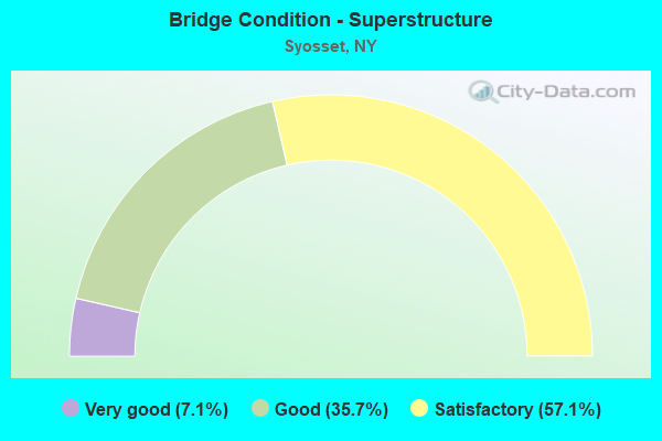
- Bridge Condition - Superstructure
- 7.1%Very good
- 35.7%Good
- 57.1%Satisfactory
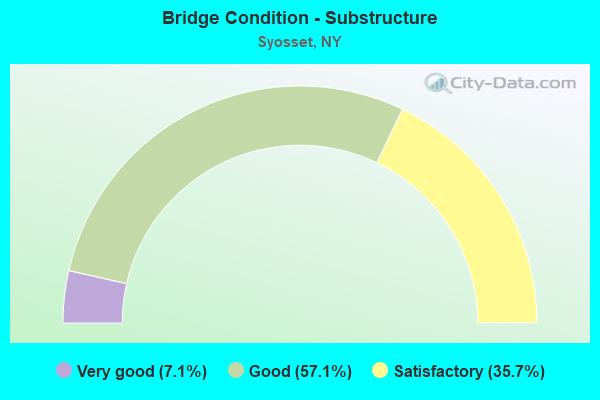
- Bridge Condition - Substructure
- 7.1%Very good
- 57.1%Good
- 35.7%Satisfactory
Find on map >> Show street view
Structure Number: 1037949, Location: .2 MI S JCT SH 135 & I495 (Lat: 40.796856, Lng: -73.487947), Route carried "on" structure: State highway 135, Year Built: 1962, Year Reconstructed: 1998, Status: Open, Structure Length: 3.08m (10.10ft), Average Daily Traffic: 62,232 (year 2019), Truck Traffic: 7%, Average Future Daily Traffic: 74,024 (year 2040), Design Load: HS 20, Features Intersected: WOODBURY ROAD
Minimum Vertical Clearance: 30+ m (98+ ft), Kilometerpoint: 15.237, Lanes on structure: 8, Lanes under structure: 5, Base Highway Network: Yes, Owner: State Highway Agency, Approaching Roadway Width: 36.0m (118.1ft), Skew: 22 degrees, Material/Design: Steel, Design/Construction: Stringer/Multi-beam, Number Of Spans In Main Unit: 1, Length of Maximum Span: 29.2m (95.8ft), Curb-To-Curb Width: 36.1m (118.4ft), Out-to-Out Width: 37.4m (122.7ft)
Condition: Deck: Good, Superstructure: Good, Substructure: Satisfactory, Operating Rating: 70.8 metric tons, Method Used To Determine Operating Rating: Load Factor (LF), Inventory Rating: 37.2 metric tons, Method Used To Determine Inventory Rating: Load Factor (LF), Structural Evaluation: Equal to present minimum criteria, Deck Geometry: Better than present minimum criteria, Underclear: Meets minimum limits, Approach Roadway Alignment: Equal to present desirable criteria, Length Of Structure Improvement: 3.07m (10.07ft), Designated Inspection Frequency: Every 24 months, Inspection Date: May 2021, Bridge Improvement Cost: $7,143,000, Roadway Improvement Cost: $4,183,000, Total Project Cost: $11,325,000 ( Estimate for 2021), Deck Structure Type: Concrete Cast-file-Place, Wearing Surface/Protective System: Wearing Surface: Monolithic Concrete
Find on map >> Show street view
Structure Number: 1037959, Location: JCT RTE 495+RTE 135 (Lat: 40.799353, Lng: -73.488603), Route carried "on" structure: State highway 135, Year Built: 1962, Status: Open, Structure Length: 4.75m (15.58ft), Average Daily Traffic: 62,232 (year 2019), Truck Traffic: 7%, Average Future Daily Traffic: 74,024 (year 2040), Design Load: HS 20, Features Intersected: 495I 495I 0302 1133 , E/
Minimum Vertical Clearance: 30+ m (98+ ft), Kilometerpoint: 15.511, Lanes on structure: 7, Lanes under structure: 10, Base Highway Network: Yes, Owner: State Highway Agency, Approaching Roadway Width: 34.1m (111.9ft), Skew: 21 degrees, Material/Design: Concrete continuous, Design/Construction: Frame, Number Of Spans In Main Unit: 2, Length of Maximum Span: 22.2m (72.8ft), Curb-To-Curb Width: 34.1m (111.9ft), Out-to-Out Width: 36.1m (118.4ft)
Condition: Deck: Satisfactory, Superstructure: Satisfactory, Substructure: Good, Operating Rating: 88.5 metric tons, Method Used To Determine Operating Rating: Field evaluation and documented engineering judgment, Inventory Rating: 32.7 metric tons, Method Used To Determine Inventory Rating: Field evaluation and documented engineering judgment, Structural Evaluation: Equal to present minimum criteria, Deck Geometry: Superior to present desirable criteria, Underclear: High priority of corrective action, Approach Roadway Alignment: Equal to present desirable criteria, Length Of Structure Improvement: 4.75m (15.58ft), Designated Inspection Frequency: Every 24 months, Inspection Date: July 2021, Bridge Improvement Cost: $8,697,000, Roadway Improvement Cost: $5,093,000, Total Project Cost: $13,790,000 ( Estimate for 2021), Wearing Surface/Protective System: Wearing Surface: Bituminous, Membrane: Preformed Fabric
Find on map >> Show street view
Structure Number: 1037969, Location: .3 MI N RTE 495+RTE 135 (Lat: 40.803047, Lng: -73.490028), Route carried "on" structure: State highway 135, Year Built: 1959, Status: Open, Structure Length: 1.62m (5.31ft), Average Daily Traffic: 39,791 (year 2019), Truck Traffic: 4%, Average Future Daily Traffic: 47,331 (year 2040), Design Load: H 20, Features Intersected: CROSSWAYS PARK W
Minimum Vertical Clearance: 30+ m (98+ ft), Kilometerpoint: 15.945, Lanes on structure: 7, Lanes under structure: 2, Base Highway Network: Yes, Owner: State Highway Agency, Approaching Roadway Width: 32.9m (107.9ft), Skew: 20 degrees, Material/Design: Steel, Design/Construction: Stringer/Multi-beam, Number Of Spans In Main Unit: 1, Length of Maximum Span: 14.6m (47.9ft), Curb-To-Curb Width: 32.8m (107.6ft), Out-to-Out Width: 35.1m (115.2ft)
Condition: Deck: Satisfactory, Superstructure: Good, Substructure: Satisfactory, Operating Rating: 78.9 metric tons, Method Used To Determine Operating Rating: Load Factor (LF), Inventory Rating: 47.2 metric tons, Method Used To Determine Inventory Rating: Load Factor (LF), Structural Evaluation: Equal to present minimum criteria, Deck Geometry: Better than present minimum criteria, Underclear: High priority of corrective action, Approach Roadway Alignment: Equal to present desirable criteria, Length Of Structure Improvement: 1.61m (5.28ft), Designated Inspection Frequency: Every 24 months, Inspection Date: April 2021, Bridge Improvement Cost: $4,449,000, Roadway Improvement Cost: $2,605,000, Total Project Cost: $7,054,000 ( Estimate for 2021), Deck Structure Type: Concrete Cast-file-Place, Wearing Surface/Protective System: Wearing Surface: Bituminous, Membrane: Preformed Fabric
Find on map >> Show street view
Structure Number: 1049191, Location: 1.3 MI E ROUTES 495I& 106 (Lat: 40.794931, Lng: -73.511375), Route carried "on" structure: Interstate 495, Year Built: 1990, Status: Open, Structure Length: 2.07m (6.79ft), Average Daily Traffic: 84,452 (year 2008), Truck Traffic: 13%, Design Load: HS 20, Features Intersected: ROBBINS LANE
Minimum Vertical Clearance: 30+ m (98+ ft), Kilometerpoint: 19.228, Lanes on structure: 5, Lanes under structure: 4, Base Highway Network: Yes, Owner: State Highway Agency, Approaching Roadway Width: 21.9m (71.9ft), Material/Design: Prestressed concrete, Design/Construction: Box Beam or Girders - Multiple, Number Of Spans In Main Unit: 1, Length of Maximum Span: 20.1m (65.9ft), Curb-To-Curb Width: 21.9m (71.9ft), Out-to-Out Width: 22.9m (75.1ft)
Condition: Deck: Satisfactory, Superstructure: Good, Substructure: Good, Operating Rating: 89.8 metric tons, Method Used To Determine Operating Rating: Load Factor (LF), Inventory Rating: 47.2 metric tons, Method Used To Determine Inventory Rating: Load Factor (LF), Structural Evaluation: Better than present minimum criteria, Deck Geometry: Meets minimum limits, Underclear: Meets minimum limits, Approach Roadway Alignment: Equal to present desirable criteria, Length Of Structure Improvement: 2.07m (6.79ft), Designated Inspection Frequency: Every 24 months, Inspection Date: October 2021, Bridge Improvement Cost: $2,883,000, Roadway Improvement Cost: $1,688,000, Total Project Cost: $4,572,000 ( Estimate for 2021), Wearing Surface/Protective System: Wearing Surface: Integral Concrete
Find on map >> Show street view
Structure Number: 1049192, Location: 1.3 M E RTS 106 & 495I EB (Lat: 40.794733, Lng: -73.511239), Route carried "on" structure: Interstate 495, Year Built: 1961, Year Reconstructed: 1991, Status: Open, Structure Length: 2.13m (6.99ft), Average Daily Traffic: 66,889 (year 2020), Truck Traffic: 14%, Average Future Daily Traffic: 70,233 (year 2040), Design Load: HS 20, Features Intersected: ROBBINS LANE
Minimum Vertical Clearance: 30+ m (98+ ft), Kilometerpoint: 19.228, Lanes on structure: 6, Lanes under structure: 4, Base Highway Network: Yes, Owner: State Highway Agency, Approaching Roadway Width: 34.1m (111.9ft), Skew: 20 degrees, Material/Design: Concrete, Design/Construction: Frame, Number Of Spans In Main Unit: 1, Length of Maximum Span: 20.1m (65.9ft), Curb or Sidewalk Widths: Left: 0.0m, Right: 1.1m (3.6ft), Curb-To-Curb Width: 34.2m (112.2ft), Out-to-Out Width: 43.1m (141.4ft)
Condition: Deck: Satisfactory, Superstructure: Satisfactory, Substructure: Good, Operating Rating: 89.8 metric tons, Method Used To Determine Operating Rating: Load Factor (LF), Inventory Rating: 52.6 metric tons, Method Used To Determine Inventory Rating: Load Factor (LF), Structural Evaluation: Equal to present minimum criteria, Deck Geometry: Superior to present desirable criteria, Underclear: High priority of corrective action, Approach Roadway Alignment: Equal to present desirable criteria, Length Of Structure Improvement: 2.13m (6.99ft), Designated Inspection Frequency: Every 24 months, Inspection Date: October 2021, Bridge Improvement Cost: $7,310,000, Roadway Improvement Cost: $4,281,000, Total Project Cost: $11,591,000 ( Estimate for 2021), Wearing Surface/Protective System: Wearing Surface: Monolithic Concrete
Find on map >> Show street view
Structure Number: 1049209, Location: 1.8 MI E JCT I495 & SH 10 (Lat: 40.797594, Lng: -73.503000), Route carried "on" structure: County highway , Year Built: 1996, Status: Open, Structure Length: 5.97m (19.59ft), Average Daily Traffic: 20,936 (year 2020), Truck Traffic: 4%, Average Future Daily Traffic: 25,433 (year 2040), Design Load: HS 25 or greater, Features Intersected: 495I495I03021125, RTE I4, Facility Carried by Structure: S OYSTER BAY ROAD
Minimum Vertical Clearance: 30+ m (98+ ft), Kilometerpoint: 5.583, Lanes on structure: 7, Lanes under structure: 10, Owner: State Highway Agency, Approaching Roadway Width: 24.7m (81.0ft), Skew: 2 degrees, Material/Design: Prestressed concrete, Design/Construction: Box Beam or Girders - Multiple, Number Of Spans In Main Unit: 2, Length of Maximum Span: 31.6m (103.7ft), Curb or Sidewalk Widths: Left: 2.4m (7.9ft), Right: 2.4m (7.9ft), Curb-To-Curb Width: 24.7m (81.0ft), Out-to-Out Width: 30.1m (98.8ft)
Condition: Deck: Satisfactory, Superstructure: Satisfactory, Substructure: Good, Operating Rating: 57.2 metric tons, Method Used To Determine Operating Rating: Load Factor (LF), Inventory Rating: 34.5 metric tons, Method Used To Determine Inventory Rating: Load Factor (LF), Structural Evaluation: Equal to present minimum criteria, Deck Geometry: High priority of replacement, Underclear: High priority of corrective action, Approach Roadway Alignment: Equal to present desirable criteria, Length Of Structure Improvement: 5.97m (19.59ft), Designated Inspection Frequency: Every 24 months, Inspection Date: October 2020, Bridge Improvement Cost: $6,865,000, Roadway Improvement Cost: $4,020,000, Total Project Cost: $10,886,000 ( Estimate for 2021), Deck Structure Type: Concrete Cast-file-Place, Wearing Surface/Protective System: Wearing Surface: Monolithic Concrete
Find on map >> Show street view
Structure Number: 1049219, Location: .3 MI W OF RTE 135+RT 495 (Lat: 40.798897, Lng: -73.495194), Route carried "on" structure: Interstate 495, Year Built: 1962, Status: Open, Structure Length: 1.49m (4.89ft), Average Daily Traffic: 163,063 (year 2020), Truck Traffic: 12%, Average Future Daily Traffic: 171,216 (year 2040), Design Load: HS 20+Mod, Features Intersected: GATEWAY DRIVE
Minimum Vertical Clearance: 30+ m (98+ ft), Kilometerpoint: 20.660, Lanes on structure: 11, Lanes under structure: 2, Base Highway Network: Yes, Owner: State Highway Agency, Approaching Roadway Width: 49.7m (163.1ft), Skew: 20 degrees, Material/Design: Concrete, Design/Construction: Frame, Number Of Spans In Main Unit: 1, Length of Maximum Span: 13.7m (44.9ft), Curb-To-Curb Width: 49.8m (163.4ft), Out-to-Out Width: 53.1m (174.2ft)
Condition: Deck: Satisfactory, Superstructure: Satisfactory, Substructure: Good, Operating Rating: 69.9 metric tons, Method Used To Determine Operating Rating: Load Factor (LF), Inventory Rating: 34.5 metric tons, Method Used To Determine Inventory Rating: Load Factor (LF), Structural Evaluation: Equal to present minimum criteria, Deck Geometry: Superior to present desirable criteria, Underclear: High priority of corrective action, Approach Roadway Alignment: Better than present minimum criteria, Length Of Structure Improvement: 1.49m (4.89ft), Designated Inspection Frequency: Every 24 months, Inspection Date: July 2020, Bridge Improvement Cost: $5,205,000, Roadway Improvement Cost: $3,048,000, Total Project Cost: $8,253,000 ( Estimate for 2021), Wearing Surface/Protective System: Wearing Surface: Monolithic Concrete
Find on map >> Show street view
Structure Number: 1058249, Location: 1.1 MI NE JCT NSP+RTE 107 (Lat: 40.791414, Lng: -73.515403), Route carried "on" structure: State highway 908G, Year Built: 1947, Status: Open, Structure Length: 1.76m (5.77ft), Average Daily Traffic: 66,160 (year 2018), Average Future Daily Traffic: 78,697 (year 2040), Design Load: H 20, Features Intersected: MILLER PLACE
Minimum Vertical Clearance: 30+ m (98+ ft), Kilometerpoint: 20.885, Lanes on structure: 4, Lanes under structure: 2, Base Highway Network: Yes, Owner: State Highway Agency, Approaching Roadway Width: 20.1m (65.9ft), Skew: 23 degrees, Material/Design: Concrete, Design/Construction: Frame, Number Of Spans In Main Unit: 1, Length of Maximum Span: 15.5m (50.9ft), Curb-To-Curb Width: 20.2m (66.3ft), Out-to-Out Width: 21.8m (71.5ft)
Condition: Deck: Very good, Superstructure: Very good, Substructure: Very good, Operating Rating: 56.5 metric tons, Method Used To Determine Operating Rating: Field evaluation and documented engineering judgment, Inventory Rating: 23.0 metric tons, Method Used To Determine Inventory Rating: Field evaluation and documented engineering judgment, Structural Evaluation: Somewhat better than minimum adequacy, Deck Geometry: Equal to present minimum criteria, Underclear: Meets minimum limits, Approach Roadway Alignment: Equal to present desirable criteria, Length Of Structure Improvement: 1.76m (5.77ft), Designated Inspection Frequency: Every 24 months, Inspection Date: Febuary 2020, Bridge Improvement Cost: $2,524,000, Roadway Improvement Cost: $1,478,000, Total Project Cost: $4,001,000 ( Estimate for 2021), Wearing Surface/Protective System: Wearing Surface: Bituminous
Find on map >> Show street view
Structure Number: 1058259, Location: 1.8 MI NE JCT NSP & SH107 (Lat: 40.793050, Lng: -73.503517), Route carried "on" structure: County highway , Year Built: 1947, Status: Open, Structure Length: 2.59m (8.50ft), Average Daily Traffic: 24,779 (year 2019), Truck Traffic: 2%, Average Future Daily Traffic: 30,101 (year 2040), Design Load: H 20, Features Intersected: 908G908G03011136 W/B, RT, Facility Carried by Structure: S OYSTER BAY ROAD
Minimum Vertical Clearance: 30+ m (98+ ft), Kilometerpoint: 5.101, Lanes on structure: 4, Lanes under structure: 4, Owner: State Highway Agency, Approaching Roadway Width: 14.6m (47.9ft), Skew: 1 degrees, Material/Design: Concrete, Design/Construction: Arch - Deck, Number Of Spans In Main Unit: 1, Length of Maximum Span: 24.0m (78.7ft), Curb or Sidewalk Widths: Left: 1.5m (4.9ft), Right: 1.5m (4.9ft), Curb-To-Curb Width: 14.6m (47.9ft), Out-to-Out Width: 18.6m (61.0ft)
Condition: Superstructure: Satisfactory, Substructure: Satisfactory, Operating Rating: 63.8 metric tons, Method Used To Determine Operating Rating: Field evaluation and documented engineering judgment, Inventory Rating: 24.3 metric tons, Method Used To Determine Inventory Rating: Field evaluation and documented engineering judgment, Structural Evaluation: Equal to present minimum criteria, Deck Geometry: High priority of replacement, Underclear: High priority of corrective action, Approach Roadway Alignment: Equal to present desirable criteria, Length Of Structure Improvement: 2.59m (8.50ft), Designated Inspection Frequency: Every 24 months, Inspection Date: Febuary 2020, Bridge Improvement Cost: $3,886,000, Roadway Improvement Cost: $2,276,000, Total Project Cost: $6,161,000 ( Estimate for 2021), Wearing Surface/Protective System: Wearing Surface: Bituminous
Find on map >> Show street view
Structure Number: 105826, Location: .1 MI W JCT RTE 495+ NSP (Lat: 40.795128, Lng: -73.489936), Route carried "on" structure: County highway , Year Built: 1946, Status: Open, Structure Length: 2.77m (9.09ft), Average Daily Traffic: 13,225 (year 2019), Truck Traffic: 2%, Average Future Daily Traffic: 16,065 (year 2040), Design Load: H 20, Features Intersected: 908G908G03011144, RTE 90, Facility Carried by Structure: WOODBURY ROAD
Minimum Vertical Clearance: 30+ m (98+ ft), Kilometerpoint: 4.264, Lanes on structure: 4, Lanes under structure: 4, Owner: State Highway Agency, Approaching Roadway Width: 14.6m (47.9ft), Skew: 3 degrees, Material/Design: Concrete, Design/Construction: Frame, Number Of Spans In Main Unit: 1, Length of Maximum Span: 24.6m (80.7ft), Curb or Sidewalk Widths: Left: 1.5m (4.9ft), Right: 1.5m (4.9ft), Curb-To-Curb Width: 14.6m (47.9ft), Out-to-Out Width: 18.6m (61.0ft)
Condition: Deck: Satisfactory, Superstructure: Satisfactory, Substructure: Good, Operating Rating: 64.7 metric tons, Method Used To Determine Operating Rating: Field evaluation and documented engineering judgment, Inventory Rating: 24.5 metric tons, Method Used To Determine Inventory Rating: Field evaluation and documented engineering judgment, Structural Evaluation: Equal to present minimum criteria, Deck Geometry: High priority of replacement, Underclear: High priority of corrective action, Approach Roadway Alignment: Equal to present desirable criteria, Length Of Structure Improvement: 2.77m (9.09ft), Designated Inspection Frequency: Every 24 months, Inspection Date: March 2020, Bridge Improvement Cost: $2,884,000, Roadway Improvement Cost: $1,689,000, Total Project Cost: $4,572,000 ( Estimate for 2021), Wearing Surface/Protective System: Wearing Surface: Bituminous, Membrane: Preformed Fabric
Find on map >> Show street view
Structure Number: 1060851, Location: JCT RTE 135+RTE 25 (Lat: 40.811858, Lng: -73.491628), Route carried "on" structure: State highway 25, Year Built: 1962, Status: Open, Structure Length: 4.18m (13.71ft), Average Daily Traffic: 17,061 (year 2020), Truck Traffic: 4%, Average Future Daily Traffic: 19,685 (year 2040), Design Load: H 20, Features Intersected: 135 135 03011116, N/B, R
Minimum Vertical Clearance: 30+ m (98+ ft), Kilometerpoint: 22.365, Lanes on structure: 3, Lanes under structure: 6, Base Highway Network: Yes, Owner: State Highway Agency, Approaching Roadway Width: 14.9m (48.9ft), Skew: 1 degrees, Material/Design: Steel, Design/Construction: Stringer/Multi-beam, Number Of Spans In Main Unit: 2, Length of Maximum Span: 20.1m (65.9ft), Curb or Sidewalk Widths: Left: 1.8m (5.9ft), Right: 0.6m (2.0ft), Curb-To-Curb Width: 14.9m (48.9ft), Out-to-Out Width: 17.8m (58.4ft)
Condition: Deck: Good, Superstructure: Good, Substructure: Satisfactory, Operating Rating: 88.9 metric tons, Method Used To Determine Operating Rating: Load Factor (LF), Inventory Rating: 53.5 metric tons, Method Used To Determine Inventory Rating: Load Factor (LF), Structural Evaluation: Equal to present minimum criteria, Deck Geometry: Equal to present minimum criteria, Underclear: High priority of corrective action, Approach Roadway Alignment: Equal to present desirable criteria, Length Of Structure Improvement: 4.17m (13.68ft), Designated Inspection Frequency: Every 24 months, Inspection Date: June 2021, Bridge Improvement Cost: $4,095,000, Roadway Improvement Cost: $2,398,000, Total Project Cost: $6,493,000 ( Estimate for 2021), Deck Structure Type: Concrete Cast-file-Place, Wearing Surface/Protective System: Wearing Surface: Bituminous
Find on map >> Show street view
Structure Number: 107721, Location: 0.1 MI W JCT RT I495 &135 (Lat: 40.799500, Lng: -73.490958), Route carried "on" structure: Interstate 495, Year Built: 1997, Status: Open, Structure Length: 2.26m (7.41ft), Average Daily Traffic: 163,063 (year 2020), Truck Traffic: 12%, Average Future Daily Traffic: 171,216 (year 2040), Design Load: HS 25 or greater, Features Intersected: RTE I495
Minimum Vertical Clearance: 30+ m (98+ ft), Kilometerpoint: 20.981, Lanes on structure: 9, Lanes under structure: 2, Base Highway Network: Yes, Owner: State Highway Agency, Approaching Roadway Width: 42.4m (139.1ft), Skew: 20 degrees, Material/Design: Prestressed concrete, Design/Construction: Box Beam or Girders - Multiple, Number Of Spans In Main Unit: 1, Length of Maximum Span: 21.9m (71.9ft), Curb-To-Curb Width: 42.4m (139.1ft), Out-to-Out Width: 44.2m (145.0ft)
Condition: Deck: Good, Superstructure: Satisfactory, Substructure: Good, Operating Rating: 58.1 metric tons, Method Used To Determine Operating Rating: Load Factor (LF), Inventory Rating: 45.4 metric tons, Method Used To Determine Inventory Rating: Load Factor (LF), Structural Evaluation: Equal to present minimum criteria, Deck Geometry: Superior to present desirable criteria, Underclear: High priority of corrective action, Approach Roadway Alignment: Equal to present desirable criteria, Length Of Structure Improvement: 2.25m (7.38ft), Designated Inspection Frequency: Every 24 months, Inspection Date: September 2020, Bridge Improvement Cost: $5,422,000, Roadway Improvement Cost: $3,175,000, Total Project Cost: $8,597,000 ( Estimate for 2021), Wearing Surface/Protective System: Wearing Surface: Integral Concrete
Find on map >> Show street view
Structure Number: 107722, Location: 0.1 MI N JCT RT I495 &135 (Lat: 40.801108, Lng: -73.489378), Route carried "on" structure: State highway 135, Year Built: 1996, Status: Open, Structure Length: 2.26m (7.41ft), Average Daily Traffic: 39,791 (year 2019), Truck Traffic: 4%, Average Future Daily Traffic: 47,331 (year 2040), Design Load: HS 25 or greater, Features Intersected: RTE I495
Minimum Vertical Clearance: 30+ m (98+ ft), Kilometerpoint: 15.639, Lanes on structure: 6, Lanes under structure: 2, Base Highway Network: Yes, Owner: State Highway Agency, Approaching Roadway Width: 31.4m (103.0ft), Skew: 20 degrees, Material/Design: Prestressed concrete, Design/Construction: Box Beam or Girders - Multiple, Number Of Spans In Main Unit: 1, Length of Maximum Span: 22.2m (72.8ft), Curb-To-Curb Width: 31.3m (102.7ft), Out-to-Out Width: 33.2m (108.9ft)
Condition: Deck: Good, Superstructure: Good, Substructure: Good, Operating Rating: 62.6 metric tons, Method Used To Determine Operating Rating: Load Factor (LF), Inventory Rating: 48.1 metric tons, Method Used To Determine Inventory Rating: Load Factor (LF), Structural Evaluation: Better than present minimum criteria, Deck Geometry: Superior to present desirable criteria, Underclear: High priority of corrective action, Approach Roadway Alignment: Equal to present desirable criteria, Length Of Structure Improvement: 2.25m (7.38ft), Designated Inspection Frequency: Every 24 months, Inspection Date: September 2020, Bridge Improvement Cost: $4,282,000, Roadway Improvement Cost: $2,508,000, Total Project Cost: $6,790,000 ( Estimate for 2021), Wearing Surface/Protective System: Wearing Surface: Integral Concrete
Find on map >> Show street view
Structure Number: 226111, Location: 1 MILE EAST OF SYOSSET (Lat: 40.827539, Lng: -73.480928), Route carried "on" structure: Other road , Year Built: 1911, Status: Posted for load, Structure Length: 3.05m (10.01ft), Average Daily Traffic: 6,582 (year 2020), Truck Traffic: 3%, Average Future Daily Traffic: 8,143 (year 2040), Features Intersected: LIRR PT JEFF BRCH, Facility Carried by Structure: SOUTH WOODS ROAD
Minimum Vertical Clearance: 30+ m (98+ ft), Kilometerpoint: 1.480, Lanes on structure: 2, Owner: Town or Township Highway Agency, Approaching Roadway Width: 7.3m (24.0ft), Material/Design: Steel, Design/Construction: Stringer/Multi-beam, Number Of Spans In Main Unit: 3, Length of Maximum Span: 9.4m (30.8ft), Curb or Sidewalk Widths: Left: 0.9m (3.0ft), Right: 0.0m, Curb-To-Curb Width: 7.3m (24.0ft), Out-to-Out Width: 10.1m (33.1ft)
Condition: Deck: Satisfactory, Superstructure: Satisfactory, Substructure: Satisfactory, Operating Rating: 49.0 metric tons, Method Used To Determine Operating Rating: Load Factor (LF), Inventory Rating: 29.0 metric tons, Method Used To Determine Inventory Rating: Load Factor (LF), Structural Evaluation: Equal to present minimum criteria, Deck Geometry: High priority of replacement, Underclear: High priority of corrective action, Approach Roadway Alignment: Meets minimum limits, Bridge Posting: Required (Relationship of Operating Rating to Maximum Legal Load: > 39.9% below), Length Of Structure Improvement: 3.04m (9.97ft), Designated Inspection Frequency: Every 12 months, Inspection Date: August 2021, Bridge Improvement Cost: $1,600,000, Roadway Improvement Cost: $937,000, Total Project Cost: $2,537,000 ( Estimate for 2021), Deck Structure Type: Concrete Cast-file-Place, Wearing Surface/Protective System: Wearing Surface: Bituminous
Find on map >> Show street view
Structure Number: 1037949, Location: .2 MI S JCT SH 135 & I495 (Lat: 40.796856, Lng: -73.487947), Route carried "under" structure: County highway , Year Built: 1962, Structure Length: 0. m, Average Daily Traffic: 17,863 (year 2005), Features Intersected: WOODBURY ROAD, Facility Carried by Structure: RTE 135
Minimum Vertical Clearance: 4.55m (14.93ft), Kilometerpoint: 0.000, Lanes on structure: 8, Lanes under structure: 5, Material/Design: Steel, Design/Construction: Stringer/Multi-beam, Length of Maximum Span: 29.2m (95.8ft)
Find on map >> Show street view
Structure Number: 1037959, Location: JCT RTE 495+RTE 135 (Lat: 40.799353, Lng: -73.488603), Route carried "under" structure: Interstate 495, Year Built: 1962, Structure Length: 0. m, Average Daily Traffic: 151,793 (year 2002), Features Intersected: 495I 495I 0302 1133 , E/, Facility Carried by Structure: RTE 135
Minimum Vertical Clearance: 5.16m (16.93ft), Kilometerpoint: 21.303, Lanes on structure: 7, Lanes under structure: 5, Material/Design: Concrete continuous, Design/Construction: Frame, Length of Maximum Span: 22.2m (72.8ft)
Find on map >> Show street view
Structure Number: 1037969, Location: .3 MI N RTE 495+RTE 135 (Lat: 40.803047, Lng: -73.490028), Route carried "under" structure: Other road , Year Built: 1959, Structure Length: 0. m, Average Daily Traffic: 4,000 (year 2021), Features Intersected: CROSSWAYS PARK W, Facility Carried by Structure: RTE 135
Minimum Vertical Clearance: 4.42m (14.50ft), Kilometerpoint: 0.000, Lanes on structure: 7, Lanes under structure: 2, Material/Design: Steel, Design/Construction: Stringer/Multi-beam, Length of Maximum Span: 14.6m (47.9ft)
Find on map >> Show street view
Structure Number: 1049191, Location: 1.3 MI E ROUTES 495I& 106 (Lat: 40.794931, Lng: -73.511375), Route carried "under" structure: Other road , Year Built: 1990, Structure Length: 0. m, Average Daily Traffic: 5,500 (year 2021), Features Intersected: ROBBINS LANE, Facility Carried by Structure: RTE I495
Minimum Vertical Clearance: 5.99m (19.65ft), Kilometerpoint: 0.000, Lanes on structure: 5, Lanes under structure: 4, Material/Design: Prestressed concrete, Design/Construction: Box Beam or Girders - Multiple, Length of Maximum Span: 20.1m (65.9ft)
Find on map >> Show street view
Structure Number: 1049192, Location: 1.3 M E RTS 106 & 495I EB (Lat: 40.794733, Lng: -73.511239), Route carried "under" structure: Other road , Year Built: 1961, Structure Length: 0. m, Average Daily Traffic: 5,500 (year 2021), Features Intersected: ROBBINS LANE, Facility Carried by Structure: RTE I495
Minimum Vertical Clearance: 4.47m (14.67ft), Kilometerpoint: 0.000, Lanes on structure: 6, Lanes under structure: 4, Material/Design: Concrete, Design/Construction: Frame, Length of Maximum Span: 20.1m (65.9ft)
Find on map >> Show street view
Structure Number: 1049209, Location: 1.8 MI E JCT I495 & SH 10 (Lat: 40.797594, Lng: -73.503000), Route carried "under" structure: Interstate 495, Year Built: 1996, Structure Length: 0. m, Average Daily Traffic: 151,793 (year 2002), Features Intersected: 495I495I03021125, RTE I4, Facility Carried by Structure: S OYSTER BAY ROAD
Minimum Vertical Clearance: 5.02m (16.47ft), Kilometerpoint: 19.936, Lanes on structure: 7, Lanes under structure: 5, Material/Design: Prestressed concrete, Design/Construction: Box Beam or Girders - Multiple, Length of Maximum Span: 31.6m (103.7ft)
Find on map >> Show street view
Structure Number: 1049219, Location: .3 MI W OF RTE 135+RT 495 (Lat: 40.798897, Lng: -73.495194), Route carried "under" structure: Other road , Year Built: 1962, Structure Length: 0. m, Average Daily Traffic: 2,800 (year 2021), Features Intersected: GATEWAY DRIVE, Facility Carried by Structure: RTE I495
Minimum Vertical Clearance: 4.36m (14.30ft), Kilometerpoint: 0.000, Lanes on structure: 11, Lanes under structure: 2, Material/Design: Concrete, Design/Construction: Frame, Length of Maximum Span: 13.7m (44.9ft)
Find on map >> Show street view
Structure Number: 1058249, Location: 1.1 MI NE JCT NSP+RTE 107 (Lat: 40.791414, Lng: -73.515403), Route carried "under" structure: Other road , Year Built: 1947, Structure Length: 0. m, Average Daily Traffic: 6,000 (year 1976), Features Intersected: MILLER PLACE, Facility Carried by Structure: RTE 908G
Minimum Vertical Clearance: 4.72m (15.49ft), Kilometerpoint: 0.000, Lanes on structure: 4, Lanes under structure: 2, Material/Design: Concrete, Design/Construction: Frame, Length of Maximum Span: 15.5m (50.9ft)
Find on map >> Show street view
Structure Number: 1058259, Location: 1.8 MI NE JCT NSP & SH107 (Lat: 40.793050, Lng: -73.503517), Route carried "under" structure: State highway 908G, Year Built: 1947, Structure Length: 0. m, Average Daily Traffic: 98,634 (year 2002), Features Intersected: 908G908G03011136 W/B, RT, Facility Carried by Structure: S OYSTER BAY ROAD
Minimum Vertical Clearance: 4.32m (14.17ft), Kilometerpoint: 22.027, Lanes on structure: 4, Lanes under structure: 2, Material/Design: Concrete, Design/Construction: Arch - Deck, Length of Maximum Span: 24.0m (78.7ft)
Find on map >> Show street view
Structure Number: 105826, Location: .1 MI W JCT RTE 495+ NSP (Lat: 40.795128, Lng: -73.489936), Route carried "under" structure: State highway 908G, Year Built: 1946, Structure Length: 0. m, Average Daily Traffic: 98,634 (year 2002), Features Intersected: 908G908G03011144, RTE 90, Facility Carried by Structure: WOODBURY ROAD
Minimum Vertical Clearance: 4.27m (14.01ft), Kilometerpoint: 23.218, Lanes on structure: 4, Lanes under structure: 2, Material/Design: Concrete, Design/Construction: Frame, Length of Maximum Span: 24.6m (80.7ft)
Find on map >> Show street view
Structure Number: 1060851, Location: JCT RTE 135+RTE 25 (Lat: 40.811858, Lng: -73.491628), Route carried "under" structure: State highway 135, Year Built: 1962, Structure Length: 0. m, Average Daily Traffic: 27,200 (year 1973), Features Intersected: 135 135 03011116, N/B, R, Facility Carried by Structure: RTE 25
Minimum Vertical Clearance: 4.60m (15.09ft), Kilometerpoint: 17.200, Lanes on structure: 3, Lanes under structure: 3, Material/Design: Steel, Design/Construction: Stringer/Multi-beam, Length of Maximum Span: 20.1m (65.9ft)
Find on map >> Show street view
Structure Number: 107721, Location: 0.1 MI W JCT RT I495 &135 (Lat: 40.799500, Lng: -73.490958), Route carried "under" structure: Ramp Other road 495, Year Built: 1997, Structure Length: 0. m, Average Daily Traffic: 5,000 (year 2021), Features Intersected: RTE I495
Minimum Vertical Clearance: 4.72m (15.49ft), Kilometerpoint: 0.000, Lanes on structure: 9, Lanes under structure: 2, Material/Design: Prestressed concrete, Design/Construction: Box Beam or Girders - Multiple, Length of Maximum Span: 21.9m (71.9ft)
Find on map >> Show street view
Structure Number: 107722, Location: 0.1 MI N JCT RT I495 &135 (Lat: 40.801108, Lng: -73.489378), Route carried "under" structure: Ramp Other road 495, Year Built: 1996, Structure Length: 0. m, Average Daily Traffic: 5,000 (year 2021), Features Intersected: RTE I495, Facility Carried by Structure: RTE 135
Minimum Vertical Clearance: 4.72m (15.49ft), Kilometerpoint: 0.000, Lanes on structure: 6, Lanes under structure: 2, Material/Design: Prestressed concrete, Design/Construction: Box Beam or Girders - Multiple, Length of Maximum Span: 22.2m (72.8ft)
Find on map >> Show street view
Structure Number: 706084, Location: 1.6 MI NE RT 25 & RT 106 (Lat: 40.809769, Lng: -73.512714), Route carried "under" structure: State highway 25, Year Built: 1996, Structure Length: 0. m, Average Daily Traffic: 32,453 (year 1998), Features Intersected: RTE 25, Facility Carried by Structure: LONG ISLAND
Minimum Vertical Clearance: 4.67m (15.32ft), Kilometerpoint: 21.384, Lanes under structure: 7, Material/Design: Steel, Design/Construction: Girder and Floorbeam System, Length of Maximum Span: 36.5m (119.8ft)