Bridge Statistics for Table Rock, Missouri (MO)
Condition, Traffic, Stress, Structural Evaluation, Project Costs
- National Bridge Inventory (NBI) Statistics
- 13Number of bridges
- 312ft / 95.5mTotal length
- $12,173,000Total costs
- 173,947Total average daily traffic
- 24,789Total average daily truck traffic
- 258,531Total future (year 2041) average daily traffic
- National Bridge Inventory (NBI) Registered Bridges for Table Rock
- No street view available for this location
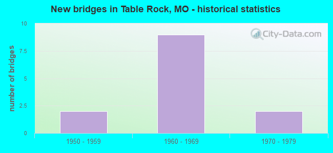
- New bridges - historical statistics
- 21950-1959
- 91960-1969
- 21970-1979

- Reconstructed bridges - Historical Statistics
- 21980-1989
- 01990-1999
- 32000-2009
- 32010-2019
- 12020-2022


- Bridge Condition - Deck
- 16.7%Excellent
- 16.7%Very good
- 8.3%Good
- 50.0%Satisfactory
- 8.3%Fair

- Bridge Condition - Superstructure
- 8.3%Excellent
- 41.7%Good
- 33.3%Satisfactory
- 8.3%Fair
- 8.3%Poor

- Bridge Condition - Substructure
- 33.3%Good
- 58.3%Satisfactory
- 8.3%Fair

- Bridge Condition - Channel
- 11.1%Very good
- 33.3%Good
- 44.4%Satisfactory
- 11.1%Fair
Find on map >> Show street view
Structure Number: 1702, Location: S 4 T 50 N R 33 W (Lat: 39.166544, Lng: -94.613075), Route carried "on" structure: State highway 9, Year Built: 1969, Year Reconstructed: 1989, Status: Open, Structure Length: 4.15m (13.62ft), Average Daily Traffic: 6,697 (year 2021), Truck Traffic: 6%, Average Future Daily Traffic: 13,729 (year 2041), Design Load: H 20, Features Intersected: CST RVRWAY BLVD, US 69
Minimum Vertical Clearance: 30+ m (98+ ft), Kilometerpoint: 14.146, Lanes on structure: 2, Lanes under structure: 2, Base Highway Network: Yes, Owner: State Highway Agency, Approaching Roadway Width: 11.6m (38.1ft), Skew: 1 degrees, Material/Design: Steel continuous, Design/Construction: Stringer/Multi-beam, Number Of Spans In Main Unit: 3, Length of Maximum Span: 17.1m (56.1ft), Curb-To-Curb Width: 11.6m (38.1ft), Out-to-Out Width: 12.4m (40.7ft)
Condition: Deck: Fair, Superstructure: Good, Substructure: Satisfactory, Operating Rating: 72.9 metric tons, Method Used To Determine Operating Rating: Load Factor (LF), Inventory Rating: 44.1 metric tons, Method Used To Determine Inventory Rating: Load Factor (LF), Structural Evaluation: Equal to present minimum criteria, Deck Geometry: Equal to present minimum criteria, Underclear: Equal to present minimum criteria, Approach Roadway Alignment: Equal to present desirable criteria, Designated Inspection Frequency: Every 24 months, Inspection Date: October 2020, Deck Structure Type: Concrete Cast-file-Place, Wearing Surface/Protective System: Wearing Surface: Bituminous
Find on map >> Show street view
Structure Number: 1735, Location: S 4 T 40 N R 2 W (Lat: 38.224844, Lng: -91.155583), Route carried "on" structure: State highway AF, Year Built: 1969, Year Reconstructed: 2011, Status: Open, Structure Length: 5.94m (19.49ft), Average Daily Traffic: 2,318 (year 2021), Truck Traffic: 12%, Average Future Daily Traffic: 4,404 (year 2041), Design Load: H 20, Features Intersected: IS 44
Minimum Vertical Clearance: 30+ m (98+ ft), Kilometerpoint: 5.448, Lanes on structure: 5, Lanes under structure: 4, Owner: State Highway Agency, Approaching Roadway Width: 23.2m (76.1ft), Material/Design: Steel continuous, Design/Construction: Stringer/Multi-beam, Number Of Spans In Main Unit: 4, Length of Maximum Span: 18.3m (60.0ft), Curb-To-Curb Width: 23.2m (76.1ft), Out-to-Out Width: 24.0m (78.7ft)
Condition: Deck: Satisfactory, Superstructure: Satisfactory, Substructure: Satisfactory, Operating Rating: 39.6 metric tons, Method Used To Determine Operating Rating: Load Factor (LF), Inventory Rating: 23.4 metric tons, Method Used To Determine Inventory Rating: Load Factor (LF), Structural Evaluation: Equal to present minimum criteria, Deck Geometry: Better than present minimum criteria, Underclear: Somewhat better than minimum adequacy, Approach Roadway Alignment: Equal to present desirable criteria, Designated Inspection Frequency: Every 24 months, Inspection Date: October 2021, Deck Structure Type: Concrete Cast-file-Place, Wearing Surface/Protective System: Wearing Surface: Monolithic Concrete
Find on map >> Show street view
Structure Number: 1739, Location: S 5 T 57 N R 19 W (Lat: 39.795503, Lng: -93.062539), Route carried "on" structure: State highway 11, Year Built: 1968, Status: Open, Structure Length: 4.82m (15.81ft), Average Daily Traffic: 959 (year 2021), Truck Traffic: 12%, Average Future Daily Traffic: 1,199 (year 2041), Design Load: H 20, Features Intersected: LONG BR OVRFL
Minimum Vertical Clearance: 30+ m (98+ ft), Kilometerpoint: 115.199, Lanes on structure: 2, Owner: State Highway Agency, Approaching Roadway Width: 11.6m (38.1ft), Material/Design: Concrete continuous, Design/Construction: Slab, Number Of Spans In Main Unit: 3, Length of Maximum Span: 18.6m (61.0ft), Curb-To-Curb Width: 11.6m (38.1ft), Out-to-Out Width: 12.4m (40.7ft)
Condition: Deck: Satisfactory, Superstructure: Satisfactory, Substructure: Fair, Channel: Satisfactory, Operating Rating: 40.5 metric tons, Method Used To Determine Operating Rating: Allowable Stress (AS), Inventory Rating: 22.5 metric tons, Method Used To Determine Inventory Rating: Allowable Stress (AS), Structural Evaluation: Somewhat better than minimum adequacy, Deck Geometry: Better than present minimum criteria, Waterway Adequacy: Equal to present desirable criteria, Approach Roadway Alignment: Equal to present desirable criteria, Designated Inspection Frequency: Every 24 months, Inspection Date: September 2020, Deck Structure Type: Concrete Cast-file-Place, Wearing Surface/Protective System: Wearing Surface: Bituminous
Find on map >> Show street view
Structure Number: 1745, Location: S 4 T 24 N R 13 W (Lat: 36.792442, Lng: -92.402667), Route carried "on" structure: State highway N, Year Built: 1967, Status: Open, Structure Length: 5.97m (19.59ft), Average Daily Traffic: 224 (year 2021), Truck Traffic: 11%, Average Future Daily Traffic: 358 (year 2041), Design Load: H 15, Features Intersected: SPRING CR
Minimum Vertical Clearance: 30+ m (98+ ft), Kilometerpoint: 24.765, Lanes on structure: 2, Owner: State Highway Agency, Approaching Roadway Width: 6.1m (20.0ft), Skew: 3 degrees, Material/Design: Steel continuous, Design/Construction: Stringer/Multi-beam, Number Of Spans In Main Unit: 3, Length of Maximum Span: 24.4m (80.1ft), Curb-To-Curb Width: 7.9m (25.9ft), Out-to-Out Width: 8.7m (28.5ft)
Condition: Deck: Satisfactory, Superstructure: Good, Substructure: Good, Channel: Fair, Operating Rating: 27.0 metric tons, Method Used To Determine Operating Rating: Allowable Stress (AS), Inventory Rating: 17.1 metric tons, Method Used To Determine Inventory Rating: Allowable Stress (AS), Structural Evaluation: Somewhat better than minimum adequacy, Deck Geometry: Somewhat better than minimum adequacy, Waterway Adequacy: Equal to present desirable criteria, Approach Roadway Alignment: Equal to present minimum criteria, Designated Inspection Frequency: Every 24 months, Inspection Date: January 2022, Deck Structure Type: Concrete Cast-file-Place, Wearing Surface/Protective System: Wearing Surface: Bituminous
Find on map >> Show street view
Structure Number: 1746, Location: S 4 T 34 N R 26 W (Lat: 37.734981, Lng: -93.779706), Route carried "on" structure: State highway J, Year Built: 1967, Year Reconstructed: 2012, Status: Open, Structure Length: 24.11m (79.10ft), Average Daily Traffic: 1,010 (year 2021), Truck Traffic: 11%, Average Future Daily Traffic: 1,465 (year 2041), Design Load: H 15, Features Intersected: SAC RVR
Minimum Vertical Clearance: 30+ m (98+ ft), Kilometerpoint: 22.392, Lanes on structure: 2, Owner: State Highway Agency, Approaching Roadway Width: 6.1m (20.0ft), Material/Design: Steel continuous, Design/Construction: Stringer/Multi-beam, Number Of Spans In Main Unit: 3, Number Of Approach Spans: 6, Length of Maximum Span: 48.8m (160.1ft), Curb-To-Curb Width: 7.9m (25.9ft), Out-to-Out Width: 8.7m (28.5ft)
Condition: Deck: Good, Superstructure: Poor, Substructure: Good, Channel: Satisfactory, Operating Rating: 28.8 metric tons, Method Used To Determine Operating Rating: Load Factor (LF), Inventory Rating: 17.1 metric tons, Method Used To Determine Inventory Rating: Load Factor (LF), Structural Evaluation: Meets minimum limits, Deck Geometry: Meets minimum limits, Waterway Adequacy: Equal to present desirable criteria, Approach Roadway Alignment: Equal to present minimum criteria, Length Of Structure Improvement: 2.41m (7.91ft), Designated Inspection Frequency: Every 24 months, Inspection Date: June 2021, Bridge Improvement Cost: $3,517,000, Roadway Improvement Cost: $352,000, Total Project Cost: $5,275,000 ( Estimate for 2022), Deck Structure Type: Concrete Cast-file-Place, Wearing Surface/Protective System: Wearing Surface: Monolithic Concrete, Deck Protection: Epoxy Coated Reinforcing
Find on map >> Show street view
Structure Number: 1752, Location: S 26 T 45 N R 32 W (Lat: 38.690139, Lng: -94.426936), Route carried "on" structure: Interstate 49, Year Built: 1968, Year Reconstructed: 2018, Status: Open, Structure Length: 3.81m (12.50ft), Average Daily Traffic: 19,216 (year 2021), Truck Traffic: 20%, Average Future Daily Traffic: 33,628 (year 2041), Design Load: HS 20, Features Intersected: S GRAND RVR
Minimum Vertical Clearance: 30+ m (98+ ft), Kilometerpoint: 30.936, Lanes on structure: 2, Base Highway Network: Yes, Owner: State Highway Agency, Approaching Roadway Width: 11.6m (38.1ft), Material/Design: Steel continuous, Design/Construction: Stringer/Multi-beam, Number Of Spans In Main Unit: 3, Length of Maximum Span: 14.9m (48.9ft), Curb-To-Curb Width: 11.6m (38.1ft), Out-to-Out Width: 12.4m (40.7ft)
Condition: Deck: Excellent, Superstructure: Good, Substructure: Satisfactory, Channel: Satisfactory, Operating Rating: 62.1 metric tons, Method Used To Determine Operating Rating: Load Factor (LF), Inventory Rating: 36.9 metric tons, Method Used To Determine Inventory Rating: Load Factor (LF), Structural Evaluation: Equal to present minimum criteria, Deck Geometry: Equal to present minimum criteria, Waterway Adequacy: Equal to present desirable criteria, Approach Roadway Alignment: Equal to present desirable criteria, Designated Inspection Frequency: Every 24 months, Inspection Date: November 2021, Deck Structure Type: Concrete Cast-file-Place, Wearing Surface/Protective System: Wearing Surface: Monolithic Concrete, Deck Protection: Epoxy Coated Reinforcing
Find on map >> Show street view
Structure Number: 2241, Location: S 24 T 41 N R 9 W (Lat: 39.178539, Lng: -91.873506), Route carried "on" structure: State highway J, Year Built: 1970, Status: Open, Structure Length: 0.83m (2.72ft), Average Daily Traffic: 2,671 (year 2021), Truck Traffic: 7%, Average Future Daily Traffic: 4,140 (year 2041), Design Load: H 20, Features Intersected: CR
Minimum Vertical Clearance: 30+ m (98+ ft), Kilometerpoint: 0.908, Lanes on structure: 2, Owner: State Highway Agency, Approaching Roadway Width: 17.1m (56.1ft), Skew: 2 degrees, Material/Design: Concrete continuous, Design/Construction: Culvert, Number Of Spans In Main Unit: 2, Length of Maximum Span: 3.7m (12.1ft)
Condition: Channel: Satisfactory, Culverts: Satisfactory, Operating Rating: 96.3 metric tons, Method Used To Determine Operating Rating: Load Factor (LF), Inventory Rating: 57.6 metric tons, Method Used To Determine Inventory Rating: Load Factor (LF), Structural Evaluation: Equal to present minimum criteria, Waterway Adequacy: Equal to present minimum criteria, Approach Roadway Alignment: Equal to present desirable criteria, Designated Inspection Frequency: Every 24 months, Inspection Date: October 2021
Find on map >> Show street view
Structure Number: 2242, Location: S 4 T 39 N R 5 E (Lat: 38.135906, Lng: -90.471475), Route carried "on" structure: State highway 110, Year Built: 1975, Status: Open, Structure Length: 6.74m (22.11ft), Average Daily Traffic: 12,086 (year 2021), Truck Traffic: 7%, Average Future Daily Traffic: 20,546 (year 2041), Design Load: H 20, Features Intersected: US 67
Minimum Vertical Clearance: 30+ m (98+ ft), Kilometerpoint: 10.083, Lanes on structure: 2, Lanes under structure: 4, Base Highway Network: Yes, Owner: State Highway Agency, Approaching Roadway Width: 11.6m (38.1ft), Skew: 2 degrees, Material/Design: Steel continuous, Design/Construction: Stringer/Multi-beam, Number Of Spans In Main Unit: 4, Length of Maximum Span: 19.8m (65.0ft), Curb-To-Curb Width: 13.4m (44.0ft), Out-to-Out Width: 14.2m (46.6ft)
Condition: Deck: Satisfactory, Superstructure: Satisfactory, Substructure: Satisfactory, Operating Rating: 40.5 metric tons, Method Used To Determine Operating Rating: Load Factor (LF), Inventory Rating: 24.3 metric tons, Method Used To Determine Inventory Rating: Load Factor (LF), Structural Evaluation: Equal to present minimum criteria, Deck Geometry: Equal to present minimum criteria, Underclear: Equal to present minimum criteria, Approach Roadway Alignment: Equal to present desirable criteria, Designated Inspection Frequency: Every 24 months, Inspection Date: December 2020, Deck Structure Type: Concrete Cast-file-Place, Wearing Surface/Protective System: Wearing Surface: Other
Find on map >> Show street view
Structure Number: 689, Location: S 6 T 23 N R 12 E (Lat: 36.671464, Lng: -89.791600), Route carried "on" structure: State highway Z, Year Built: 1957, Year Reconstructed: 2019, Status: Open, Structure Length: 2.22m (7.28ft), Average Daily Traffic: 175 (year 2021), Truck Traffic: 15%, Average Future Daily Traffic: 245 (year 2041), Features Intersected: MAIN DRAIN DTCH
Minimum Vertical Clearance: 30+ m (98+ ft), Kilometerpoint: 16.135, Lanes on structure: 2, Owner: State Highway Agency, Approaching Roadway Width: 7.3m (24.0ft), Skew: 1 degrees, Material/Design: Steel continuous, Design/Construction: Stringer/Multi-beam, Number Of Spans In Main Unit: 3, Length of Maximum Span: 8.5m (27.9ft), Curb-To-Curb Width: 7.3m (24.0ft), Out-to-Out Width: 8.1m (26.6ft)
Condition: Deck: Excellent, Superstructure: Excellent, Substructure: Satisfactory, Channel: Good, Operating Rating: 84.6 metric tons, Method Used To Determine Operating Rating: Load Factor (LF), Inventory Rating: 50.4 metric tons, Method Used To Determine Inventory Rating: Load Factor (LF), Structural Evaluation: Equal to present minimum criteria, Deck Geometry: Somewhat better than minimum adequacy, Waterway Adequacy: Equal to present desirable criteria, Approach Roadway Alignment: Equal to present desirable criteria, Designated Inspection Frequency: Every 24 months, Inspection Date: October 2021, Deck Structure Type: Concrete Cast-file-Place, Wearing Surface/Protective System: Wearing Surface: Monolithic Concrete, Deck Protection: Epoxy Coated Reinforcing
Find on map >> Show street view
Structure Number: 69, Location: S 14 T 55 N R 35 W (Lat: 39.571764, Lng: -94.788364), Route carried "on" structure: Interstate 29, Year Built: 1958, Year Reconstructed: 1988, Status: Open, Structure Length: 6.95m (22.80ft), Average Daily Traffic: 12,343 (year 2021), Truck Traffic: 28%, Average Future Daily Traffic: 20,983 (year 2041), Design Load: HS 20+Mod, Features Intersected: BEE CR
Minimum Vertical Clearance: 30+ m (98+ ft), Kilometerpoint: 61.813, Lanes on structure: 2, Base Highway Network: Yes, Owner: State Highway Agency, Approaching Roadway Width: 11.6m (38.1ft), Skew: 3 degrees, Material/Design: Concrete, Design/Construction: Tee Beam, Number Of Spans In Main Unit: 5, Length of Maximum Span: 17.5m (57.4ft), Curb or Sidewalk Widths: Left: 0.2m (0.7ft), Right: 0.2m (0.7ft), Curb-To-Curb Width: 11.5m (37.7ft), Out-to-Out Width: 12.3m (40.4ft)
Condition: Deck: Satisfactory, Superstructure: Satisfactory, Substructure: Satisfactory, Channel: Very good, Operating Rating: 57.6 metric tons, Method Used To Determine Operating Rating: Load Factor (LF), Inventory Rating: 34.2 metric tons, Method Used To Determine Inventory Rating: Load Factor (LF), Structural Evaluation: Equal to present minimum criteria, Deck Geometry: Somewhat better than minimum adequacy, Waterway Adequacy: Equal to present desirable criteria, Approach Roadway Alignment: Equal to present desirable criteria, Designated Inspection Frequency: Every 24 months, Inspection Date: August 2020, Deck Structure Type: Concrete Cast-file-Place, Wearing Surface/Protective System: Wearing Surface: Monolithic Concrete, Deck Protection: Internally Sealed
Find on map >> Show street view
Structure Number: 852, Location: S 18 T 44 N R 7 E (Lat: 38.553139, Lng: -90.270794), Route carried "on" structure: Interstate 55, Year Built: 1963, Year Reconstructed: 2005, Status: Posted for load, Structure Length: 17.01m (55.81ft), Average Daily Traffic: 98,830 (year 2021), Truck Traffic: 12%, Average Future Daily Traffic: 123,538 (year 2041), Design Load: HS 20+Mod, Features Intersected: RIVER DES PERES, CST GER
Minimum Vertical Clearance: 30+ m (98+ ft), Kilometerpoint: 12.035, Lanes on structure: 8, Lanes under structure: 8, Base Highway Network: Yes, Owner: State Highway Agency, Approaching Roadway Width: 39.6m (129.9ft), Skew: 20 degrees, Material/Design: Steel, Design/Construction: Stringer/Multi-beam, Number Of Spans In Main Unit: 5, Number Of Approach Spans: 2, Length of Maximum Span: 30.2m (99.1ft), Curb or Sidewalk Widths: Left: 0.2m (0.7ft), Right: 0.2m (0.7ft), Curb-To-Curb Width: 38.6m (126.6ft), Out-to-Out Width: 39.5m (129.6ft)
Condition: Deck: Satisfactory, Superstructure: Fair, Substructure: Satisfactory, Channel: Good, Operating Rating: 48.6 metric tons, Method Used To Determine Operating Rating: Load Factor (LF), Inventory Rating: 29.7 metric tons, Method Used To Determine Inventory Rating: Load Factor (LF), Structural Evaluation: Somewhat better than minimum adequacy, Deck Geometry: Superior to present desirable criteria, Underclear: High priority of corrective action, Waterway Adequacy: Equal to present desirable criteria, Approach Roadway Alignment: Equal to present desirable criteria, Length Of Structure Improvement: 1.77m (5.81ft), Designated Inspection Frequency: Every 24 months, Other Special Inspection Frequency: Every 24 months, Inspection Date: March 2020, Other Special Inspection Date: March 2020, Bridge Improvement Cost: $4,599,000, Roadway Improvement Cost: $460,000, Total Project Cost: $6,898,000 ( Estimate for 2022), Deck Structure Type: Concrete Cast-file-Place, Wearing Surface/Protective System: Wearing Surface: Latex Concrete, Deck Protection: Cathodic Protection
Find on map >> Show street view
Structure Number: 854, Location: S 13 T 57 N R 30 W (Lat: 39.753619, Lng: -94.219919), Route carried "on" structure: US 36, Year Built: 1963, Year Reconstructed: 2017, Status: Open, Structure Length: 6.80m (22.31ft), Average Daily Traffic: 6,011 (year 2021), Truck Traffic: 17%, Average Future Daily Traffic: 12,623 (year 2041), Design Load: H 20, Features Intersected: IS 35
Minimum Vertical Clearance: 30+ m (98+ ft), Kilometerpoint: 55.675, Lanes on structure: 2, Lanes under structure: 4, Base Highway Network: Yes, Owner: State Highway Agency, Approaching Roadway Width: 12.2m (40.0ft), Material/Design: Steel continuous, Design/Construction: Stringer/Multi-beam, Number Of Spans In Main Unit: 4, Length of Maximum Span: 20.1m (65.9ft), Curb-To-Curb Width: 12.5m (41.0ft), Out-to-Out Width: 13.0m (42.7ft)
Condition: Deck: Very good, Superstructure: Good, Substructure: Good, Operating Rating: 37.8 metric tons, Method Used To Determine Operating Rating: Load Factor (LF), Inventory Rating: 22.5 metric tons, Method Used To Determine Inventory Rating: Load Factor (LF), Structural Evaluation: Somewhat better than minimum adequacy, Deck Geometry: Better than present minimum criteria, Underclear: Somewhat better than minimum adequacy, Approach Roadway Alignment: Equal to present desirable criteria, Designated Inspection Frequency: Every 24 months, Inspection Date: December 2021, Deck Structure Type: Concrete Cast-file-Place, Wearing Surface/Protective System: Deck Protection: Epoxy Coated Reinforcing
Find on map >> Show street view
Structure Number: 857, Location: S 1 T 56 N R 5 W (Lat: 39.678986, Lng: -91.410967), Route carried "on" structure: US 61, Year Built: 1963, Year Reconstructed: 2020, Status: Open, Structure Length: 6.13m (20.11ft), Average Daily Traffic: 11,407 (year 2021), Truck Traffic: 23%, Average Future Daily Traffic: 21,673 (year 2041), Design Load: H 20, Features Intersected: BEAR CR
Minimum Vertical Clearance: 30+ m (98+ ft), Kilometerpoint: 531.843, Lanes on structure: 2, Base Highway Network: Yes, Owner: State Highway Agency, Approaching Roadway Width: 8.5m (27.9ft), Material/Design: Steel continuous, Design/Construction: Stringer/Multi-beam, Number Of Spans In Main Unit: 3, Length of Maximum Span: 23.8m (78.1ft), Curb-To-Curb Width: 9.1m (29.9ft), Out-to-Out Width: 10.0m (32.8ft)
Condition: Deck: Very good, Superstructure: Good, Substructure: Good, Channel: Good, Operating Rating: 50.4 metric tons, Method Used To Determine Operating Rating: Load Factor (LF), Inventory Rating: 29.7 metric tons, Method Used To Determine Inventory Rating: Load Factor (LF), Structural Evaluation: Better than present minimum criteria, Deck Geometry: Meets minimum limits, Waterway Adequacy: Equal to present desirable criteria, Approach Roadway Alignment: Equal to present desirable criteria, Designated Inspection Frequency: Every 24 months, Inspection Date: November 2021, Deck Structure Type: Concrete Cast-file-Place, Wearing Surface/Protective System: Wearing Surface: Monolithic Concrete, Deck Protection: Epoxy Coated Reinforcing