Bridge Statistics for Tallmadge, Ohio (OH)
Condition, Traffic, Stress, Structural Evaluation, Project Costs
- National Bridge Inventory (NBI) Statistics
- 11Number of bridges
- 125ft / 38.3mTotal length
- 308,857Total average daily traffic
- 29,190Total average daily truck traffic
- National Bridge Inventory (NBI) Registered Bridges for Tallmadge
- No street view available for this location
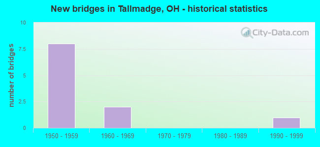
- New bridges - historical statistics
- 81950-1959
- 21960-1969
- 11990-1999

- Reconstructed bridges - Historical Statistics
- 11980-1989
- 41990-1999


- Bridge Condition - Deck
- 16.7%Very good
- 66.7%Good
- 16.7%Satisfactory

- Bridge Condition - Superstructure
- 33.3%Very good
- 33.3%Good
- 33.3%Satisfactory

- Bridge Condition - Substructure
- 50.0%Very good
- 50.0%Good
Find on map >> Show street view
Structure Number: 6701922, Location: 1.73 MI W OF SR 43 (Lat: 41.099989, Lng: -81.377019), Route carried "on" structure: Interstate 76, Year Built: 1964, Year Reconstructed: 2004, Status: Open, Structure Length: 6.77m (22.21ft), Average Daily Traffic: 45,925 (year 2015), Truck Traffic: 19%, Average Future Daily Traffic: 63,744 (year 2035), Design Load: HS 25 or greater, Features Intersected: OVER TALLMADGE RD CR-18
Minimum Vertical Clearance: 30+ m (98+ ft), Kilometerpoint: 2.108, Lanes on structure: 4, Lanes under structure: 4, Base Highway Network: Yes, Owner: State Highway Agency, Approaching Roadway Width: 14.9m (48.9ft), Skew: 33 degrees, Material/Design: Steel continuous, Design/Construction: Stringer/Multi-beam, Number Of Spans In Main Unit: 4, Number Of Approach Spans: 2, Length of Maximum Span: 18.3m (60.0ft), Curb-To-Curb Width: 36.6m (120.1ft), Out-to-Out Width: 38.6m (126.6ft)
Condition: Deck: Good, Superstructure: Good, Substructure: Good, Operating Rating: 42.1 metric tons, Method Used To Determine Operating Rating: Allowable Stress (AS) rating reported by rating factor (RF) method using MS18 loading, Inventory Rating: 32.4 metric tons, Method Used To Determine Inventory Rating: Allowable Stress (AS) rating reported by rating factor (RF) method using MS18 loading, Structural Evaluation: Better than present minimum criteria, Deck Geometry: Superior to present desirable criteria, Underclear: Somewhat better than minimum adequacy, Approach Roadway Alignment: Somewhat better than minimum adequacy, Designated Inspection Frequency: Every 24 months, Inspection Date: March 2021, Deck Structure Type: Concrete Cast-file-Place, Wearing Surface/Protective System: Wearing Surface: Monolithic Concrete, Deck Protection: Epoxy Coated Reinforcing
Find on map >> Show street view
Structure Number: 7706693, Location: 0.65 MI W OF SR 532 (Lat: 41.070681, Lng: -81.417219), Route carried "on" structure: County highway C0080, Year Built: 1958, Year Reconstructed: 1998, Status: Open, Structure Length: 8.11m (26.61ft), Average Daily Traffic: 1,997 (year 2015), Truck Traffic: 5%, Average Future Daily Traffic: 83,771 (year 2035), Design Load: HS 20+Mod, Features Intersected: I-76, Facility Carried by Structure: MUNROE FALLS ROAD
Minimum Vertical Clearance: 30+ m (98+ ft), Kilometerpoint: 1.368, Lanes on structure: 2, Lanes under structure: 4, Owner: State Highway Agency, Approaching Roadway Width: 10.4m (34.1ft), Skew: 3 degrees, Material/Design: Steel continuous, Design/Construction: Stringer/Multi-beam, Number Of Spans In Main Unit: 4, Length of Maximum Span: 22.3m (73.2ft), Curb-To-Curb Width: 8.5m (27.9ft), Out-to-Out Width: 11.3m (37.1ft)
Condition: Deck: Good, Superstructure: Satisfactory, Substructure: Good, Operating Rating: 38.9 metric tons, Method Used To Determine Operating Rating: Load and Resistance Factor Rating (LRFR) rating reported by rating factor(RF) method using HL-93 loadings, Inventory Rating: 32.4 metric tons, Method Used To Determine Inventory Rating: Load and Resistance Factor Rating (LRFR) rating reported by rating factor(RF) method using HL-93 loadings, Structural Evaluation: Equal to present minimum criteria, Deck Geometry: Somewhat better than minimum adequacy, Underclear: High priority of corrective action, Approach Roadway Alignment: Equal to present desirable criteria, Designated Inspection Frequency: Every 12 months, Inspection Date: July 2021, Deck Structure Type: Concrete Cast-file-Place, Wearing Surface/Protective System: Wearing Surface: Monolithic Concrete, Deck Protection: Epoxy Coated Reinforcing
Find on map >> Show street view
Structure Number: 7706723, Location: 0.47 MI W OF SR 532 (Lat: 41.072269, Lng: -81.414181), Route carried "on" structure: County highway C0654, Year Built: 1958, Year Reconstructed: 1992, Status: Open, Structure Length: 12.16m (39.90ft), Average Daily Traffic: 2,438 (year 2015), Truck Traffic: 5%, Average Future Daily Traffic: 83,771 (year 2035), Design Load: HS 20, Features Intersected: I-76, Facility Carried by Structure: NEWTON STREET
Minimum Vertical Clearance: 30+ m (98+ ft), Kilometerpoint: 6.711, Lanes on structure: 2, Lanes under structure: 4, Owner: State Highway Agency, Approaching Roadway Width: 10.4m (34.1ft), Skew: 5 degrees, Material/Design: Steel continuous, Design/Construction: Stringer/Multi-beam, Number Of Spans In Main Unit: 4, Length of Maximum Span: 35.1m (115.2ft), Curb-To-Curb Width: 10.4m (34.1ft), Out-to-Out Width: 11.3m (37.1ft)
Condition: Deck: Satisfactory, Superstructure: Satisfactory, Substructure: Good, Operating Rating: 42.1 metric tons, Method Used To Determine Operating Rating: Load Factor (LF) rating reported by rating factor (RF) method using MS18 loading, Inventory Rating: 32.4 metric tons, Method Used To Determine Inventory Rating: Load Factor (LF) rating reported by rating factor (RF) method using MS18 loading, Structural Evaluation: Equal to present minimum criteria, Deck Geometry: Somewhat better than minimum adequacy, Underclear: High priority of corrective action, Approach Roadway Alignment: Equal to present desirable criteria, Designated Inspection Frequency: Every 12 months, Inspection Date: July 2021, Deck Structure Type: Concrete Cast-file-Place, Wearing Surface/Protective System: Wearing Surface: Monolithic Concrete, Deck Protection: Epoxy Coated Reinforcing
Find on map >> Show street view
Structure Number: 7706758, Location: JCT OF IR 76 AND SR 532 (Lat: 41.076000, Lng: -81.406681), Route carried "on" structure: Interstate 76, Year Built: 1958, Year Reconstructed: 2002, Status: Open, Structure Length: 5.26m (17.26ft), Average Daily Traffic: 53,121 (year 2015), Truck Traffic: 8%, Average Future Daily Traffic: 73,732 (year 2035), Design Load: HS 20+Mod, Features Intersected: OVER SUM-SR 532-3.56
Minimum Vertical Clearance: 30+ m (98+ ft), Kilometerpoint: 27.294, Lanes on structure: 4, Lanes under structure: 4, Base Highway Network: Yes, Owner: State Highway Agency, Approaching Roadway Width: 15.2m (49.9ft), Skew: 31 degrees, Material/Design: Steel continuous, Design/Construction: Stringer/Multi-beam, Number Of Spans In Main Unit: 3, Length of Maximum Span: 21.3m (69.9ft), Curb-To-Curb Width: 15.2m (49.9ft), Out-to-Out Width: 38.1m (125.0ft)
Condition: Deck: Very good, Superstructure: Very good, Substructure: Very good, Operating Rating: 42.1 metric tons, Method Used To Determine Operating Rating: Allowable Stress (AS) rating reported by rating factor (RF) method using MS18 loading, Inventory Rating: 32.4 metric tons, Method Used To Determine Inventory Rating: Allowable Stress (AS) rating reported by rating factor (RF) method using MS18 loading, Structural Evaluation: Equal to present desirable criteria, Deck Geometry: High priority of replacement, Underclear: Somewhat better than minimum adequacy, Approach Roadway Alignment: Equal to present desirable criteria, Designated Inspection Frequency: Every 24 months, Inspection Date: July 2021, Deck Structure Type: Concrete Cast-file-Place, Wearing Surface/Protective System: Wearing Surface: Monolithic Concrete, Deck Protection: Epoxy Coated Reinforcing
Find on map >> Show street view
Structure Number: 7706812, Location: 0.72 MI E OF SR 532 (Lat: 41.083139, Lng: -81.396089), Route carried "on" structure: Interstate 76, Year Built: 1958, Year Reconstructed: 2002, Status: Open, Structure Length: 5.32m (17.45ft), Average Daily Traffic: 60,354 (year 2015), Truck Traffic: 8%, Average Future Daily Traffic: 83,771 (year 2035), Design Load: HS 20+Mod, Features Intersected: OVER EASTWOOD AVE CR-653
Minimum Vertical Clearance: 30+ m (98+ ft), Kilometerpoint: 28.534, Lanes on structure: 4, Lanes under structure: 2, Base Highway Network: Yes, Owner: State Highway Agency, Approaching Roadway Width: 15.2m (49.9ft), Skew: 33 degrees, Material/Design: Steel continuous, Design/Construction: Stringer/Multi-beam, Number Of Spans In Main Unit: 3, Length of Maximum Span: 19.8m (65.0ft), Curb-To-Curb Width: 15.2m (49.9ft), Out-to-Out Width: 37.8m (124.0ft)
Condition: Deck: Good, Superstructure: Very good, Substructure: Very good, Operating Rating: 64.8 metric tons, Method Used To Determine Operating Rating: Load and Resistance Factor Rating (LRFR) rating reported by rating factor(RF) method using HL-93 loadings, Inventory Rating: 51.8 metric tons, Method Used To Determine Inventory Rating: Load and Resistance Factor Rating (LRFR) rating reported by rating factor(RF) method using HL-93 loadings, Structural Evaluation: Equal to present desirable criteria, Deck Geometry: High priority of replacement, Underclear: Somewhat better than minimum adequacy, Approach Roadway Alignment: Equal to present desirable criteria, Designated Inspection Frequency: Every 24 months, Inspection Date: July 2021, Deck Structure Type: Concrete Cast-file-Place, Wearing Surface/Protective System: Wearing Surface: Monolithic Concrete, Deck Protection: Epoxy Coated Reinforcing
Find on map >> Show street view
Structure Number: 7757042, Location: 1.3 MI. NW. OF TALL. CIR. (Lat: 41.114750, Lng: -81.459569), Route carried "on" structure: City street M0532, Year Built: 1991, Status: Open, Structure Length: 0.70m (2.30ft), Average Daily Traffic: 9,117 (year 2018), Truck Traffic: 7%, Average Future Daily Traffic: 12,654 (year 2038), Design Load: HS 20+Mod, Features Intersected: KELSEY DITCH, Facility Carried by Structure: NORTHWEST AVE
Minimum Vertical Clearance: 30+ m (98+ ft), Kilometerpoint: 12.521, Lanes on structure: 2, Owner: County Highway Agency, Approaching Roadway Width: 9.8m (32.2ft), Skew: 2 degrees, Material/Design: Concrete, Design/Construction: Frame, Number Of Spans In Main Unit: 1, Length of Maximum Span: 6.4m (21.0ft), Curb-To-Curb Width: 9.8m (32.2ft), Out-to-Out Width: 9.8m (32.2ft)
Condition: Deck: Good, Superstructure: Good, Substructure: Very good, Channel: Good, Operating Rating: 40.8 metric tons, Method Used To Determine Operating Rating: Field evaluation and documented engineering judgment, Inventory Rating: 32.7 metric tons, Method Used To Determine Inventory Rating: Field evaluation and documented engineering judgment, Structural Evaluation: Better than present minimum criteria, Deck Geometry: Meets minimum limits, Waterway Adequacy: Superior to present desirable criteria, Approach Roadway Alignment: Equal to present desirable criteria, Designated Inspection Frequency: Every 24 months, Inspection Date: March 2021, Deck Structure Type: Concrete Cast-file-Place, Wearing Surface/Protective System: Wearing Surface: Bituminous, Membrane: Built-up, Deck Protection: Other Coated Reinforcing
Find on map >> Show street view
Structure Number: 6701922, Location: 1.73 MI W OF SR 43 (Lat: 41.099989, Lng: -81.377019), Route carried "under" structure: County highway 18, Year Built: 1964, Structure Length: 0. m, Average Daily Traffic: 9,435 (year 2015), Truck Traffic: 7%, Features Intersected: IR 76, Facility Carried by Structure: IR 76
Minimum Vertical Clearance: 4.72m (15.49ft), Kilometerpoint: 1.304, Lanes on structure: 4, Lanes under structure: 4, Material/Design: Steel continuous, Design/Construction: Stringer/Multi-beam, Length of Maximum Span: 18.3m (60.0ft)
Find on map >> Show street view
Structure Number: 7706693, Location: 0.65 MI W OF SR 532 (Lat: 41.070681, Lng: -81.417219), Route carried "under" structure: Interstate 76, Year Built: 1958, Structure Length: 0. m, Average Daily Traffic: 60,354 (year 2015), Truck Traffic: 8%, Features Intersected: UNDER MUNROE FALLS RD, Facility Carried by Structure: MUNROE FALLS ROAD
Minimum Vertical Clearance: 5.26m (17.26ft), Kilometerpoint: 26.281, Lanes on structure: 2, Lanes under structure: 4, Material/Design: Steel continuous, Design/Construction: Stringer/Multi-beam, Length of Maximum Span: 22.3m (73.2ft)
Find on map >> Show street view
Structure Number: 7706723, Location: 0.47 MI W OF SR 532 (Lat: 41.072269, Lng: -81.414181), Route carried "under" structure: Interstate 76, Year Built: 1958, Structure Length: 0. m, Average Daily Traffic: 60,354 (year 2015), Truck Traffic: 8%, Features Intersected: UNDER NEWTON ST CR-654, Facility Carried by Structure: NEWTON STREET
Minimum Vertical Clearance: 5.13m (16.83ft), Kilometerpoint: 26.570, Lanes on structure: 2, Lanes under structure: 4, Material/Design: Steel continuous, Design/Construction: Stringer/Multi-beam, Length of Maximum Span: 35.1m (115.2ft)
Find on map >> Show street view
Structure Number: 7706758, Location: JCT OF IR 76 AND SR 532 (Lat: 41.076000, Lng: -81.406681), Route carried "under" structure: State highway 532, Year Built: 1958, Structure Length: 0. m, Average Daily Traffic: 2,086 (year 2015), Truck Traffic: 5%, Features Intersected: IR76, Facility Carried by Structure: I.R. 76
Minimum Vertical Clearance: 5.01m (16.44ft), Kilometerpoint: 5.729, Lanes on structure: 4, Lanes under structure: 4, Material/Design: Steel continuous, Design/Construction: Stringer/Multi-beam, Length of Maximum Span: 21.3m (69.9ft)
Find on map >> Show street view
Structure Number: 7706812, Location: 0.72 MI E OF SR 532 (Lat: 41.083139, Lng: -81.396089), Route carried "under" structure: County highway 653, Year Built: 1958, Structure Length: 0. m, Average Daily Traffic: 3,676 (year 2015), Truck Traffic: 3%, Features Intersected: IR76, Facility Carried by Structure: I.R. 76
Minimum Vertical Clearance: 4.60m (15.09ft), Kilometerpoint: 8.304, Lanes on structure: 4, Lanes under structure: 2, Material/Design: Steel continuous, Design/Construction: Stringer/Multi-beam, Length of Maximum Span: 19.8m (65.0ft)