Bridge Statistics for Talty, Texas (TX)
Condition, Traffic, Stress, Structural Evaluation, Project Costs
- National Bridge Inventory (NBI) Statistics
- 13Number of bridges
- 282ft / 86.5mTotal length
- 151,472Total average daily traffic
- 26,054Total average daily truck traffic
- National Bridge Inventory (NBI) Registered Bridges for Talty
- No street view available for this location
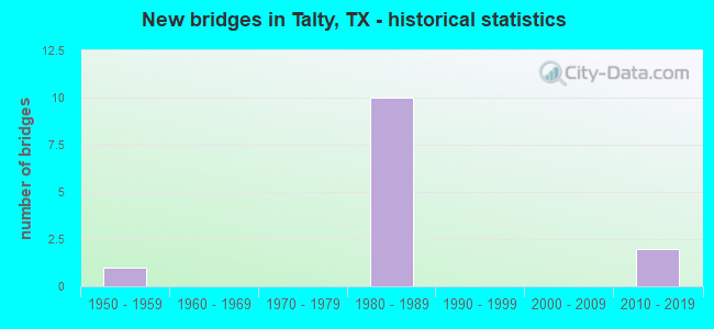
- New bridges - historical statistics
- 11950-1959
- 101980-1989
- 22010-2019


- Bridge Condition - Deck
- 10.0%Very good
- 50.0%Good
- 40.0%Satisfactory

- Bridge Condition - Superstructure
- 20.0%Very good
- 30.0%Good
- 50.0%Satisfactory

- Bridge Condition - Substructure
- 10.0%Very good
- 60.0%Good
- 30.0%Satisfactory

- Bridge Condition - Channel
- 11.1%Very good
- 44.4%Good
- 33.3%Satisfactory
- 11.1%Fair
Find on map >> Show street view
Structure Number: 181300009514355, Location: 3.10 MI E OF FM 741 (Lat: 32.695978, Lng: -96.400011), Route carried "on" structure: Interstate 20, Year Built: 1987, Status: Open, Structure Length: 7.92m (25.98ft), Average Daily Traffic: 17,038 (year 2019), Truck Traffic: 17%, Average Future Daily Traffic: 18,990 (year 2033), Design Load: HS 20, Features Intersected: FM 1641
Minimum Vertical Clearance: 30+ m (98+ ft), Kilometerpoint: 11.236, Lanes on structure: 2, Lanes under structure: 3, Owner: State Highway Agency, Approaching Roadway Width: 11.6m (38.1ft), Skew: 4 degrees, Material/Design: Prestressed concrete, Design/Construction: Stringer/Multi-beam, Number Of Spans In Main Unit: 3, Length of Maximum Span: 27.4m (89.9ft), Curb-To-Curb Width: 11.4m (37.4ft), Out-to-Out Width: 12.2m (40.0ft)
Condition: Deck: Satisfactory, Superstructure: Good, Substructure: Good, Operating Rating: 54.4 metric tons, Method Used To Determine Operating Rating: Assigned rating based on Load Factor Design (LFD) reported in metric tons, Inventory Rating: 32.7 metric tons, Method Used To Determine Inventory Rating: Assigned rating based on Load Factor Design (LFD) reported in metric tons, Structural Evaluation: Better than present minimum criteria, Deck Geometry: Somewhat better than minimum adequacy, Underclear: Equal to present minimum criteria, Approach Roadway Alignment: Equal to present desirable criteria, Designated Inspection Frequency: Every 24 months, Inspection Date: March 2020, Deck Structure Type: Concrete Cast-file-Place
Find on map >> Show street view
Structure Number: 181300009514356, Location: 3.10 MI E OF FM 741 (Lat: 32.696064, Lng: -96.400117), Route carried "on" structure: Interstate 20, Year Built: 1987, Status: Open, Structure Length: 7.92m (25.98ft), Average Daily Traffic: 14,353 (year 2019), Truck Traffic: 17%, Average Future Daily Traffic: 18,990 (year 2033), Design Load: HS 20, Features Intersected: FM 1641
Minimum Vertical Clearance: 30+ m (98+ ft), Kilometerpoint: 11.236, Lanes on structure: 2, Lanes under structure: 3, Owner: State Highway Agency, Approaching Roadway Width: 11.6m (38.1ft), Skew: 4 degrees, Material/Design: Prestressed concrete, Design/Construction: Stringer/Multi-beam, Number Of Spans In Main Unit: 3, Length of Maximum Span: 27.4m (89.9ft), Curb-To-Curb Width: 11.4m (37.4ft), Out-to-Out Width: 12.2m (40.0ft)
Condition: Deck: Satisfactory, Superstructure: Good, Substructure: Satisfactory, Operating Rating: 54.4 metric tons, Method Used To Determine Operating Rating: Assigned rating based on Load Factor Design (LFD) reported in metric tons, Inventory Rating: 32.7 metric tons, Method Used To Determine Inventory Rating: Assigned rating based on Load Factor Design (LFD) reported in metric tons, Structural Evaluation: Equal to present minimum criteria, Deck Geometry: Somewhat better than minimum adequacy, Underclear: Equal to present minimum criteria, Approach Roadway Alignment: Equal to present desirable criteria, Designated Inspection Frequency: Every 24 months, Inspection Date: March 2020, Deck Structure Type: Concrete Cast-file-Place
Find on map >> Show street view
Structure Number: 181300009514357, Location: 6.40 MI W OF SH 34 (Lat: 32.697500, Lng: -96.377036), Route carried "on" structure: Interstate 20, Year Built: 1987, Status: Open, Structure Length: 13.72m (45.01ft), Average Daily Traffic: 17,038 (year 2019), Truck Traffic: 19%, Average Future Daily Traffic: 17,840 (year 2033), Design Load: HS 20, Features Intersected: BIG BRUSHY CRK REL NO 1
Minimum Vertical Clearance: 30+ m (98+ ft), Kilometerpoint: 13.398, Lanes on structure: 2, Owner: State Highway Agency, Approaching Roadway Width: 11.6m (38.1ft), Material/Design: Prestressed concrete, Design/Construction: Stringer/Multi-beam, Number Of Spans In Main Unit: 6, Length of Maximum Span: 22.9m (75.1ft), Curb-To-Curb Width: 11.4m (37.4ft), Out-to-Out Width: 12.2m (40.0ft)
Condition: Deck: Good, Superstructure: Satisfactory, Substructure: Satisfactory, Channel: Good, Operating Rating: 54.4 metric tons, Method Used To Determine Operating Rating: Assigned rating based on Load Factor Design (LFD) reported in metric tons, Inventory Rating: 32.7 metric tons, Method Used To Determine Inventory Rating: Assigned rating based on Load Factor Design (LFD) reported in metric tons, Structural Evaluation: Equal to present minimum criteria, Deck Geometry: Somewhat better than minimum adequacy, Waterway Adequacy: Superior to present desirable criteria, Approach Roadway Alignment: Equal to present desirable criteria, Designated Inspection Frequency: Every 24 months, Inspection Date: March 2020, Deck Structure Type: Concrete Precast Panels
Find on map >> Show street view
Structure Number: 181300009514358, Location: 6.40 MI W OF SH 34 (Lat: 32.697606, Lng: -96.377050), Route carried "on" structure: Interstate 20, Year Built: 1987, Status: Open, Structure Length: 13.72m (45.01ft), Average Daily Traffic: 14,353 (year 2019), Truck Traffic: 19%, Average Future Daily Traffic: 17,840 (year 2033), Design Load: HS 20, Features Intersected: BIG BRUSHY CRK REL NO 1
Minimum Vertical Clearance: 30+ m (98+ ft), Kilometerpoint: 13.398, Lanes on structure: 2, Owner: State Highway Agency, Approaching Roadway Width: 11.6m (38.1ft), Material/Design: Prestressed concrete, Design/Construction: Stringer/Multi-beam, Number Of Spans In Main Unit: 6, Length of Maximum Span: 22.9m (75.1ft), Curb-To-Curb Width: 11.4m (37.4ft), Out-to-Out Width: 12.2m (40.0ft)
Condition: Deck: Satisfactory, Superstructure: Satisfactory, Substructure: Good, Channel: Satisfactory, Operating Rating: 54.4 metric tons, Method Used To Determine Operating Rating: Assigned rating based on Load Factor Design (LFD) reported in metric tons, Inventory Rating: 32.7 metric tons, Method Used To Determine Inventory Rating: Assigned rating based on Load Factor Design (LFD) reported in metric tons, Structural Evaluation: Equal to present minimum criteria, Deck Geometry: Somewhat better than minimum adequacy, Waterway Adequacy: Superior to present desirable criteria, Approach Roadway Alignment: Equal to present desirable criteria, Designated Inspection Frequency: Every 24 months, Inspection Date: March 2020, Deck Structure Type: Concrete Precast Panels
Find on map >> Show street view
Structure Number: 181300009514359, Location: 6.15 MI W OF SH 34 (Lat: 32.698242, Lng: -96.373042), Route carried "on" structure: Interstate 20, Year Built: 1987, Status: Open, Structure Length: 6.86m (22.51ft), Average Daily Traffic: 17,038 (year 2019), Truck Traffic: 19%, Average Future Daily Traffic: 17,840 (year 2033), Design Load: HS 20, Features Intersected: BIG BRUSHY CREEK
Minimum Vertical Clearance: 30+ m (98+ ft), Kilometerpoint: 13.810, Lanes on structure: 2, Owner: State Highway Agency, Approaching Roadway Width: 11.6m (38.1ft), Material/Design: Prestressed concrete, Design/Construction: Stringer/Multi-beam, Number Of Spans In Main Unit: 3, Length of Maximum Span: 22.9m (75.1ft), Curb-To-Curb Width: 11.4m (37.4ft), Out-to-Out Width: 12.2m (40.0ft)
Condition: Deck: Good, Superstructure: Satisfactory, Substructure: Satisfactory, Channel: Fair, Operating Rating: 54.4 metric tons, Method Used To Determine Operating Rating: Assigned rating based on Load Factor Design (LFD) reported in metric tons, Inventory Rating: 32.7 metric tons, Method Used To Determine Inventory Rating: Assigned rating based on Load Factor Design (LFD) reported in metric tons, Structural Evaluation: Equal to present minimum criteria, Deck Geometry: Somewhat better than minimum adequacy, Waterway Adequacy: Equal to present minimum criteria, Approach Roadway Alignment: Equal to present desirable criteria, Designated Inspection Frequency: Every 24 months, Inspection Date: March 2020, Deck Structure Type: Concrete Precast Panels
Find on map >> Show street view
Structure Number: 18130000951436, Location: 6.15 MI W OF SH 34 (Lat: 32.698361, Lng: -96.373069), Route carried "on" structure: Interstate 20, Year Built: 1987, Status: Open, Structure Length: 6.86m (22.51ft), Average Daily Traffic: 14,353 (year 2019), Truck Traffic: 19%, Average Future Daily Traffic: 17,840 (year 2033), Design Load: HS 20, Features Intersected: BIG BRUSHY CREEK
Minimum Vertical Clearance: 30+ m (98+ ft), Kilometerpoint: 13.810, Lanes on structure: 2, Owner: State Highway Agency, Approaching Roadway Width: 11.6m (38.1ft), Material/Design: Prestressed concrete, Design/Construction: Stringer/Multi-beam, Number Of Spans In Main Unit: 3, Length of Maximum Span: 22.9m (75.1ft), Curb-To-Curb Width: 11.4m (37.4ft), Out-to-Out Width: 12.2m (40.0ft)
Condition: Deck: Satisfactory, Superstructure: Satisfactory, Substructure: Good, Channel: Satisfactory, Operating Rating: 54.4 metric tons, Method Used To Determine Operating Rating: Assigned rating based on Load Factor Design (LFD) reported in metric tons, Inventory Rating: 32.7 metric tons, Method Used To Determine Inventory Rating: Assigned rating based on Load Factor Design (LFD) reported in metric tons, Structural Evaluation: Equal to present minimum criteria, Deck Geometry: Somewhat better than minimum adequacy, Waterway Adequacy: Equal to present minimum criteria, Approach Roadway Alignment: Equal to present desirable criteria, Designated Inspection Frequency: Every 24 months, Inspection Date: March 2020, Deck Structure Type: Concrete Precast Panels
Find on map >> Show street view
Structure Number: 181300009514361, Location: 6.05 MI W OF SH 34 (Lat: 32.698578, Lng: -96.371278), Route carried "on" structure: Interstate 20, Year Built: 1987, Status: Open, Structure Length: 9.14m (29.99ft), Average Daily Traffic: 17,038 (year 2019), Truck Traffic: 19%, Average Future Daily Traffic: 17,840 (year 2033), Design Load: HS 20, Features Intersected: BIG BRUSHY CRK REL NO 2
Minimum Vertical Clearance: 30+ m (98+ ft), Kilometerpoint: 13.971, Lanes on structure: 2, Owner: State Highway Agency, Approaching Roadway Width: 11.6m (38.1ft), Material/Design: Prestressed concrete, Design/Construction: Stringer/Multi-beam, Number Of Spans In Main Unit: 4, Length of Maximum Span: 22.9m (75.1ft), Curb-To-Curb Width: 11.4m (37.4ft), Out-to-Out Width: 12.2m (40.0ft)
Condition: Deck: Good, Superstructure: Satisfactory, Substructure: Good, Channel: Good, Operating Rating: 54.4 metric tons, Method Used To Determine Operating Rating: Assigned rating based on Load Factor Design (LFD) reported in metric tons, Inventory Rating: 32.7 metric tons, Method Used To Determine Inventory Rating: Assigned rating based on Load Factor Design (LFD) reported in metric tons, Structural Evaluation: Equal to present minimum criteria, Deck Geometry: Somewhat better than minimum adequacy, Waterway Adequacy: Superior to present desirable criteria, Approach Roadway Alignment: Equal to present desirable criteria, Designated Inspection Frequency: Every 24 months, Inspection Date: March 2020, Deck Structure Type: Concrete Precast Panels, Wearing Surface/Protective System: Wearing Surface: Bituminous
Find on map >> Show street view
Structure Number: 181300009514362, Location: 6.05 MI W OF SH 34 (Lat: 32.698694, Lng: -96.371314), Route carried "on" structure: Interstate 20, Year Built: 1987, Status: Open, Structure Length: 9.14m (29.99ft), Average Daily Traffic: 14,353 (year 2019), Truck Traffic: 19%, Average Future Daily Traffic: 17,840 (year 2033), Design Load: HS 20, Features Intersected: BIG BRUSHY CRK REL NO 2
Minimum Vertical Clearance: 30+ m (98+ ft), Kilometerpoint: 13.971, Lanes on structure: 2, Owner: State Highway Agency, Approaching Roadway Width: 11.6m (38.1ft), Material/Design: Prestressed concrete, Design/Construction: Stringer/Multi-beam, Number Of Spans In Main Unit: 4, Length of Maximum Span: 22.9m (75.1ft), Curb-To-Curb Width: 11.4m (37.4ft), Out-to-Out Width: 12.2m (40.0ft)
Condition: Deck: Good, Superstructure: Good, Substructure: Good, Channel: Satisfactory, Operating Rating: 54.4 metric tons, Method Used To Determine Operating Rating: Assigned rating based on Load Factor Design (LFD) reported in metric tons, Inventory Rating: 32.7 metric tons, Method Used To Determine Inventory Rating: Assigned rating based on Load Factor Design (LFD) reported in metric tons, Structural Evaluation: Better than present minimum criteria, Deck Geometry: Somewhat better than minimum adequacy, Waterway Adequacy: Superior to present desirable criteria, Approach Roadway Alignment: Equal to present desirable criteria, Designated Inspection Frequency: Every 24 months, Inspection Date: March 2020, Deck Structure Type: Concrete Precast Panels
Find on map >> Show street view
Structure Number: 181300075101025, Location: 3.60 MI SW OF IH 20 (Lat: 32.679689, Lng: -96.369197), Route carried "on" structure: State highway 148, Year Built: 1959, Year Reconstructed: 2012, Status: Open, Structure Length: 0.98m (3.22ft), Average Daily Traffic: 5,676 (year 2020), Truck Traffic: 14%, Average Future Daily Traffic: 5,340 (year 2033), Design Load: HS 20, Features Intersected: BIG BRUSHY CRK RELIEF #1
Minimum Vertical Clearance: 30+ m (98+ ft), Kilometerpoint: 9.263, Lanes on structure: 2, Owner: State Highway Agency, Approaching Roadway Width: 7.3m (24.0ft), Material/Design: Concrete, Design/Construction: Culvert, Number Of Spans In Main Unit: 3, Length of Maximum Span: 3.0m (9.8ft), Curb-To-Curb Width: 8.6m (28.2ft), Out-to-Out Width: 20.4m (66.9ft)
Condition: Channel: Good, Culverts: Satisfactory, Operating Rating: 39.9 metric tons, Method Used To Determine Operating Rating: Load Factor (LF), Inventory Rating: 23.6 metric tons, Method Used To Determine Inventory Rating: Load Factor (LF), Structural Evaluation: Somewhat better than minimum adequacy, Deck Geometry: High priority of replacement, Waterway Adequacy: Superior to present desirable criteria, Approach Roadway Alignment: Equal to present desirable criteria, Designated Inspection Frequency: Every 24 months, Inspection Date: April 2020, Deck Structure Type: Concrete Cast-file-Place, Wearing Surface/Protective System: Wearing Surface: Bituminous
Find on map >> Show street view
Structure Number: 181300075101382, Location: 3.8 MI SW of IH 20 (Lat: 32.679128, Lng: -96.372325), Route carried "on" structure: State highway 148, Year Built: 2012, Status: Open, Structure Length: 5.64m (18.50ft), Average Daily Traffic: 5,676 (year 2020), Truck Traffic: 14%, Average Future Daily Traffic: 5,340 (year 2033), Design Load: HL 93, Features Intersected: Big Brushy Creek
Minimum Vertical Clearance: 30+ m (98+ ft), Kilometerpoint: 9.539, Lanes on structure: 2, Owner: State Highway Agency, Approaching Roadway Width: 13.4m (44.0ft), Material/Design: Prestressed concrete, Design/Construction: Stringer/Multi-beam, Number Of Spans In Main Unit: 2, Number Of Approach Spans: 1, Length of Maximum Span: 22.9m (75.1ft), Curb-To-Curb Width: 13.4m (44.0ft), Out-to-Out Width: 14.0m (45.9ft)
Condition: Deck: Good, Superstructure: Very good, Substructure: Good, Channel: Good, Operating Rating: 54.4 metric tons, Method Used To Determine Operating Rating: Assigned ratings based on Load and Resistance Factor Design (LRFD) reported in metric tons, Inventory Rating: 32.7 metric tons, Method Used To Determine Inventory Rating: Assigned ratings based on Load and Resistance Factor Design (LRFD) reported in metric tons, Structural Evaluation: Better than present minimum criteria, Deck Geometry: Equal to present minimum criteria, Waterway Adequacy: Superior to present desirable criteria, Approach Roadway Alignment: Equal to present desirable criteria, Designated Inspection Frequency: Every 24 months, Inspection Date: April 2020, Deck Structure Type: Concrete Precast Panels
Find on map >> Show street view
Structure Number: 181300075101386, Location: 3.95 MI SW of IH 20 (Lat: 32.679083, Lng: -96.374947), Route carried "on" structure: State highway 148, Year Built: 2012, Status: Open, Structure Length: 4.57m (14.99ft), Average Daily Traffic: 5,676 (year 2020), Truck Traffic: 14%, Average Future Daily Traffic: 5,340 (year 2033), Design Load: HL 93, Features Intersected: Big Brushy Crk Relief #2
Minimum Vertical Clearance: 30+ m (98+ ft), Kilometerpoint: 9.785, Lanes on structure: 2, Owner: State Highway Agency, Approaching Roadway Width: 13.4m (44.0ft), Material/Design: Prestressed concrete, Design/Construction: Stringer/Multi-beam, Number Of Spans In Main Unit: 3, Length of Maximum Span: 15.2m (49.9ft), Curb-To-Curb Width: 13.4m (44.0ft), Out-to-Out Width: 14.0m (45.9ft)
Condition: Deck: Very good, Superstructure: Very good, Substructure: Very good, Channel: Very good, Operating Rating: 54.4 metric tons, Method Used To Determine Operating Rating: Assigned ratings based on Load and Resistance Factor Design (LRFD) reported in metric tons, Inventory Rating: 32.7 metric tons, Method Used To Determine Inventory Rating: Assigned ratings based on Load and Resistance Factor Design (LRFD) reported in metric tons, Structural Evaluation: Equal to present desirable criteria, Deck Geometry: Equal to present minimum criteria, Waterway Adequacy: Superior to present desirable criteria, Approach Roadway Alignment: Equal to present minimum criteria, Designated Inspection Frequency: Every 24 months, Inspection Date: April 2020, Deck Structure Type: Concrete Precast Panels
Find on map >> Show street view
Structure Number: 181300009514355, Location: 3.10 MI E OF FM 741 (Lat: 32.695978, Lng: -96.400011), Route carried "under" structure: State highway 1641, Year Built: 1987, Structure Length: 0. m, Average Daily Traffic: 4,440 (year 2013), Truck Traffic: 5%, Features Intersected: FM 1641, Facility Carried by Structure: IH 20 EB
Minimum Vertical Clearance: 6.25m (20.51ft), Kilometerpoint: 6.634, Lanes on structure: 2, Lanes under structure: 3, Material/Design: Prestressed concrete, Design/Construction: Stringer/Multi-beam, Length of Maximum Span: 27.4m (89.9ft)
Find on map >> Show street view
Structure Number: 181300009514356, Location: 3.10 MI E OF FM 741 (Lat: 32.696064, Lng: -96.400117), Route carried "under" structure: State highway 1641, Year Built: 1987, Structure Length: 0. m, Average Daily Traffic: 4,440 (year 2013), Truck Traffic: 5%, Features Intersected: FM 1641, Facility Carried by Structure: IH 20 WB
Minimum Vertical Clearance: 5.31m (17.42ft), Kilometerpoint: 6.590, Lanes on structure: 2, Lanes under structure: 3, Material/Design: Prestressed concrete, Design/Construction: Stringer/Multi-beam, Length of Maximum Span: 27.4m (89.9ft)