Bridge Statistics for Tarboro, North Carolina (NC)
Condition, Traffic, Stress, Structural Evaluation, Project Costs
- National Bridge Inventory (NBI) Statistics
- 36Number of bridges
- 594ft / 181mTotal length
- 219,980Total average daily traffic
- 25,852Total average daily truck traffic
- National Bridge Inventory (NBI) Registered Bridges for Tarboro
- No street view available for this location
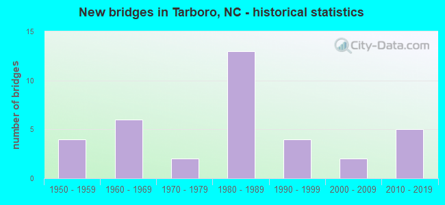
- New bridges - historical statistics
- 41950-1959
- 61960-1969
- 21970-1979
- 131980-1989
- 41990-1999
- 22000-2009
- 52010-2019
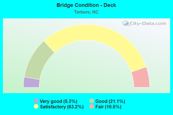
- Bridge Condition - Deck
- 5.3%Very good
- 21.1%Good
- 63.2%Satisfactory
- 10.5%Fair
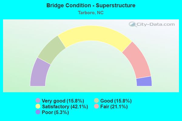
- Bridge Condition - Superstructure
- 15.8%Very good
- 15.8%Good
- 42.1%Satisfactory
- 21.1%Fair
- 5.3%Poor
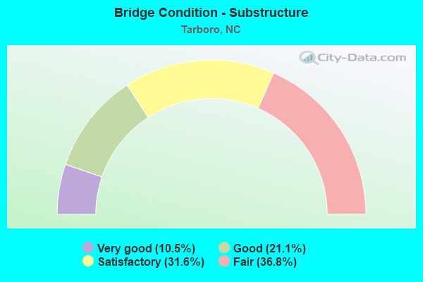
- Bridge Condition - Substructure
- 10.5%Very good
- 21.1%Good
- 31.6%Satisfactory
- 36.8%Fair
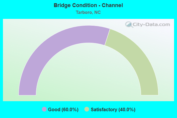
- Bridge Condition - Channel
- 60.0%Good
- 40.0%Satisfactory
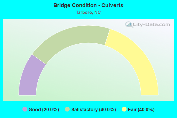
- Bridge Condition - Culverts
- 20.0%Good
- 40.0%Satisfactory
- 40.0%Fair
Find on map >> Show street view
Structure Number: 650024, Location: 0.3 MI. W. OF JCT.US258 (Lat: 35.893706, Lng: -77.532572), Route carried "on" structure: State highway 33, Year Built: 2010, Status: Open, Structure Length: 15.24m (50.00ft), Average Daily Traffic: 8,100 (year 2019), Truck Traffic: 12%, Average Future Daily Traffic: 16,200 (year 2040), Design Load: HS 25 or greater, Features Intersected: TAR RIVER
Minimum Vertical Clearance: 30+ m (98+ ft), Kilometerpoint: 0.000, Lanes on structure: 2, Lanes under structure: 1, Base Highway Network: Yes (Inventory Route: 3, Subroute: 33), Owner: State Highway Agency, Approaching Roadway Width: 10.3m (33.8ft), Material/Design: Steel continuous, Design/Construction: Stringer/Multi-beam, Number Of Spans In Main Unit: 3, Length of Maximum Span: 60.9m (199.8ft), Curb or Sidewalk Widths: Left: 1.6m (5.2ft), Right: 1.6m (5.2ft), Curb-To-Curb Width: 10.3m (33.8ft), Out-to-Out Width: 14.4m (47.2ft)
Condition: Deck: Satisfactory, Superstructure: Very good, Substructure: Good, Channel: Good, Operating Rating: 89.8 metric tons, Method Used To Determine Operating Rating: Load Factor (LF), Inventory Rating: 77.1 metric tons, Method Used To Determine Inventory Rating: Load Factor (LF), Structural Evaluation: Better than present minimum criteria, Deck Geometry: Meets minimum limits, Underclear: Superior to present desirable criteria, Waterway Adequacy: Better than present minimum criteria, Approach Roadway Alignment: Equal to present desirable criteria, Designated Inspection Frequency: Every 24 months, Underwater Inspection Frequency: Every 60 months, Inspection Date: Febuary 2021, Underwater Inspection Date: July 2021, Deck Structure Type: Concrete Cast-file-Place, Wearing Surface/Protective System: Wearing Surface: Monolithic Concrete, Deck Protection: Epoxy Coated Reinforcing
Find on map >> Show street view
Structure Number: 650039, Location: 1.1 MI. S. JCT. SR1602 (Lat: 35.825497, Lng: -77.562900), Route carried "on" structure: State highway 1601, Year Built: 2018, Status: Open, Structure Length: 0.82m (2.69ft), Average Daily Traffic: 2,000 (year 2019), Truck Traffic: 6%, Average Future Daily Traffic: 4,000 (year 2040), Design Load: HS 20+Mod, Features Intersected: JERRYS CREEK
Minimum Vertical Clearance: 30+ m (98+ ft), Kilometerpoint: 0.000, Lanes on structure: 2, Owner: State Highway Agency, Approaching Roadway Width: 7.9m (25.9ft), Skew: 1 degrees, Material/Design: Steel, Design/Construction: Culvert, Number Of Spans In Main Unit: 2, Length of Maximum Span: 3.3m (10.8ft)
Condition: Channel: Satisfactory, Culverts: Good, Operating Rating: 89.8 metric tons, Method Used To Determine Operating Rating: Load and Resistance Factor (LRFR), Inventory Rating: 76.2 metric tons, Method Used To Determine Inventory Rating: Load and Resistance Factor (LRFR), Structural Evaluation: Better than present minimum criteria, Waterway Adequacy: Better than present minimum criteria, Approach Roadway Alignment: Equal to present desirable criteria, Designated Inspection Frequency: Every 24 months, Inspection Date: October 2020
Find on map >> Show street view
Structure Number: 650049, Location: 1.1 MI. W. JCT US64BUS (Lat: 35.931925, Lng: -77.551564), Route carried "on" structure: State highway 33, Year Built: 1953, Status: Open, Structure Length: 5.73m (18.80ft), Average Daily Traffic: 4,000 (year 2019), Truck Traffic: 7%, Average Future Daily Traffic: 8,000 (year 2040), Design Load: HS 15, Features Intersected: TAR RIVER OVERFLOW
Minimum Vertical Clearance: 30+ m (98+ ft), Kilometerpoint: 0.000, Lanes on structure: 2, Owner: State Highway Agency, Approaching Roadway Width: 7.9m (25.9ft), Material/Design: Concrete, Design/Construction: Tee Beam, Number Of Spans In Main Unit: 5, Length of Maximum Span: 10.9m (35.8ft), Curb or Sidewalk Widths: Left: 0.4m (1.3ft), Right: 0.4m (1.3ft), Curb-To-Curb Width: 8.6m (28.2ft), Out-to-Out Width: 10.2m (33.5ft)
Condition: Deck: Fair, Superstructure: Fair, Substructure: Fair, Channel: Good, Operating Rating: 46.2 metric tons, Method Used To Determine Operating Rating: Load Factor (LF), Inventory Rating: 27.2 metric tons, Method Used To Determine Inventory Rating: Load Factor (LF), Structural Evaluation: Somewhat better than minimum adequacy, Deck Geometry: Meets minimum limits, Waterway Adequacy: Somewhat better than minimum adequacy, Approach Roadway Alignment: Equal to present desirable criteria, Designated Inspection Frequency: Every 24 months, Inspection Date: January 2021, Deck Structure Type: Concrete Cast-file-Place, Wearing Surface/Protective System: Wearing Surface: Bituminous
Find on map >> Show street view
Structure Number: 65008, Location: 0.7 MI.W.JCT.US64BUS (Lat: 35.928228, Lng: -77.549772), Route carried "on" structure: State highway 33, Year Built: 1953, Status: Open, Structure Length: 12.28m (40.29ft), Average Daily Traffic: 4,000 (year 2019), Truck Traffic: 6%, Average Future Daily Traffic: 8,000 (year 2040), Design Load: H 15, Features Intersected: TAR RIVER
Minimum Vertical Clearance: 30+ m (98+ ft), Kilometerpoint: 0.000, Lanes on structure: 2, Owner: State Highway Agency, Approaching Roadway Width: 8.5m (27.9ft), Material/Design: Concrete, Design/Construction: Tee Beam, Number Of Spans In Main Unit: 9, Length of Maximum Span: 15.5m (50.9ft), Curb or Sidewalk Widths: Left: 0.5m (1.6ft), Right: 0.5m (1.6ft), Curb-To-Curb Width: 8.5m (27.9ft), Out-to-Out Width: 10.2m (33.5ft)
Condition: Deck: Satisfactory, Superstructure: Fair, Substructure: Fair, Channel: Good, Operating Rating: 53.5 metric tons, Method Used To Determine Operating Rating: Load Factor (LF), Inventory Rating: 31.7 metric tons, Method Used To Determine Inventory Rating: Load Factor (LF), Structural Evaluation: Somewhat better than minimum adequacy, Deck Geometry: Meets minimum limits, Waterway Adequacy: Better than present minimum criteria, Approach Roadway Alignment: Equal to present desirable criteria, Designated Inspection Frequency: Every 24 months, Underwater Inspection Frequency: Every 60 months, Inspection Date: Febuary 2021, Underwater Inspection Date: April 2019, Deck Structure Type: Concrete Cast-file-Place, Wearing Surface/Protective System: Wearing Surface: Bituminous
Find on map >> Show street view
Structure Number: 650085, Location: 2.1 MI N OF NC122 (Lat: 35.954189, Lng: -77.499650), Route carried "on" structure: US 258, Year Built: 2007, Status: Open, Structure Length: 5.27m (17.29ft), Average Daily Traffic: 1,800 (year 2018), Truck Traffic: 8%, Average Future Daily Traffic: 3,600 (year 2040), Design Load: HS 20+Mod, Features Intersected: DEEP CREEK
Minimum Vertical Clearance: 30+ m (98+ ft), Kilometerpoint: 0.000, Lanes on structure: 2, Base Highway Network: Yes (Inventory Route: 2, Subroute: 58), Owner: State Highway Agency, Approaching Roadway Width: 11.8m (38.7ft), Material/Design: Prestressed concrete, Design/Construction: Slab, Number Of Spans In Main Unit: 3, Length of Maximum Span: 17.9m (58.7ft), Curb-To-Curb Width: 11.8m (38.7ft), Out-to-Out Width: 12.8m (42.0ft)
Condition: Deck: Good, Superstructure: Good, Substructure: Very good, Channel: Good, Operating Rating: 69.8 metric tons, Method Used To Determine Operating Rating: Load Factor (LF), Inventory Rating: 41.7 metric tons, Method Used To Determine Inventory Rating: Load Factor (LF), Structural Evaluation: Better than present minimum criteria, Deck Geometry: Equal to present minimum criteria, Waterway Adequacy: Better than present minimum criteria, Approach Roadway Alignment: Equal to present desirable criteria, Designated Inspection Frequency: Every 24 months, Underwater Inspection Frequency: Every 60 months, Inspection Date: December 2020, Underwater Inspection Date: March 2021, Deck Structure Type: Concrete Precast Panels, Wearing Surface/Protective System: Wearing Surface: Bituminous
Find on map >> Show street view
Structure Number: 650086, Location: 0.5 MI.W. OF JCT.SR1216 (Lat: 35.925219, Lng: -77.621833), Route carried "on" structure: Alternate US 64, Year Built: 2019, Status: Open, Structure Length: 2.80m (9.19ft), Average Daily Traffic: 4,400 (year 2018), Truck Traffic: 7%, Average Future Daily Traffic: 8,800 (year 2040), Design Load: HL 93, Features Intersected: PENDERS MILL RUN
Minimum Vertical Clearance: 30+ m (98+ ft), Kilometerpoint: 0.000, Lanes on structure: 2, Owner: State Highway Agency, Approaching Roadway Width: 10.0m (32.8ft), Material/Design: Prestressed concrete, Design/Construction: Box Beam or Girders - Multiple, Number Of Spans In Main Unit: 1, Length of Maximum Span: 27.1m (88.9ft), Curb-To-Curb Width: 10.1m (33.1ft), Out-to-Out Width: 10.9m (35.8ft)
Condition: Deck: Very good, Superstructure: Very good, Substructure: Very good, Channel: Good, Operating Rating: 69.8 metric tons, Method Used To Determine Operating Rating: Load and Resistance Factor (LRFR), Inventory Rating: 48.9 metric tons, Method Used To Determine Inventory Rating: Load and Resistance Factor (LRFR), Structural Evaluation: Equal to present desirable criteria, Deck Geometry: Meets minimum limits, Waterway Adequacy: Better than present minimum criteria, Approach Roadway Alignment: Equal to present desirable criteria, Designated Inspection Frequency: Every 24 months, Inspection Date: Febuary 2022, Deck Structure Type: Concrete Precast Panels, Wearing Surface/Protective System: Wearing Surface: Bituminous, Deck Protection: Epoxy Coated Reinforcing
Find on map >> Show street view
Structure Number: 650091, Location: 0.5 MI. E. JCT. SR1514 (Lat: 35.973114, Lng: -77.536508), Route carried "on" structure: State highway 1500, Year Built: 1985, Status: Open, Structure Length: 3.41m (11.19ft), Average Daily Traffic: 300 (year 2018), Truck Traffic: 6%, Average Future Daily Traffic: 600 (year 2040), Design Load: HS 20+Mod, Features Intersected: FISHING CREEK OVERFLOW
Minimum Vertical Clearance: 30+ m (98+ ft), Kilometerpoint: 0.000, Lanes on structure: 2, Owner: State Highway Agency, Approaching Roadway Width: 7.3m (24.0ft), Material/Design: Prestressed concrete, Design/Construction: Slab, Number Of Spans In Main Unit: 3, Number Of Approach Spans: 2, Length of Maximum Span: 11.5m (37.7ft), Curb-To-Curb Width: 7.3m (24.0ft), Out-to-Out Width: 8.2m (26.9ft)
Condition: Deck: Satisfactory, Superstructure: Satisfactory, Substructure: Satisfactory, Channel: Good, Operating Rating: 79.8 metric tons, Method Used To Determine Operating Rating: Load Factor (LF), Inventory Rating: 47.1 metric tons, Method Used To Determine Inventory Rating: Load Factor (LF), Structural Evaluation: Equal to present minimum criteria, Deck Geometry: Somewhat better than minimum adequacy, Waterway Adequacy: Better than present minimum criteria, Approach Roadway Alignment: Equal to present desirable criteria, Designated Inspection Frequency: Every 24 months, Inspection Date: Febuary 2021, Deck Structure Type: Concrete Precast Panels, Wearing Surface/Protective System: Wearing Surface: Bituminous
Find on map >> Show street view
Structure Number: 650094, Location: 2.5 MI.N. OF JCT.NC122 (Lat: 35.958692, Lng: -77.500031), Route carried "on" structure: US 258, Year Built: 1977, Status: Open, Structure Length: 0.67m (2.20ft), Average Daily Traffic: 1,800 (year 2017), Truck Traffic: 8%, Average Future Daily Traffic: 3,600 (year 2040), Design Load: HS 20+Mod, Features Intersected: BR. OF DEEP CREEK
Minimum Vertical Clearance: 30+ m (98+ ft), Kilometerpoint: 0.000, Lanes on structure: 2, Base Highway Network: Yes (Inventory Route: 2, Subroute: 58), Owner: State Highway Agency, Approaching Roadway Width: 10.6m (34.8ft), Skew: 2 degrees, Material/Design: Steel, Design/Construction: Culvert, Number Of Spans In Main Unit: 2, Length of Maximum Span: 2.7m (8.9ft)
Condition: Channel: Satisfactory, Culverts: Fair, Operating Rating: 89.8 metric tons, Method Used To Determine Operating Rating: Load and Resistance Factor (LRFR), Inventory Rating: 89.8 metric tons, Method Used To Determine Inventory Rating: Load and Resistance Factor (LRFR), Structural Evaluation: Somewhat better than minimum adequacy, Waterway Adequacy: Better than present minimum criteria, Approach Roadway Alignment: Equal to present desirable criteria, Designated Inspection Frequency: Every 24 months, Inspection Date: October 2020
Find on map >> Show street view
Structure Number: 650095, Location: 1.2 MI E OF US64BUS (Lat: 35.909369, Lng: -77.562722), Route carried "on" structure: Alternate US 64, Year Built: 1967, Status: Open, Structure Length: 6.00m (19.69ft), Average Daily Traffic: 7,900 (year 2018), Truck Traffic: 12%, Average Future Daily Traffic: 15,800 (year 2040), Design Load: HS 20+Mod, Features Intersected: SR1212 & SCL RR
Minimum Vertical Clearance: 30+ m (98+ ft), Kilometerpoint: 0.000, Lanes on structure: 2, Lanes under structure: 2, Base Highway Network: Yes (Inventory Route: 2, Subroute: 64), Owner: State Highway Agency, Approaching Roadway Width: 11.5m (37.7ft), Material/Design: Steel, Design/Construction: Stringer/Multi-beam, Number Of Spans In Main Unit: 4, Length of Maximum Span: 15.5m (50.9ft), Curb-To-Curb Width: 10.9m (35.8ft), Out-to-Out Width: 11.5m (37.7ft)
Condition: Deck: Satisfactory, Superstructure: Satisfactory, Substructure: Fair, Operating Rating: 51.7 metric tons, Method Used To Determine Operating Rating: Load Factor (LF), Inventory Rating: 30.8 metric tons, Method Used To Determine Inventory Rating: Load Factor (LF), Structural Evaluation: Somewhat better than minimum adequacy, Deck Geometry: Meets minimum limits, Underclear: Somewhat better than minimum adequacy, Approach Roadway Alignment: Equal to present desirable criteria, Designated Inspection Frequency: Every 24 months, Inspection Date: January 2021, Deck Structure Type: Concrete Cast-file-Place, Wearing Surface/Protective System: Wearing Surface: Bituminous
Find on map >> Show street view
Structure Number: 650101, Location: 0.3 MI. SE. OF JCT.SR1289 (Lat: 35.886725, Lng: -77.547475), Route carried "on" structure: Alternate US 64, Year Built: 1967, Status: Open, Structure Length: 6.43m (21.10ft), Average Daily Traffic: 16,000 (year 2015), Truck Traffic: 14%, Average Future Daily Traffic: 32,000 (year 2025), Design Load: HS 20+Mod, Features Intersected: US64
Minimum Vertical Clearance: 30+ m (98+ ft), Kilometerpoint: 147.829, Lanes on structure: 4, Lanes under structure: 5, Base Highway Network: Yes (Inventory Route: 2, Subroute: 64), Owner: State Highway Agency, Approaching Roadway Width: 17.3m (56.8ft), Skew: 1 degrees, Material/Design: Steel, Design/Construction: Stringer/Multi-beam, Number Of Spans In Main Unit: 4, Length of Maximum Span: 21.3m (69.9ft), Curb or Sidewalk Widths: Left: 0.4m (1.3ft), Right: 0.4m (1.3ft), Curb-To-Curb Width: 17.0m (55.8ft), Out-to-Out Width: 18.7m (61.4ft)
Condition: Deck: Satisfactory, Superstructure: Poor, Substructure: Fair, Operating Rating: 51.7 metric tons, Method Used To Determine Operating Rating: Load Factor (LF), Inventory Rating: 30.8 metric tons, Method Used To Determine Inventory Rating: Load Factor (LF), Structural Evaluation: Meets minimum limits, Deck Geometry: Somewhat better than minimum adequacy, Underclear: Meets minimum limits, Approach Roadway Alignment: Equal to present desirable criteria, Designated Inspection Frequency: Every 24 months, Inspection Date: November 2020, Deck Structure Type: Concrete Cast-file-Place, Wearing Surface/Protective System: Wearing Surface: Bituminous
Find on map >> Show street view
Structure Number: 650104, Location: 0.9 MI.W.US64 BUS (Lat: 35.887453, Lng: -77.538611), Route carried "on" structure: Bypass US 64, Year Built: 1967, Status: Open, Structure Length: 14.93m (48.98ft), Average Daily Traffic: 13,000 (year 2019), Truck Traffic: 12%, Average Future Daily Traffic: 26,000 (year 2040), Design Load: HS 20+Mod, Features Intersected: TAR RIVER
Minimum Vertical Clearance: 30+ m (98+ ft), Kilometerpoint: 0.000, Lanes on structure: 3, Base Highway Network: Yes (Inventory Route: 2, Subroute: 64), Owner: State Highway Agency, Approaching Roadway Width: 13.1m (43.0ft), Skew: 11 degrees, Material/Design: Steel, Design/Construction: Stringer/Multi-beam, Number Of Spans In Main Unit: 7, Length of Maximum Span: 21.0m (68.9ft), Curb-To-Curb Width: 13.8m (45.3ft), Out-to-Out Width: 14.6m (47.9ft)
Condition: Deck: Satisfactory, Superstructure: Satisfactory, Substructure: Fair, Channel: Satisfactory, Operating Rating: 75.2 metric tons, Method Used To Determine Operating Rating: Load Factor (LF), Inventory Rating: 45.3 metric tons, Method Used To Determine Inventory Rating: Load Factor (LF), Structural Evaluation: Somewhat better than minimum adequacy, Deck Geometry: Meets minimum limits, Waterway Adequacy: Better than present minimum criteria, Approach Roadway Alignment: Equal to present desirable criteria, Designated Inspection Frequency: Every 24 months, Underwater Inspection Frequency: Every 60 months, Inspection Date: Febuary 2021, Underwater Inspection Date: April 2018, Deck Structure Type: Concrete Cast-file-Place, Wearing Surface/Protective System: Wearing Surface: Bituminous, Deck Protection: Epoxy Coated Reinforcing
Find on map >> Show street view
Structure Number: 650106, Location: 0.4 MI W NC 42 (Lat: 35.821969, Lng: -77.455700), Route carried "on" structure: Alternate US 64, Year Built: 1954, Status: Open, Structure Length: 0.91m (2.99ft), Average Daily Traffic: 1,400 (year 2018), Truck Traffic: 7%, Average Future Daily Traffic: 2,800 (year 2040), Design Load: HS 20+Mod, Features Intersected: CONETOE CREEK
Minimum Vertical Clearance: 30+ m (98+ ft), Kilometerpoint: 0.000, Lanes on structure: 2, Owner: State Highway Agency, Approaching Roadway Width: 8.2m (26.9ft), Skew: 4 degrees, Material/Design: Concrete continuous, Design/Construction: Culvert, Number Of Spans In Main Unit: 2, Length of Maximum Span: 3.3m (10.8ft)
Condition: Channel: Satisfactory, Culverts: Satisfactory, Operating Rating: 41.7 metric tons, Method Used To Determine Operating Rating: Field evaluation and documented engineering judgment, Inventory Rating: 32.6 metric tons, Method Used To Determine Inventory Rating: Field evaluation and documented engineering judgment, Structural Evaluation: Equal to present minimum criteria, Waterway Adequacy: Better than present minimum criteria, Approach Roadway Alignment: Equal to present desirable criteria, Designated Inspection Frequency: Every 24 months, Inspection Date: October 2020
Find on map >> Show street view
Structure Number: 650107, Location: 0.7 MI W. OF JCT US64 (Lat: 35.933153, Lng: -77.611919), Route carried "on" structure: State highway 1336, Year Built: 1975, Status: Open, Structure Length: 1.85m (6.07ft), Average Daily Traffic: 880 (year 2017), Truck Traffic: 6%, Average Future Daily Traffic: 1,760 (year 2040), Design Load: HS 15, Features Intersected: PENDERS MILL RUN
Minimum Vertical Clearance: 30+ m (98+ ft), Kilometerpoint: 0.000, Lanes on structure: 2, Owner: State Highway Agency, Approaching Roadway Width: 7.9m (25.9ft), Material/Design: Prestressed concrete, Design/Construction: Slab, Number Of Spans In Main Unit: 2, Length of Maximum Span: 8.8m (28.9ft), Curb-To-Curb Width: 8.9m (29.2ft), Out-to-Out Width: 9.2m (30.2ft)
Condition: Deck: Satisfactory, Superstructure: Satisfactory, Substructure: Fair, Channel: Satisfactory, Operating Rating: 57.1 metric tons, Method Used To Determine Operating Rating: Load Factor (LF), Inventory Rating: 33.5 metric tons, Method Used To Determine Inventory Rating: Load Factor (LF), Structural Evaluation: Somewhat better than minimum adequacy, Deck Geometry: Somewhat better than minimum adequacy, Waterway Adequacy: Better than present minimum criteria, Approach Roadway Alignment: Equal to present desirable criteria, Designated Inspection Frequency: Every 24 months, Inspection Date: November 2020, Deck Structure Type: Concrete Precast Panels, Wearing Surface/Protective System: Wearing Surface: Bituminous
Find on map >> Show street view
Structure Number: 650141, Location: 0.7 MI. E. OF JCT. US64B (Lat: 35.898050, Lng: -77.540169), Route carried "on" structure: State highway 1350, Year Built: 1950, Status: Open, Structure Length: 0.64m (2.10ft), Average Daily Traffic: 7,100 (year 2015), Truck Traffic: 6%, Average Future Daily Traffic: 14,200 (year 2040), Design Load: HS 20, Features Intersected: HENDRICKS CREEK
Minimum Vertical Clearance: 30+ m (98+ ft), Kilometerpoint: 0.000, Lanes on structure: 3, Owner: State Highway Agency, Approaching Roadway Width: 13.4m (44.0ft), Material/Design: Concrete continuous, Design/Construction: Culvert, Number Of Spans In Main Unit: 2, Length of Maximum Span: 3.0m (9.8ft)
Condition: Channel: Satisfactory, Culverts: Fair, Operating Rating: 41.7 metric tons, Method Used To Determine Operating Rating: Field evaluation and documented engineering judgment, Inventory Rating: 32.6 metric tons, Method Used To Determine Inventory Rating: Field evaluation and documented engineering judgment, Structural Evaluation: Somewhat better than minimum adequacy, Waterway Adequacy: Better than present minimum criteria, Approach Roadway Alignment: Equal to present desirable criteria, Designated Inspection Frequency: Every 24 months, Inspection Date: November 2020
Find on map >> Show street view
Structure Number: 650142, Location: 0.3 MI.W.JCT.US64B (Lat: 35.895714, Lng: -77.538531), Route carried "on" structure: State highway 1289, Year Built: 2001, Status: Open, Structure Length: 0.97m (3.18ft), Average Daily Traffic: 3,900 (year 2019), Truck Traffic: 7%, Average Future Daily Traffic: 7,800 (year 2040), Design Load: HS 20+Mod, Features Intersected: HENDRICKS CREEK
Minimum Vertical Clearance: 30+ m (98+ ft), Kilometerpoint: 0.000, Lanes on structure: 2, Owner: State Highway Agency, Approaching Roadway Width: 10.9m (35.8ft), Skew: 1 degrees, Material/Design: Concrete continuous, Design/Construction: Culvert, Number Of Spans In Main Unit: 3, Length of Maximum Span: 3.0m (9.8ft)
Condition: Channel: Good, Culverts: Satisfactory, Operating Rating: 41.7 metric tons, Method Used To Determine Operating Rating: Field evaluation and documented engineering judgment, Inventory Rating: 32.6 metric tons, Method Used To Determine Inventory Rating: Field evaluation and documented engineering judgment, Structural Evaluation: Equal to present minimum criteria, Waterway Adequacy: Better than present minimum criteria, Approach Roadway Alignment: Equal to present desirable criteria, Designated Inspection Frequency: Every 24 months, Inspection Date: November 2020
Find on map >> Show street view
Structure Number: 650151, Location: 0.3 MI. S. OF SR1208 (Lat: 35.892347, Lng: -77.618128), Route carried "on" structure: State highway 1218, Year Built: 1986, Status: Open, Structure Length: 5.42m (17.78ft), Average Daily Traffic: 650 (year 2017), Truck Traffic: 6%, Average Future Daily Traffic: 1,300 (year 2040), Design Load: HS 20+Mod, Features Intersected: US64
Minimum Vertical Clearance: 30+ m (98+ ft), Kilometerpoint: 0.000, Lanes on structure: 2, Lanes under structure: 4, Owner: State Highway Agency, Approaching Roadway Width: 8.2m (26.9ft), Material/Design: Prestressed concrete, Design/Construction: Stringer/Multi-beam, Number Of Spans In Main Unit: 2, Length of Maximum Span: 26.5m (86.9ft), Curb-To-Curb Width: 8.5m (27.9ft), Out-to-Out Width: 9.3m (30.5ft)
Condition: Deck: Good, Superstructure: Fair, Substructure: Fair, Operating Rating: 89.8 metric tons, Method Used To Determine Operating Rating: Load Factor (LF), Inventory Rating: 37.1 metric tons, Method Used To Determine Inventory Rating: Load Factor (LF), Structural Evaluation: Somewhat better than minimum adequacy, Deck Geometry: Somewhat better than minimum adequacy, Underclear: Equal to present minimum criteria, Approach Roadway Alignment: Equal to present desirable criteria, Designated Inspection Frequency: Every 24 months, Inspection Date: November 2020, Deck Structure Type: Concrete Cast-file-Place, Wearing Surface/Protective System: Wearing Surface: Monolithic Concrete, Membrane: Built-up, Deck Protection: Epoxy Coated Reinforcing
Find on map >> Show street view
Structure Number: 650152, Location: 1.0 MI. N. OF SR1344 (Lat: 35.883000, Lng: -77.570344), Route carried "on" structure: State highway 111, Year Built: 1986, Status: Open, Structure Length: 7.19m (23.59ft), Average Daily Traffic: 4,400 (year 2018), Truck Traffic: 8%, Average Future Daily Traffic: 8,800 (year 2040), Design Load: HS 20+Mod, Features Intersected: US 64
Minimum Vertical Clearance: 30+ m (98+ ft), Kilometerpoint: 0.000, Lanes on structure: 2, Lanes under structure: 4, Base Highway Network: Yes, Owner: State Highway Agency, Approaching Roadway Width: 8.2m (26.9ft), Skew: 3 degrees, Material/Design: Prestressed concrete, Design/Construction: Stringer/Multi-beam, Number Of Spans In Main Unit: 4, Length of Maximum Span: 24.6m (80.7ft), Curb-To-Curb Width: 9.1m (29.9ft), Out-to-Out Width: 10.0m (32.8ft)
Condition: Deck: Satisfactory, Superstructure: Satisfactory, Substructure: Satisfactory, Operating Rating: 77.1 metric tons, Method Used To Determine Operating Rating: Load Factor (LF), Inventory Rating: 34.4 metric tons, Method Used To Determine Inventory Rating: Load Factor (LF), Structural Evaluation: Equal to present minimum criteria, Deck Geometry: Meets minimum limits, Underclear: Meets minimum limits, Approach Roadway Alignment: Equal to present desirable criteria, Designated Inspection Frequency: Every 24 months, Inspection Date: November 2020, Deck Structure Type: Concrete Cast-file-Place, Wearing Surface/Protective System: Wearing Surface: Monolithic Concrete, Membrane: Built-up, Deck Protection: Epoxy Coated Reinforcing
Find on map >> Show street view
Structure Number: 650153, Location: 2.9 MI.E.SR1225 (Lat: 35.899339, Lng: -77.637000), Route carried "on" structure: Bypass US 64, Year Built: 1986, Status: Open, Structure Length: 3.74m (12.27ft), Average Daily Traffic: 10,750 (year 2019), Truck Traffic: 14%, Average Future Daily Traffic: 21,500 (year 2040), Design Load: HS 20+Mod, Features Intersected: SR1208
Minimum Vertical Clearance: 30+ m (98+ ft), Kilometerpoint: 146.610, Lanes on structure: 2, Lanes under structure: 2, Base Highway Network: Yes (Inventory Route: 2, Subroute: 64), Owner: State Highway Agency, Approaching Roadway Width: 10.0m (32.8ft), Skew: 13 degrees, Material/Design: Prestressed concrete, Design/Construction: Stringer/Multi-beam, Number Of Spans In Main Unit: 3, Number Of Approach Spans: 2, Length of Maximum Span: 16.4m (53.8ft), Curb-To-Curb Width: 10.9m (35.8ft), Out-to-Out Width: 11.8m (38.7ft)
Condition: Deck: Satisfactory, Superstructure: Satisfactory, Substructure: Satisfactory, Operating Rating: 89.8 metric tons, Method Used To Determine Operating Rating: Load Factor (LF), Inventory Rating: 48.0 metric tons, Method Used To Determine Inventory Rating: Load Factor (LF), Structural Evaluation: Equal to present minimum criteria, Deck Geometry: Somewhat better than minimum adequacy, Underclear: Equal to present minimum criteria, Approach Roadway Alignment: Equal to present desirable criteria, Designated Inspection Frequency: Every 24 months, Inspection Date: January 2021, Deck Structure Type: Concrete Cast-file-Place, Wearing Surface/Protective System: Wearing Surface: Monolithic Concrete
Find on map >> Show street view
Structure Number: 650154, Location: 0.3 MI.W.OF US258 (Lat: 35.884744, Lng: -77.554458), Route carried "on" structure: US 64, Year Built: 1986, Status: Open, Structure Length: 7.55m (24.77ft), Average Daily Traffic: 8,500 (year 2019), Truck Traffic: 12%, Average Future Daily Traffic: 17,000 (year 2040), Design Load: HS 20+Mod, Features Intersected: C.&O.RR
Minimum Vertical Clearance: 30+ m (98+ ft), Kilometerpoint: 147.829, Lanes on structure: 2, Base Highway Network: Yes (Inventory Route: 2, Subroute: 64), Owner: State Highway Agency, Approaching Roadway Width: 10.6m (34.8ft), Skew: 16 degrees, Material/Design: Prestressed concrete, Design/Construction: Stringer/Multi-beam, Number Of Spans In Main Unit: 3, Length of Maximum Span: 26.2m (86.0ft), Curb-To-Curb Width: 10.9m (35.8ft), Out-to-Out Width: 11.8m (38.7ft)
Condition: Deck: Fair, Superstructure: Fair, Substructure: Satisfactory, Operating Rating: 86.1 metric tons, Method Used To Determine Operating Rating: Load Factor (LF), Inventory Rating: 35.3 metric tons, Method Used To Determine Inventory Rating: Load Factor (LF), Structural Evaluation: Somewhat better than minimum adequacy, Deck Geometry: Meets minimum limits, Underclear: Equal to present minimum criteria, Approach Roadway Alignment: Equal to present desirable criteria, Designated Inspection Frequency: Every 24 months, Inspection Date: November 2020, Deck Structure Type: Concrete Cast-file-Place, Wearing Surface/Protective System: Wearing Surface: Monolithic Concrete
Find on map >> Show street view
Structure Number: 650156, Location: 2.9 MI.E.SR1225 (Lat: 35.899292, Lng: -77.637281), Route carried "on" structure: US 64, Year Built: 1986, Status: Open, Structure Length: 3.68m (12.07ft), Average Daily Traffic: 10,750 (year 2019), Truck Traffic: 14%, Average Future Daily Traffic: 21,500 (year 2040), Design Load: HS 20+Mod, Features Intersected: SR1208
Minimum Vertical Clearance: 30+ m (98+ ft), Kilometerpoint: 0.000, Lanes on structure: 2, Lanes under structure: 2, Base Highway Network: Yes (Inventory Route: 2, Subroute: 64), Owner: State Highway Agency, Approaching Roadway Width: 11.5m (37.7ft), Skew: 13 degrees, Material/Design: Prestressed concrete, Design/Construction: Stringer/Multi-beam, Number Of Spans In Main Unit: 3, Length of Maximum Span: 17.0m (55.8ft), Curb-To-Curb Width: 11.6m (38.1ft), Out-to-Out Width: 12.4m (40.7ft)
Condition: Deck: Satisfactory, Superstructure: Satisfactory, Substructure: Satisfactory, Operating Rating: 81.6 metric tons, Method Used To Determine Operating Rating: Load Factor (LF), Inventory Rating: 47.1 metric tons, Method Used To Determine Inventory Rating: Load Factor (LF), Structural Evaluation: Equal to present minimum criteria, Deck Geometry: Better than present minimum criteria, Underclear: Somewhat better than minimum adequacy, Approach Roadway Alignment: Equal to present desirable criteria, Designated Inspection Frequency: Every 24 months, Inspection Date: Febuary 2021, Deck Structure Type: Concrete Cast-file-Place, Wearing Surface/Protective System: Wearing Surface: Monolithic Concrete
Find on map >> Show street view
Structure Number: 650157, Location: 0.3 MI.W. OF JCT.US258 (Lat: 35.885039, Lng: -77.554144), Route carried "on" structure: US 64, Year Built: 1986, Status: Open, Structure Length: 7.25m (23.79ft), Average Daily Traffic: 11,500 (year 2019), Truck Traffic: 12%, Average Future Daily Traffic: 23,000 (year 2040), Design Load: HS 20+Mod, Features Intersected: C.&O.RR
Minimum Vertical Clearance: 30+ m (98+ ft), Kilometerpoint: 0.000, Lanes on structure: 2, Base Highway Network: Yes (Inventory Route: 2, Subroute: 64), Owner: State Highway Agency, Approaching Roadway Width: 10.9m (35.8ft), Skew: 14 degrees, Material/Design: Prestressed concrete, Design/Construction: Stringer/Multi-beam, Number Of Spans In Main Unit: 3, Length of Maximum Span: 25.2m (82.7ft), Curb-To-Curb Width: 11.5m (37.7ft), Out-to-Out Width: 12.4m (40.7ft)
Condition: Deck: Satisfactory, Superstructure: Satisfactory, Substructure: Satisfactory, Operating Rating: 74.3 metric tons, Method Used To Determine Operating Rating: Load Factor (LF), Inventory Rating: 35.3 metric tons, Method Used To Determine Inventory Rating: Load Factor (LF), Structural Evaluation: Equal to present minimum criteria, Deck Geometry: Somewhat better than minimum adequacy, Underclear: Equal to present minimum criteria, Approach Roadway Alignment: Equal to present desirable criteria, Designated Inspection Frequency: Every 24 months, Inspection Date: November 2020, Deck Structure Type: Concrete Cast-file-Place, Wearing Surface/Protective System: Wearing Surface: Monolithic Concrete
Find on map >> Show street view
Structure Number: 650316, Location: 0.5 MI. S. OF SR1208 (Lat: 35.885878, Lng: -77.587708), Route carried "on" structure: State highway 122, Year Built: 1994, Status: Open, Structure Length: 5.91m (19.39ft), Average Daily Traffic: 4,300 (year 2019), Truck Traffic: 8%, Average Future Daily Traffic: 8,600 (year 2040), Design Load: HS 20+Mod, Features Intersected: US64
Minimum Vertical Clearance: 30+ m (98+ ft), Kilometerpoint: 147.525, Lanes on structure: 2, Lanes under structure: 4, Owner: State Highway Agency, Approaching Roadway Width: 13.4m (44.0ft), Skew: 2 degrees, Material/Design: Prestressed concrete continuous, Design/Construction: Stringer/Multi-beam, Number Of Spans In Main Unit: 4, Number Of Approach Spans: 2, Length of Maximum Span: 20.1m (65.9ft), Curb-To-Curb Width: 14.6m (47.9ft), Out-to-Out Width: 15.5m (50.9ft)
Condition: Deck: Good, Superstructure: Good, Substructure: Good, Operating Rating: 89.8 metric tons, Method Used To Determine Operating Rating: Load Factor (LF), Inventory Rating: 46.2 metric tons, Method Used To Determine Inventory Rating: Load Factor (LF), Structural Evaluation: Better than present minimum criteria, Deck Geometry: Superior to present desirable criteria, Underclear: Somewhat better than minimum adequacy, Approach Roadway Alignment: Equal to present desirable criteria, Designated Inspection Frequency: Every 24 months, Inspection Date: November 2020, Deck Structure Type: Concrete Cast-file-Place, Wearing Surface/Protective System: Wearing Surface: Monolithic Concrete, Membrane: Built-up, Deck Protection: Epoxy Coated Reinforcing
Find on map >> Show street view
Structure Number: 65032, Location: .9 MI.W. JCT. US64 BUS. (Lat: 35.887692, Lng: -77.538553), Route carried "on" structure: US 64, Year Built: 1997, Status: Open, Structure Length: 15.48m (50.79ft), Average Daily Traffic: 10,250 (year 2018), Truck Traffic: 12%, Average Future Daily Traffic: 20,500 (year 2040), Design Load: HS 20+Mod, Features Intersected: TAR RIVER
Minimum Vertical Clearance: 30+ m (98+ ft), Kilometerpoint: 148.134, Lanes on structure: 2, Base Highway Network: Yes (Inventory Route: 2, Subroute: 64), Owner: State Highway Agency, Approaching Roadway Width: 10.9m (35.8ft), Skew: 11 degrees, Material/Design: Prestressed concrete continuous, Design/Construction: Stringer/Multi-beam, Number Of Spans In Main Unit: 7, Length of Maximum Span: 21.9m (71.9ft), Curb-To-Curb Width: 15.2m (49.9ft), Out-to-Out Width: 16.1m (52.8ft)
Condition: Deck: Satisfactory, Superstructure: Good, Substructure: Good, Channel: Good, Operating Rating: 72.5 metric tons, Method Used To Determine Operating Rating: Load Factor (LF), Inventory Rating: 40.8 metric tons, Method Used To Determine Inventory Rating: Load Factor (LF), Structural Evaluation: Better than present minimum criteria, Deck Geometry: Superior to present desirable criteria, Waterway Adequacy: Better than present minimum criteria, Approach Roadway Alignment: Equal to present desirable criteria, Designated Inspection Frequency: Every 24 months, Underwater Inspection Frequency: Every 60 months, Inspection Date: Febuary 2021, Underwater Inspection Date: April 2018, Deck Structure Type: Concrete Cast-file-Place, Wearing Surface/Protective System: Wearing Surface: Monolithic Concrete, Deck Protection: Epoxy Coated Reinforcing
Find on map >> Show street view
Structure Number: 650345, Location: 0.5 MI.N.JCT.SR1518 (Lat: 35.926158, Lng: -77.506317), Route carried "on" structure: State highway 1537, Year Built: 2011, Status: Open, Structure Length: 47.00m (154.20ft), Average Daily Traffic: 1,500 (year 2018), Truck Traffic: 7%, Average Future Daily Traffic: 2,800 (year 2040), Design Load: HS 25 or greater, Features Intersected: TAR RIVER
Minimum Vertical Clearance: 30+ m (98+ ft), Kilometerpoint: 0.000, Lanes on structure: 2, Owner: State Highway Agency, Approaching Roadway Width: 10.6m (34.8ft), Material/Design: Prestressed concrete continuous, Design/Construction: Stringer/Multi-beam, Number Of Spans In Main Unit: 14, Number Of Approach Spans: 12, Length of Maximum Span: 32.9m (107.9ft), Curb-To-Curb Width: 10.7m (35.1ft), Out-to-Out Width: 11.7m (38.4ft)
Condition: Deck: Good, Superstructure: Very good, Substructure: Good, Channel: Good, Operating Rating: 89.8 metric tons, Method Used To Determine Operating Rating: Load Factor (LF), Inventory Rating: 45.3 metric tons, Method Used To Determine Inventory Rating: Load Factor (LF), Structural Evaluation: Better than present minimum criteria, Deck Geometry: Equal to present minimum criteria, Waterway Adequacy: Better than present minimum criteria, Approach Roadway Alignment: Equal to present desirable criteria, Designated Inspection Frequency: Every 24 months, Underwater Inspection Frequency: Every 60 months, Inspection Date: May 2021, Underwater Inspection Date: November 2021, Deck Structure Type: Concrete Cast-file-Place, Wearing Surface/Protective System: Wearing Surface: Monolithic Concrete, Deck Protection: Epoxy Coated Reinforcing
Find on map >> Show street view
Structure Number: 650024, Location: 0.3 MI. W. OF JCT.US258 (Lat: 35.893706, Lng: -77.532572), Route carried "under" structure: ServiceOther road , Year Built: 2010, Structure Length: 0. m, Average Daily Traffic: 100 (year 2017), Truck Traffic: 7%, Features Intersected: NC33, Facility Carried by Structure: RIVER DR.
Minimum Vertical Clearance: 5.58m (18.31ft), Kilometerpoint: 0.000, Lanes on structure: 2, Lanes under structure: 1, Material/Design: Steel continuous, Design/Construction: Stringer/Multi-beam, Length of Maximum Span: 60.9m (199.8ft)
Find on map >> Show street view
Structure Number: 650095, Location: 1.2 MI E OF US64BUS (Lat: 35.909369, Lng: -77.562722), Route carried "under" structure: State highway 1212, Year Built: 1967, Structure Length: 0. m, Average Daily Traffic: 1,600 (year 2015), Truck Traffic: 6%, Features Intersected: US64ALT
Minimum Vertical Clearance: 7.36m (24.15ft), Kilometerpoint: 0.000, Lanes on structure: 2, Lanes under structure: 2, Material/Design: Steel, Design/Construction: Stringer/Multi-beam, Length of Maximum Span: 15.5m (50.9ft)
Find on map >> Show street view
Structure Number: 650101, Location: 0.3 MI. SE. OF JCT.SR1289 (Lat: 35.886725, Lng: -77.547475), Route carried "under" structure: US 64, Year Built: 1967, Structure Length: 0. m, Average Daily Traffic: 10,500 (year 2015), Truck Traffic: 12%, Features Intersected: US64A,US258
Minimum Vertical Clearance: 4.74m (15.55ft), Kilometerpoint: 0.000, Lanes on structure: 4, Lanes under structure: 2, Material/Design: Steel, Design/Construction: Stringer/Multi-beam, Length of Maximum Span: 21.3m (69.9ft)
Find on map >> Show street view
Structure Number: 650101, Location: 0.3 MI. SE. OF JCT.SR1289 (Lat: 35.886725, Lng: -77.547475), Route carried "under" structure: US 64, Year Built: 1967, Structure Length: 0. m, Average Daily Traffic: 10,500 (year 2015), Truck Traffic: 12%, Features Intersected: US64A,US258
Minimum Vertical Clearance: 4.69m (15.39ft), Kilometerpoint: 0.000, Lanes on structure: 4, Lanes under structure: 3, Material/Design: Steel, Design/Construction: Stringer/Multi-beam, Length of Maximum Span: 21.3m (69.9ft)
Find on map >> Show street view
Structure Number: 650151, Location: 0.3 MI. S. OF SR1208 (Lat: 35.892347, Lng: -77.618128), Route carried "under" structure: US 64, Year Built: 1986, Structure Length: 0. m, Average Daily Traffic: 10,750 (year 2019), Truck Traffic: 14%, Features Intersected: SR1218
Minimum Vertical Clearance: 5.05m (16.57ft), Kilometerpoint: 146.915, Lanes on structure: 2, Lanes under structure: 2, Material/Design: Prestressed concrete, Design/Construction: Stringer/Multi-beam, Length of Maximum Span: 26.5m (86.9ft)
Find on map >> Show street view
Structure Number: 650151, Location: 0.3 MI. S. OF SR1208 (Lat: 35.892347, Lng: -77.618128), Route carried "under" structure: US 64, Year Built: 1986, Structure Length: 0. m, Average Daily Traffic: 10,750 (year 2019), Truck Traffic: 14%, Features Intersected: SR1218
Minimum Vertical Clearance: 5.10m (16.73ft), Kilometerpoint: 146.915, Lanes on structure: 2, Lanes under structure: 2, Material/Design: Prestressed concrete, Design/Construction: Stringer/Multi-beam, Length of Maximum Span: 26.5m (86.9ft)
Find on map >> Show street view
Structure Number: 650152, Location: 1.0 MI. N. OF SR1344 (Lat: 35.883000, Lng: -77.570344), Route carried "under" structure: US 64, Year Built: 1986, Structure Length: 0. m, Average Daily Traffic: 8,500 (year 2018), Truck Traffic: 14%, Features Intersected: NC111
Minimum Vertical Clearance: 5.53m (18.14ft), Kilometerpoint: 147.829, Lanes on structure: 2, Lanes under structure: 2, Material/Design: Prestressed concrete, Design/Construction: Stringer/Multi-beam, Length of Maximum Span: 24.6m (80.7ft)
Find on map >> Show street view
Structure Number: 650152, Location: 1.0 MI. N. OF SR1344 (Lat: 35.883000, Lng: -77.570344), Route carried "under" structure: US 64, Year Built: 1986, Structure Length: 0. m, Average Daily Traffic: 8,500 (year 2018), Truck Traffic: 14%, Features Intersected: NC111
Minimum Vertical Clearance: 5.25m (17.22ft), Kilometerpoint: 147.829, Lanes on structure: 2, Lanes under structure: 2, Material/Design: Prestressed concrete, Design/Construction: Stringer/Multi-beam, Length of Maximum Span: 24.6m (80.7ft)
Find on map >> Show street view
Structure Number: 650153, Location: 2.9 MI.E.SR1225 (Lat: 35.899339, Lng: -77.637000), Route carried "under" structure: State highway 1208, Year Built: 1986, Structure Length: 0. m, Average Daily Traffic: 1,300 (year 2019), Truck Traffic: 6%, Features Intersected: US64 BYP E
Minimum Vertical Clearance: 5.43m (17.81ft), Kilometerpoint: 0.000, Lanes on structure: 2, Lanes under structure: 2, Material/Design: Prestressed concrete, Design/Construction: Stringer/Multi-beam, Length of Maximum Span: 16.4m (53.8ft)
Find on map >> Show street view
Structure Number: 650156, Location: 2.9 MI.E.SR1225 (Lat: 35.899292, Lng: -77.637281), Route carried "under" structure: State highway 1208, Year Built: 1986, Structure Length: 0. m, Average Daily Traffic: 1,300 (year 2019), Truck Traffic: 6%, Features Intersected: US64W
Minimum Vertical Clearance: 4.62m (15.16ft), Kilometerpoint: 0.000, Lanes on structure: 2, Lanes under structure: 2, Material/Design: Prestressed concrete, Design/Construction: Stringer/Multi-beam, Length of Maximum Span: 17.0m (55.8ft)
Find on map >> Show street view
Structure Number: 650316, Location: 0.5 MI. S. OF SR1208 (Lat: 35.885878, Lng: -77.587708), Route carried "under" structure: US 64, Year Built: 1994, Structure Length: 0. m, Average Daily Traffic: 8,500 (year 2015), Truck Traffic: 14%, Features Intersected: NC122
Minimum Vertical Clearance: 5.43m (17.81ft), Kilometerpoint: 147.525, Lanes on structure: 2, Lanes under structure: 2, Material/Design: Prestressed concrete continuous, Design/Construction: Stringer/Multi-beam, Length of Maximum Span: 20.1m (65.9ft)
Find on map >> Show street view
Structure Number: 650316, Location: 0.5 MI. S. OF SR1208 (Lat: 35.885878, Lng: -77.587708), Route carried "under" structure: US 64, Year Built: 1994, Structure Length: 0. m, Average Daily Traffic: 8,500 (year 2015), Truck Traffic: 14%, Features Intersected: NC122
Minimum Vertical Clearance: 5.20m (17.06ft), Kilometerpoint: 147.525, Lanes on structure: 2, Lanes under structure: 2, Material/Design: Prestressed concrete continuous, Design/Construction: Stringer/Multi-beam, Length of Maximum Span: 20.1m (65.9ft)