Bridge Statistics for Tarrytown, New York (NY)
Condition, Traffic, Stress, Structural Evaluation, Project Costs
- National Bridge Inventory (NBI) Statistics
- 10Number of bridges
- 154ft / 47.0mTotal length
- $54,882,000Total costs
- 306,236Total average daily traffic
- 30,489Total average daily truck traffic
- National Bridge Inventory (NBI) Registered Bridges for Tarrytown
- No street view available for this location
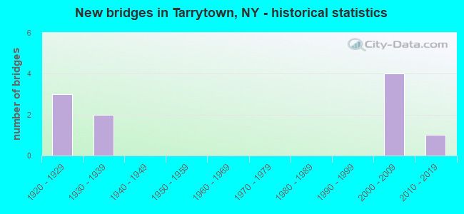
- New bridges - historical statistics
- 31920-1929
- 21930-1939
- 42000-2009
- 12010-2019
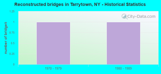
- Reconstructed bridges - Historical Statistics
- 11970-1979
- 11980-1989
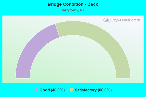
- Bridge Condition - Deck
- 40.0%Good
- 60.0%Satisfactory
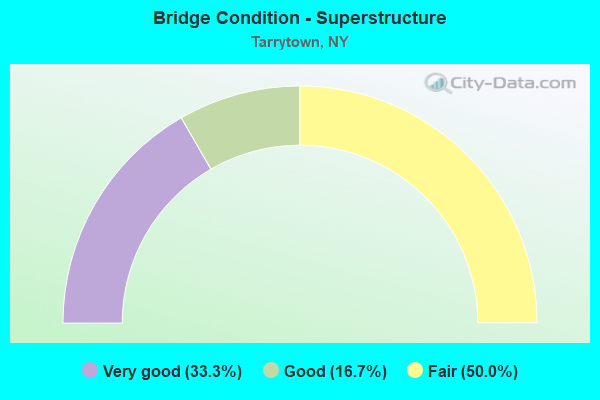
- Bridge Condition - Superstructure
- 33.3%Very good
- 16.7%Good
- 50.0%Fair
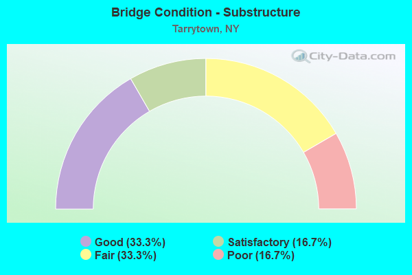
- Bridge Condition - Substructure
- 33.3%Good
- 16.7%Satisfactory
- 33.3%Fair
- 16.7%Poor
Find on map >> Show street view
Structure Number: 1004939, Location: JCT RTS 9 + I-87 (Lat: 41.062825, Lng: -73.862378), Route carried "on" structure: US 9, Year Built: 2003, Status: Open, Structure Length: 7.62m (25.00ft), Average Daily Traffic: 11,319 (year 2020), Truck Traffic: 6%, Average Future Daily Traffic: 11,372 (year 2040), Design Load: HS 20, Features Intersected: I-87 SB, RTE I87
Minimum Vertical Clearance: 30+ m (98+ ft), Kilometerpoint: 17.892, Lanes on structure: 5, Lanes under structure: 9, Base Highway Network: Yes, Owner: State Highway Agency, Maintenance Responsibility: State Toll Authority, Approaching Roadway Width: 20.7m (67.9ft), Skew: 24 degrees, Material/Design: Steel continuous, Design/Construction: Stringer/Multi-beam, Number Of Spans In Main Unit: 2, Length of Maximum Span: 36.9m (121.1ft), Curb or Sidewalk Widths: Left: 1.5m (4.9ft), Right: 1.5m (4.9ft), Curb-To-Curb Width: 20.7m (67.9ft), Out-to-Out Width: 24.7m (81.0ft)
Condition: Deck: Good, Superstructure: Very good, Substructure: Satisfactory, Operating Rating: 74.7 metric tons, Method Used To Determine Operating Rating: Load Factor (LF), Inventory Rating: 44.9 metric tons, Method Used To Determine Inventory Rating: Load Factor (LF), Structural Evaluation: Equal to present minimum criteria, Deck Geometry: Somewhat better than minimum adequacy, Underclear: Meets minimum limits, Approach Roadway Alignment: Equal to present desirable criteria, Length Of Structure Improvement: 7.62m (25.00ft), Designated Inspection Frequency: Every 24 months, Inspection Date: October 2021, Bridge Improvement Cost: $9,227,000, Roadway Improvement Cost: $5,403,000, Total Project Cost: $14,631,000 ( Estimate for 2021), Deck Structure Type: Concrete Cast-file-Place, Wearing Surface/Protective System: Wearing Surface: Bituminous, Membrane: Other, Deck Protection: Galvanized Reinforcing
Find on map >> Show street view
Structure Number: 22632, Location: N END VIL OF TARRYTOWN (Lat: 41.078861, Lng: -73.865281), Route carried "on" structure: Other road , Year Built: 1925, Year Reconstructed: 1992, Status: Open, Structure Length: 15.51m (50.89ft), Average Daily Traffic: 3,208 (year 1997), Truck Traffic: 3%, Average Future Daily Traffic: 4,491 (year 2017), Design Load: HS 20, Features Intersected: OTHER, Facility Carried by Structure: MAIN & RIVER STS
Minimum Vertical Clearance: 30+ m (98+ ft), Kilometerpoint: 0.000, Lanes on structure: 2, Owner: Town or Township Highway Agency, Approaching Roadway Width: 7.3m (24.0ft), Material/Design: Steel, Design/Construction: Stringer/Multi-beam, Number Of Spans In Main Unit: 16, Length of Maximum Span: 10.9m (35.8ft), Curb or Sidewalk Widths: Left: 0.0m, Right: 1.1m (3.6ft), Curb-To-Curb Width: 7.3m (24.0ft), Out-to-Out Width: 9.1m (29.9ft)
Condition: Deck: Satisfactory, Superstructure: Fair, Substructure: Fair, Operating Rating: 30.8 metric tons, Method Used To Determine Operating Rating: Load Factor (LF), Inventory Rating: 25.4 metric tons, Method Used To Determine Inventory Rating: Load Factor (LF), Structural Evaluation: Somewhat better than minimum adequacy, Deck Geometry: High priority of replacement, Approach Roadway Alignment: Equal to present desirable criteria, Length Of Structure Improvement: 15.51m (50.89ft), Designated Inspection Frequency: Every 24 months, Inspection Date: October 2021, Bridge Improvement Cost: $5,273,000, Roadway Improvement Cost: $3,088,000, Total Project Cost: $8,360,000 ( Estimate for 2021), Deck Structure Type: Concrete Cast-file-Place, Wearing Surface/Protective System: Wearing Surface: Integral Concrete, Deck Protection: Epoxy Coated Reinforcing
Find on map >> Show street view
Structure Number: 226320A, Location: N.END VIL OF TARRYTOWN (Lat: 41.078783, Lng: -73.864933), Route carried "on" structure: Other road , Year Built: 1925, Year Reconstructed: 1978, Status: Open, Structure Length: 2.13m (6.99ft), Truck Traffic: 3%, Design Load: HS 20, Features Intersected: MNRR HU LINE, Facility Carried by Structure: MAIN & WILDEY STS
Minimum Vertical Clearance: 30+ m (98+ ft), Kilometerpoint: 0.000, Lanes on structure: 2, Owner: Town or Township Highway Agency, Approaching Roadway Width: 14.6m (47.9ft), Material/Design: Steel, Design/Construction: Girder and Floorbeam System, Number Of Spans In Main Unit: 1, Length of Maximum Span: 20.7m (67.9ft), Curb or Sidewalk Widths: Left: 1.4m (4.6ft), Right: 1.4m (4.6ft), Curb-To-Curb Width: 13.3m (43.6ft), Out-to-Out Width: 14.5m (47.6ft)
Condition: Deck: Satisfactory, Superstructure: Fair, Substructure: Fair, Operating Rating: 42.6 metric tons, Method Used To Determine Operating Rating: Load Factor (LF), Inventory Rating: 25.4 metric tons, Method Used To Determine Inventory Rating: Load Factor (LF), Structural Evaluation: Somewhat better than minimum adequacy, Deck Geometry: Superior to present desirable criteria, Underclear: High priority of corrective action, Approach Roadway Alignment: Somewhat better than minimum adequacy, Length Of Structure Improvement: 2.13m (6.99ft), Designated Inspection Frequency: Every 24 months, Critical Feature Inspection Frequency: Every 24 months, Inspection Date: September 2021, Critical Feature Inspection Date: September 2021, Bridge Improvement Cost: $1,060,000, Roadway Improvement Cost: $621,000, Total Project Cost: $1,681,000 ( Estimate for 2021), Deck Structure Type: Concrete Cast-file-Place, Wearing Surface/Protective System: Wearing Surface: Integral Concrete, Deck Protection: Epoxy Coated Reinforcing
Find on map >> Show street view
Structure Number: 226321, Location: N END VIL OF TARRYTOWN (Lat: 41.078928, Lng: -73.864778), Route carried "on" structure: Other road , Year Built: 1925, Status: Open, Structure Length: 17.83m (58.50ft), Truck Traffic: 3%, Design Load: HS 20, Features Intersected: Parking Area, Facility Carried by Structure: MAIN & WILDEY STS
Minimum Vertical Clearance: 30+ m (98+ ft), Kilometerpoint: 0.000, Lanes on structure: 2, Owner: Town or Township Highway Agency, Approaching Roadway Width: 9.1m (29.9ft), Material/Design: Steel, Design/Construction: Stringer/Multi-beam, Number Of Spans In Main Unit: 20, Length of Maximum Span: 9.7m (31.8ft), Curb or Sidewalk Widths: Left: 1.4m (4.6ft), Right: 0.0m, Curb-To-Curb Width: 9.1m (29.9ft), Out-to-Out Width: 11.2m (36.7ft)
Condition: Deck: Satisfactory, Superstructure: Fair, Substructure: Poor, Operating Rating: 24.5 metric tons, Method Used To Determine Operating Rating: Load Factor (LF), Inventory Rating: 15.4 metric tons, Method Used To Determine Inventory Rating: Load Factor (LF), Structural Evaluation: Meets minimum limits, Deck Geometry: Better than present minimum criteria, Approach Roadway Alignment: Equal to present desirable criteria, Length Of Structure Improvement: 17.83m (58.50ft), Designated Inspection Frequency: Every 24 months, Critical Feature Inspection Frequency: Every 12 months, Inspection Date: June 2021, Critical Feature Inspection Date: June 2021, Bridge Improvement Cost: $7,425,000, Roadway Improvement Cost: $4,348,000, Total Project Cost: $11,773,000 ( Estimate for 2021), Deck Structure Type: Concrete Cast-file-Place, Wearing Surface/Protective System: Wearing Surface: Integral Concrete, Deck Protection: Epoxy Coated Reinforcing
Find on map >> Show street view
Structure Number: 5513939, Location: 0.5MI E JCT RTS I87&9 (Lat: 41.060750, Lng: -73.853161), Route carried "on" structure: Interstate 87, Year Built: 2004, Status: Open, Structure Length: 3.02m (9.91ft), Average Daily Traffic: 109,961 (year 2019), Truck Traffic: 10%, Average Future Daily Traffic: 186,207 (year 2040), Design Load: HS 25 or greater, Features Intersected: MEADOW STREET
Minimum Vertical Clearance: 30+ m (98+ ft), Kilometerpoint: 19.871, Lanes on structure: 8, Lanes under structure: 2, Base Highway Network: Yes, Toll: On Interstate toll segment, Owner: State Toll Authority, Approaching Roadway Width: 42.7m (140.1ft), Skew: 20 degrees, Material/Design: Steel, Design/Construction: Stringer/Multi-beam, Number Of Spans In Main Unit: 1, Length of Maximum Span: 29.0m (95.1ft), Curb-To-Curb Width: 42.8m (140.4ft), Out-to-Out Width: 45.2m (148.3ft)
Condition: Deck: Good, Superstructure: Good, Substructure: Good, Operating Rating: 77.0 metric tons, Method Used To Determine Operating Rating: Load Factor (LF), Inventory Rating: 46.1 metric tons, Method Used To Determine Inventory Rating: Load Factor (LF), Structural Evaluation: Better than present minimum criteria, Deck Geometry: Superior to present desirable criteria, Underclear: Somewhat better than minimum adequacy, Approach Roadway Alignment: Equal to present desirable criteria, Length Of Structure Improvement: 3.01m (9.88ft), Designated Inspection Frequency: Every 24 months, Inspection Date: July 2021, Bridge Improvement Cost: $8,181,000, Roadway Improvement Cost: $4,791,000, Total Project Cost: $12,972,000 ( Estimate for 2021), Deck Structure Type: Concrete Cast-file-Place, Wearing Surface/Protective System: Wearing Surface: Epoxy Overlay, Deck Protection: Galvanized Reinforcing
Find on map >> Show street view
Structure Number: 552507, Location: MC Bridge East Approach (Lat: 41.066739, Lng: -73.865931), Route carried "on" structure: Interstate 87, Year Built: 2017, Status: Open, Structure Length: 0.88m (2.89ft), Average Daily Traffic: 124,788 (year 2014), Truck Traffic: 15%, Average Future Daily Traffic: 211,315 (year 2040), Design Load: HL 93, Features Intersected: Fischer Drive Maintenanc
Minimum Vertical Clearance: 32.69m (107.25ft), Kilometerpoint: 21.174, Lanes on structure: 4, Lanes under structure: 2, Toll: On toll road, Owner: State Toll Authority, Approaching Roadway Width: 26.5m (86.9ft), Material/Design: Concrete, Design/Construction: Frame, Number Of Spans In Main Unit: 1, Length of Maximum Span: 8.2m (26.9ft), Curb-To-Curb Width: 26.5m (86.9ft), Out-to-Out Width: 58.2m (190.9ft)
Condition: Superstructure: Very good, Substructure: Good, Operating Rating: 78.4 metric tons, Method Used To Determine Operating Rating: Field evaluation and documented engineering judgment, Inventory Rating: 40.8 metric tons, Method Used To Determine Inventory Rating: Field evaluation and documented engineering judgment, Structural Evaluation: Better than present minimum criteria, Deck Geometry: Superior to present desirable criteria, Underclear: High priority of corrective action, Approach Roadway Alignment: Equal to present desirable criteria, Length Of Structure Improvement: 0.88m (2.89ft), Designated Inspection Frequency: Every 24 months, Inspection Date: September 2021, Bridge Improvement Cost: $3,447,000, Roadway Improvement Cost: $2,018,000, Total Project Cost: $5,465,000 ( Estimate for 2021), Deck Structure Type: Concrete Cast-file-Place, Wearing Surface/Protective System: Deck Protection: Galvanized Reinforcing
Find on map >> Show street view
Structure Number: 1004939, Location: JCT RTS 9 + I-87 (Lat: 41.062825, Lng: -73.862378), Route carried "under" structure: Interstate 87, Year Built: 2003, Structure Length: 0. m, Average Daily Traffic: 52,400 (year 1975), Features Intersected: I-87 SB, RTE I87, Facility Carried by Structure: RTE 9
Minimum Vertical Clearance: 6.15m (20.18ft), Kilometerpoint: 20.676, Lanes on structure: 5, Lanes under structure: 4, Toll: On Interstate toll segment, Material/Design: Steel continuous, Design/Construction: Stringer/Multi-beam, Length of Maximum Span: 36.9m (121.1ft)
Find on map >> Show street view
Structure Number: 5513939, Location: 0.5MI E JCT RTS I87&9 (Lat: 41.060750, Lng: -73.853161), Route carried "under" structure: Other road , Year Built: 2004, Structure Length: 0. m, Features Intersected: MEADOW STREET, Facility Carried by Structure: RTE I87
Minimum Vertical Clearance: 4.42m (14.50ft), Kilometerpoint: 0.000, Lanes on structure: 8, Lanes under structure: 2, Material/Design: Steel, Design/Construction: Stringer/Multi-beam, Length of Maximum Span: 29.0m (95.1ft)
Find on map >> Show street view
Structure Number: 750076, Location: 2.5 MI S JCT SMRP & TSP (Lat: 41.082125, Lng: -73.827667), Route carried "under" structure: City street 987D, Year Built: 1935, Structure Length: 0. m, Average Daily Traffic: 4,560 (year 2021), Features Intersected: 987DX SB, RTE 987D, Facility Carried by Structure: BIKE PATH
Minimum Vertical Clearance: 7.37m (24.18ft), Kilometerpoint: 21.400, Lanes under structure: 3, Material/Design: Steel, Design/Construction: Girder and Floorbeam System, Length of Maximum Span: 48.4m (158.8ft)
Find on map >> Show street view
Structure Number: 750076, Location: 2.5 MI S JCT SMRP & TSP (Lat: 41.082125, Lng: -73.827667), Route carried "under" structure: City street , Year Built: 1935, Structure Length: 0. m, Features Intersected: 987DX SB, RTE 987D, Facility Carried by Structure: BIKE PATH
Minimum Vertical Clearance: 5.59m (18.34ft), Kilometerpoint: 21.400, Lanes under structure: 2, Material/Design: Steel, Design/Construction: Girder and Floorbeam System, Length of Maximum Span: 48.4m (158.8ft)