Bridge Statistics for Taylor, Pennsylvania (PA)
Condition, Traffic, Stress, Structural Evaluation, Project Costs
- National Bridge Inventory (NBI) Statistics
- 12Number of bridges
- 135ft / 40.5mTotal length
- $3,592,000Total costs
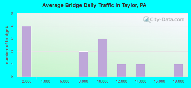
- 83,570Total average daily traffic
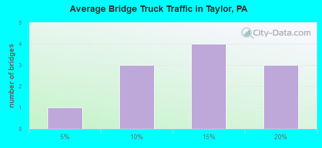
- 7,957Total average daily truck traffic
- National Bridge Inventory (NBI) Registered Bridges for Taylor
- No street view available for this location
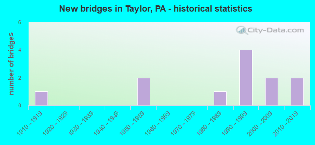
- New bridges - historical statistics
- 11910-1919
- 21950-1959
- 11980-1989
- 41990-1999
- 22000-2009
- 22010-2019
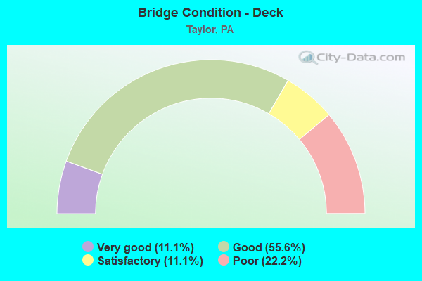
- Bridge Condition - Deck
- 11.1%Very good
- 55.6%Good
- 11.1%Satisfactory
- 22.2%Poor
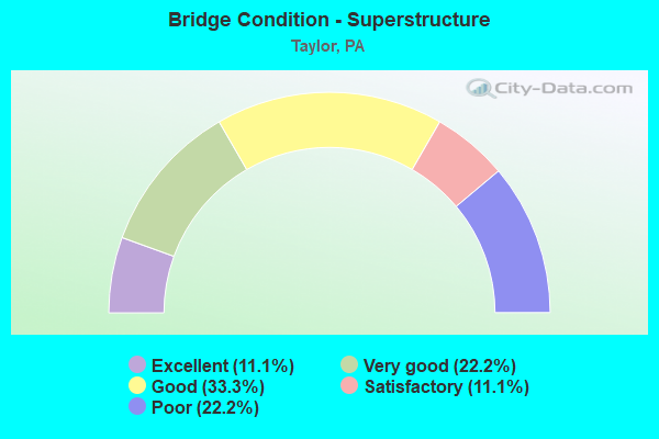
- Bridge Condition - Superstructure
- 11.1%Excellent
- 22.2%Very good
- 33.3%Good
- 11.1%Satisfactory
- 22.2%Poor
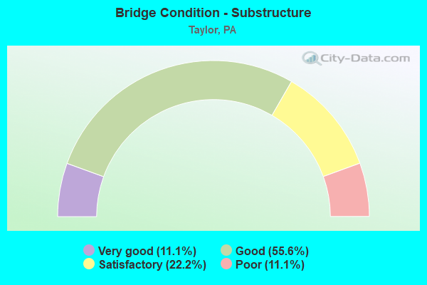
- Bridge Condition - Substructure
- 11.1%Very good
- 55.6%Good
- 22.2%Satisfactory
- 11.1%Poor
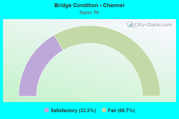
- Bridge Condition - Channel
- 33.3%Satisfactory
- 66.7%Fair
Find on map >> Show street view
Structure Number: 20753, Location: NEWTON TWP .6 M E SR 3001 (Lat: 41.444414, Lng: -75.773083), Route carried "on" structure: State highway , Year Built: 1958, Status: Posted for load, Structure Length: 1.19m (3.90ft), Average Daily Traffic: 244 (year 2022), Truck Traffic: 10%, Average Future Daily Traffic: 402 (year 2032), Design Load: HS 20, Features Intersected: GARDNER CREEK, Facility Carried by Structure: SR 3006
Minimum Vertical Clearance: 30+ m (98+ ft), Kilometerpoint: 3.792, Lanes on structure: 2, Owner: State Highway Agency, Approaching Roadway Width: 5.5m (18.0ft), Skew: 3 degrees, Material/Design: Prestressed concrete, Design/Construction: Box Beam or Girders - Multiple, Number Of Spans In Main Unit: 1, Length of Maximum Span: 11.0m (36.1ft), Curb or Sidewalk Widths: Left: 0.2m (0.7ft), Right: 0.2m (0.7ft), Curb-To-Curb Width: 8.7m (28.5ft), Out-to-Out Width: 9.4m (30.8ft)
Condition: Deck: Poor, Superstructure: Poor, Substructure: Satisfactory, Channel: Fair, Operating Rating: 24.5 metric tons, Method Used To Determine Operating Rating: Load Factor (LF), Inventory Rating: 10.0 metric tons, Method Used To Determine Inventory Rating: Load Factor (LF), Structural Evaluation: High priority of corrective action, Deck Geometry: Equal to present minimum criteria, Waterway Adequacy: Equal to present desirable criteria, Approach Roadway Alignment: Equal to present desirable criteria, Bridge Posting: Required (Relationship of Operating Rating to Maximum Legal Load: > 39.9% below), Length Of Structure Improvement: 1.20m (3.94ft), Designated Inspection Frequency: Every 24 months, Other Special Inspection Frequency: Every 12 months, Inspection Date: November 2019, Other Special Inspection Date: November 2020, Bridge Improvement Cost: $29,000, Roadway Improvement Cost: $196,000, Total Project Cost: $389,000 ( Estimate for 2030), Deck Structure Type: Other, Wearing Surface/Protective System: Wearing Surface: Bituminous
Find on map >> Show street view
Structure Number: 20756, Location: RANSOM TWP 152' N SR 3002 (Lat: 41.423611, Lng: -75.770278), Route carried "on" structure: State highway , Year Built: 1988, Status: Open, Structure Length: 0.67m (2.20ft), Average Daily Traffic: 191 (year 2022), Truck Traffic: 14%, Average Future Daily Traffic: 431 (year 2032), Design Load: HS 25 or greater, Features Intersected: GARDNER CREEK, Facility Carried by Structure: SR 3009
Minimum Vertical Clearance: 30+ m (98+ ft), Kilometerpoint: 0.000, Lanes on structure: 2, Owner: State Highway Agency, Approaching Roadway Width: 8.8m (28.9ft), Skew: 2 degrees, Material/Design: Concrete, Design/Construction: Slab, Number Of Spans In Main Unit: 1, Length of Maximum Span: 6.1m (20.0ft), Curb-To-Curb Width: 8.7m (28.5ft), Out-to-Out Width: 9.7m (31.8ft)
Condition: Deck: Satisfactory, Superstructure: Satisfactory, Substructure: Satisfactory, Channel: Satisfactory, Operating Rating: 68.0 metric tons, Method Used To Determine Operating Rating: Load Factor (LF), Inventory Rating: 40.8 metric tons, Method Used To Determine Inventory Rating: Load Factor (LF), Structural Evaluation: Equal to present minimum criteria, Deck Geometry: Equal to present minimum criteria, Waterway Adequacy: Equal to present desirable criteria, Approach Roadway Alignment: Equal to present desirable criteria, Length Of Structure Improvement: 1.20m (3.94ft), Designated Inspection Frequency: Every 24 months, Inspection Date: July 2020, Wearing Surface/Protective System: Wearing Surface: Bituminous
Find on map >> Show street view
Structure Number: 20764, Location: TAYLOR BO 150' W SR 3010 (Lat: 41.394386, Lng: -75.731250), Route carried "on" structure: State highway , Year Built: 1957, Year Reconstructed: 1995, Status: Open, Structure Length: 0.70m (2.30ft), Average Daily Traffic: 9,285 (year 2022), Truck Traffic: 10%, Average Future Daily Traffic: 10,218 (year 2032), Design Load: HS 25 or greater, Features Intersected: ST JOHNS CREEK, Facility Carried by Structure: SR 3011
Minimum Vertical Clearance: 30+ m (98+ ft), Kilometerpoint: 4.369, Lanes on structure: 4, Base Highway Network: Yes, Owner: State Highway Agency, Approaching Roadway Width: 19.5m (64.0ft), Skew: 4 degrees, Material/Design: Concrete, Design/Construction: Slab, Number Of Spans In Main Unit: 1, Length of Maximum Span: 6.4m (21.0ft), Curb-To-Curb Width: 19.5m (64.0ft), Out-to-Out Width: 21.0m (68.9ft)
Condition: Deck: Good, Superstructure: Good, Substructure: Good, Channel: Fair, Operating Rating: 88.9 metric tons, Method Used To Determine Operating Rating: Load Factor (LF), Inventory Rating: 52.6 metric tons, Method Used To Determine Inventory Rating: Load Factor (LF), Structural Evaluation: Better than present minimum criteria, Deck Geometry: Better than present minimum criteria, Waterway Adequacy: Equal to present minimum criteria, Approach Roadway Alignment: Equal to present desirable criteria, Length Of Structure Improvement: 1.30m (4.27ft), Designated Inspection Frequency: Every 24 months, Inspection Date: July 2020, Wearing Surface/Protective System: Wearing Surface: Monolithic Concrete, Deck Protection: Epoxy Coated Reinforcing
Find on map >> Show street view
Structure Number: 20777, Location: TAYLOR BOR 200' E SR 3013 (Lat: 41.383500, Lng: -75.708439), Route carried "on" structure: State highway , Year Built: 1990, Status: Open, Structure Length: 18.53m (60.79ft), Average Daily Traffic: 16,196 (year 2021), Truck Traffic: 5%, Average Future Daily Traffic: 19,571 (year 2032), Design Load: HS 25 or greater, Features Intersected: RBMN RR & LACKA RIVER, Facility Carried by Structure: SR 3016 DAVIS ST
Minimum Vertical Clearance: 30+ m (98+ ft), Kilometerpoint: 0.000, Lanes on structure: 2, Base Highway Network: Yes, Owner: State Highway Agency, Approaching Roadway Width: 13.4m (44.0ft), Material/Design: Prestressed concrete continuous, Design/Construction: Stringer/Multi-beam, Number Of Spans In Main Unit: 5, Length of Maximum Span: 40.5m (132.9ft), Curb or Sidewalk Widths: Left: 0.2m (0.7ft), Right: 0.2m (0.7ft), Curb-To-Curb Width: 13.4m (44.0ft), Out-to-Out Width: 14.2m (46.6ft)
Condition: Deck: Good, Superstructure: Good, Substructure: Good, Channel: Satisfactory, Operating Rating: 88.0 metric tons, Method Used To Determine Operating Rating: Load Factor (LF), Inventory Rating: 30.8 metric tons, Method Used To Determine Inventory Rating: Load Factor (LF), Structural Evaluation: Better than present minimum criteria, Deck Geometry: Equal to present minimum criteria, Underclear: High priority of corrective action, Waterway Adequacy: Superior to present desirable criteria, Approach Roadway Alignment: Equal to present desirable criteria, Length Of Structure Improvement: 19.20m (62.99ft), Designated Inspection Frequency: Every 24 months, Underwater Inspection Frequency: Every 60 months, Inspection Date: July 2020, Underwater Inspection Date: April 2019, Deck Structure Type: Concrete Cast-file-Place, Wearing Surface/Protective System: Wearing Surface: Monolithic Concrete, Deck Protection: Epoxy Coated Reinforcing
Find on map >> Show street view
Structure Number: 20947, Location: TAYLOR BOROUGH (Lat: 41.396231, Lng: -75.731031), Route carried "on" structure: Interstate 476, Year Built: 1995, Status: Open, Structure Length: 5.39m (17.68ft), Average Daily Traffic: 6,895 (year 2001), Truck Traffic: 19%, Average Future Daily Traffic: 101,587 (year 2030), Design Load: HS 25 or greater, Features Intersected: SR 3011, LR35049
Minimum Vertical Clearance: 30+ m (98+ ft), Kilometerpoint: 0.000, Lanes on structure: 5, Lanes under structure: 3, Base Highway Network: Yes, Toll: On toll road, Owner: State Toll Authority, Approaching Roadway Width: 26.8m (87.9ft), Skew: 34 degrees, Material/Design: Steel, Design/Construction: Stringer/Multi-beam, Number Of Spans In Main Unit: 1, Length of Maximum Span: 51.8m (169.9ft), Curb or Sidewalk Widths: Left: 0.2m (0.7ft), Right: 0.2m (0.7ft), Curb-To-Curb Width: 25.9m (85.0ft), Out-to-Out Width: 27.9m (91.5ft)
Condition: Deck: Good, Superstructure: Very good, Substructure: Good, Operating Rating: 43.5 metric tons, Method Used To Determine Operating Rating: Load Factor (LF), Inventory Rating: 26.3 metric tons, Method Used To Determine Inventory Rating: Load Factor (LF), Structural Evaluation: Equal to present minimum criteria, Deck Geometry: Superior to present desirable criteria, Underclear: Equal to present minimum criteria, Approach Roadway Alignment: Equal to present desirable criteria, Length Of Structure Improvement: 7.60m (24.93ft), Designated Inspection Frequency: Every 24 months, Inspection Date: June 2021, Bridge Improvement Cost: $237,000, Roadway Improvement Cost: $699,000, Total Project Cost: $3,203,000, Deck Structure Type: Concrete Cast-file-Place, Wearing Surface/Protective System: Wearing Surface: Latex Concrete, Deck Protection: Epoxy Coated Reinforcing
Find on map >> Show street view
Structure Number: 20948, Location: KEYSER AVE. INTERCHANGE (Lat: 41.395000, Lng: -75.723333), Route carried "on" structure: Ramp Interstate 476, Year Built: 1994, Status: Open, Structure Length: 1.37m (4.49ft), Average Daily Traffic: 6,895 (year 2001), Truck Traffic: 19%, Average Future Daily Traffic: 16,997 (year 2030), Design Load: HS 25 or greater, Features Intersected: ST. JOHN'S CREEK, Facility Carried by Structure: PA TPK (RAMP B)
Minimum Vertical Clearance: 30+ m (98+ ft), Kilometerpoint: 0.000, Lanes on structure: 1, Base Highway Network: Yes, Toll: On toll road, Owner: State Toll Authority, Approaching Roadway Width: 9.4m (30.8ft), Skew: 6 degrees, Material/Design: Concrete, Design/Construction: Culvert, Number Of Spans In Main Unit: 1, Length of Maximum Span: 13.7m (44.9ft)
Condition: Channel: Fair, Culverts: Good, Inventory Rating: 99.8 metric tons, Method Used To Determine Inventory Rating: Load Factor (LF), Structural Evaluation: Better than present minimum criteria, Waterway Adequacy: Superior to present desirable criteria, Approach Roadway Alignment: Equal to present desirable criteria, Designated Inspection Frequency: Every 48 months, Inspection Date: June 2019
Find on map >> Show street view
Structure Number: 44285, Location: TAYLOR BORO (Lat: 41.410383, Lng: -75.720558), Route carried "on" structure: State highway , Year Built: 2007, Status: Open, Structure Length: 3.84m (12.60ft), Average Daily Traffic: 754 (year 2022), Truck Traffic: 7%, Average Future Daily Traffic: 1,273 (year 2032), Design Load: HL 93, Features Intersected: PA TURNPIKE, Facility Carried by Structure: S.R. 3002
Minimum Vertical Clearance: 30+ m (98+ ft), Kilometerpoint: 7.818, Lanes on structure: 2, Lanes under structure: 4, Owner: State Highway Agency, Approaching Roadway Width: 7.0m (23.0ft), Skew: 4 degrees, Material/Design: Steel, Design/Construction: Stringer/Multi-beam, Number Of Spans In Main Unit: 1, Length of Maximum Span: 36.0m (118.1ft), Curb-To-Curb Width: 11.0m (36.1ft), Out-to-Out Width: 12.0m (39.4ft)
Condition: Deck: Good, Superstructure: Good, Substructure: Good, Operating Rating: 93.4 metric tons, Method Used To Determine Operating Rating: Load Factor (LF), Inventory Rating: 56.2 metric tons, Method Used To Determine Inventory Rating: Load Factor (LF), Structural Evaluation: Better than present minimum criteria, Deck Geometry: Better than present minimum criteria, Underclear: High priority of corrective action, Approach Roadway Alignment: Equal to present desirable criteria, Designated Inspection Frequency: Every 24 months, Inspection Date: August 2020, Deck Structure Type: Concrete Cast-file-Place, Wearing Surface/Protective System: Wearing Surface: Monolithic Concrete, Deck Protection: Epoxy Coated Reinforcing
Find on map >> Show street view
Structure Number: 48391, Location: 225 FT S OAK ST INTERSCT (Lat: 41.390064, Lng: -75.698311), Route carried "on" structure: State highway , Year Built: 2013, Status: Open, Structure Length: 4.33m (14.21ft), Average Daily Traffic: 13,981 (year 2022), Truck Traffic: 6%, Average Future Daily Traffic: 17,622 (year 2036), Design Load: HL 93, Features Intersected: CP RAIL/D&H RAILROAD, Facility Carried by Structure: SR 3013 MAIN ST
Minimum Vertical Clearance: 30+ m (98+ ft), Kilometerpoint: 6.206, Lanes on structure: 3, Owner: County Highway Agency, Approaching Roadway Width: 12.8m (42.0ft), Material/Design: Prestressed concrete continuous, Design/Construction: Box Beam or Girders - Multiple, Number Of Spans In Main Unit: 2, Length of Maximum Span: 21.0m (68.9ft), Curb or Sidewalk Widths: Left: 1.5m (4.9ft), Right: 0.2m (0.7ft), Curb-To-Curb Width: 12.7m (41.7ft), Out-to-Out Width: 15.0m (49.2ft)
Condition: Deck: Good, Superstructure: Excellent, Substructure: Good, Operating Rating: 66.2 metric tons, Method Used To Determine Operating Rating: Load and Resistance Factor (LRFR), Inventory Rating: 39.9 metric tons, Method Used To Determine Inventory Rating: Load and Resistance Factor (LRFR), Structural Evaluation: Better than present minimum criteria, Deck Geometry: Meets minimum limits, Underclear: High priority of corrective action, Approach Roadway Alignment: Somewhat better than minimum adequacy, Designated Inspection Frequency: Every 24 months, Inspection Date: December 2019, Deck Structure Type: Concrete Cast-file-Place, Wearing Surface/Protective System: Wearing Surface: Monolithic Concrete, Deck Protection: Epoxy Coated Reinforcing
Find on map >> Show street view
Structure Number: 54784, Location: TAYLOR BO .7M N SR 3016 (Lat: 41.377806, Lng: -75.720806), Route carried "on" structure: State highway , Year Built: 2017, Status: Open, Structure Length: 3.69m (12.11ft), Average Daily Traffic: 11,600 (year 2022), Truck Traffic: 3%, Average Future Daily Traffic: 13,848 (year 2038), Design Load: HL 93, Features Intersected: PA TPK (Toll 476), Facility Carried by Structure: SR 3013
Minimum Vertical Clearance: 30+ m (98+ ft), Kilometerpoint: 3.401, Lanes on structure: 2, Lanes under structure: 4, Owner: State Toll Authority, Approaching Roadway Width: 15.2m (49.9ft), Skew: 1 degrees, Material/Design: Steel, Design/Construction: Stringer/Multi-beam, Number Of Spans In Main Unit: 2, Length of Maximum Span: 18.0m (59.1ft), Curb or Sidewalk Widths: Left: 1.7m (5.6ft), Right: 1.7m (5.6ft), Curb-To-Curb Width: 15.8m (51.8ft), Out-to-Out Width: 19.9m (65.3ft)
Condition: Deck: Very good, Superstructure: Very good, Substructure: Very good, Operating Rating: 47.6 metric tons, Method Used To Determine Operating Rating: Assigned ratings based on Load and Resistance Factor Design (LRFD) reported by rating factor (RF) using HL93 loadings, Inventory Rating: 36.6 metric tons, Method Used To Determine Inventory Rating: Assigned ratings based on Load and Resistance Factor Design (LRFD) reported by rating factor (RF) using HL93 loadings, Structural Evaluation: Equal to present desirable criteria, Deck Geometry: Superior to present desirable criteria, Underclear: Better than present minimum criteria, Approach Roadway Alignment: Equal to present desirable criteria, Designated Inspection Frequency: Every 48 months, Inspection Date: November 2019, Deck Structure Type: Concrete Cast-file-Place, Wearing Surface/Protective System: Wearing Surface: Monolithic Concrete, Deck Protection: Epoxy Coated Reinforcing
Find on map >> Show street view
Structure Number: 57681, Location: 0.4 MILES S SR 3012 (Lat: 41.387583, Lng: -75.704722), Route carried "on" structure: City street , Year Built: 1910, Status: Posted for load, Structure Length: 0.79m (2.59ft), Average Daily Traffic: 100 (year 2020), Average Future Daily Traffic: 100 (year 2040), Features Intersected: KEYSER CREEK, Facility Carried by Structure: OLD MAIN STREET
Minimum Vertical Clearance: 30+ m (98+ ft), Kilometerpoint: 0.000, Lanes on structure: 2, Owner: County Highway Agency, Approaching Roadway Width: 11.6m (38.1ft), Skew: 4 degrees, Material/Design: Steel, Number Of Spans In Main Unit: 1, Length of Maximum Span: 7.6m (24.9ft), Curb-To-Curb Width: 14.8m (48.6ft), Out-to-Out Width: 15.4m (50.5ft)
Condition: Deck: Poor, Superstructure: Poor, Substructure: Poor, Channel: Fair, Operating Rating: 36.3 metric tons, Method Used To Determine Operating Rating: Field evaluation and documented engineering judgment, Inventory Rating: 21.8 metric tons, Method Used To Determine Inventory Rating: Field evaluation and documented engineering judgment, Structural Evaluation: Meets minimum limits, Deck Geometry: Superior to present desirable criteria, Waterway Adequacy: Equal to present minimum criteria, Approach Roadway Alignment: Equal to present desirable criteria, Bridge Posting: Required (Relationship of Operating Rating to Maximum Legal Load: 20.0 - 29.9% below), Length Of Structure Improvement: 0.80m (2.62ft), Designated Inspection Frequency: Every 24 months, Other Special Inspection Frequency: Every 12 months, Inspection Date: April 2020, Other Special Inspection Date: April 2021, Deck Structure Type: Concrete Cast-file-Place, Wearing Surface/Protective System: Wearing Surface: Bituminous
Find on map >> Show street view
Structure Number: 20947, Location: TAYLOR BOROUGH (Lat: 41.396231, Lng: -75.731031), Route carried "under" structure: State highway , Year Built: 1995, Structure Length: 0. m, Average Daily Traffic: 9,285 (year 2022), Truck Traffic: 10%, Features Intersected: SR 3011, LR35049, Facility Carried by Structure: PA TPK (I-476)
Minimum Vertical Clearance: 6.06m (19.88ft), Kilometerpoint: 4.369, Lanes on structure: 5, Lanes under structure: 3, Material/Design: Steel, Design/Construction: Stringer/Multi-beam, Length of Maximum Span: 51.8m (169.9ft)
Find on map >> Show street view
Structure Number: 44285, Location: TAYLOR BORO (Lat: 41.410383, Lng: -75.720558), Route carried "under" structure: Interstate 476, Year Built: 2007, Structure Length: 0. m, Average Daily Traffic: 8,144 (year 2007), Truck Traffic: 17%, Features Intersected: PA TURNPIKE, Facility Carried by Structure: S.R. 3002
Minimum Vertical Clearance: 5.36m (17.59ft), Kilometerpoint: 198.496, Lanes on structure: 2, Lanes under structure: 4, Toll: On toll road, Material/Design: Steel, Design/Construction: Stringer/Multi-beam, Length of Maximum Span: 36.0m (118.1ft)