Bridge Statistics for Taylorsville, Utah (UT)
Condition, Traffic, Stress, Structural Evaluation, Project Costs
- National Bridge Inventory (NBI) Statistics
- 44Number of bridges
- 302ft / 91.6mTotal length
- 1,744,677Total average daily traffic
- 266,623Total average daily truck traffic
- National Bridge Inventory (NBI) Registered Bridges for Taylorsville
- No street view available for this location

- New bridges - historical statistics
- 81960-1969
- 221970-1979
- 41980-1989
- 41990-1999
- 42010-2019
- 22020-2022
- Bridge Condition - Deck
- 11.5%Very good
- 3.8%Good
- 69.2%Satisfactory
- 15.4%Fair
- Bridge Condition - Superstructure
- 11.5%Very good
- 34.6%Good
- 38.5%Satisfactory
- 7.7%Fair
- 7.7%Poor
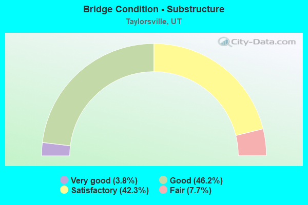
- Bridge Condition - Substructure
- 3.8%Very good
- 46.2%Good
- 42.3%Satisfactory
- 7.7%Fair
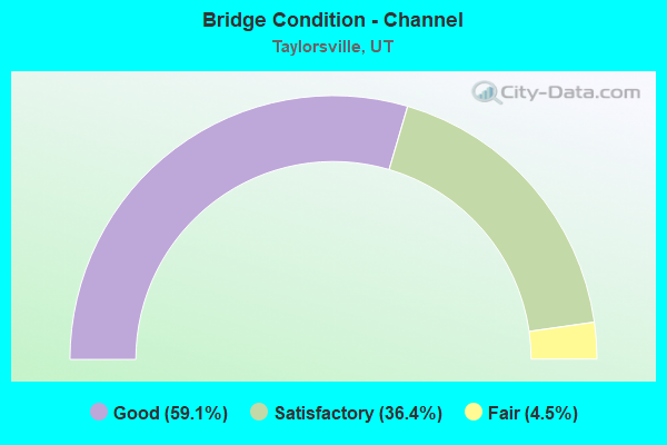
- Bridge Condition - Channel
- 59.1%Good
- 36.4%Satisfactory
- 4.5%Fair
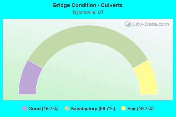
- Bridge Condition - Culverts
- 16.7%Good
- 66.7%Satisfactory
- 16.7%Fair
Find on map >> Show street view
Structure Number: 35012D, Location: 650 W. 4800 S., TAYLORSV. (Lat: 40.666864, Lng: -111.908653), Route carried "on" structure: City street 2142, Year Built: 1960, Status: Open, Structure Length: 1.68m (5.51ft), Average Daily Traffic: 8,378 (year 2020), Average Future Daily Traffic: 10,473 (year 2040), Design Load: HS 20+Mod, Features Intersected: JORDAN RIVER, Facility Carried by Structure: 4800 SOUTH STREET
Minimum Vertical Clearance: 30+ m (98+ ft), Kilometerpoint: 2.589, Lanes on structure: 2, Owner: City or Municipal Highway Agency, Approaching Roadway Width: 9.7m (31.8ft), Material/Design: Concrete, Design/Construction: Frame, Number Of Spans In Main Unit: 1, Length of Maximum Span: 15.2m (49.9ft), Curb or Sidewalk Widths: Left: 1.5m (4.9ft), Right: 1.5m (4.9ft), Curb-To-Curb Width: 9.7m (31.8ft), Out-to-Out Width: 12.8m (42.0ft)
Condition: Deck: Satisfactory, Superstructure: Satisfactory, Substructure: Satisfactory, Channel: Good, Operating Rating: 60.3 metric tons, Method Used To Determine Operating Rating: Load and Resistance Factor Rating (LRFR) rating reported by rating factor(RF) method using HL-93 loadings, Inventory Rating: 32.4 metric tons, Method Used To Determine Inventory Rating: Load and Resistance Factor Rating (LRFR) rating reported by rating factor(RF) method using HL-93 loadings, Structural Evaluation: Equal to present minimum criteria, Deck Geometry: High priority of corrective action, Waterway Adequacy: Better than present minimum criteria, Approach Roadway Alignment: Somewhat better than minimum adequacy, Designated Inspection Frequency: Every 24 months, Inspection Date: Febuary 2020, Deck Structure Type: Concrete Cast-file-Place, Wearing Surface/Protective System: Wearing Surface: Bituminous
Find on map >> Show street view
Structure Number: 35082D, Location: 5900 S. 2700 W.,TAYLORSV. (Lat: 40.644875, Lng: -111.957858), Route carried "on" structure: City street 2040, Year Built: 1969, Status: Open, Structure Length: 0.86m (2.82ft), Average Daily Traffic: 12,140 (year 2020), Average Future Daily Traffic: 15,175 (year 2040), Design Load: HS 20+Mod, Features Intersected: UTAH AND SALT LAKE CAN, Facility Carried by Structure: 2700 WEST STREET
Minimum Vertical Clearance: 30+ m (98+ ft), Kilometerpoint: 19.542, Lanes on structure: 2, Owner: City or Municipal Highway Agency, Approaching Roadway Width: 11.3m (37.1ft), Skew: 3 degrees, Material/Design: Concrete, Design/Construction: Slab, Number Of Spans In Main Unit: 1, Length of Maximum Span: 8.1m (26.6ft), Curb or Sidewalk Widths: Left: 2.0m (6.6ft), Right: 2.6m (8.5ft), Curb-To-Curb Width: 11.3m (37.1ft), Out-to-Out Width: 24.6m (80.7ft)
Condition: Deck: Fair, Superstructure: Fair, Substructure: Satisfactory, Channel: Good, Operating Rating: 32.4 metric tons, Method Used To Determine Operating Rating: Load and Resistance Factor Rating (LRFR) rating reported by rating factor(RF) method using HL-93 loadings, Inventory Rating: 19.4 metric tons, Method Used To Determine Inventory Rating: Load Factor (LF) rating reported by rating factor (RF) method using MS18 loading, Structural Evaluation: Meets minimum limits, Deck Geometry: Meets minimum limits, Waterway Adequacy: Better than present minimum criteria, Approach Roadway Alignment: Equal to present desirable criteria, Designated Inspection Frequency: Every 24 months, Inspection Date: January 2022, Deck Structure Type: Concrete Cast-file-Place, Wearing Surface/Protective System: Wearing Surface: Bituminous
Find on map >> Show street view
Structure Number: 35083D, Location: 2225 W. 6200 S.,TAYLORSV. (Lat: 40.638578, Lng: -111.948897), Route carried "on" structure: City street 2120, Year Built: 1994, Status: Open, Structure Length: 0.78m (2.56ft), Average Daily Traffic: 22,151 (year 2020), Average Future Daily Traffic: 27,689 (year 2040), Design Load: HL 93, Features Intersected: UTAH AND SALT LAKE CAN, Facility Carried by Structure: 6200 SOUTH STREET
Minimum Vertical Clearance: 30+ m (98+ ft), Kilometerpoint: 6.399, Lanes on structure: 4, Owner: City or Municipal Highway Agency, Approaching Roadway Width: 16.8m (55.1ft), Skew: 2 degrees, Material/Design: Concrete, Design/Construction: Frame, Number Of Spans In Main Unit: 1, Length of Maximum Span: 7.1m (23.3ft), Curb or Sidewalk Widths: Left: 2.7m (8.9ft), Right: 2.7m (8.9ft), Curb-To-Curb Width: 16.8m (55.1ft), Out-to-Out Width: 26.0m (85.3ft)
Condition: Deck: Satisfactory, Superstructure: Satisfactory, Substructure: Good, Channel: Satisfactory, Operating Rating: 32.4 metric tons, Method Used To Determine Operating Rating: Load and Resistance Factor Rating (LRFR) rating reported by rating factor(RF) method using HL-93 loadings, Inventory Rating: 19.4 metric tons, Method Used To Determine Inventory Rating: Load Factor (LF) rating reported by rating factor (RF) method using MS18 loading, Structural Evaluation: Meets minimum limits, Deck Geometry: Somewhat better than minimum adequacy, Waterway Adequacy: Equal to present desirable criteria, Approach Roadway Alignment: Equal to present desirable criteria, Designated Inspection Frequency: Every 24 months, Inspection Date: January 2022, Deck Structure Type: Concrete Precast Panels, Wearing Surface/Protective System: Wearing Surface: Bituminous
Find on map >> Show street view
Structure Number: 35084C, Location: 6225 S. 2200 W.,TAYLORSV. (Lat: 40.637936, Lng: -111.948342), Route carried "on" structure: City street 2085, Year Built: 1981, Status: Open, Structure Length: 0.94m (3.08ft), Average Daily Traffic: 1,000 (year 2020), Average Future Daily Traffic: 1,250 (year 2040), Design Load: HS 20+Mod, Features Intersected: UT AND SL CANAL, Facility Carried by Structure: 2200 WEST STREET
Minimum Vertical Clearance: 30+ m (98+ ft), Kilometerpoint: 10.417, Lanes on structure: 2, Owner: City or Municipal Highway Agency, Approaching Roadway Width: 14.0m (45.9ft), Skew: 24 degrees, Material/Design: Steel, Design/Construction: Stringer/Multi-beam, Number Of Spans In Main Unit: 1, Length of Maximum Span: 7.5m (24.6ft), Curb or Sidewalk Widths: Left: 2.7m (8.9ft), Right: 2.7m (8.9ft), Curb-To-Curb Width: 14.0m (45.9ft), Out-to-Out Width: 29.7m (97.4ft)
Condition: Deck: Satisfactory, Superstructure: Satisfactory, Substructure: Good, Channel: Good, Operating Rating: 37.6 metric tons, Method Used To Determine Operating Rating: Load and Resistance Factor Rating (LRFR) rating reported by rating factor(RF) method using HL-93 loadings, Inventory Rating: 32.4 metric tons, Method Used To Determine Inventory Rating: Load and Resistance Factor Rating (LRFR) rating reported by rating factor(RF) method using HL-93 loadings, Structural Evaluation: Equal to present minimum criteria, Deck Geometry: Superior to present desirable criteria, Waterway Adequacy: Better than present minimum criteria, Approach Roadway Alignment: Equal to present desirable criteria, Designated Inspection Frequency: Every 24 months, Inspection Date: Febuary 2020, Deck Structure Type: Concrete Cast-file-Place, Wearing Surface/Protective System: Wearing Surface: Bituminous, Deck Protection: Epoxy Coated Reinforcing
Find on map >> Show street view
Structure Number: 35085F, Location: 6440 S. 2200 W.,TAYLORSV. (Lat: 40.634008, Lng: -111.948319), Route carried "on" structure: City street 2085, Year Built: 1975, Status: Open, Structure Length: 0.87m (2.85ft), Average Daily Traffic: 1,000 (year 2020), Average Future Daily Traffic: 1,250 (year 2040), Design Load: HS 20+Mod, Features Intersected: UTAH AND SALT LAKE CAN, Facility Carried by Structure: 2200 WEST STREET
Minimum Vertical Clearance: 30+ m (98+ ft), Kilometerpoint: 9.981, Lanes on structure: 2, Owner: City or Municipal Highway Agency, Approaching Roadway Width: 13.7m (44.9ft), Skew: 1 degrees, Material/Design: Prestressed concrete, Design/Construction: Tee Beam, Number Of Spans In Main Unit: 1, Length of Maximum Span: 7.7m (25.3ft), Curb or Sidewalk Widths: Left: 2.7m (8.9ft), Right: 2.7m (8.9ft), Curb-To-Curb Width: 13.7m (44.9ft), Out-to-Out Width: 21.4m (70.2ft)
Condition: Deck: Satisfactory, Superstructure: Fair, Substructure: Satisfactory, Channel: Good, Operating Rating: 40.5 metric tons, Method Used To Determine Operating Rating: Load and Resistance Factor Rating (LRFR) rating reported by rating factor(RF) method using HL-93 loadings, Inventory Rating: 25.3 metric tons, Method Used To Determine Inventory Rating: Load Factor (LF) rating reported by rating factor (RF) method using MS18 loading, Structural Evaluation: Somewhat better than minimum adequacy, Deck Geometry: Superior to present desirable criteria, Waterway Adequacy: Better than present minimum criteria, Approach Roadway Alignment: Equal to present desirable criteria, Designated Inspection Frequency: Every 24 months, Inspection Date: January 2022, Deck Structure Type: Concrete Precast Panels, Wearing Surface/Protective System: Wearing Surface: Bituminous
Find on map >> Show street view
Structure Number: 35086D, Location: 5380 S. 3200 W.,TAYLORSV. (Lat: 40.654169, Lng: -111.967403), Route carried "on" structure: City street 2094, Year Built: 1965, Status: Open, Structure Length: 0.91m (2.99ft), Average Daily Traffic: 8,833 (year 2020), Average Future Daily Traffic: 11,041 (year 2040), Design Load: HL 93, Features Intersected: UTAH AND SALT LAKE CANAL, Facility Carried by Structure: 3200 WEST STREET
Minimum Vertical Clearance: 30+ m (98+ ft), Kilometerpoint: 13.051, Lanes on structure: 2, Owner: City or Municipal Highway Agency, Approaching Roadway Width: 13.7m (44.9ft), Skew: 3 degrees, Material/Design: Concrete, Design/Construction: Slab, Number Of Spans In Main Unit: 1, Length of Maximum Span: 8.4m (27.6ft), Curb or Sidewalk Widths: Left: 0.0m, Right: 3.7m (12.1ft), Curb-To-Curb Width: 13.7m (44.9ft), Out-to-Out Width: 23.0m (75.5ft)
Condition: Deck: Satisfactory, Superstructure: Satisfactory, Substructure: Good, Channel: Satisfactory, Operating Rating: 32.4 metric tons, Method Used To Determine Operating Rating: Load and Resistance Factor Rating (LRFR) rating reported by rating factor(RF) method using HL-93 loadings, Inventory Rating: 20.7 metric tons, Method Used To Determine Inventory Rating: Load Factor (LF) rating reported by rating factor (RF) method using MS18 loading, Structural Evaluation: Somewhat better than minimum adequacy, Deck Geometry: Superior to present desirable criteria, Waterway Adequacy: Better than present minimum criteria, Approach Roadway Alignment: Equal to present desirable criteria, Designated Inspection Frequency: Every 24 months, Inspection Date: January 2022, Deck Structure Type: Concrete Cast-file-Place, Wearing Surface/Protective System: Wearing Surface: Bituminous
Find on map >> Show street view
Structure Number: 35087D, Location: 4990 S. 3600 W.,TAYLORSV. (Lat: 40.660300, Lng: -111.977000), Route carried "on" structure: City street 2164, Year Built: 1971, Status: Open, Structure Length: 1.09m (3.58ft), Average Daily Traffic: 7,498 (year 2020), Average Future Daily Traffic: 9,373 (year 2040), Design Load: HL 93, Features Intersected: UTAH AND SALT LAKE CAN, Facility Carried by Structure: 3600 WEST STREET
Minimum Vertical Clearance: 30+ m (98+ ft), Kilometerpoint: 0.806, Lanes on structure: 2, Owner: City or Municipal Highway Agency, Approaching Roadway Width: 13.6m (44.6ft), Skew: 3 degrees, Material/Design: Concrete, Design/Construction: Slab, Number Of Spans In Main Unit: 1, Length of Maximum Span: 10.5m (34.4ft), Curb or Sidewalk Widths: Left: 0.0m, Right: 2.7m (8.9ft), Curb-To-Curb Width: 13.6m (44.6ft), Out-to-Out Width: 24.7m (81.0ft)
Condition: Deck: Satisfactory, Superstructure: Satisfactory, Substructure: Good, Channel: Satisfactory, Operating Rating: 32.4 metric tons, Method Used To Determine Operating Rating: Load and Resistance Factor Rating (LRFR) rating reported by rating factor(RF) method using HL-93 loadings, Inventory Rating: 21.4 metric tons, Method Used To Determine Inventory Rating: Load Factor (LF) rating reported by rating factor (RF) method using MS18 loading, Structural Evaluation: Somewhat better than minimum adequacy, Deck Geometry: Superior to present desirable criteria, Waterway Adequacy: Better than present minimum criteria, Approach Roadway Alignment: Equal to present desirable criteria, Designated Inspection Frequency: Every 24 months, Inspection Date: January 2022, Deck Structure Type: Concrete Cast-file-Place, Wearing Surface/Protective System: Wearing Surface: Bituminous
Find on map >> Show street view
Structure Number: 35089D, Location: 4750 S. 4000 W.,TAYLORSV. (Lat: 40.666653, Lng: -111.986725), Route carried "on" structure: City street 2160, Year Built: 1965, Status: Open, Structure Length: 0.91m (2.99ft), Average Daily Traffic: 2,679 (year 2020), Average Future Daily Traffic: 3,349 (year 2040), Design Load: HL 93, Features Intersected: UTAH AND SALT LAKE CAN, Facility Carried by Structure: 4000 WEST STREET
Minimum Vertical Clearance: 30+ m (98+ ft), Kilometerpoint: 3.125, Lanes on structure: 3, Owner: City or Municipal Highway Agency, Approaching Roadway Width: 15.8m (51.8ft), Skew: 3 degrees, Material/Design: Concrete, Design/Construction: Slab, Number Of Spans In Main Unit: 1, Length of Maximum Span: 8.4m (27.6ft), Curb-To-Curb Width: 15.8m (51.8ft), Out-to-Out Width: 18.4m (60.4ft)
Condition: Deck: Satisfactory, Superstructure: Satisfactory, Substructure: Satisfactory, Channel: Good, Operating Rating: 32.4 metric tons, Method Used To Determine Operating Rating: Load and Resistance Factor Rating (LRFR) rating reported by rating factor(RF) method using HL-93 loadings, Inventory Rating: 20.4 metric tons, Method Used To Determine Inventory Rating: Load Factor (LF) rating reported by rating factor (RF) method using MS18 loading, Structural Evaluation: Somewhat better than minimum adequacy, Deck Geometry: Better than present minimum criteria, Waterway Adequacy: Equal to present minimum criteria, Approach Roadway Alignment: Equal to present minimum criteria, Designated Inspection Frequency: Every 24 months, Inspection Date: January 2022, Deck Structure Type: Concrete Cast-file-Place, Wearing Surface/Protective System: Wearing Surface: Bituminous
Find on map >> Show street view
Structure Number: 35090F, Location: 1100 W. 3950 S., SL.CO. (Lat: 40.686278, Lng: -111.921353), Route carried "on" structure: County highway 2172, Year Built: 1966, Status: Open, Structure Length: 3.69m (12.11ft), Average Daily Traffic: 27,378 (year 2020), Average Future Daily Traffic: 34,223 (year 2040), Design Load: HS 20+Mod, Features Intersected: JORDAN RIVER, Facility Carried by Structure: 3950 SOUTH STREET
Minimum Vertical Clearance: 30+ m (98+ ft), Kilometerpoint: 14.486, Lanes on structure: 4, Owner: City or Municipal Highway Agency, Approaching Roadway Width: 24.4m (80.1ft), Skew: 22 degrees, Material/Design: Prestressed concrete, Design/Construction: Stringer/Multi-beam, Number Of Spans In Main Unit: 3, Length of Maximum Span: 12.0m (39.4ft), Curb-To-Curb Width: 24.4m (80.1ft), Out-to-Out Width: 25.0m (82.0ft)
Condition: Deck: Satisfactory, Superstructure: Satisfactory, Substructure: Fair, Channel: Fair, Operating Rating: 65.4 metric tons, Method Used To Determine Operating Rating: Load and Resistance Factor Rating (LRFR) rating reported by rating factor(RF) method using HL-93 loadings, Inventory Rating: 47.6 metric tons, Method Used To Determine Inventory Rating: Load Factor (LF) rating reported by rating factor (RF) method using MS18 loading, Structural Evaluation: Somewhat better than minimum adequacy, Deck Geometry: Superior to present desirable criteria, Waterway Adequacy: Equal to present desirable criteria, Approach Roadway Alignment: Equal to present desirable criteria, Designated Inspection Frequency: Every 24 months, Inspection Date: December 2021, Deck Structure Type: Concrete Cast-file-Place, Wearing Surface/Protective System: Wearing Surface: Bituminous, Membrane: Preformed Fabric
Find on map >> Show street view
Structure Number: 35118F, Location: 2600 W. 4200 S.,TAYLORSV. (Lat: 40.679778, Lng: -111.955056), Route carried "on" structure: City street , Year Built: 1970, Status: Posted for load, Structure Length: 0.78m (2.56ft), Average Daily Traffic: 1,197 (year 2020), Truck Traffic: 1%, Average Future Daily Traffic: 1,454 (year 2040), Design Load: HL 93, Features Intersected: NORTH JORDAN CANAL, Facility Carried by Structure: DUTCH DRAW DRIVE
Minimum Vertical Clearance: 30+ m (98+ ft), Kilometerpoint: 0.000, Lanes on structure: 2, Owner: City or Municipal Highway Agency, Approaching Roadway Width: 11.8m (38.7ft), Material/Design: Prestressed concrete, Design/Construction: Tee Beam, Number Of Spans In Main Unit: 1, Length of Maximum Span: 6.8m (22.3ft), Curb or Sidewalk Widths: Left: 3.0m (9.8ft), Right: 2.8m (9.2ft), Curb-To-Curb Width: 11.8m (38.7ft), Out-to-Out Width: 18.1m (59.4ft)
Condition: Deck: Satisfactory, Superstructure: Poor, Substructure: Satisfactory, Channel: Good, Operating Rating: 25.9 metric tons, Method Used To Determine Operating Rating: Load and Resistance Factor Rating (LRFR) rating reported by rating factor(RF) method using HL-93 loadings, Inventory Rating: 16.2 metric tons, Method Used To Determine Inventory Rating: Load and Resistance Factor Rating (LRFR) rating reported by rating factor(RF) method using HL-93 loadings, Structural Evaluation: Meets minimum limits, Deck Geometry: Equal to present minimum criteria, Waterway Adequacy: Better than present minimum criteria, Approach Roadway Alignment: Equal to present desirable criteria, Bridge Posting: Required (Relationship of Operating Rating to Maximum Legal Load: 20.0 - 29.9% below), Designated Inspection Frequency: Every 24 months, Inspection Date: January 2022, Deck Structure Type: Concrete Precast Panels, Wearing Surface/Protective System: Wearing Surface: Bituminous
Find on map >> Show street view
Structure Number: 35125C, Location: 1300 W. 5800 S., MURRAY (Lat: 40.647253, Lng: -111.929336), Route carried "on" structure: City street , Year Built: 1986, Status: Open, Structure Length: 0.77m (2.53ft), Average Daily Traffic: 6,647 (year 2020), Truck Traffic: 1%, Average Future Daily Traffic: 8,075 (year 2040), Design Load: HS 20+Mod, Features Intersected: NORTH JORDAN CANAL, Facility Carried by Structure: BULLION STREET
Minimum Vertical Clearance: 30+ m (98+ ft), Kilometerpoint: 0.087, Lanes on structure: 2, Owner: City or Municipal Highway Agency, Approaching Roadway Width: 9.4m (30.8ft), Material/Design: Steel, Design/Construction: Stringer/Multi-beam, Number Of Spans In Main Unit: 1, Length of Maximum Span: 7.1m (23.3ft), Curb or Sidewalk Widths: Left: 1.8m (5.9ft), Right: 1.8m (5.9ft), Curb-To-Curb Width: 9.4m (30.8ft), Out-to-Out Width: 13.7m (44.9ft)
Condition: Deck: Satisfactory, Superstructure: Good, Substructure: Satisfactory, Channel: Good, Operating Rating: 55.4 metric tons, Method Used To Determine Operating Rating: Load and Resistance Factor Rating (LRFR) rating reported by rating factor(RF) method using HL-93 loadings, Inventory Rating: 46.0 metric tons, Method Used To Determine Inventory Rating: Load and Resistance Factor Rating (LRFR) rating reported by rating factor(RF) method using HL-93 loadings, Structural Evaluation: Equal to present minimum criteria, Deck Geometry: High priority of corrective action, Waterway Adequacy: Better than present minimum criteria, Approach Roadway Alignment: Meets minimum limits, Designated Inspection Frequency: Every 24 months, Inspection Date: December 2021, Deck Structure Type: Concrete Cast-file-Place, Wearing Surface/Protective System: Wearing Surface: Bituminous
Find on map >> Show street view
Structure Number: 35144D, Location: 3330 W. 4700 S., W.VALLEY (Lat: 40.667583, Lng: -111.970850), Route carried "on" structure: City street 2240, Year Built: 1975, Status: Open, Structure Length: 0.77m (2.53ft), Average Daily Traffic: 15,955 (year 2020), Average Future Daily Traffic: 19,944 (year 2040), Design Load: HS 20+Mod, Features Intersected: SOUTH JORDAN CANAL, Facility Carried by Structure: 4700 SOUTH STREET
Minimum Vertical Clearance: 30+ m (98+ ft), Kilometerpoint: 4.560, Lanes on structure: 4, Owner: City or Municipal Highway Agency, Approaching Roadway Width: 24.7m (81.0ft), Skew: 23 degrees, Material/Design: Concrete, Design/Construction: Frame, Number Of Spans In Main Unit: 1, Length of Maximum Span: 7.4m (24.3ft), Curb or Sidewalk Widths: Left: 1.4m (4.6ft), Right: 1.4m (4.6ft), Curb-To-Curb Width: 24.7m (81.0ft), Out-to-Out Width: 30.1m (98.8ft)
Condition: Deck: Good, Superstructure: Good, Substructure: Good, Channel: Satisfactory, Operating Rating: 32.4 metric tons, Method Used To Determine Operating Rating: Load and Resistance Factor Rating (LRFR) rating reported by rating factor(RF) method using HL-93 loadings, Inventory Rating: 19.8 metric tons, Method Used To Determine Inventory Rating: Load Factor (LF) rating reported by rating factor (RF) method using MS18 loading, Structural Evaluation: Somewhat better than minimum adequacy, Deck Geometry: Superior to present desirable criteria, Waterway Adequacy: Better than present minimum criteria, Approach Roadway Alignment: Equal to present desirable criteria, Designated Inspection Frequency: Every 24 months, Inspection Date: Febuary 2020, Deck Structure Type: Concrete Cast-file-Place, Wearing Surface/Protective System: Wearing Surface: Bituminous
Find on map >> Show street view
Structure Number: 35175D, Location: 1250 W. 5960 S., MURRAY (Lat: 40.643186, Lng: -111.931458), Route carried "on" structure: City street , Year Built: 1999, Status: Open, Structure Length: 1.30m (4.27ft), Average Daily Traffic: 504 (year 2020), Truck Traffic: 1%, Average Future Daily Traffic: 612 (year 2040), Design Load: HS 20+Mod, Features Intersected: NORTH JORDAN CANAL, Facility Carried by Structure: 5960 SOUTH
Minimum Vertical Clearance: 30+ m (98+ ft), Kilometerpoint: 0.008, Lanes on structure: 2, Owner: City or Municipal Highway Agency, Approaching Roadway Width: 9.6m (31.5ft), Skew: 5 degrees, Material/Design: Concrete, Design/Construction: Stringer/Multi-beam, Number Of Spans In Main Unit: 1, Length of Maximum Span: 11.9m (39.0ft), Curb or Sidewalk Widths: Left: 1.8m (5.9ft), Right: 0.8m (2.6ft), Curb-To-Curb Width: 9.6m (31.5ft), Out-to-Out Width: 12.8m (42.0ft)
Condition: Deck: Satisfactory, Superstructure: Satisfactory, Substructure: Satisfactory, Channel: Good, Operating Rating: 32.4 metric tons, Method Used To Determine Operating Rating: Load and Resistance Factor Rating (LRFR) rating reported by rating factor(RF) method using HL-93 loadings, Inventory Rating: 23.0 metric tons, Method Used To Determine Inventory Rating: Load Factor (LF) rating reported by rating factor (RF) method using MS18 loading, Structural Evaluation: Equal to present minimum criteria, Deck Geometry: Equal to present minimum criteria, Waterway Adequacy: Equal to present desirable criteria, Approach Roadway Alignment: Equal to present desirable criteria, Designated Inspection Frequency: Every 24 months, Inspection Date: December 2021, Deck Structure Type: Concrete Cast-file-Place, Wearing Surface/Protective System: Wearing Surface: Monolithic Concrete
Find on map >> Show street view
Structure Number: 35218F, Location: 5610 S. 2930 W.,TAYLORSV. (Lat: 40.649144, Lng: -111.962025), Route carried "on" structure: ServiceCity street , Year Built: 1990, Status: Open, Structure Length: 0.69m (2.26ft), Average Daily Traffic: 1,200 (year 2020), Truck Traffic: 1%, Average Future Daily Traffic: 1,450 (year 2040), Design Load: HS 20+Mod, Features Intersected: UTAH AND SALT LAKE CANAL, Facility Carried by Structure: SIERRA DR.(2930 W)
Minimum Vertical Clearance: 30+ m (98+ ft), Kilometerpoint: 0.029, Lanes on structure: 2, Owner: City or Municipal Highway Agency, Approaching Roadway Width: 11.9m (39.0ft), Material/Design: Prestressed concrete, Design/Construction: Tee Beam, Number Of Spans In Main Unit: 1, Length of Maximum Span: 6.9m (22.6ft), Curb or Sidewalk Widths: Left: 2.6m (8.5ft), Right: 2.6m (8.5ft), Curb-To-Curb Width: 11.9m (39.0ft), Out-to-Out Width: 21.1m (69.2ft)
Condition: Deck: Satisfactory, Superstructure: Poor, Substructure: Good, Channel: Good, Operating Rating: 32.4 metric tons, Method Used To Determine Operating Rating: Load and Resistance Factor Rating (LRFR) rating reported by rating factor(RF) method using HL-93 loadings, Inventory Rating: 19.4 metric tons, Method Used To Determine Inventory Rating: Load Factor (LF) rating reported by rating factor (RF) method using MS18 loading, Structural Evaluation: Meets minimum limits, Deck Geometry: Equal to present minimum criteria, Waterway Adequacy: Better than present minimum criteria, Approach Roadway Alignment: Better than present minimum criteria, Designated Inspection Frequency: Every 24 months, Inspection Date: January 2022, Deck Structure Type: Concrete Precast Panels, Wearing Surface/Protective System: Wearing Surface: Bituminous
Find on map >> Show street view
Structure Number: C 629, Location: 2300 WEST 4100 SOUTH (Lat: 40.682136, Lng: -111.952042), Route carried "on" structure: City street 2172, Year Built: 1976, Status: Posted for load, Structure Length: 7.80m (25.59ft), Average Daily Traffic: 25,799 (year 2020), Average Future Daily Traffic: 32,249 (year 2040), Design Load: HS 20+Mod, Features Intersected: I-215 (SR-215) NBL & SBL, Facility Carried by Structure: 4100 SOUTH STREET
Minimum Vertical Clearance: 30+ m (98+ ft), Kilometerpoint: 11.813, Lanes on structure: 4, Lanes under structure: 8, Owner: State Highway Agency, Approaching Roadway Width: 26.2m (86.0ft), Skew: 20 degrees, Material/Design: Steel continuous, Design/Construction: Stringer/Multi-beam, Number Of Spans In Main Unit: 2, Length of Maximum Span: 38.7m (127.0ft), Curb or Sidewalk Widths: Left: 1.5m (4.9ft), Right: 1.5m (4.9ft), Curb-To-Curb Width: 25.6m (84.0ft), Out-to-Out Width: 30.1m (98.8ft)
Condition: Deck: Satisfactory, Superstructure: Good, Substructure: Good, Operating Rating: 24.6 metric tons, Method Used To Determine Operating Rating: Load and Resistance Factor Rating (LRFR) rating reported by rating factor(RF) method using HL-93 loadings, Inventory Rating: 14.6 metric tons, Method Used To Determine Inventory Rating: Load and Resistance Factor Rating (LRFR) rating reported by rating factor(RF) method using HL-93 loadings, Structural Evaluation: High priority of corrective action, Deck Geometry: Superior to present desirable criteria, Underclear: Equal to present minimum criteria, Approach Roadway Alignment: Equal to present minimum criteria, Bridge Posting: Required (Relationship of Operating Rating to Maximum Legal Load: 20.0 - 29.9% below), Designated Inspection Frequency: Every 24 months, Critical Feature Inspection Frequency: Every 24 months, Inspection Date: December 2020, Critical Feature Inspection Date: December 2020, Deck Structure Type: Concrete Cast-file-Place, Wearing Surface/Protective System: Wearing Surface: Bituminous, Membrane: Preformed Fabric
Find on map >> Show street view
Structure Number: E1283, Location: 1625 WEST 4700 SOUTH (Lat: 40.667653, Lng: -111.937436), Route carried "on" structure: State highway 266, Year Built: 1966, Status: Open, Structure Length: 0.71m (2.33ft), Average Daily Traffic: 26,200 (year 2020), Truck Traffic: 18%, Average Future Daily Traffic: 32,750 (year 2040), Design Load: HS 20+Mod, Features Intersected: NORTH JORDAN CANAL
Minimum Vertical Clearance: 30+ m (98+ ft), Kilometerpoint: 1.407, Lanes on structure: 4, Base Highway Network: Yes, Owner: State Highway Agency, Approaching Roadway Width: 24.4m (80.1ft), Skew: 23 degrees, Material/Design: Concrete, Design/Construction: Culvert, Number Of Spans In Main Unit: 1, Length of Maximum Span: 7.1m (23.3ft), Curb or Sidewalk Widths: Left: 1.5m (4.9ft), Right: 1.5m (4.9ft)
Condition: Channel: Good, Culverts: Satisfactory, Operating Rating: 39.5 metric tons, Method Used To Determine Operating Rating: Load Factor (LF) rating reported by rating factor (RF) method using MS18 loading, Inventory Rating: 24.0 metric tons, Method Used To Determine Inventory Rating: Load Factor (LF) rating reported by rating factor (RF) method using MS18 loading, Structural Evaluation: Somewhat better than minimum adequacy, Waterway Adequacy: Better than present minimum criteria, Approach Roadway Alignment: Equal to present desirable criteria, Designated Inspection Frequency: Every 24 months, Inspection Date: October 2020
Find on map >> Show street view
Structure Number: E1286, Location: 600 WEST 4700 SOUTH (Lat: 40.674911, Lng: -111.911561), Route carried "on" structure: State highway 266, Year Built: 1966, Status: Open, Structure Length: 0.61m (2.00ft), Average Daily Traffic: 37,695 (year 2020), Truck Traffic: 10%, Average Future Daily Traffic: 47,119 (year 2040), Design Load: H 15, Features Intersected: BRIGHTON CANAL
Minimum Vertical Clearance: 30+ m (98+ ft), Kilometerpoint: 3.752, Lanes on structure: 4, Base Highway Network: Yes, Owner: State Highway Agency, Approaching Roadway Width: 21.9m (71.9ft), Skew: 3 degrees, Material/Design: Concrete continuous, Design/Construction: Culvert, Number Of Spans In Main Unit: 2, Length of Maximum Span: 2.7m (8.9ft)
Condition: Channel: Satisfactory, Culverts: Fair, Operating Rating: 46.7 metric tons, Method Used To Determine Operating Rating: Load and Resistance Factor Rating (LRFR) rating reported by rating factor(RF) method using HL-93 loadings, Inventory Rating: 34.3 metric tons, Method Used To Determine Inventory Rating: Load Factor (LF) rating reported by rating factor (RF) method using MS18 loading, Structural Evaluation: Somewhat better than minimum adequacy, Waterway Adequacy: Better than present minimum criteria, Approach Roadway Alignment: Equal to present desirable criteria, Designated Inspection Frequency: Every 24 months, Inspection Date: October 2020
Find on map >> Show street view
Structure Number: E1909, Location: EAST OF REDWOOD ROAD (Lat: 40.653008, Lng: -111.929686), Route carried "on" structure: State highway 173, Year Built: 1974, Status: Open, Structure Length: 0.65m (2.13ft), Average Daily Traffic: 27,237 (year 2020), Truck Traffic: 8%, Average Future Daily Traffic: 34,046 (year 2040), Design Load: HS 20+Mod, Features Intersected: NORTH JORDAN CANAL
Minimum Vertical Clearance: 30+ m (98+ ft), Kilometerpoint: 12.471, Lanes on structure: 5, Owner: State Highway Agency, Approaching Roadway Width: 25.0m (82.0ft), Skew: 2 degrees, Material/Design: Concrete, Design/Construction: Culvert, Number Of Spans In Main Unit: 1, Length of Maximum Span: 5.8m (19.0ft)
Condition: Channel: Good, Culverts: Satisfactory, Operating Rating: 51.5 metric tons, Method Used To Determine Operating Rating: Load Factor (LF) rating reported by rating factor (RF) method using MS18 loading, Inventory Rating: 34.7 metric tons, Method Used To Determine Inventory Rating: Load Factor (LF) rating reported by rating factor (RF) method using MS18 loading, Structural Evaluation: Equal to present minimum criteria, Waterway Adequacy: Equal to present desirable criteria, Approach Roadway Alignment: Equal to present desirable criteria, Designated Inspection Frequency: Every 24 months, Inspection Date: October 2020
Find on map >> Show street view
Structure Number: E2113, Location: 3100 W. 5400 SO.IN KEARNS (Lat: 40.653094, Lng: -111.966314), Route carried "on" structure: State highway 173, Year Built: 1985, Status: Open, Structure Length: 0.79m (2.59ft), Average Daily Traffic: 40,119 (year 2020), Truck Traffic: 16%, Average Future Daily Traffic: 50,149 (year 2040), Design Load: HS 20+Mod, Features Intersected: UTAH and SALT LAKE CAN
Minimum Vertical Clearance: 30+ m (98+ ft), Kilometerpoint: 9.373, Lanes on structure: 4, Owner: State Highway Agency, Approaching Roadway Width: 25.0m (82.0ft), Skew: 20 degrees, Material/Design: Concrete, Design/Construction: Culvert, Number Of Spans In Main Unit: 1, Length of Maximum Span: 7.9m (25.9ft), Curb or Sidewalk Widths: Left: 2.7m (8.9ft), Right: 2.7m (8.9ft), Curb-To-Curb Width: 25.0m (82.0ft), Out-to-Out Width: 32.3m (106.0ft)
Condition: Channel: Good, Culverts: Satisfactory, Operating Rating: 48.9 metric tons, Method Used To Determine Operating Rating: Load Factor (LF) rating reported by rating factor (RF) method using MS18 loading, Inventory Rating: 36.0 metric tons, Method Used To Determine Inventory Rating: Load Factor (LF) rating reported by rating factor (RF) method using MS18 loading, Structural Evaluation: Equal to present minimum criteria, Deck Geometry: Superior to present desirable criteria, Waterway Adequacy: Equal to present desirable criteria, Approach Roadway Alignment: Equal to present desirable criteria, Designated Inspection Frequency: Every 24 months, Inspection Date: December 2020
Find on map >> Show street view
Structure Number: E215, Location: 6400 SOUTH REDWOOD ROAD (Lat: 40.634367, Lng: -111.938756), Route carried "on" structure: State highway 68, Year Built: 1981, Status: Open, Structure Length: 0.64m (2.10ft), Average Daily Traffic: 39,305 (year 2020), Truck Traffic: 26%, Average Future Daily Traffic: 49,131 (year 2040), Design Load: HS 20+Mod, Features Intersected: SOUTH JORDAN CANAL
Minimum Vertical Clearance: 30.18m (99.02ft), Kilometerpoint: 80.636, Lanes on structure: 4, Owner: State Highway Agency, Approaching Roadway Width: 25.0m (82.0ft), Skew: 5 degrees, Material/Design: Concrete, Design/Construction: Culvert, Number Of Spans In Main Unit: 1, Length of Maximum Span: 3.7m (12.1ft), Curb or Sidewalk Widths: Left: 2.4m (7.9ft), Right: 1.2m (3.9ft)
Condition: Channel: Satisfactory, Culverts: Good, Operating Rating: 58.3 metric tons, Method Used To Determine Operating Rating: Load and Resistance Factor Rating (LRFR) rating reported by rating factor(RF) method using HL-93 loadings, Inventory Rating: 37.6 metric tons, Method Used To Determine Inventory Rating: Load and Resistance Factor Rating (LRFR) rating reported by rating factor(RF) method using HL-93 loadings, Structural Evaluation: Better than present minimum criteria, Waterway Adequacy: Better than present minimum criteria, Approach Roadway Alignment: Equal to present desirable criteria, Designated Inspection Frequency: Every 24 months, Inspection Date: December 2020
Find on map >> Show street view
Structure Number: E2374, Location: 4900 S. 3800 W., SL. CO. (Lat: 40.662750, Lng: -111.981536), Route carried "on" structure: State highway 154, Year Built: 1992, Status: Open, Structure Length: 0.86m (2.82ft), Average Daily Traffic: 58,512 (year 2020), Truck Traffic: 18%, Average Future Daily Traffic: 73,140 (year 2040), Design Load: HS 20+Mod, Features Intersected: UTAH AND SALT LAKE CANAL
Minimum Vertical Clearance: 30.18m (99.02ft), Kilometerpoint: 26.734, Lanes on structure: 6, Base Highway Network: Yes, Owner: State Highway Agency, Approaching Roadway Width: 29.3m (96.1ft), Skew: 33 degrees, Material/Design: Concrete, Design/Construction: Culvert, Number Of Spans In Main Unit: 1, Length of Maximum Span: 7.7m (25.3ft)
Condition: Channel: Satisfactory, Culverts: Satisfactory, Operating Rating: 47.0 metric tons, Method Used To Determine Operating Rating: Load and Resistance Factor Rating (LRFR) rating reported by rating factor(RF) method using HL-93 loadings, Inventory Rating: 36.9 metric tons, Method Used To Determine Inventory Rating: Load and Resistance Factor Rating (LRFR) rating reported by rating factor(RF) method using HL-93 loadings, Structural Evaluation: Equal to present minimum criteria, Waterway Adequacy: Equal to present desirable criteria, Approach Roadway Alignment: Equal to present desirable criteria, Designated Inspection Frequency: Every 24 months, Inspection Date: November 2020
Find on map >> Show street view
Structure Number: F 115, Location: WEST OF I-15 INTERCHANGE (Lat: 40.674861, Lng: -111.908244), Route carried "on" structure: State highway 266, Year Built: 1966, Status: Open, Structure Length: 3.53m (11.58ft), Average Daily Traffic: 37,695 (year 2020), Truck Traffic: 10%, Average Future Daily Traffic: 47,119 (year 2040), Design Load: HS 20+Mod, Features Intersected: JORDAN RIVER
Minimum Vertical Clearance: 30+ m (98+ ft), Kilometerpoint: 4.034, Lanes on structure: 4, Base Highway Network: Yes, Owner: State Highway Agency, Approaching Roadway Width: 23.9m (78.4ft), Skew: 20 degrees, Material/Design: Prestressed concrete, Design/Construction: Stringer/Multi-beam, Number Of Spans In Main Unit: 2, Length of Maximum Span: 17.1m (56.1ft), Curb-To-Curb Width: 23.9m (78.4ft), Out-to-Out Width: 25.0m (82.0ft)
Condition: Deck: Fair, Superstructure: Satisfactory, Substructure: Fair, Channel: Satisfactory, Operating Rating: 34.3 metric tons, Method Used To Determine Operating Rating: Load and Resistance Factor Rating (LRFR) rating reported by rating factor(RF) method using HL-93 loadings, Inventory Rating: 29.8 metric tons, Method Used To Determine Inventory Rating: Load Factor (LF) rating reported by rating factor (RF) method using MS18 loading, Structural Evaluation: Somewhat better than minimum adequacy, Deck Geometry: Superior to present desirable criteria, Waterway Adequacy: Equal to present desirable criteria, Approach Roadway Alignment: Equal to present desirable criteria, Designated Inspection Frequency: Every 24 months, Inspection Date: October 2020, Deck Structure Type: Concrete Cast-file-Place, Wearing Surface/Protective System: Wearing Surface: Bituminous
Find on map >> Show street view
Structure Number: 1C 528, Location: 4700 SOUTH INTERCHANGE (Lat: 40.667297, Lng: -111.952411), Route carried "on" structure: Interstate 215, Year Built: 1976, Year Reconstructed: 2004, Status: Open, Structure Length: 5.71m (18.73ft), Average Daily Traffic: 93,857 (year 2020), Truck Traffic: 13%, Average Future Daily Traffic: 117,321 (year 2040), Design Load: HS 20+Mod, Features Intersected: SR-266,4700 SOUTH STREET
Minimum Vertical Clearance: 30+ m (98+ ft), Kilometerpoint: 24.982, Lanes on structure: 5, Lanes under structure: 6, Base Highway Network: Yes, Owner: State Highway Agency, Approaching Roadway Width: 31.5m (103.3ft), Skew: 30 degrees, Material/Design: Steel continuous, Design/Construction: Stringer/Multi-beam, Number Of Spans In Main Unit: 3, Length of Maximum Span: 41.9m (137.5ft), Curb-To-Curb Width: 31.5m (103.3ft), Out-to-Out Width: 32.0m (105.0ft)
Condition: Deck: Fair, Superstructure: Good, Substructure: Satisfactory, Operating Rating: 32.7 metric tons, Method Used To Determine Operating Rating: Load and Resistance Factor Rating (LRFR) rating reported by rating factor(RF) method using HL-93 loadings, Inventory Rating: 24.9 metric tons, Method Used To Determine Inventory Rating: Load and Resistance Factor Rating (LRFR) rating reported by rating factor(RF) method using HL-93 loadings, Structural Evaluation: Equal to present minimum criteria, Deck Geometry: Superior to present desirable criteria, Underclear: Equal to present minimum criteria, Approach Roadway Alignment: Equal to present desirable criteria, Designated Inspection Frequency: Every 24 months, Inspection Date: December 2020, Deck Structure Type: Concrete Cast-file-Place, Wearing Surface/Protective System: Wearing Surface: Epoxy Overlay
Find on map >> Show street view
Structure Number: 1C 587, Location: 2300 WEST 5400 SOUTH (Lat: 40.652350, Lng: -111.952297), Route carried "on" structure: Interstate 215, Year Built: 1976, Year Reconstructed: 2004, Status: Open, Structure Length: 4.93m (16.17ft), Average Daily Traffic: 81,507 (year 2020), Truck Traffic: 15%, Average Future Daily Traffic: 101,884 (year 2040), Design Load: HS 20+Mod, Features Intersected: SR-173,5400 SO. STREET
Minimum Vertical Clearance: 30+ m (98+ ft), Kilometerpoint: 23.322, Lanes on structure: 4, Lanes under structure: 6, Base Highway Network: Yes, Owner: State Highway Agency, Approaching Roadway Width: 23.5m (77.1ft), Skew: 30 degrees, Material/Design: Steel continuous, Design/Construction: Stringer/Multi-beam, Number Of Spans In Main Unit: 3, Length of Maximum Span: 35.0m (114.8ft), Curb-To-Curb Width: 24.0m (78.7ft), Out-to-Out Width: 25.0m (82.0ft)
Condition: Deck: Satisfactory, Superstructure: Good, Substructure: Good, Operating Rating: 46.0 metric tons, Method Used To Determine Operating Rating: Load and Resistance Factor Rating (LRFR) rating reported by rating factor(RF) method using HL-93 loadings, Inventory Rating: 38.2 metric tons, Method Used To Determine Inventory Rating: Load Factor (LF) rating reported by rating factor (RF) method using MS18 loading, Structural Evaluation: Better than present minimum criteria, Deck Geometry: Superior to present desirable criteria, Underclear: Equal to present minimum criteria, Approach Roadway Alignment: Equal to present desirable criteria, Designated Inspection Frequency: Every 24 months, Inspection Date: December 2020, Deck Structure Type: Concrete Cast-file-Place, Wearing Surface/Protective System: Wearing Surface: Bituminous, Membrane: Preformed Fabric
Find on map >> Show street view
Structure Number: 1C1041, Location: NB SR 154 over SR 173 (Lat: 40.652672, Lng: -111.981033), Route carried "on" structure: State highway 154, Year Built: 2018, Status: Open, Structure Length: 7.68m (25.20ft), Average Daily Traffic: 55,137 (year 2020), Truck Traffic: 18%, Average Future Daily Traffic: 68,921 (year 2040), Design Load: HL 93, Features Intersected: 5400 S (SR 173), Facility Carried by Structure: NB Bangerter Hwy
Minimum Vertical Clearance: 30+ m (98+ ft), Kilometerpoint: 25.589, Lanes on structure: 3, Lanes under structure: 6, Base Highway Network: Yes, Owner: State Highway Agency, Approaching Roadway Width: 18.3m (60.0ft), Material/Design: Concrete, Design/Construction: Slab, Number Of Spans In Main Unit: 1, Length of Maximum Span: 76.8m (252.0ft), Curb-To-Curb Width: 18.3m (60.0ft), Out-to-Out Width: 19.2m (63.0ft)
Condition: Deck: Very good, Superstructure: Very good, Substructure: Good, Operating Rating: 42.8 metric tons, Method Used To Determine Operating Rating: Load and Resistance Factor Rating (LRFR) rating reported by rating factor(RF) method using HL-93 loadings, Inventory Rating: 33.4 metric tons, Method Used To Determine Inventory Rating: Load and Resistance Factor Rating (LRFR) rating reported by rating factor(RF) method using HL-93 loadings, Structural Evaluation: Better than present minimum criteria, Deck Geometry: Superior to present desirable criteria, Underclear: Equal to present minimum criteria, Approach Roadway Alignment: Equal to present desirable criteria, Designated Inspection Frequency: Every 24 months, Inspection Date: December 2020, Deck Structure Type: Concrete Cast-file-Place, Wearing Surface/Protective System: Wearing Surface: Epoxy Overlay, Deck Protection: Epoxy Coated Reinforcing
Find on map >> Show street view
Structure Number: 2C 585, Location: REDWOOD ROAD INTERCHANGE (Lat: 40.644528, Lng: -111.939714), Route carried "on" structure: Interstate 215, Year Built: 1976, Year Reconstructed: 2004, Status: Open, Structure Length: 6.16m (20.21ft), Average Daily Traffic: 81,507 (year 2020), Truck Traffic: 15%, Average Future Daily Traffic: 101,884 (year 2040), Design Load: HS 20+Mod, Features Intersected: SR-68 REDWOOD ROAD
Minimum Vertical Clearance: 30.18m (99.02ft), Kilometerpoint: 21.888, Lanes on structure: 5, Lanes under structure: 6, Base Highway Network: Yes, Owner: State Highway Agency, Approaching Roadway Width: 31.2m (102.4ft), Material/Design: Steel continuous, Design/Construction: Stringer/Multi-beam, Number Of Spans In Main Unit: 3, Length of Maximum Span: 41.5m (136.2ft), Curb-To-Curb Width: 31.2m (102.4ft), Out-to-Out Width: 32.0m (105.0ft)
Condition: Deck: Satisfactory, Superstructure: Good, Substructure: Good, Operating Rating: 33.7 metric tons, Method Used To Determine Operating Rating: Load Factor (LF) rating reported by rating factor (RF) method using MS18 loading, Inventory Rating: 20.7 metric tons, Method Used To Determine Inventory Rating: Load Factor (LF) rating reported by rating factor (RF) method using MS18 loading, Structural Evaluation: Somewhat better than minimum adequacy, Deck Geometry: Superior to present desirable criteria, Underclear: Equal to present minimum criteria, Approach Roadway Alignment: Equal to present desirable criteria, Designated Inspection Frequency: Every 24 months, Inspection Date: October 2020, Deck Structure Type: Concrete Cast-file-Place, Wearing Surface/Protective System: Wearing Surface: Bituminous
Find on map >> Show street view
Structure Number: 2F 283, Location: 6200 SO.1400 WEST,SL.CO. (Lat: 40.644550, Lng: -111.932703), Route carried "on" structure: Interstate 215, Year Built: 1977, Year Reconstructed: 2003, Status: Open, Structure Length: 4.89m (16.04ft), Average Daily Traffic: 91,598 (year 2020), Truck Traffic: 16%, Average Future Daily Traffic: 114,498 (year 2040), Design Load: HS 20+Mod, Features Intersected: 14TH W. & NO.JORDAN
Minimum Vertical Clearance: 30.18m (99.02ft), Kilometerpoint: 21.295, Lanes on structure: 5, Lanes under structure: 2, Base Highway Network: Yes, Owner: State Highway Agency, Approaching Roadway Width: 30.6m (100.4ft), Material/Design: Prestressed concrete continuous, Design/Construction: Stringer/Multi-beam, Number Of Spans In Main Unit: 2, Length of Maximum Span: 24.2m (79.4ft), Curb-To-Curb Width: 30.6m (100.4ft), Out-to-Out Width: 31.5m (103.3ft)
Condition: Deck: Satisfactory, Superstructure: Good, Substructure: Good, Channel: Good, Operating Rating: 41.1 metric tons, Method Used To Determine Operating Rating: Load and Resistance Factor Rating (LRFR) rating reported by rating factor(RF) method using HL-93 loadings, Inventory Rating: 20.1 metric tons, Method Used To Determine Inventory Rating: Load Factor (LF) rating reported by rating factor (RF) method using MS18 loading, Structural Evaluation: Somewhat better than minimum adequacy, Deck Geometry: Superior to present desirable criteria, Underclear: Equal to present minimum criteria, Waterway Adequacy: Equal to present desirable criteria, Approach Roadway Alignment: Equal to present desirable criteria, Designated Inspection Frequency: Every 24 months, Inspection Date: October 2020, Deck Structure Type: Concrete Cast-file-Place, Wearing Surface/Protective System: Wearing Surface: Bituminous, Membrane: Preformed Fabric
Find on map >> Show street view
Structure Number: 3C 528, Location: 4700 SOUTH INTERCHANGE (Lat: 40.667939, Lng: -111.952789), Route carried "on" structure: Interstate 215, Year Built: 1976, Year Reconstructed: 2004, Status: Open, Structure Length: 5.71m (18.73ft), Average Daily Traffic: 93,857 (year 2020), Truck Traffic: 13%, Average Future Daily Traffic: 117,321 (year 2040), Design Load: HS 20+Mod, Features Intersected: SR-266,4700 SOUTH STREET
Minimum Vertical Clearance: 30+ m (98+ ft), Kilometerpoint: 25.156, Lanes on structure: 4, Lanes under structure: 7, Base Highway Network: Yes, Owner: State Highway Agency, Approaching Roadway Width: 23.5m (77.1ft), Skew: 30 degrees, Material/Design: Steel continuous, Design/Construction: Stringer/Multi-beam, Number Of Spans In Main Unit: 3, Length of Maximum Span: 41.9m (137.5ft), Curb-To-Curb Width: 23.8m (78.1ft), Out-to-Out Width: 24.8m (81.4ft)
Condition: Deck: Satisfactory, Superstructure: Good, Substructure: Satisfactory, Operating Rating: 33.0 metric tons, Method Used To Determine Operating Rating: Load and Resistance Factor Rating (LRFR) rating reported by rating factor(RF) method using HL-93 loadings, Inventory Rating: 31.4 metric tons, Method Used To Determine Inventory Rating: Load Factor (LF) rating reported by rating factor (RF) method using MS18 loading, Structural Evaluation: Equal to present minimum criteria, Deck Geometry: Superior to present desirable criteria, Underclear: Equal to present minimum criteria, Approach Roadway Alignment: Equal to present desirable criteria, Designated Inspection Frequency: Every 24 months, Inspection Date: December 2020, Deck Structure Type: Concrete Cast-file-Place, Wearing Surface/Protective System: Wearing Surface: Epoxy Overlay
Find on map >> Show street view
Structure Number: 3C 587, Location: 2300 WEST 5400 SOUTH (Lat: 40.653739, Lng: -111.952753), Route carried "on" structure: Interstate 215, Year Built: 1976, Year Reconstructed: 2004, Status: Open, Structure Length: 4.93m (16.17ft), Average Daily Traffic: 81,507 (year 2020), Truck Traffic: 15%, Average Future Daily Traffic: 101,884 (year 2040), Design Load: HS 20+Mod, Features Intersected: SR-173,5400 SO. STREET
Minimum Vertical Clearance: 30.18m (99.02ft), Kilometerpoint: 23.580, Lanes on structure: 5, Lanes under structure: 6, Base Highway Network: Yes, Owner: State Highway Agency, Approaching Roadway Width: 26.5m (86.9ft), Skew: 30 degrees, Material/Design: Steel continuous, Design/Construction: Stringer/Multi-beam, Number Of Spans In Main Unit: 3, Length of Maximum Span: 35.0m (114.8ft), Curb-To-Curb Width: 27.0m (88.6ft), Out-to-Out Width: 28.4m (93.2ft)
Condition: Deck: Fair, Superstructure: Satisfactory, Substructure: Satisfactory, Operating Rating: 47.0 metric tons, Method Used To Determine Operating Rating: Load and Resistance Factor Rating (LRFR) rating reported by rating factor(RF) method using HL-93 loadings, Inventory Rating: 38.9 metric tons, Method Used To Determine Inventory Rating: Load Factor (LF) rating reported by rating factor (RF) method using MS18 loading, Structural Evaluation: Equal to present minimum criteria, Deck Geometry: Superior to present desirable criteria, Underclear: Better than present minimum criteria, Approach Roadway Alignment: Equal to present desirable criteria, Designated Inspection Frequency: Every 24 months, Inspection Date: December 2020, Deck Structure Type: Concrete Cast-file-Place, Wearing Surface/Protective System: Wearing Surface: Bituminous, Membrane: Preformed Fabric
Find on map >> Show street view
Structure Number: 3C1041, Location: Bangerter over 5400 S (Lat: 40.652672, Lng: -111.981036), Route carried "on" structure: State highway 154, Year Built: 2018, Status: Open, Structure Length: 7.68m (25.20ft), Average Daily Traffic: 55,137 (year 2020), Truck Traffic: 18%, Average Future Daily Traffic: 68,921 (year 2040), Design Load: HL 93, Features Intersected: 5400 S (SR 173), Facility Carried by Structure: SB Bangerter Hwy
Minimum Vertical Clearance: 30+ m (98+ ft), Kilometerpoint: 25.604, Lanes on structure: 3, Lanes under structure: 6, Base Highway Network: Yes, Owner: State Highway Agency, Approaching Roadway Width: 18.3m (60.0ft), Material/Design: Concrete, Design/Construction: Slab, Number Of Spans In Main Unit: 1, Length of Maximum Span: 76.8m (252.0ft), Curb-To-Curb Width: 18.3m (60.0ft), Out-to-Out Width: 19.2m (63.0ft)
Condition: Deck: Very good, Superstructure: Very good, Substructure: Good, Operating Rating: 47.3 metric tons, Method Used To Determine Operating Rating: Load and Resistance Factor Rating (LRFR) rating reported by rating factor(RF) method using HL-93 loadings, Inventory Rating: 36.6 metric tons, Method Used To Determine Inventory Rating: Load and Resistance Factor Rating (LRFR) rating reported by rating factor(RF) method using HL-93 loadings, Structural Evaluation: Better than present minimum criteria, Deck Geometry: Better than present minimum criteria, Underclear: Somewhat better than minimum adequacy, Approach Roadway Alignment: Better than present minimum criteria, Designated Inspection Frequency: Every 24 months, Inspection Date: December 2020, Deck Structure Type: Concrete Cast-file-Place, Wearing Surface/Protective System: Wearing Surface: Epoxy Overlay
Find on map >> Show street view
Structure Number: 4C 585, Location: Redwd.Rd.Intchg.-60th So. (Lat: 40.644800, Lng: -111.938383), Route carried "on" structure: Interstate 215, Year Built: 1976, Year Reconstructed: 2004, Status: Open, Structure Length: 6.16m (20.21ft), Average Daily Traffic: 91,598 (year 2020), Truck Traffic: 16%, Average Future Daily Traffic: 114,498 (year 2040), Design Load: HS 20+Mod, Features Intersected: SR-68 REDWOOD ROAD
Minimum Vertical Clearance: 30.18m (99.02ft), Kilometerpoint: 21.720, Lanes on structure: 5, Lanes under structure: 6, Base Highway Network: Yes, Owner: State Highway Agency, Approaching Roadway Width: 31.2m (102.4ft), Material/Design: Steel continuous, Design/Construction: Stringer/Multi-beam, Number Of Spans In Main Unit: 3, Length of Maximum Span: 41.5m (136.2ft), Curb-To-Curb Width: 30.4m (99.7ft), Out-to-Out Width: 32.5m (106.6ft)
Condition: Deck: Satisfactory, Superstructure: Good, Substructure: Satisfactory, Operating Rating: 33.7 metric tons, Method Used To Determine Operating Rating: Load Factor (LF) rating reported by rating factor (RF) method using MS18 loading, Inventory Rating: 20.7 metric tons, Method Used To Determine Inventory Rating: Load Factor (LF) rating reported by rating factor (RF) method using MS18 loading, Structural Evaluation: Somewhat better than minimum adequacy, Deck Geometry: Superior to present desirable criteria, Underclear: Equal to present minimum criteria, Approach Roadway Alignment: Equal to present desirable criteria, Designated Inspection Frequency: Every 24 months, Inspection Date: October 2020, Deck Structure Type: Concrete Cast-file-Place, Wearing Surface/Protective System: Wearing Surface: Bituminous
Find on map >> Show street view
Structure Number: 1C1066, Location: Bangerter Hwy Over 6200 S (Lat: 40.638525, Lng: -111.977608), Route carried "on" structure: State highway 154, Year Built: 2021, Status: Open, Structure Length: 6.12m (20.08ft), Average Daily Traffic: 58,433 (year 2020), Truck Traffic: 18%, Average Future Daily Traffic: 73,041 (year 2040), Design Load: HL 93, Features Intersected: 6200 South
Minimum Vertical Clearance: 30+ m (98+ ft), Kilometerpoint: 23.979, Lanes on structure: 3, Lanes under structure: 6, Base Highway Network: Yes, Owner: State Highway Agency, Approaching Roadway Width: 18.3m (60.0ft), Material/Design: Steel, Design/Construction: Stringer/Multi-beam, Number Of Spans In Main Unit: 1, Length of Maximum Span: 61.2m (200.8ft), Curb-To-Curb Width: 18.3m (60.0ft), Out-to-Out Width: 19.1m (62.7ft)
Condition: Deck: Very good, Superstructure: Very good, Substructure: Very good, Operating Rating: 45.4 metric tons, Method Used To Determine Operating Rating: Load and Resistance Factor Rating (LRFR) rating reported by rating factor(RF) method using HL-93 loadings, Inventory Rating: 35.6 metric tons, Method Used To Determine Inventory Rating: Load and Resistance Factor Rating (LRFR) rating reported by rating factor(RF) method using HL-93 loadings, Structural Evaluation: Equal to present desirable criteria, Deck Geometry: Superior to present desirable criteria, Underclear: Meets minimum limits, Approach Roadway Alignment: Equal to present desirable criteria, Designated Inspection Frequency: Every 10 months, Inspection Date: Febuary 2022, Deck Structure Type: Concrete Cast-file-Place, Wearing Surface/Protective System: Wearing Surface: Epoxy Overlay, Deck Protection: Epoxy Coated Reinforcing
Find on map >> Show street view
Structure Number: C 629, Location: 2300 WEST 4100 SOUTH (Lat: 40.682136, Lng: -111.952042), Route carried "under" structure: Interstate 215, Year Built: 1976, Structure Length: 0. m, Average Daily Traffic: 93,857 (year 2020), Truck Traffic: 13%, Features Intersected: I-215 (SR-215) NBL & SBL, Facility Carried by Structure: 4100 SOUTH STREET
Minimum Vertical Clearance: 4.91m (16.11ft), Kilometerpoint: 26.582, Lanes on structure: 4, Lanes under structure: 8, Material/Design: Steel continuous, Design/Construction: Stringer/Multi-beam, Length of Maximum Span: 38.7m (127.0ft)
Find on map >> Show street view
Structure Number: C 675, Location: 4400 SOUTH REDWOOD ROAD (Lat: 40.675489, Lng: -111.938858), Route carried "under" structure: State highway 68, Year Built: 1978, Structure Length: 0. m, Average Daily Traffic: 46,483 (year 2020), Truck Traffic: 24%, Features Intersected: SR-68, Facility Carried by Structure: EISENHWR.PED.O
Minimum Vertical Clearance: 5.51m (18.08ft), Kilometerpoint: 85.201, Lanes under structure: 7, Material/Design: Steel continuous, Design/Construction: Box Beam or Girders - Single/Spread, Length of Maximum Span: 33.1m (108.6ft)
Find on map >> Show street view
Structure Number: 1C 528, Location: 4700 SOUTH INTERCHANGE (Lat: 40.667297, Lng: -111.952411), Route carried "under" structure: State highway 266, Year Built: 1976, Structure Length: 0. m, Average Daily Traffic: 41,449 (year 2020), Truck Traffic: 26%, Features Intersected: SR-266,4700 SOUTH STREET, Facility Carried by Structure: I-215 (SR-215) NBL
Minimum Vertical Clearance: 5.73m (18.80ft), Kilometerpoint: 0.097, Lanes on structure: 5, Lanes under structure: 6, Material/Design: Steel continuous, Design/Construction: Stringer/Multi-beam, Length of Maximum Span: 41.9m (137.5ft)
Find on map >> Show street view
Structure Number: 1C 587, Location: 2300 WEST 5400 SOUTH (Lat: 40.652350, Lng: -111.952297), Route carried "under" structure: State highway 173, Year Built: 1976, Structure Length: 0. m, Average Daily Traffic: 40,967 (year 2020), Truck Traffic: 12%, Features Intersected: SR-173,5400 SO. STREET, Facility Carried by Structure: I-215 (SR-215) NBL
Minimum Vertical Clearance: 5.21m (17.09ft), Kilometerpoint: 10.298, Lanes on structure: 4, Lanes under structure: 6, Material/Design: Steel continuous, Design/Construction: Stringer/Multi-beam, Length of Maximum Span: 35.0m (114.8ft)
Find on map >> Show street view
Structure Number: 1C1041, Location: NB SR 154 over SR 173 (Lat: 40.652672, Lng: -111.981033), Route carried "under" structure: State highway 173, Year Built: 2018, Structure Length: 0. m, Average Daily Traffic: 36,579 (year 2020), Truck Traffic: 20%, Features Intersected: 5400 S (SR 173), Facility Carried by Structure: NB Bangerter Hwy
Minimum Vertical Clearance: 5.08m (16.67ft), Kilometerpoint: 8.079, Lanes on structure: 3, Lanes under structure: 6, Material/Design: Concrete, Design/Construction: Slab, Length of Maximum Span: 76.8m (252.0ft)
Find on map >> Show street view
Structure Number: 2C 585, Location: REDWOOD ROAD INTERCHANGE (Lat: 40.644528, Lng: -111.939714), Route carried "under" structure: State highway 68, Year Built: 1976, Structure Length: 0. m, Average Daily Traffic: 66,927 (year 2020), Truck Traffic: 26%, Features Intersected: SR-68 REDWOOD ROAD, Facility Carried by Structure: I-215 (SR-215) EBL
Minimum Vertical Clearance: 4.91m (16.11ft), Kilometerpoint: 81.634, Lanes on structure: 5, Lanes under structure: 6, Material/Design: Steel continuous, Design/Construction: Stringer/Multi-beam, Length of Maximum Span: 41.5m (136.2ft)
Find on map >> Show street view
Structure Number: 2F 283, Location: 6200 SO.1400 WEST,SL.CO. (Lat: 40.644550, Lng: -111.932703), Route carried "under" structure: County highway 2066, Year Built: 1977, Structure Length: 0. m, Average Daily Traffic: 9,151 (year 2020), Features Intersected: 14TH W. & NO.JORDAN, Facility Carried by Structure: I-215 (SR-215) EBL
Minimum Vertical Clearance: 4.58m (15.03ft), Kilometerpoint: 0.000, Lanes on structure: 5, Lanes under structure: 2, Material/Design: Prestressed concrete continuous, Design/Construction: Stringer/Multi-beam, Length of Maximum Span: 24.2m (79.4ft)
Find on map >> Show street view
Structure Number: 3C 528, Location: 4700 SOUTH INTERCHANGE (Lat: 40.667939, Lng: -111.952789), Route carried "under" structure: State highway 266, Year Built: 1976, Structure Length: 0. m, Average Daily Traffic: 41,449 (year 2020), Truck Traffic: 26%, Features Intersected: SR-266,4700 SOUTH STREET, Facility Carried by Structure: I-215 (SR-215) SBL
Minimum Vertical Clearance: 5.00m (16.40ft), Kilometerpoint: 0.048, Lanes on structure: 4, Lanes under structure: 5, Material/Design: Steel continuous, Design/Construction: Stringer/Multi-beam, Length of Maximum Span: 41.9m (137.5ft)
Find on map >> Show street view
Structure Number: 3C 587, Location: 2300 WEST 5400 SOUTH (Lat: 40.653739, Lng: -111.952753), Route carried "under" structure: State highway 173, Year Built: 1976, Structure Length: 0. m, Average Daily Traffic: 40,967 (year 2020), Truck Traffic: 12%, Features Intersected: SR-173,5400 SO. STREET, Facility Carried by Structure: I-215 (SR-215) SBL
Minimum Vertical Clearance: 4.95m (16.24ft), Kilometerpoint: 10.264, Lanes on structure: 5, Lanes under structure: 6, Material/Design: Steel continuous, Design/Construction: Stringer/Multi-beam, Length of Maximum Span: 35.0m (114.8ft)
Find on map >> Show street view
Structure Number: 3C1041, Location: Bangerter over 5400 S (Lat: 40.652672, Lng: -111.981036), Route carried "under" structure: State highway 173, Year Built: 2018, Structure Length: 0. m, Average Daily Traffic: 36,579 (year 2020), Truck Traffic: 20%, Features Intersected: 5400 S (SR 173), Facility Carried by Structure: SB Bangerter Hwy
Minimum Vertical Clearance: 5.08m (16.67ft), Kilometerpoint: 8.087, Lanes on structure: 3, Lanes under structure: 6, Material/Design: Concrete, Design/Construction: Slab, Length of Maximum Span: 76.8m (252.0ft)
Find on map >> Show street view
Structure Number: 4C 585, Location: Redwd.Rd.Intchg.-60th So. (Lat: 40.644800, Lng: -111.938383), Route carried "under" structure: State highway 68, Year Built: 1976, Structure Length: 0. m, Average Daily Traffic: 66,927 (year 2020), Truck Traffic: 26%, Features Intersected: SR-68 REDWOOD ROAD, Facility Carried by Structure: I-215 (SR-215) WBL
Minimum Vertical Clearance: 5.26m (17.26ft), Kilometerpoint: 81.671, Lanes on structure: 5, Lanes under structure: 6, Material/Design: Steel continuous, Design/Construction: Stringer/Multi-beam, Length of Maximum Span: 41.5m (136.2ft)
Find on map >> Show street view
Structure Number: 1C1066, Location: Bangerter Hwy Over 6200 S (Lat: 40.638525, Lng: -111.977608), Route carried "under" structure: City street 2120, Year Built: 2021, Structure Length: 0. m, Average Daily Traffic: 30,082 (year 2020), Features Intersected: 6200 South, Facility Carried by Structure: SR-154NB Bangerter
Minimum Vertical Clearance: 5.10m (16.73ft), Kilometerpoint: 4.023, Lanes on structure: 3, Lanes under structure: 4, Material/Design: Steel, Design/Construction: Stringer/Multi-beam, Length of Maximum Span: 61.2m (200.8ft)