Bridge Statistics for Tazewell, Tennessee (TN)
Condition, Traffic, Stress, Structural Evaluation, Project Costs
- National Bridge Inventory (NBI) Statistics
- 18Number of bridges
- 115ft / 34.8mTotal length
- $3,183,000Total costs
- 57,097Total average daily traffic
- 4,923Total average daily truck traffic
- National Bridge Inventory (NBI) Registered Bridges for Tazewell
- No street view available for this location
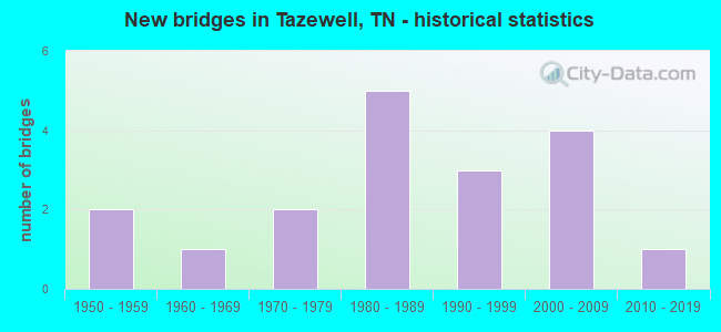
- New bridges - historical statistics
- 21950-1959
- 11960-1969
- 21970-1979
- 51980-1989
- 31990-1999
- 42000-2009
- 12010-2019


- Bridge Condition - Deck
- 40.0%Good
- 40.0%Satisfactory
- 20.0%Fair

- Bridge Condition - Superstructure
- 20.0%Very good
- 20.0%Good
- 60.0%Satisfactory

- Bridge Condition - Substructure
- 20.0%Very good
- 20.0%Good
- 60.0%Satisfactory

- Bridge Condition - Channel
- 12.5%Very good
- 43.8%Good
- 31.3%Satisfactory
- 12.5%Fair

- Bridge Condition - Culverts
- 8.3%Very good
- 50.0%Good
- 25.0%Satisfactory
- 16.7%Fair
Find on map >> Show street view
Structure Number: 13005061001, Location: IN TAZEWELL (Lat: 36.457450, Lng: -83.556283), Route carried "on" structure: State highway 345, Year Built: 1967, Status: Open, Structure Length: 0.87m (2.85ft), Average Daily Traffic: 2,517 (year 2020), Truck Traffic: 5%, Average Future Daily Traffic: 6,176 (year 2040), Design Load: HS 20, Features Intersected: RUSSELL CREEK
Minimum Vertical Clearance: 30+ m (98+ ft), Kilometerpoint: 0.813, Lanes on structure: 2, Owner: State Highway Agency, Approaching Roadway Width: 6.4m (21.0ft), Material/Design: Concrete continuous, Design/Construction: Culvert, Number Of Spans In Main Unit: 2, Length of Maximum Span: 4.0m (13.1ft)
Condition: Channel: Fair, Culverts: Fair, Operating Rating: 54.0 metric tons, Method Used To Determine Operating Rating: Field evaluation and documented engineering judgment, Inventory Rating: 32.4 metric tons, Method Used To Determine Inventory Rating: Field evaluation and documented engineering judgment, Structural Evaluation: Somewhat better than minimum adequacy, Waterway Adequacy: Better than present minimum criteria, Approach Roadway Alignment: Equal to present minimum criteria, Designated Inspection Frequency: Every 24 months, Inspection Date: May 2020
Find on map >> Show street view
Structure Number: 13024970001, Location: 4.5 M NW OF TAZEWELL (Lat: 36.510067, Lng: -83.605883), Route carried "on" structure: County highway 2497, Year Built: 1998, Status: Open, Structure Length: 0.99m (3.25ft), Average Daily Traffic: 1,016 (year 2020), Truck Traffic: 3%, Average Future Daily Traffic: 1,626 (year 2041), Design Load: HS 20, Features Intersected: BLAIR CREEK
Minimum Vertical Clearance: 30+ m (98+ ft), Kilometerpoint: 0.048, Lanes on structure: 2, Owner: County Highway Agency, Approaching Roadway Width: 8.8m (28.9ft), Material/Design: Concrete continuous, Design/Construction: Culvert, Number Of Spans In Main Unit: 3, Length of Maximum Span: 3.5m (11.5ft), Curb-To-Curb Width: 8.8m (28.9ft), Out-to-Out Width: 10.9m (35.8ft)
Condition: Channel: Good, Culverts: Good, Operating Rating: 65.7 metric tons, Method Used To Determine Operating Rating: Load Factor (LF), Inventory Rating: 32.4 metric tons, Method Used To Determine Inventory Rating: Load Factor (LF), Structural Evaluation: Better than present minimum criteria, Deck Geometry: Somewhat better than minimum adequacy, Waterway Adequacy: Better than present minimum criteria, Approach Roadway Alignment: Equal to present desirable criteria, Designated Inspection Frequency: Every 24 months, Inspection Date: June 2021, Deck Structure Type: Concrete Cast-file-Place, Wearing Surface/Protective System: Wearing Surface: Bituminous, Deck Protection: Epoxy Coated Reinforcing
Find on map >> Show street view
Structure Number: 13025540001, Location: 4.5 M NW OF TAZEWELL (Lat: 36.509750, Lng: -83.604083), Route carried "on" structure: County highway 2554, Year Built: 1970, Status: Open, Structure Length: 0.66m (2.17ft), Average Daily Traffic: 212 (year 2020), Truck Traffic: 3%, Average Future Daily Traffic: 339 (year 2041), Features Intersected: BLAIR CREEK
Minimum Vertical Clearance: 30+ m (98+ ft), Kilometerpoint: 0.032, Lanes on structure: 2, Owner: County Highway Agency, Approaching Roadway Width: 7.0m (23.0ft), Skew: 1 degrees, Material/Design: Concrete continuous, Design/Construction: Culvert, Number Of Spans In Main Unit: 2, Length of Maximum Span: 3.0m (9.8ft)
Condition: Channel: Good, Culverts: Satisfactory, Operating Rating: 89.1 metric tons, Method Used To Determine Operating Rating: Load Factor (LF), Inventory Rating: 32.4 metric tons, Method Used To Determine Inventory Rating: Load Factor (LF), Structural Evaluation: Equal to present minimum criteria, Waterway Adequacy: Better than present minimum criteria, Approach Roadway Alignment: Equal to present desirable criteria, Designated Inspection Frequency: Every 24 months, Inspection Date: June 2021
Find on map >> Show street view
Structure Number: 13025560001, Location: 5 M NE OF TAZEWELL (Lat: 36.500350, Lng: -83.505583), Route carried "on" structure: County highway 2556, Year Built: 1975, Status: Posted for load, Structure Length: 0.73m (2.40ft), Average Daily Traffic: 145 (year 2020), Truck Traffic: 2%, Average Future Daily Traffic: 232 (year 2041), Features Intersected: RUSSELL CREEK
Minimum Vertical Clearance: 30+ m (98+ ft), Kilometerpoint: 3.170, Lanes on structure: 1, Owner: County Highway Agency, Approaching Roadway Width: 4.6m (15.1ft), Skew: 1 degrees, Material/Design: Steel, Design/Construction: Stringer/Multi-beam, Number Of Spans In Main Unit: 1, Length of Maximum Span: 6.9m (22.6ft), Curb-To-Curb Width: 4.8m (15.7ft), Out-to-Out Width: 5.0m (16.4ft)
Condition: Deck: Satisfactory, Superstructure: Satisfactory, Substructure: Satisfactory, Channel: Good, Operating Rating: 33.3 metric tons, Method Used To Determine Operating Rating: Load Factor (LF), Inventory Rating: 16.2 metric tons, Method Used To Determine Inventory Rating: Load Factor (LF), Structural Evaluation: Somewhat better than minimum adequacy, Deck Geometry: High priority of corrective action, Waterway Adequacy: Equal to present minimum criteria, Approach Roadway Alignment: Equal to present minimum criteria, Bridge Posting: Required (Relationship of Operating Rating to Maximum Legal Load: 0.1 - 9.9% below), Length Of Structure Improvement: 0.73m (2.40ft), Designated Inspection Frequency: Every 24 months, Inspection Date: June 2021, Bridge Improvement Cost: $92,000, Roadway Improvement Cost: $10,000, Total Project Cost: $139,000 ( Estimate for 2021), Deck Structure Type: Corrugated Steel, Wearing Surface/Protective System: Wearing Surface: Bituminous
Find on map >> Show street view
Structure Number: 13025560003, Location: 5 M NE OF TAZEWELL (Lat: 36.502233, Lng: -83.506183), Route carried "on" structure: County highway 2556, Year Built: 1984, Status: Posted for load, Structure Length: 1.62m (5.31ft), Average Daily Traffic: 145 (year 2020), Truck Traffic: 2%, Average Future Daily Traffic: 232 (year 2042), Features Intersected: RUSSELL CREEK
Minimum Vertical Clearance: 30+ m (98+ ft), Kilometerpoint: 2.961, Lanes on structure: 2, Owner: County Highway Agency, Approaching Roadway Width: 6.1m (20.0ft), Material/Design: Steel, Design/Construction: Stringer/Multi-beam, Number Of Spans In Main Unit: 1, Length of Maximum Span: 15.2m (49.9ft), Curb-To-Curb Width: 6.5m (21.3ft), Out-to-Out Width: 6.7m (22.0ft)
Condition: Deck: Satisfactory, Superstructure: Satisfactory, Substructure: Satisfactory, Channel: Good, Operating Rating: 25.2 metric tons, Method Used To Determine Operating Rating: Allowable Stress (AS), Inventory Rating: 16.2 metric tons, Method Used To Determine Inventory Rating: Allowable Stress (AS), Structural Evaluation: Somewhat better than minimum adequacy, Deck Geometry: Meets minimum limits, Waterway Adequacy: Somewhat better than minimum adequacy, Approach Roadway Alignment: Equal to present minimum criteria, Bridge Posting: Required (Relationship of Operating Rating to Maximum Legal Load: 0.1 - 9.9% below), Length Of Structure Improvement: 2.31m (7.58ft), Designated Inspection Frequency: Every 24 months, Inspection Date: June 2021, Bridge Improvement Cost: $478,000, Roadway Improvement Cost: $48,000, Total Project Cost: $718,000 ( Estimate for 2022), Deck Structure Type: Corrugated Steel, Wearing Surface/Protective System: Wearing Surface: Bituminous
Find on map >> Show street view
Structure Number: 130A0020001, Location: HIGHLAND VIEW RD (Lat: 36.514183, Lng: -83.610200), Route carried "on" structure: County highway 2, Year Built: 1999, Status: Open, Structure Length: 1.07m (3.51ft), Average Daily Traffic: 80 (year 2022), Truck Traffic: 1%, Average Future Daily Traffic: 128 (year 2041), Design Load: HS 20, Features Intersected: BLAIR CREEK
Minimum Vertical Clearance: 30+ m (98+ ft), Kilometerpoint: 0.774, Lanes on structure: 2, Owner: County Highway Agency, Approaching Roadway Width: 6.1m (20.0ft), Skew: 3 degrees, Material/Design: Concrete continuous, Design/Construction: Culvert, Number Of Spans In Main Unit: 3, Length of Maximum Span: 3.4m (11.2ft), Curb-To-Curb Width: 6.1m (20.0ft), Out-to-Out Width: 8.8m (28.9ft)
Condition: Channel: Fair, Culverts: Good, Operating Rating: 85.5 metric tons, Method Used To Determine Operating Rating: Load Factor (LF), Inventory Rating: 32.4 metric tons, Method Used To Determine Inventory Rating: Load Factor (LF), Structural Evaluation: Better than present minimum criteria, Deck Geometry: Somewhat better than minimum adequacy, Waterway Adequacy: Meets minimum limits, Approach Roadway Alignment: Equal to present minimum criteria, Designated Inspection Frequency: Every 24 months, Inspection Date: June 2021, Deck Structure Type: Concrete Cast-file-Place, Wearing Surface/Protective System: Wearing Surface: Monolithic Concrete, Deck Protection: Epoxy Coated Reinforcing
Find on map >> Show street view
Structure Number: 130A2400001, Location: 4.5 M NE OF TAZEWELL (Lat: 36.464350, Lng: -83.487833), Route carried "on" structure: County highway 240, Year Built: 1984, Status: Open, Structure Length: 1.03m (3.38ft), Average Daily Traffic: 120 (year 2022), Truck Traffic: 4%, Average Future Daily Traffic: 192 (year 2041), Design Load: HS 20+Mod, Features Intersected: LITTLE SYCAMORE CREEK
Minimum Vertical Clearance: 30+ m (98+ ft), Kilometerpoint: 0.027, Lanes on structure: 2, Owner: County Highway Agency, Approaching Roadway Width: 6.4m (21.0ft), Skew: 1 degrees, Material/Design: Concrete continuous, Design/Construction: Culvert, Number Of Spans In Main Unit: 2, Length of Maximum Span: 4.7m (15.4ft), Curb-To-Curb Width: 6.7m (22.0ft), Out-to-Out Width: 8.2m (26.9ft)
Condition: Channel: Satisfactory, Culverts: Good, Operating Rating: 52.2 metric tons, Method Used To Determine Operating Rating: Load Factor (LF), Inventory Rating: 32.4 metric tons, Method Used To Determine Inventory Rating: Load Factor (LF), Structural Evaluation: Better than present minimum criteria, Deck Geometry: Meets minimum limits, Waterway Adequacy: Equal to present minimum criteria, Approach Roadway Alignment: Equal to present minimum criteria, Designated Inspection Frequency: Every 24 months, Inspection Date: June 2021, Deck Structure Type: Concrete Cast-file-Place, Wearing Surface/Protective System: Wearing Surface: Monolithic Concrete
Find on map >> Show street view
Structure Number: 130A2410001, Location: 3.5 M E OF TAZEWELL (Lat: 36.454767, Lng: -83.505233), Route carried "on" structure: County highway 241, Year Built: 2013, Status: Open, Structure Length: 1.04m (3.41ft), Average Daily Traffic: 150 (year 2022), Truck Traffic: 4%, Average Future Daily Traffic: 240 (year 2039), Design Load: HL 93, Features Intersected: LITTLE SYCAMORE CREEK
Minimum Vertical Clearance: 30+ m (98+ ft), Kilometerpoint: 0.080, Lanes on structure: 2, Owner: County Highway Agency, Approaching Roadway Width: 6.7m (22.0ft), Material/Design: Concrete continuous, Design/Construction: Culvert, Number Of Spans In Main Unit: 2, Length of Maximum Span: 4.9m (16.1ft), Curb-To-Curb Width: 6.7m (22.0ft), Out-to-Out Width: 8.4m (27.6ft)
Condition: Channel: Very good, Culverts: Very good, Operating Rating: 44.1 metric tons, Method Used To Determine Operating Rating: Assigned ratings based on Load and Resistance Factor Design (LRFD) reported by rating factor (RF) using HL93 loadings, Inventory Rating: 32.4 metric tons, Method Used To Determine Inventory Rating: Assigned ratings based on Load and Resistance Factor Design (LRFD) reported by rating factor (RF) using HL93 loadings, Structural Evaluation: Equal to present desirable criteria, Waterway Adequacy: Equal to present minimum criteria, Approach Roadway Alignment: Equal to present minimum criteria, Designated Inspection Frequency: Every 24 months, Inspection Date: June 2021, Deck Structure Type: Concrete Cast-file-Place, Wearing Surface/Protective System: Wearing Surface: Monolithic Concrete, Deck Protection: Epoxy Coated Reinforcing
Find on map >> Show street view
Structure Number: 130A2420001, Location: IN PLEASANT VIEW (Lat: 36.450383, Lng: -83.510717), Route carried "on" structure: County highway 242, Year Built: 1984, Status: Open, Structure Length: 0.92m (3.02ft), Average Daily Traffic: 120 (year 2022), Truck Traffic: 4%, Average Future Daily Traffic: 192 (year 2041), Features Intersected: LITTLE SYCAMORE CREEK
Minimum Vertical Clearance: 30+ m (98+ ft), Kilometerpoint: 1.323, Lanes on structure: 2, Owner: County Highway Agency, Approaching Roadway Width: 6.4m (21.0ft), Skew: 1 degrees, Material/Design: Steel, Design/Construction: Stringer/Multi-beam, Number Of Spans In Main Unit: 1, Length of Maximum Span: 8.0m (26.2ft), Curb-To-Curb Width: 7.3m (24.0ft), Out-to-Out Width: 7.5m (24.6ft)
Condition: Deck: Fair, Superstructure: Satisfactory, Substructure: Satisfactory, Channel: Good, Operating Rating: 36.0 metric tons, Method Used To Determine Operating Rating: Load Factor (LF), Inventory Rating: 26.1 metric tons, Method Used To Determine Inventory Rating: Load Factor (LF), Structural Evaluation: Equal to present minimum criteria, Deck Geometry: Somewhat better than minimum adequacy, Waterway Adequacy: Better than present minimum criteria, Approach Roadway Alignment: Equal to present minimum criteria, Designated Inspection Frequency: Every 24 months, Inspection Date: June 2021, Deck Structure Type: Corrugated Steel, Wearing Surface/Protective System: Wearing Surface: Bituminous
Find on map >> Show street view
Structure Number: 130A2430001, Location: 4 M E OF TAZEWELL (Lat: 36.453633, Lng: -83.507450), Route carried "on" structure: County highway 243, Year Built: 1995, Status: Posted for load, Structure Length: 0.99m (3.25ft), Average Daily Traffic: 70 (year 2022), Truck Traffic: 4%, Average Future Daily Traffic: 112 (year 2039), Design Load: HS 20, Features Intersected: LITTLE SYCAMORE CREEK
Minimum Vertical Clearance: 30+ m (98+ ft), Kilometerpoint: 0.016, Lanes on structure: 2, Owner: County Highway Agency, Approaching Roadway Width: 7.3m (24.0ft), Material/Design: Concrete continuous, Design/Construction: Culvert, Number Of Spans In Main Unit: 2, Length of Maximum Span: 4.6m (15.1ft), Curb-To-Curb Width: 8.1m (26.6ft), Out-to-Out Width: 9.6m (31.5ft)
Condition: Channel: Satisfactory, Culverts: Good, Operating Rating: 68.0 metric tons, Method Used To Determine Operating Rating: Load Factor (LF), Inventory Rating: 32.4 metric tons, Method Used To Determine Inventory Rating: Load Factor (LF), Structural Evaluation: Better than present minimum criteria, Deck Geometry: Equal to present minimum criteria, Waterway Adequacy: Equal to present minimum criteria, Approach Roadway Alignment: Equal to present minimum criteria, Designated Inspection Frequency: Every 24 months, Inspection Date: June 2021, Deck Structure Type: Concrete Cast-file-Place, Wearing Surface/Protective System: Wearing Surface: Monolithic Concrete, Deck Protection: Epoxy Coated Reinforcing
Find on map >> Show street view
Structure Number: 130A2450001, Location: 3 M E OF TAZEWELL (Lat: 36.444667, Lng: -83.519100), Route carried "on" structure: County highway 245, Year Built: 1986, Status: Open, Structure Length: 1.49m (4.89ft), Average Daily Traffic: 50 (year 2022), Truck Traffic: 4%, Average Future Daily Traffic: 80 (year 2041), Design Load: HS 20, Features Intersected: LITTLE SYCAMORE CREEK
Minimum Vertical Clearance: 30+ m (98+ ft), Kilometerpoint: 0.388, Lanes on structure: 2, Owner: County Highway Agency, Approaching Roadway Width: 6.7m (22.0ft), Material/Design: Concrete continuous, Design/Construction: Culvert, Number Of Spans In Main Unit: 3, Length of Maximum Span: 4.6m (15.1ft), Curb-To-Curb Width: 6.6m (21.7ft), Out-to-Out Width: 7.8m (25.6ft)
Condition: Channel: Satisfactory, Culverts: Satisfactory, Operating Rating: 58.5 metric tons, Method Used To Determine Operating Rating: Load Factor (LF), Inventory Rating: 32.4 metric tons, Method Used To Determine Inventory Rating: Load Factor (LF), Structural Evaluation: Equal to present minimum criteria, Deck Geometry: Somewhat better than minimum adequacy, Waterway Adequacy: Equal to present minimum criteria, Approach Roadway Alignment: Equal to present minimum criteria, Designated Inspection Frequency: Every 24 months, Inspection Date: June 2021, Deck Structure Type: Concrete Cast-file-Place, Wearing Surface/Protective System: Wearing Surface: Monolithic Concrete
Find on map >> Show street view
Structure Number: 13S23520003, Location: 2 M NW OF US25E-SR33 JCT. (Lat: 36.435683, Lng: -83.522550), Route carried "on" structure: County highway 1332, Year Built: 1985, Status: Open, Structure Length: 1.37m (4.49ft), Average Daily Traffic: 905 (year 2020), Truck Traffic: 3%, Average Future Daily Traffic: 1,448 (year 2042), Design Load: HS 20+Mod, Features Intersected: LITTLE SYCAMORE CREEK
Minimum Vertical Clearance: 30+ m (98+ ft), Kilometerpoint: 19.473, Lanes on structure: 2, Owner: County Highway Agency, Approaching Roadway Width: 7.9m (25.9ft), Skew: 3 degrees, Material/Design: Concrete continuous, Design/Construction: Culvert, Number Of Spans In Main Unit: 3, Length of Maximum Span: 4.3m (14.1ft), Curb-To-Curb Width: 8.5m (27.9ft), Out-to-Out Width: 9.5m (31.2ft)
Condition: Channel: Satisfactory, Culverts: Fair, Operating Rating: 89.1 metric tons, Method Used To Determine Operating Rating: Load Factor (LF), Inventory Rating: 32.4 metric tons, Method Used To Determine Inventory Rating: Load Factor (LF), Structural Evaluation: Somewhat better than minimum adequacy, Deck Geometry: Somewhat better than minimum adequacy, Waterway Adequacy: Equal to present minimum criteria, Approach Roadway Alignment: Equal to present minimum criteria, Length Of Structure Improvement: 1.37m (4.49ft), Designated Inspection Frequency: Every 24 months, Inspection Date: June 2021, Bridge Improvement Cost: $220,000, Roadway Improvement Cost: $23,000, Total Project Cost: $331,000 ( Estimate for 2022), Deck Structure Type: Concrete Cast-file-Place, Wearing Surface/Protective System: Wearing Surface: Bituminous
Find on map >> Show street view
Structure Number: 13SR0320007, Location: IN SPRING DALE (Lat: 36.423600, Lng: -83.523183), Route carried "on" structure: US 25, Year Built: 2005, Status: Open, Structure Length: 6.77m (22.21ft), Average Daily Traffic: 8,723 (year 2020), Truck Traffic: 11%, Average Future Daily Traffic: 14,368 (year 2040), Design Load: HS 20, Features Intersected: LITTLE SYCAMORE CREEK, Facility Carried by Structure: FAP 32
Minimum Vertical Clearance: 30+ m (98+ ft), Kilometerpoint: 7.097, Lanes on structure: 5, Base Highway Network: Yes, Owner: State Highway Agency, Approaching Roadway Width: 26.8m (87.9ft), Skew: 1 degrees, Material/Design: Prestressed concrete continuous, Design/Construction: Stringer/Multi-beam, Number Of Spans In Main Unit: 3, Length of Maximum Span: 22.7m (74.5ft), Curb-To-Curb Width: 25.6m (84.0ft), Out-to-Out Width: 26.8m (87.9ft)
Condition: Deck: Good, Superstructure: Good, Substructure: Very good, Channel: Good, Operating Rating: 68.4 metric tons, Method Used To Determine Operating Rating: Load Factor (LF), Inventory Rating: 32.4 metric tons, Method Used To Determine Inventory Rating: Load Factor (LF), Structural Evaluation: Better than present minimum criteria, Deck Geometry: Superior to present desirable criteria, Waterway Adequacy: Equal to present desirable criteria, Approach Roadway Alignment: Equal to present desirable criteria, Designated Inspection Frequency: Every 24 months, Inspection Date: June 2020, Deck Structure Type: Concrete Cast-file-Place, Wearing Surface/Protective System: Wearing Surface: Monolithic Concrete, Deck Protection: Epoxy Coated Reinforcing
Find on map >> Show street view
Structure Number: 13SR0320009, Location: IN TAZEWELL (Lat: 36.451000, Lng: -83.568417), Route carried "on" structure: City street 5484, Year Built: 1959, Status: Open, Structure Length: 1.76m (5.77ft), Average Daily Traffic: 3,810 (year 2020), Truck Traffic: 3%, Average Future Daily Traffic: 6,096 (year 2041), Design Load: HS 20, Features Intersected: RUSSELL CREEK, Facility Carried by Structure: NFA A756
Minimum Vertical Clearance: 30+ m (98+ ft), Kilometerpoint: 0.451, Lanes on structure: 2, Owner: City or Municipal Highway Agency, Approaching Roadway Width: 10.1m (33.1ft), Skew: 4 degrees, Material/Design: Concrete continuous, Design/Construction: Culvert, Number Of Spans In Main Unit: 3, Length of Maximum Span: 5.4m (17.7ft)
Condition: Channel: Satisfactory, Culverts: Satisfactory, Operating Rating: 45.0 metric tons, Method Used To Determine Operating Rating: Load Factor (LF), Inventory Rating: 26.1 metric tons, Method Used To Determine Inventory Rating: Load Factor (LF), Structural Evaluation: Equal to present minimum criteria, Waterway Adequacy: Equal to present minimum criteria, Approach Roadway Alignment: Equal to present desirable criteria, Length Of Structure Improvement: 1.76m (5.77ft), Designated Inspection Frequency: Every 24 months, Inspection Date: June 2021, Bridge Improvement Cost: $350,000, Roadway Improvement Cost: $36,000, Total Project Cost: $526,000 ( Estimate for 2021)
Find on map >> Show street view
Structure Number: 13SR0320011, Location: .4 M SE OF BACCHUS (Lat: 36.509783, Lng: -83.604617), Route carried "on" structure: US 25, Year Built: 1959, Status: Open, Structure Length: 1.55m (5.09ft), Average Daily Traffic: 15,824 (year 2020), Truck Traffic: 11%, Average Future Daily Traffic: 26,992 (year 2040), Design Load: HS 20, Features Intersected: BLAIR CREEK, Facility Carried by Structure: FAP 32
Minimum Vertical Clearance: 30+ m (98+ ft), Kilometerpoint: 21.276, Lanes on structure: 5, Base Highway Network: Yes, Owner: State Highway Agency, Approaching Roadway Width: 24.7m (81.0ft), Skew: 5 degrees, Material/Design: Concrete continuous, Design/Construction: Culvert, Number Of Spans In Main Unit: 3, Length of Maximum Span: 4.7m (15.4ft)
Condition: Channel: Good, Culverts: Good, Operating Rating: 61.2 metric tons, Method Used To Determine Operating Rating: Load Factor (LF), Inventory Rating: 32.4 metric tons, Method Used To Determine Inventory Rating: Load Factor (LF), Structural Evaluation: Better than present minimum criteria, Waterway Adequacy: Equal to present minimum criteria, Approach Roadway Alignment: Equal to present desirable criteria, Length Of Structure Improvement: 1.55m (5.09ft), Designated Inspection Frequency: Every 24 months, Inspection Date: June 2020, Bridge Improvement Cost: $540,000, Roadway Improvement Cost: $55,000, Total Project Cost: $811,000 ( Estimate for 2020)
Find on map >> Show street view
Structure Number: 13SR0320019, Location: .4 M SE OF BACCHUS (Lat: 36.455433, Lng: -83.565750), Route carried "on" structure: US 25, Year Built: 2001, Status: Open, Structure Length: 1.24m (4.07ft), Average Daily Traffic: 6,429 (year 2020), Truck Traffic: 11%, Average Future Daily Traffic: 12,240 (year 2040), Design Load: HS 20, Features Intersected: RUSSELL CREEK, Facility Carried by Structure: FAP 32
Minimum Vertical Clearance: 30+ m (98+ ft), Kilometerpoint: 14.130, Lanes on structure: 5, Base Highway Network: Yes, Owner: State Highway Agency, Approaching Roadway Width: 24.4m (80.1ft), Skew: 1 degrees, Material/Design: Concrete continuous, Design/Construction: Culvert, Number Of Spans In Main Unit: 3, Length of Maximum Span: 3.7m (12.1ft)
Condition: Channel: Very good, Culverts: Good, Operating Rating: 54.0 metric tons, Method Used To Determine Operating Rating: Field evaluation and documented engineering judgment, Inventory Rating: 32.4 metric tons, Method Used To Determine Inventory Rating: Field evaluation and documented engineering judgment, Structural Evaluation: Better than present minimum criteria, Waterway Adequacy: Better than present minimum criteria, Approach Roadway Alignment: Equal to present desirable criteria, Length Of Structure Improvement: 1.24m (4.07ft), Designated Inspection Frequency: Every 24 months, Inspection Date: June 2020, Bridge Improvement Cost: $438,000, Roadway Improvement Cost: $44,000, Total Project Cost: $658,000 ( Estimate for 2020)
Find on map >> Show street view
Structure Number: 13SR0320025, Location: DUE WEST OF SPRINGDALE (Lat: 36.429017, Lng: -83.557383), Route carried "on" structure: State highway 32, Year Built: 2005, Status: Open, Structure Length: 10.66m (34.97ft), Average Daily Traffic: 9,531 (year 2020), Truck Traffic: 11%, Average Future Daily Traffic: 17,616 (year 2040), Design Load: HS 20+Mod, Features Intersected: OLD SR032
Minimum Vertical Clearance: 30+ m (98+ ft), Kilometerpoint: 10.638, Lanes on structure: 4, Lanes under structure: 2, Base Highway Network: Yes, Owner: State Highway Agency, Approaching Roadway Width: 26.8m (87.9ft), Skew: 4 degrees, Material/Design: Prestressed concrete continuous, Design/Construction: Stringer/Multi-beam, Number Of Spans In Main Unit: 3, Length of Maximum Span: 42.0m (137.8ft), Curb-To-Curb Width: 26.2m (86.0ft), Out-to-Out Width: 26.8m (87.9ft)
Condition: Deck: Good, Superstructure: Very good, Substructure: Good, Operating Rating: 42.1 metric tons, Method Used To Determine Operating Rating: Load and Resistance Factor Rating (LRFR) rating reported by rating factor(RF) method using HL-93 loadings, Inventory Rating: 32.4 metric tons, Method Used To Determine Inventory Rating: Load and Resistance Factor Rating (LRFR) rating reported by rating factor(RF) method using HL-93 loadings, Structural Evaluation: Better than present minimum criteria, Deck Geometry: Superior to present desirable criteria, Underclear: Superior to present desirable criteria, Approach Roadway Alignment: Equal to present desirable criteria, Designated Inspection Frequency: Every 24 months, Inspection Date: June 2020, Deck Structure Type: Concrete Cast-file-Place, Wearing Surface/Protective System: Wearing Surface: Monolithic Concrete, Deck Protection: Epoxy Coated Reinforcing
Find on map >> Show street view
Structure Number: 13SR0320025, Location: DUE WEST OF SPRINGDALE (Lat: 36.429017, Lng: -83.557383), Route carried "under" structure: County highway A286, Year Built: 2005, Structure Length: 0. m, Average Daily Traffic: 7,250 (year 2022), Truck Traffic: 2%, Features Intersected: OLD SR032, Facility Carried by Structure: SR032
Minimum Vertical Clearance: 6.10m (20.01ft), Kilometerpoint: 2.569, Lanes on structure: 4, Lanes under structure: 2, Material/Design: Prestressed concrete continuous, Design/Construction: Stringer/Multi-beam, Length of Maximum Span: 42.0m (137.8ft)