Bridge Statistics for Teaneck, New Jersey (NJ)
Condition, Traffic, Stress, Structural Evaluation, Project Costs
- National Bridge Inventory (NBI) Statistics
- 47Number of bridges
- 495ft / 151mTotal length
- $78,342,000Total costs
- 2,463,187Total average daily traffic
- 163,981Total average daily truck traffic
- National Bridge Inventory (NBI) Registered Bridges for Teaneck
- No street view available for this location
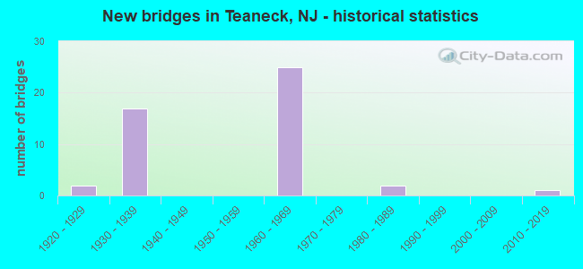
- New bridges - historical statistics
- 21920-1929
- 171930-1939
- 251960-1969
- 21980-1989
- 12010-2019
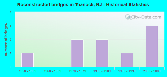
- Reconstructed bridges - Historical Statistics
- 11950-1959
- 01960-1969
- 21970-1979
- 21980-1989
- 11990-1999
- 32000-2009
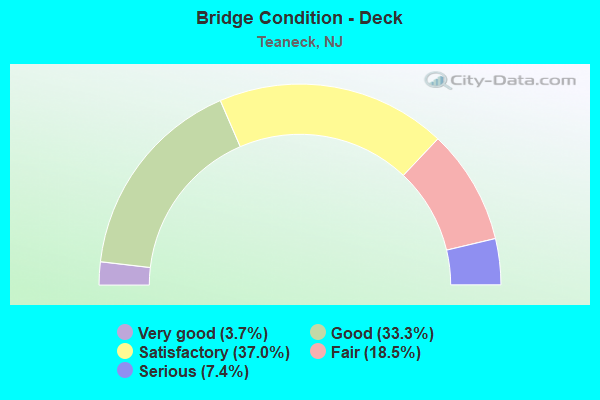
- Bridge Condition - Deck
- 3.7%Very good
- 33.3%Good
- 37.0%Satisfactory
- 18.5%Fair
- 7.4%Serious
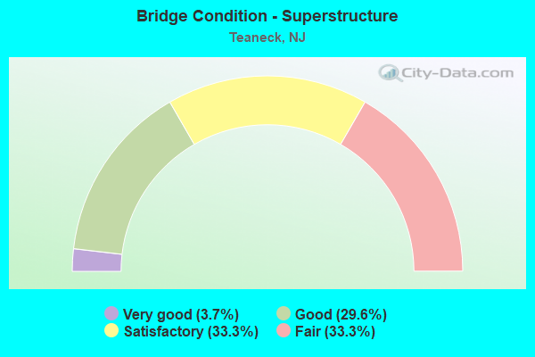
- Bridge Condition - Superstructure
- 3.7%Very good
- 29.6%Good
- 33.3%Satisfactory
- 33.3%Fair
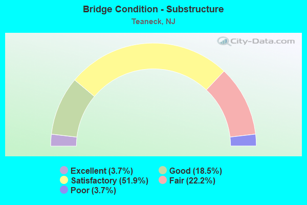
- Bridge Condition - Substructure
- 3.7%Excellent
- 18.5%Good
- 51.9%Satisfactory
- 22.2%Fair
- 3.7%Poor
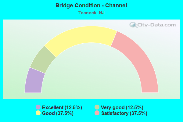
- Bridge Condition - Channel
- 12.5%Excellent
- 12.5%Very good
- 37.5%Good
- 37.5%Satisfactory
Find on map >> Show street view
Structure Number: 20060A, Location: 1.79 mi West of US 1 (Lat: 40.871969, Lng: -74.007919), Route carried "on" structure: County highway 56III, Year Built: 1963, Status: Open, Structure Length: 1.89m (6.20ft), Average Daily Traffic: 12,825 (year 2020), Truck Traffic: 4%, Average Future Daily Traffic: 15,390 (year 2040), Design Load: HS 20, Features Intersected: TEANECK CREEK, Facility Carried by Structure: Degraw Ave WB
Minimum Vertical Clearance: 30+ m (98+ ft), Kilometerpoint: 3.251, Lanes on structure: 3, Owner: County Highway Agency, Approaching Roadway Width: 12.2m (40.0ft), Material/Design: Prestressed concrete, Design/Construction: Stringer/Multi-beam, Number Of Spans In Main Unit: 1, Length of Maximum Span: 17.4m (57.1ft), Curb or Sidewalk Widths: Left: 1.8m (5.9ft), Right: 1.8m (5.9ft), Curb-To-Curb Width: 12.2m (40.0ft), Out-to-Out Width: 16.6m (54.5ft)
Condition: Deck: Satisfactory, Superstructure: Good, Substructure: Good, Channel: Good, Operating Rating: 53.5 metric tons, Method Used To Determine Operating Rating: Load Factor (LF), Inventory Rating: 31.8 metric tons, Method Used To Determine Inventory Rating: Load Factor (LF), Structural Evaluation: Better than present minimum criteria, Deck Geometry: Meets minimum limits, Waterway Adequacy: Equal to present desirable criteria, Approach Roadway Alignment: Equal to present minimum criteria, Designated Inspection Frequency: Every 24 months, Inspection Date: April 2020, Deck Structure Type: Concrete Cast-file-Place, Wearing Surface/Protective System: Wearing Surface: Monolithic Concrete
Find on map >> Show street view
Structure Number: 20060B, Location: 1.79 mi West of US 1 (Lat: 40.871800, Lng: -74.008319), Route carried "on" structure: County highway 56III, Year Built: 1984, Status: Open, Structure Length: 1.89m (6.20ft), Average Daily Traffic: 12,825 (year 2020), Truck Traffic: 4%, Average Future Daily Traffic: 15,390 (year 2040), Design Load: HS 20+Mod, Features Intersected: TEANECK CREEK, Facility Carried by Structure: Degraw Ave EB
Minimum Vertical Clearance: 30+ m (98+ ft), Kilometerpoint: 3.251, Lanes on structure: 4, Owner: County Highway Agency, Approaching Roadway Width: 15.2m (49.9ft), Material/Design: Prestressed concrete, Design/Construction: Stringer/Multi-beam, Number Of Spans In Main Unit: 1, Length of Maximum Span: 17.4m (57.1ft), Curb or Sidewalk Widths: Left: 0.6m (2.0ft), Right: 1.8m (5.9ft), Curb-To-Curb Width: 15.2m (49.9ft), Out-to-Out Width: 18.4m (60.4ft)
Condition: Deck: Good, Superstructure: Very good, Substructure: Good, Channel: Very good, Operating Rating: 50.8 metric tons, Method Used To Determine Operating Rating: Load Factor (LF), Inventory Rating: 29.9 metric tons, Method Used To Determine Inventory Rating: Load Factor (LF), Structural Evaluation: Better than present minimum criteria, Deck Geometry: High priority of corrective action, Waterway Adequacy: Equal to present desirable criteria, Approach Roadway Alignment: Equal to present desirable criteria, Designated Inspection Frequency: Every 24 months, Inspection Date: April 2020, Deck Structure Type: Concrete Cast-file-Place, Wearing Surface/Protective System: Wearing Surface: Bituminous
Find on map >> Show street view
Structure Number: 206167, Location: 0.25 MI EAST OF HACKEN.R. (Lat: 40.899531, Lng: -74.026869), Route carried "on" structure: State highway 4, Year Built: 1931, Status: Open, Structure Length: 1.71m (5.61ft), Average Daily Traffic: 89,744 (year 2020), Truck Traffic: 5%, Average Future Daily Traffic: 107,693 (year 2040), Design Load: H 20, Features Intersected: RIVER ROAD (CR 41)
Minimum Vertical Clearance: 30+ m (98+ ft), Kilometerpoint: 10.026, Lanes on structure: 6, Lanes under structure: 4, Base Highway Network: Yes, Owner: State Highway Agency, Approaching Roadway Width: 23.8m (78.1ft), Skew: 30 degrees, Material/Design: Steel, Design/Construction: Stringer/Multi-beam, Number Of Spans In Main Unit: 1, Length of Maximum Span: 16.2m (53.1ft), Curb or Sidewalk Widths: Left: 1.5m (4.9ft), Right: 1.5m (4.9ft), Curb-To-Curb Width: 20.7m (67.9ft), Out-to-Out Width: 25.8m (84.6ft)
Condition: Deck: Fair, Superstructure: Satisfactory, Substructure: Fair, Operating Rating: 59.9 metric tons, Method Used To Determine Operating Rating: Load Factor (LF), Inventory Rating: 35.4 metric tons, Method Used To Determine Inventory Rating: Load Factor (LF), Structural Evaluation: Somewhat better than minimum adequacy, Deck Geometry: High priority of replacement, Underclear: High priority of replacement, Approach Roadway Alignment: Equal to present desirable criteria, Length Of Structure Improvement: 2.44m (8.01ft), Designated Inspection Frequency: Every 24 months, Inspection Date: May 2020, Bridge Improvement Cost: $3,948,000, Roadway Improvement Cost: $1,421,000, Total Project Cost: $7,712,000 ( Estimate for 2020), Deck Structure Type: Concrete Cast-file-Place, Wearing Surface/Protective System: Wearing Surface: Bituminous
Find on map >> Show street view
Structure Number: 206168, Location: 3.4 MI EAST OF NJ 17 (Lat: 40.895450, Lng: -74.018250), Route carried "on" structure: City street , Year Built: 1931, Status: Open, Structure Length: 3.17m (10.40ft), Average Daily Traffic: 2,348 (year 2020), Truck Traffic: 3%, Average Future Daily Traffic: 2,812 (year 2040), Design Load: HS 20, Features Intersected: NJ 4, Facility Carried by Structure: GARRISON AVE.
Minimum Vertical Clearance: 30+ m (98+ ft), Kilometerpoint: 0.000, Lanes on structure: 2, Lanes under structure: 5, Owner: State Highway Agency, Approaching Roadway Width: 11.0m (36.1ft), Material/Design: Steel continuous, Design/Construction: Girder and Floorbeam System, Number Of Spans In Main Unit: 3, Length of Maximum Span: 23.8m (78.1ft), Curb or Sidewalk Widths: Left: 1.7m (5.6ft), Right: 1.7m (5.6ft), Curb-To-Curb Width: 11.0m (36.1ft), Out-to-Out Width: 11.3m (37.1ft)
Condition: Deck: Fair, Superstructure: Fair, Substructure: Fair, Operating Rating: 39.0 metric tons, Method Used To Determine Operating Rating: Load Factor (LF), Inventory Rating: 23.6 metric tons, Method Used To Determine Inventory Rating: Load Factor (LF), Structural Evaluation: Somewhat better than minimum adequacy, Deck Geometry: Somewhat better than minimum adequacy, Underclear: High priority of corrective action, Approach Roadway Alignment: Equal to present minimum criteria, Length Of Structure Improvement: 3.96m (12.99ft), Designated Inspection Frequency: Every 24 months, Critical Feature Inspection Frequency: Every 24 months, Inspection Date: March 2020, Critical Feature Inspection Date: March 2020, Bridge Improvement Cost: $2,516,000, Roadway Improvement Cost: $252,000, Total Project Cost: $3,918,000 ( Estimate for 2020), Deck Structure Type: Concrete Cast-file-Place, Wearing Surface/Protective System: Wearing Surface: Bituminous
Find on map >> Show street view
Structure Number: 206169, Location: 3.65 MI EAST OF RT 17 (Lat: 40.894331, Lng: -74.015019), Route carried "on" structure: State highway 4, Year Built: 1931, Year Reconstructed: 1964, Status: Open, Structure Length: 15.09m (49.51ft), Average Daily Traffic: 87,130 (year 2020), Truck Traffic: 5%, Average Future Daily Traffic: 105,960 (year 2040), Features Intersected: PALSD AV,WNDSR RD&CSX RR
Minimum Vertical Clearance: 30+ m (98+ ft), Kilometerpoint: 11.265, Lanes on structure: 5, Lanes under structure: 4, Base Highway Network: Yes, Owner: State Highway Agency, Approaching Roadway Width: 20.4m (66.9ft), Skew: 30 degrees, Material/Design: Steel, Design/Construction: Stringer/Multi-beam, Number Of Spans In Main Unit: 8, Length of Maximum Span: 21.3m (69.9ft), Curb or Sidewalk Widths: Left: 1.7m (5.6ft), Right: 1.7m (5.6ft), Curb-To-Curb Width: 19.2m (63.0ft), Out-to-Out Width: 24.0m (78.7ft)
Condition: Deck: Serious, Superstructure: Fair, Substructure: Fair, Operating Rating: 49.0 metric tons, Method Used To Determine Operating Rating: Load Factor (LF), Inventory Rating: 29.0 metric tons, Method Used To Determine Inventory Rating: Load Factor (LF), Structural Evaluation: Somewhat better than minimum adequacy, Deck Geometry: Meets minimum limits, Underclear: Meets minimum limits, Approach Roadway Alignment: Equal to present desirable criteria, Length Of Structure Improvement: 15.85m (52.00ft), Designated Inspection Frequency: Every 24 months, Inspection Date: May 2020, Bridge Improvement Cost: $16,848,000, Roadway Improvement Cost: $650,000, Total Project Cost: $32,040,000 ( Estimate for 2020), Deck Structure Type: Concrete Cast-file-Place, Wearing Surface/Protective System: Wearing Surface: Bituminous
Find on map >> Show street view
Structure Number: 206171, Location: 3.8 MI EAST OF NJ 17 (Lat: 40.893111, Lng: -74.011650), Route carried "on" structure: State highway 4, Year Built: 1931, Status: Open, Structure Length: 1.71m (5.61ft), Average Daily Traffic: 89,744 (year 2020), Truck Traffic: 5%, Average Future Daily Traffic: 107,693 (year 2040), Design Load: H 20, Features Intersected: QUEEN ANNE ROAD
Minimum Vertical Clearance: 30+ m (98+ ft), Kilometerpoint: 11.491, Lanes on structure: 5, Lanes under structure: 2, Base Highway Network: Yes, Owner: State Highway Agency, Approaching Roadway Width: 19.2m (63.0ft), Skew: 30 degrees, Material/Design: Steel, Design/Construction: Stringer/Multi-beam, Number Of Spans In Main Unit: 1, Length of Maximum Span: 16.5m (54.1ft), Curb or Sidewalk Widths: Left: 1.5m (4.9ft), Right: 1.5m (4.9ft), Curb-To-Curb Width: 19.2m (63.0ft), Out-to-Out Width: 24.3m (79.7ft)
Condition: Deck: Fair, Superstructure: Satisfactory, Substructure: Satisfactory, Operating Rating: 43.5 metric tons, Method Used To Determine Operating Rating: Load Factor (LF), Inventory Rating: 26.3 metric tons, Method Used To Determine Inventory Rating: Load Factor (LF), Structural Evaluation: Equal to present minimum criteria, Deck Geometry: High priority of replacement, Underclear: Meets minimum limits, Approach Roadway Alignment: Equal to present desirable criteria, Length Of Structure Improvement: 1.71m (5.61ft), Designated Inspection Frequency: Every 24 months, Inspection Date: March 2020, Bridge Improvement Cost: $229,000, Roadway Improvement Cost: $23,000, Total Project Cost: $422,000 ( Estimate for 2020), Deck Structure Type: Concrete Cast-file-Place, Wearing Surface/Protective System: Wearing Surface: Bituminous
Find on map >> Show street view
Structure Number: 206172, Location: 4.0 MI E. OF 17-4 JCT (Lat: 40.891869, Lng: -74.007961), Route carried "on" structure: City street , Year Built: 1931, Year Reconstructed: 2006, Status: Open, Structure Length: 2.83m (9.28ft), Average Daily Traffic: 2,750 (year 2021), Truck Traffic: 1%, Average Future Daily Traffic: 3,300 (year 2041), Design Load: HL 93, Features Intersected: NJ 4, Facility Carried by Structure: MARGARET STREET
Minimum Vertical Clearance: 30+ m (98+ ft), Kilometerpoint: 0.000, Lanes on structure: 2, Lanes under structure: 5, Owner: State Highway Agency, Approaching Roadway Width: 9.0m (29.5ft), Material/Design: Steel, Design/Construction: Girder and Floorbeam System, Number Of Spans In Main Unit: 1, Length of Maximum Span: 27.1m (88.9ft), Curb or Sidewalk Widths: Left: 1.8m (5.9ft), Right: 1.8m (5.9ft), Curb-To-Curb Width: 9.0m (29.5ft), Out-to-Out Width: 9.6m (31.5ft)
Condition: Deck: Good, Superstructure: Satisfactory, Substructure: Fair, Operating Rating: 50.2 metric tons, Method Used To Determine Operating Rating: Load and Resistance Factor Rating (LRFR) rating reported by rating factor(RF) method using HL-93 loadings, Inventory Rating: 38.6 metric tons, Method Used To Determine Inventory Rating: Load and Resistance Factor Rating (LRFR) rating reported by rating factor(RF) method using HL-93 loadings, Structural Evaluation: Somewhat better than minimum adequacy, Deck Geometry: Meets minimum limits, Underclear: High priority of replacement, Approach Roadway Alignment: Better than present minimum criteria, Length Of Structure Improvement: 3.69m (12.11ft), Designated Inspection Frequency: Every 24 months, Critical Feature Inspection Frequency: Every 24 months, Inspection Date: August 2021, Critical Feature Inspection Date: August 2021, Bridge Improvement Cost: $2,369,000, Roadway Improvement Cost: $50,000, Total Project Cost: $3,362,000 ( Estimate for 2021), Deck Structure Type: Concrete Cast-file-Place, Wearing Surface/Protective System: Deck Protection: Epoxy Coated Reinforcing
Find on map >> Show street view
Structure Number: 206173, Location: 4.0MI EAST OF NJ 17 (Lat: 40.890450, Lng: -74.003639), Route carried "on" structure: State highway 4, Year Built: 1931, Status: Open, Structure Length: 1.74m (5.71ft), Average Daily Traffic: 93,770 (year 2020), Truck Traffic: 5%, Average Future Daily Traffic: 112,524 (year 2040), Design Load: H 20, Features Intersected: TEANECK ROAD
Minimum Vertical Clearance: 30+ m (98+ ft), Kilometerpoint: 12.215, Lanes on structure: 7, Lanes under structure: 2, Base Highway Network: Yes, Owner: State Highway Agency, Approaching Roadway Width: 31.1m (102.0ft), Skew: 30 degrees, Material/Design: Steel, Design/Construction: Stringer/Multi-beam, Number Of Spans In Main Unit: 1, Length of Maximum Span: 16.5m (54.1ft), Curb or Sidewalk Widths: Left: 2.0m (6.6ft), Right: 2.0m (6.6ft), Curb-To-Curb Width: 31.1m (102.0ft), Out-to-Out Width: 36.2m (118.8ft)
Condition: Deck: Serious, Superstructure: Fair, Substructure: Poor, Operating Rating: 59.9 metric tons, Method Used To Determine Operating Rating: Load Factor (LF), Inventory Rating: 36.3 metric tons, Method Used To Determine Inventory Rating: Load Factor (LF), Structural Evaluation: Meets minimum limits, Deck Geometry: Equal to present minimum criteria, Underclear: High priority of corrective action, Approach Roadway Alignment: Equal to present desirable criteria, Length Of Structure Improvement: 1.74m (5.71ft), Designated Inspection Frequency: Every 24 months, Inspection Date: March 2020, Bridge Improvement Cost: $1,558,000, Roadway Improvement Cost: $154,000, Total Project Cost: $1,968,000 ( Estimate for 2020), Deck Structure Type: Concrete Cast-file-Place, Wearing Surface/Protective System: Wearing Surface: Bituminous
Find on map >> Show street view
Structure Number: 206174, Location: 2.5 MI W OF I-95 JCT (Lat: 40.887769, Lng: -73.995039), Route carried "on" structure: State highway 4, Year Built: 1931, Status: Open, Structure Length: 1.46m (4.79ft), Average Daily Traffic: 93,770 (year 2020), Truck Traffic: 5%, Average Future Daily Traffic: 112,524 (year 2040), Design Load: H 20, Features Intersected: WEBSTER AVENUE
Minimum Vertical Clearance: 30+ m (98+ ft), Kilometerpoint: 13.003, Lanes on structure: 5, Lanes under structure: 2, Base Highway Network: Yes, Owner: State Highway Agency, Approaching Roadway Width: 20.7m (67.9ft), Skew: 31 degrees, Material/Design: Steel, Design/Construction: Stringer/Multi-beam, Number Of Spans In Main Unit: 1, Length of Maximum Span: 13.4m (44.0ft), Curb or Sidewalk Widths: Left: 1.9m (6.2ft), Right: 1.6m (5.2ft), Curb-To-Curb Width: 20.7m (67.9ft), Out-to-Out Width: 25.8m (84.6ft)
Condition: Deck: Fair, Superstructure: Fair, Substructure: Fair, Operating Rating: 39.9 metric tons, Method Used To Determine Operating Rating: Load Factor (LF), Inventory Rating: 23.6 metric tons, Method Used To Determine Inventory Rating: Load Factor (LF), Structural Evaluation: Somewhat better than minimum adequacy, Deck Geometry: Meets minimum limits, Underclear: Somewhat better than minimum adequacy, Approach Roadway Alignment: Better than present minimum criteria, Designated Inspection Frequency: Every 24 months, Inspection Date: April 2020, Deck Structure Type: Concrete Cast-file-Place, Wearing Surface/Protective System: Wearing Surface: Bituminous
Find on map >> Show street view
Structure Number: 206175, Location: 2 MILES WEST OF I-95 JCT (Lat: 40.886200, Lng: -73.992489), Route carried "on" structure: State highway 4, Year Built: 1931, Status: Open, Structure Length: 1.77m (5.81ft), Average Daily Traffic: 93,770 (year 2020), Truck Traffic: 5%, Average Future Daily Traffic: 112,524 (year 2040), Design Load: H 20, Features Intersected: PROP. LAFAYETTE AVE EXT.
Minimum Vertical Clearance: 30+ m (98+ ft), Kilometerpoint: 13.277, Lanes on structure: 5, Base Highway Network: Yes, Owner: State Highway Agency, Approaching Roadway Width: 24.7m (81.0ft), Skew: 31 degrees, Material/Design: Steel, Design/Construction: Stringer/Multi-beam, Number Of Spans In Main Unit: 1, Length of Maximum Span: 16.8m (55.1ft), Curb or Sidewalk Widths: Left: 1.8m (5.9ft), Right: 1.6m (5.2ft), Curb-To-Curb Width: 24.7m (81.0ft), Out-to-Out Width: 29.8m (97.8ft)
Condition: Deck: Satisfactory, Superstructure: Satisfactory, Substructure: Satisfactory, Operating Rating: 40.8 metric tons, Method Used To Determine Operating Rating: Load Factor (LF), Inventory Rating: 24.5 metric tons, Method Used To Determine Inventory Rating: Load Factor (LF), Structural Evaluation: Equal to present minimum criteria, Deck Geometry: Better than present minimum criteria, Approach Roadway Alignment: Equal to present desirable criteria, Designated Inspection Frequency: Every 24 months, Inspection Date: April 2020, Deck Structure Type: Concrete Cast-file-Place, Wearing Surface/Protective System: Wearing Surface: Bituminous
Find on map >> Show street view
Structure Number: 226167, Location: 0.5 MI W OF NJTPK JCT. (Lat: 40.865461, Lng: -74.020150), Route carried "on" structure: City street , Year Built: 1963, Year Reconstructed: 2004, Status: Open, Structure Length: 7.38m (24.21ft), Average Daily Traffic: 163 (year 2021), Truck Traffic: 1%, Average Future Daily Traffic: 196 (year 2041), Design Load: HL 93, Features Intersected: I-80, Facility Carried by Structure: PARK AVENUE
Minimum Vertical Clearance: 30+ m (98+ ft), Kilometerpoint: 0.000, Lanes on structure: 2, Lanes under structure: 11, Owner: State Highway Agency, Approaching Roadway Width: 9.1m (29.9ft), Material/Design: Steel, Design/Construction: Stringer/Multi-beam, Number Of Spans In Main Unit: 3, Length of Maximum Span: 28.0m (91.9ft), Curb or Sidewalk Widths: Left: 1.8m (5.9ft), Right: 1.8m (5.9ft), Curb-To-Curb Width: 9.1m (29.9ft), Out-to-Out Width: 13.4m (44.0ft)
Condition: Deck: Very good, Superstructure: Good, Substructure: Satisfactory, Operating Rating: 51.8 metric tons, Method Used To Determine Operating Rating: Load and Resistance Factor Rating (LRFR) rating reported by rating factor(RF) method using HL-93 loadings, Inventory Rating: 45.7 metric tons, Method Used To Determine Inventory Rating: Load and Resistance Factor Rating (LRFR) rating reported by rating factor(RF) method using HL-93 loadings, Structural Evaluation: Equal to present minimum criteria, Deck Geometry: Equal to present minimum criteria, Underclear: Meets minimum limits, Approach Roadway Alignment: Equal to present desirable criteria, Designated Inspection Frequency: Every 24 months, Inspection Date: June 2021, Deck Structure Type: Concrete Cast-file-Place, Wearing Surface/Protective System: Wearing Surface: Latex Concrete, Deck Protection: Epoxy Coated Reinforcing
Find on map >> Show street view
Structure Number: 226168, Location: 0.84 MI East of Intch 67 (Lat: 40.864700, Lng: -74.015731), Route carried "on" structure: County highway 39, Year Built: 1963, Year Reconstructed: 2005, Status: Open, Structure Length: 9.75m (31.99ft), Average Daily Traffic: 8,067 (year 2020), Truck Traffic: 4%, Average Future Daily Traffic: 9,843 (year 2040), Design Load: HS 20+Mod, Features Intersected: Route I-80
Minimum Vertical Clearance: 30+ m (98+ ft), Kilometerpoint: 2.575, Lanes on structure: 2, Lanes under structure: 14, Base Highway Network: Yes, Owner: State Highway Agency, Approaching Roadway Width: 14.0m (45.9ft), Material/Design: Steel, Design/Construction: Stringer/Multi-beam, Number Of Spans In Main Unit: 4, Length of Maximum Span: 27.4m (89.9ft), Curb or Sidewalk Widths: Left: 1.8m (5.9ft), Right: 1.8m (5.9ft), Curb-To-Curb Width: 14.0m (45.9ft), Out-to-Out Width: 18.4m (60.4ft)
Condition: Deck: Satisfactory, Superstructure: Good, Substructure: Satisfactory, Operating Rating: 65.3 metric tons, Method Used To Determine Operating Rating: Load Factor (LF), Inventory Rating: 39.0 metric tons, Method Used To Determine Inventory Rating: Load Factor (LF), Structural Evaluation: Equal to present minimum criteria, Deck Geometry: Superior to present desirable criteria, Underclear: High priority of corrective action, Approach Roadway Alignment: Equal to present desirable criteria, Length Of Structure Improvement: 9.75m (31.99ft), Designated Inspection Frequency: Every 24 months, Inspection Date: April 2020, Roadway Improvement Cost: $33,000, Total Project Cost: $38,000 ( Estimate for 2020), Deck Structure Type: Concrete Cast-file-Place, Wearing Surface/Protective System: Wearing Surface: Latex Concrete
Find on map >> Show street view
Structure Number: 229153, Location: 1.0 Mile North of RT US46 (Lat: 40.864200, Lng: -74.012981), Route carried "on" structure: Ramp Interstate 95, Year Built: 1964, Year Reconstructed: 2014, Status: Open, Structure Length: 4.97m (16.31ft), Average Daily Traffic: 6,610 (year 2020), Truck Traffic: 9%, Average Future Daily Traffic: 8,065 (year 2040), Design Load: HS 20+Mod, Features Intersected: I-80 EB LOCAL, Facility Carried by Structure: I-80 EB EXP. RAMP
Minimum Vertical Clearance: 30+ m (98+ ft), Kilometerpoint: 118.432, Lanes on structure: 1, Lanes under structure: 3, Owner: State Highway Agency, Approaching Roadway Width: 9.8m (32.2ft), Skew: 4 degrees, Material/Design: Steel, Design/Construction: Girder and Floorbeam System, Number Of Spans In Main Unit: 1, Length of Maximum Span: 46.3m (151.9ft), Curb-To-Curb Width: 9.8m (32.2ft), Out-to-Out Width: 10.8m (35.4ft)
Condition: Deck: Good, Superstructure: Good, Substructure: Good, Operating Rating: 56.2 metric tons, Method Used To Determine Operating Rating: Load Factor (LF), Inventory Rating: 33.6 metric tons, Method Used To Determine Inventory Rating: Load Factor (LF), Structural Evaluation: Better than present minimum criteria, Deck Geometry: Superior to present desirable criteria, Underclear: Meets minimum limits, Approach Roadway Alignment: Equal to present minimum criteria, Designated Inspection Frequency: Every 24 months, Critical Feature Inspection Frequency: Every 24 months, Inspection Date: October 2020, Critical Feature Inspection Date: October 2020, Deck Structure Type: Concrete Cast-file-Place, Wearing Surface/Protective System: Wearing Surface: Monolithic Concrete, Deck Protection: Epoxy Coated Reinforcing
Find on map >> Show street view
Structure Number: 229157, Location: 0.25 MILES S. OF CR 56 (Lat: 40.867739, Lng: -74.005669), Route carried "on" structure: Ramp Interstate 95, Year Built: 1963, Status: Open, Structure Length: 1.71m (5.61ft), Average Daily Traffic: 16,700 (year 2020), Truck Traffic: 9%, Average Future Daily Traffic: 20,040 (year 2040), Design Load: HS 20+Mod, Features Intersected: TEANECK CREEK
Minimum Vertical Clearance: 30+ m (98+ ft), Kilometerpoint: 119.043, Lanes on structure: 1, Owner: State Highway Agency, Approaching Roadway Width: 7.9m (25.9ft), Skew: 1 degrees, Material/Design: Prestressed concrete, Design/Construction: Stringer/Multi-beam, Number Of Spans In Main Unit: 1, Length of Maximum Span: 15.5m (50.9ft), Curb or Sidewalk Widths: Left: 1.1m (3.6ft), Right: 1.1m (3.6ft), Curb-To-Curb Width: 7.9m (25.9ft), Out-to-Out Width: 10.9m (35.8ft)
Condition: Deck: Satisfactory, Superstructure: Good, Substructure: Satisfactory, Channel: Good, Operating Rating: 39.9 metric tons, Method Used To Determine Operating Rating: Load Factor (LF), Inventory Rating: 23.6 metric tons, Method Used To Determine Inventory Rating: Load Factor (LF), Structural Evaluation: Somewhat better than minimum adequacy, Deck Geometry: Equal to present desirable criteria, Waterway Adequacy: Equal to present desirable criteria, Approach Roadway Alignment: Better than present minimum criteria, Designated Inspection Frequency: Every 24 months, Inspection Date: July 2020, Deck Structure Type: Concrete Cast-file-Place
Find on map >> Show street view
Structure Number: 250161, Location: 0.7 mi West of CR 39 (Lat: 40.888331, Lng: -74.019739), Route carried "on" structure: County highway 60, Year Built: 1980, Status: Open, Structure Length: 5.94m (19.49ft), Average Daily Traffic: 14,440 (year 2020), Truck Traffic: 4%, Average Future Daily Traffic: 17,620 (year 2040), Design Load: HS 20+Mod, Features Intersected: RIVER LINE (CSXT), Facility Carried by Structure: CEDAR LANE
Minimum Vertical Clearance: 30+ m (98+ ft), Kilometerpoint: 2.076, Lanes on structure: 4, Maintenance Responsibility: State Highway Agency, Approaching Roadway Width: 18.3m (60.0ft), Skew: 1 degrees, Material/Design: Steel, Design/Construction: Stringer/Multi-beam, Number Of Spans In Main Unit: 3, Length of Maximum Span: 24.1m (79.1ft), Curb or Sidewalk Widths: Left: 2.1m (6.9ft), Right: 2.1m (6.9ft), Curb-To-Curb Width: 18.3m (60.0ft), Out-to-Out Width: 23.2m (76.1ft)
Condition: Deck: Fair, Superstructure: Satisfactory, Substructure: Fair, Inventory Rating: 61.7 metric tons, Method Used To Determine Inventory Rating: Load Factor (LF), Structural Evaluation: Somewhat better than minimum adequacy, Deck Geometry: Somewhat better than minimum adequacy, Underclear: Better than present minimum criteria, Approach Roadway Alignment: Equal to present minimum criteria, Designated Inspection Frequency: Every 24 months, Inspection Date: November 2020, Deck Structure Type: Concrete Cast-file-Place, Wearing Surface/Protective System: Wearing Surface: Monolithic Concrete, Deck Protection: Epoxy Coated Reinforcing
Find on map >> Show street view
Structure Number: 250162, Location: 0.1 MI W OF PALISADE AVE (Lat: 40.892261, Lng: -74.016461), Route carried "on" structure: City street , Year Built: 1966, Status: Open, Structure Length: 4.69m (15.39ft), Average Daily Traffic: 3,460 (year 2021), Truck Traffic: 1%, Average Future Daily Traffic: 4,222 (year 2041), Design Load: HS 20+Mod, Features Intersected: RIVER LINE (CSXT), Facility Carried by Structure: GRAYSON PLACE
Minimum Vertical Clearance: 30+ m (98+ ft), Kilometerpoint: 0.000, Lanes on structure: 2, Maintenance Responsibility: State Highway Agency, Approaching Roadway Width: 7.9m (25.9ft), Skew: 2 degrees, Material/Design: Steel continuous, Design/Construction: Frame, Number Of Spans In Main Unit: 3, Length of Maximum Span: 22.3m (73.2ft), Curb or Sidewalk Widths: Left: 1.4m (4.6ft), Right: 1.4m (4.6ft), Curb-To-Curb Width: 7.9m (25.9ft), Out-to-Out Width: 8.7m (28.5ft)
Condition: Deck: Satisfactory, Superstructure: Fair, Substructure: Good, Inventory Rating: 77.1 metric tons, Method Used To Determine Inventory Rating: Load Factor (LF), Structural Evaluation: Somewhat better than minimum adequacy, Deck Geometry: High priority of corrective action, Underclear: Somewhat better than minimum adequacy, Approach Roadway Alignment: Somewhat better than minimum adequacy, Length Of Structure Improvement: 5.70m (18.70ft), Designated Inspection Frequency: Every 24 months, Critical Feature Inspection Frequency: Every 24 months, Inspection Date: September 2021, Critical Feature Inspection Date: September 2021, Bridge Improvement Cost: $3,389,000, Roadway Improvement Cost: $106,000, Total Project Cost: $6,806,000 ( Estimate for 2021), Deck Structure Type: Concrete Cast-file-Place, Wearing Surface/Protective System: Wearing Surface: Monolithic Concrete
Find on map >> Show street view
Structure Number: 250163, Location: 0.37 MI NW OF TEANECK RD. (Lat: 40.903661, Lng: -74.006081), Route carried "on" structure: City street , Year Built: 1926, Year Reconstructed: 1985, Status: Open, Structure Length: 6.74m (22.11ft), Average Daily Traffic: 8,087 (year 2021), Truck Traffic: 4%, Average Future Daily Traffic: 9,868 (year 2041), Design Load: HS 20+Mod, Features Intersected: RIVER LINE&PALISADES AVE, Facility Carried by Structure: STATE STREET
Minimum Vertical Clearance: 30+ m (98+ ft), Kilometerpoint: 0.225, Lanes on structure: 2, Lanes under structure: 2, Maintenance Responsibility: State Highway Agency, Approaching Roadway Width: 20.7m (67.9ft), Material/Design: Steel, Design/Construction: Girder and Floorbeam System, Number Of Spans In Main Unit: 4, Length of Maximum Span: 25.3m (83.0ft), Curb or Sidewalk Widths: Left: 1.8m (5.9ft), Right: 1.8m (5.9ft), Curb-To-Curb Width: 9.1m (29.9ft), Out-to-Out Width: 9.4m (30.8ft)
Condition: Deck: Satisfactory, Superstructure: Fair, Substructure: Satisfactory, Operating Rating: 59.0 metric tons, Method Used To Determine Operating Rating: Load Factor (LF), Inventory Rating: 35.4 metric tons, Method Used To Determine Inventory Rating: Load Factor (LF), Structural Evaluation: Somewhat better than minimum adequacy, Deck Geometry: Meets minimum limits, Underclear: Somewhat better than minimum adequacy, Approach Roadway Alignment: Equal to present minimum criteria, Designated Inspection Frequency: Every 24 months, Critical Feature Inspection Frequency: Every 24 months, Inspection Date: September 2021, Critical Feature Inspection Date: September 2021, Deck Structure Type: Concrete Cast-file-Place, Wearing Surface/Protective System: Wearing Surface: Latex Concrete
Find on map >> Show street view
Structure Number: 253003, Location: 0.02 Mi S. of Fort Lee Rd (Lat: 40.866669, Lng: -74.000031), Route carried "on" structure: City street , Year Built: 2013, Status: Open, Structure Length: 10.67m (35.01ft), Average Daily Traffic: 1,590 (year 2020), Truck Traffic: 1%, Average Future Daily Traffic: 1,910 (year 2040), Design Load: HS 20+Mod, Features Intersected: Overpeck Creek, Facility Carried by Structure: Park Drive
Minimum Vertical Clearance: 4.43m (14.53ft), Kilometerpoint: 0.000, Lanes on structure: 2, Owner: Local Park, Forest, or Reservation Agency, Approaching Roadway Width: 9.1m (29.9ft), Material/Design: Wood or Timber, Design/Construction: Arch - Thru, Number Of Spans In Main Unit: 2, Number Of Approach Spans: 1, Length of Maximum Span: 42.7m (140.1ft), Curb or Sidewalk Widths: Left: 0.0m, Right: 3.0m (9.8ft), Curb-To-Curb Width: 9.1m (29.9ft), Out-to-Out Width: 10.4m (34.1ft)
Condition: Deck: Good, Superstructure: Good, Substructure: Excellent, Channel: Excellent, Operating Rating: 67.1 metric tons, Method Used To Determine Operating Rating: Allowable Stress (AS), Inventory Rating: 41.7 metric tons, Method Used To Determine Inventory Rating: Allowable Stress (AS), Structural Evaluation: Better than present minimum criteria, Deck Geometry: Somewhat better than minimum adequacy, Waterway Adequacy: Superior to present desirable criteria, Approach Roadway Alignment: Equal to present minimum criteria, Designated Inspection Frequency: Every 24 months, Critical Feature Inspection Frequency: Every 24 months, Inspection Date: May 2020, Critical Feature Inspection Date: May 2020, Deck Structure Type: Wood or Timber, Wearing Surface/Protective System: Wearing Surface: Bituminous, Membrane: Preformed Fabric
Find on map >> Show street view
Structure Number: 2M6006, Location: 0.1 mi E. of Teaneck Road (Lat: 40.878969, Lng: -74.008289), Route carried "on" structure: City street , Year Built: 1930, Year Reconstructed: 1988, Status: Open, Structure Length: 1.04m (3.41ft), Average Daily Traffic: 541 (year 2020), Truck Traffic: 3%, Average Future Daily Traffic: 650 (year 2040), Design Load: HS 20, Features Intersected: Teaneck Creek, Facility Carried by Structure: Fycke Lane
Minimum Vertical Clearance: 30+ m (98+ ft), Kilometerpoint: 0.193, Lanes on structure: 2, Owner: Town or Township Highway Agency, Approaching Roadway Width: 9.1m (29.9ft), Skew: 4 degrees, Material/Design: Concrete, Design/Construction: Culvert, Number Of Spans In Main Unit: 2, Length of Maximum Span: 6.1m (20.0ft), Curb or Sidewalk Widths: Left: 2.8m (9.2ft), Right: 2.8m (9.2ft), Curb-To-Curb Width: 9.1m (29.9ft), Out-to-Out Width: 15.2m (49.9ft)
Condition: Channel: Satisfactory, Culverts: Good, Operating Rating: 54.4 metric tons, Method Used To Determine Operating Rating: Field evaluation and documented engineering judgment, Inventory Rating: 32.7 metric tons, Method Used To Determine Inventory Rating: Field evaluation and documented engineering judgment, Structural Evaluation: Better than present minimum criteria, Deck Geometry: Equal to present minimum criteria, Waterway Adequacy: Better than present minimum criteria, Approach Roadway Alignment: Better than present minimum criteria, Designated Inspection Frequency: Every 24 months, Inspection Date: April 2020
Find on map >> Show street view
Structure Number: M1189, Location: 1.0 MI N OF US46 JCT (Lat: 40.864028, Lng: -74.011633), Route carried "on" structure: Interstate 95, Year Built: 1964, Status: Open, Structure Length: 4.05m (13.29ft), Average Daily Traffic: 41,081 (year 2021), Truck Traffic: 15%, Average Future Daily Traffic: 50,127 (year 2041), Design Load: HS 20, Features Intersected: I-80 EB LOCAL, Facility Carried by Structure: NJTP SB EXPRESS
Minimum Vertical Clearance: 30+ m (98+ ft), Kilometerpoint: 118.464, Lanes on structure: 4, Lanes under structure: 3, Base Highway Network: Yes, Owner: State Toll Authority, Approaching Roadway Width: 15.5m (50.9ft), Skew: 2 degrees, Material/Design: Steel, Design/Construction: Stringer/Multi-beam, Number Of Spans In Main Unit: 3, Length of Maximum Span: 21.9m (71.9ft), Curb or Sidewalk Widths: Left: 0.5m (1.6ft), Right: 0.8m (2.6ft), Curb-To-Curb Width: 15.5m (50.9ft), Out-to-Out Width: 17.4m (57.1ft)
Condition: Deck: Good, Superstructure: Satisfactory, Substructure: Satisfactory, Operating Rating: 74.2 metric tons, Method Used To Determine Operating Rating: Load and Resistance Factor Rating (LRFR) rating reported by rating factor(RF) method using HL-93 loadings, Inventory Rating: 57.3 metric tons, Method Used To Determine Inventory Rating: Load and Resistance Factor Rating (LRFR) rating reported by rating factor(RF) method using HL-93 loadings, Structural Evaluation: Equal to present minimum criteria, Deck Geometry: High priority of replacement, Underclear: High priority of corrective action, Approach Roadway Alignment: Equal to present minimum criteria, Length Of Structure Improvement: 4.05m (13.29ft), Designated Inspection Frequency: Every 24 months, Inspection Date: April 2021, Bridge Improvement Cost: $1,137,000, Roadway Improvement Cost: $200,000, Total Project Cost: $1,895,000 ( Estimate for 2015), Deck Structure Type: Concrete Cast-file-Place, Wearing Surface/Protective System: Wearing Surface: Latex Concrete
Find on map >> Show street view
Structure Number: M11893, Location: AT 95-80 JUNCTION (Lat: 40.865000, Lng: -74.013333), Route carried "on" structure: Ramp Interstate 95, Year Built: 1964, Status: Open, Structure Length: 21.34m (70.01ft), Average Daily Traffic: 38,677 (year 2021), Truck Traffic: 9%, Average Future Daily Traffic: 47,193 (year 2041), Design Load: HS 20, Features Intersected: I80EXP.I8EBLOC&I95SBEXP, Facility Carried by Structure: NJTP RAMP
Minimum Vertical Clearance: 30+ m (98+ ft), Kilometerpoint: 118.222, Lanes on structure: 3, Lanes under structure: 10, Owner: State Toll Authority, Approaching Roadway Width: 15.8m (51.8ft), Skew: 9 degrees, Material/Design: Steel, Design/Construction: Stringer/Multi-beam, Number Of Spans In Main Unit: 8, Length of Maximum Span: 37.5m (123.0ft), Curb or Sidewalk Widths: Left: 0.8m (2.6ft), Right: 0.8m (2.6ft), Curb-To-Curb Width: 15.8m (51.8ft), Out-to-Out Width: 18.0m (59.1ft)
Condition: Deck: Good, Superstructure: Satisfactory, Substructure: Satisfactory, Operating Rating: 45.4 metric tons, Method Used To Determine Operating Rating: Load and Resistance Factor Rating (LRFR) rating reported by rating factor(RF) method using HL-93 loadings, Inventory Rating: 35.0 metric tons, Method Used To Determine Inventory Rating: Load and Resistance Factor Rating (LRFR) rating reported by rating factor(RF) method using HL-93 loadings, Structural Evaluation: Equal to present minimum criteria, Deck Geometry: Superior to present desirable criteria, Underclear: High priority of corrective action, Approach Roadway Alignment: Equal to present minimum criteria, Length Of Structure Improvement: 3.66m (12.01ft), Designated Inspection Frequency: Every 24 months, Critical Feature Inspection Frequency: Every 24 months, Inspection Date: April 2021, Critical Feature Inspection Date: April 2021, Bridge Improvement Cost: $50,000, Roadway Improvement Cost: $150,000, Total Project Cost: $250,000 ( Estimate for 2017), Deck Structure Type: Concrete Cast-file-Place, Wearing Surface/Protective System: Wearing Surface: Latex Concrete
Find on map >> Show street view
Structure Number: M11899, Location: 1 MI N OF RT 46 JCT (Lat: 40.864025, Lng: -74.010900), Route carried "on" structure: Interstate 95, Year Built: 1962, Status: Open, Structure Length: 5.67m (18.60ft), Average Daily Traffic: 53,143 (year 2021), Truck Traffic: 15%, Average Future Daily Traffic: 64,845 (year 2041), Design Load: HS 20, Features Intersected: I-80 LOCAL EB, Facility Carried by Structure: NJTP NB
Minimum Vertical Clearance: 30+ m (98+ ft), Kilometerpoint: 118.367, Lanes on structure: 4, Lanes under structure: 3, Base Highway Network: Yes, Owner: State Toll Authority, Approaching Roadway Width: 18.9m (62.0ft), Skew: 25 degrees, Material/Design: Steel, Design/Construction: Stringer/Multi-beam, Number Of Spans In Main Unit: 3, Length of Maximum Span: 32.0m (105.0ft), Curb or Sidewalk Widths: Left: 0.8m (2.6ft), Right: 0.8m (2.6ft), Curb-To-Curb Width: 18.9m (62.0ft), Out-to-Out Width: 22.3m (73.2ft)
Condition: Deck: Good, Superstructure: Satisfactory, Substructure: Satisfactory, Operating Rating: 50.9 metric tons, Method Used To Determine Operating Rating: Load and Resistance Factor Rating (LRFR) rating reported by rating factor(RF) method using HL-93 loadings, Inventory Rating: 43.4 metric tons, Method Used To Determine Inventory Rating: Load and Resistance Factor Rating (LRFR) rating reported by rating factor(RF) method using HL-93 loadings, Structural Evaluation: Equal to present minimum criteria, Deck Geometry: Meets minimum limits, Underclear: High priority of corrective action, Approach Roadway Alignment: Equal to present minimum criteria, Length Of Structure Improvement: 5.52m (18.11ft), Designated Inspection Frequency: Every 24 months, Inspection Date: April 2021, Bridge Improvement Cost: $2,079,000, Roadway Improvement Cost: $315,000, Total Project Cost: $3,465,000 ( Estimate for 2017), Deck Structure Type: Concrete Cast-file-Place, Wearing Surface/Protective System: Wearing Surface: Latex Concrete
Find on map >> Show street view
Structure Number: M11907, Location: 1.0 MILE NORTH OF RT US46 (Lat: 40.864686, Lng: -74.011353), Route carried "on" structure: Interstate 95, Year Built: 1964, Status: Open, Structure Length: 6.86m (22.51ft), Average Daily Traffic: 40,436 (year 2021), Truck Traffic: 9%, Average Future Daily Traffic: 49,339 (year 2041), Design Load: HS 20, Features Intersected: WNX,NXW, Facility Carried by Structure: NJTP SB,RAMP'ES'
Minimum Vertical Clearance: 30+ m (98+ ft), Kilometerpoint: 118.464, Lanes on structure: 4, Lanes under structure: 4, Base Highway Network: Yes, Owner: State Toll Authority, Approaching Roadway Width: 18.3m (60.0ft), Skew: 5 degrees, Material/Design: Steel, Design/Construction: Stringer/Multi-beam, Number Of Spans In Main Unit: 3, Length of Maximum Span: 31.1m (102.0ft), Curb or Sidewalk Widths: Left: 0.5m (1.6ft), Right: 0.8m (2.6ft), Curb-To-Curb Width: 15.5m (50.9ft), Out-to-Out Width: 17.4m (57.1ft)
Condition: Deck: Good, Superstructure: Fair, Substructure: Satisfactory, Operating Rating: 44.4 metric tons, Method Used To Determine Operating Rating: Load and Resistance Factor Rating (LRFR) rating reported by rating factor(RF) method using HL-93 loadings, Inventory Rating: 34.0 metric tons, Method Used To Determine Inventory Rating: Load and Resistance Factor Rating (LRFR) rating reported by rating factor(RF) method using HL-93 loadings, Structural Evaluation: Somewhat better than minimum adequacy, Deck Geometry: High priority of corrective action, Underclear: Meets minimum limits, Approach Roadway Alignment: Equal to present minimum criteria, Length Of Structure Improvement: 6.86m (22.51ft), Designated Inspection Frequency: Every 24 months, Inspection Date: April 2021, Bridge Improvement Cost: $800,000, Roadway Improvement Cost: $100,000, Total Project Cost: $1,000,000 ( Estimate for 2017), Deck Structure Type: Concrete Cast-file-Place, Wearing Surface/Protective System: Wearing Surface: Latex Concrete
Find on map >> Show street view
Structure Number: M11928, Location: I80 & I-95 JCT (Lat: 40.865625, Lng: -74.010014), Route carried "on" structure: Ramp Interstate 95, Year Built: 1964, Status: Open, Structure Length: 4.75m (15.58ft), Average Daily Traffic: 20,217 (year 2021), Truck Traffic: 9%, Average Future Daily Traffic: 24,669 (year 2041), Design Load: HS 20, Features Intersected: I-80 WB LOCAL, Facility Carried by Structure: NJTP RAMP B
Minimum Vertical Clearance: 30+ m (98+ ft), Kilometerpoint: 118.528, Lanes on structure: 1, Lanes under structure: 2, Owner: State Toll Authority, Approaching Roadway Width: 6.4m (21.0ft), Skew: 5 degrees, Material/Design: Steel, Design/Construction: Stringer/Multi-beam, Number Of Spans In Main Unit: 1, Length of Maximum Span: 46.9m (153.9ft), Curb or Sidewalk Widths: Left: 0.8m (2.6ft), Right: 0.5m (1.6ft), Curb-To-Curb Width: 6.4m (21.0ft), Out-to-Out Width: 8.2m (26.9ft)
Condition: Deck: Good, Superstructure: Satisfactory, Substructure: Satisfactory, Operating Rating: 36.3 metric tons, Method Used To Determine Operating Rating: Load and Resistance Factor Rating (LRFR) rating reported by rating factor(RF) method using HL-93 loadings, Inventory Rating: 27.9 metric tons, Method Used To Determine Inventory Rating: Load and Resistance Factor Rating (LRFR) rating reported by rating factor(RF) method using HL-93 loadings, Structural Evaluation: Equal to present minimum criteria, Deck Geometry: Somewhat better than minimum adequacy, Underclear: High priority of corrective action, Approach Roadway Alignment: Equal to present minimum criteria, Length Of Structure Improvement: 4.75m (15.58ft), Designated Inspection Frequency: Every 24 months, Inspection Date: April 2021, Bridge Improvement Cost: $630,000, Roadway Improvement Cost: $100,000, Total Project Cost: $1,050,000 ( Estimate for 2017), Deck Structure Type: Concrete Cast-file-Place, Wearing Surface/Protective System: Wearing Surface: Latex Concrete
Find on map >> Show street view
Structure Number: M11932, Location: 0.5 MI N OF I-80 JCT (Lat: 40.867439, Lng: -74.005578), Route carried "on" structure: Interstate 95, Year Built: 1963, Status: Open, Structure Length: 1.68m (5.51ft), Average Daily Traffic: 180,760 (year 2021), Truck Traffic: 9%, Average Future Daily Traffic: 216,910 (year 2041), Design Load: HS 20, Features Intersected: TEANECK CREEK, Facility Carried by Structure: NJTP
Minimum Vertical Clearance: 30+ m (98+ ft), Kilometerpoint: 119.043, Lanes on structure: 16, Base Highway Network: Yes, Owner: State Toll Authority, Approaching Roadway Width: 95.4m (313.0ft), Skew: 30 degrees, Material/Design: Prestressed concrete, Design/Construction: Stringer/Multi-beam, Number Of Spans In Main Unit: 1, Length of Maximum Span: 15.2m (49.9ft), Curb or Sidewalk Widths: Left: 0.6m (2.0ft), Right: 0.6m (2.0ft), Curb-To-Curb Width: 95.4m (313.0ft), Out-to-Out Width: 106.3m (348.8ft)
Condition: Deck: Satisfactory, Superstructure: Good, Substructure: Good, Channel: Good, Operating Rating: 30.5 metric tons, Method Used To Determine Operating Rating: Load and Resistance Factor Rating (LRFR) rating reported by rating factor(RF) method using HL-93 loadings, Inventory Rating: 18.8 metric tons, Method Used To Determine Inventory Rating: Load and Resistance Factor Rating (LRFR) rating reported by rating factor(RF) method using HL-93 loadings, Structural Evaluation: Meets minimum limits, Deck Geometry: Superior to present desirable criteria, Waterway Adequacy: Superior to present desirable criteria, Approach Roadway Alignment: Equal to present desirable criteria, Designated Inspection Frequency: Every 24 months, Inspection Date: April 2021, Deck Structure Type: Concrete Cast-file-Place, Wearing Surface/Protective System: Wearing Surface: Latex Concrete
Find on map >> Show street view
Structure Number: M11949, Location: 0.6 MI N OF 95-80 JCT (Lat: 40.869303, Lng: -74.003522), Route carried "on" structure: County highway 56, Year Built: 1963, Status: Open, Structure Length: 12.19m (39.99ft), Average Daily Traffic: 25,350 (year 2021), Truck Traffic: 4%, Average Future Daily Traffic: 30,930 (year 2041), Design Load: HS 20, Features Intersected: NJTP, Facility Carried by Structure: DEGRAW AVENUE
Minimum Vertical Clearance: 30+ m (98+ ft), Kilometerpoint: 3.814, Lanes on structure: 4, Lanes under structure: 15, Owner: State Toll Authority, Approaching Roadway Width: 14.6m (47.9ft), Skew: 20 degrees, Material/Design: Steel, Design/Construction: Stringer/Multi-beam, Number Of Spans In Main Unit: 6, Length of Maximum Span: 22.3m (73.2ft), Curb or Sidewalk Widths: Left: 1.8m (5.9ft), Right: 1.8m (5.9ft), Curb-To-Curb Width: 14.6m (47.9ft), Out-to-Out Width: 20.1m (65.9ft)
Condition: Deck: Satisfactory, Superstructure: Good, Substructure: Satisfactory, Operating Rating: 66.7 metric tons, Method Used To Determine Operating Rating: Load and Resistance Factor Rating (LRFR) rating reported by rating factor(RF) method using HL-93 loadings, Inventory Rating: 51.5 metric tons, Method Used To Determine Inventory Rating: Load and Resistance Factor Rating (LRFR) rating reported by rating factor(RF) method using HL-93 loadings, Structural Evaluation: Equal to present minimum criteria, Deck Geometry: High priority of replacement, Underclear: High priority of corrective action, Approach Roadway Alignment: Equal to present desirable criteria, Length Of Structure Improvement: 12.19m (39.99ft), Designated Inspection Frequency: Every 24 months, Inspection Date: April 2021, Bridge Improvement Cost: $8,650,000, Roadway Improvement Cost: $1,060,000, Total Project Cost: $14,416,000 ( Estimate for 2017), Deck Structure Type: Concrete Cast-file-Place, Wearing Surface/Protective System: Wearing Surface: Bituminous
Find on map >> Show street view
Structure Number: M12009, Location: 1.4MI NORTH OF I-80 JCT (Lat: 40.874489, Lng: -73.994167), Route carried "on" structure: Interstate 95, Year Built: 1963, Year Reconstructed: 1978, Status: Open, Structure Length: 3.96m (12.99ft), Average Daily Traffic: 91,720 (year 2021), Truck Traffic: 15%, Average Future Daily Traffic: 110,060 (year 2041), Design Load: HS 20, Features Intersected: OVERPECK CREEK, Facility Carried by Structure: NJTPK
Minimum Vertical Clearance: 30+ m (98+ ft), Kilometerpoint: 120.315, Lanes on structure: 5, Base Highway Network: Yes, Owner: State Toll Authority, Approaching Roadway Width: 29.9m (98.1ft), Skew: 31 degrees, Material/Design: Prestressed concrete, Design/Construction: Stringer/Multi-beam, Number Of Spans In Main Unit: 2, Length of Maximum Span: 19.8m (65.0ft), Curb or Sidewalk Widths: Left: 0.0m, Right: 0.6m (2.0ft), Curb-To-Curb Width: 29.9m (98.1ft), Out-to-Out Width: 34.6m (113.5ft)
Condition: Deck: Satisfactory, Superstructure: Fair, Substructure: Satisfactory, Channel: Satisfactory, Operating Rating: 24.3 metric tons, Method Used To Determine Operating Rating: Load and Resistance Factor Rating (LRFR) rating reported by rating factor(RF) method using HL-93 loadings, Inventory Rating: 16.5 metric tons, Method Used To Determine Inventory Rating: Load and Resistance Factor Rating (LRFR) rating reported by rating factor(RF) method using HL-93 loadings, Structural Evaluation: Meets minimum limits, Deck Geometry: Superior to present desirable criteria, Waterway Adequacy: Equal to present desirable criteria, Approach Roadway Alignment: Equal to present desirable criteria, Designated Inspection Frequency: Every 24 months, Inspection Date: April 2021, Deck Structure Type: Concrete Cast-file-Place, Wearing Surface/Protective System: Wearing Surface: Bituminous
Find on map >> Show street view
Structure Number: M1201, Location: 1.2 MI N OF 95-80 JCT (Lat: 40.874800, Lng: -73.994217), Route carried "on" structure: Interstate 95, Year Built: 1963, Year Reconstructed: 1978, Status: Open, Structure Length: 3.96m (12.99ft), Average Daily Traffic: 90,380 (year 2021), Truck Traffic: 9%, Average Future Daily Traffic: 108,460 (year 2041), Design Load: HS 20, Features Intersected: OVERPECK CREEK, Facility Carried by Structure: NJ TURNPIKE
Minimum Vertical Clearance: 30+ m (98+ ft), Kilometerpoint: 120.315, Lanes on structure: 5, Base Highway Network: Yes, Owner: State Toll Authority, Approaching Roadway Width: 29.9m (98.1ft), Skew: 31 degrees, Material/Design: Prestressed concrete, Design/Construction: Stringer/Multi-beam, Number Of Spans In Main Unit: 2, Length of Maximum Span: 19.5m (64.0ft), Curb or Sidewalk Widths: Left: 0.0m, Right: 0.6m (2.0ft), Curb-To-Curb Width: 29.9m (98.1ft), Out-to-Out Width: 34.6m (113.5ft)
Condition: Deck: Satisfactory, Superstructure: Fair, Substructure: Satisfactory, Channel: Satisfactory, Operating Rating: 25.6 metric tons, Method Used To Determine Operating Rating: Load and Resistance Factor Rating (LRFR) rating reported by rating factor(RF) method using HL-93 loadings, Inventory Rating: 16.8 metric tons, Method Used To Determine Inventory Rating: Load and Resistance Factor Rating (LRFR) rating reported by rating factor(RF) method using HL-93 loadings, Structural Evaluation: Meets minimum limits, Deck Geometry: Superior to present desirable criteria, Waterway Adequacy: Superior to present desirable criteria, Approach Roadway Alignment: Equal to present desirable criteria, Designated Inspection Frequency: Every 24 months, Inspection Date: April 2021, Deck Structure Type: Concrete Cast-file-Place, Wearing Surface/Protective System: Wearing Surface: Latex Concrete
Find on map >> Show street view
Structure Number: 206167, Location: 0.25 MI EAST OF HACKEN.R. (Lat: 40.899531, Lng: -74.026869), Route carried "under" structure: County highway 41, Year Built: 1931, Structure Length: 0. m, Average Daily Traffic: 16,876 (year 2020), Truck Traffic: 4%, Features Intersected: RIVER ROAD (CR 41), Facility Carried by Structure: NJ 4
Minimum Vertical Clearance: 4.37m (14.34ft), Kilometerpoint: 5.745, Lanes on structure: 6, Lanes under structure: 4, Material/Design: Steel, Design/Construction: Stringer/Multi-beam, Length of Maximum Span: 16.2m (53.1ft)
Find on map >> Show street view
Structure Number: 206168, Location: 3.4 MI EAST OF NJ 17 (Lat: 40.895450, Lng: -74.018250), Route carried "under" structure: State highway 4, Year Built: 1931, Structure Length: 0. m, Average Daily Traffic: 89,744 (year 2020), Truck Traffic: 5%, Features Intersected: NJ 4, Facility Carried by Structure: GARRISON AVE.
Minimum Vertical Clearance: 4.27m (14.01ft), Kilometerpoint: 10.863, Lanes on structure: 2, Lanes under structure: 5, Material/Design: Steel continuous, Design/Construction: Girder and Floorbeam System, Length of Maximum Span: 23.8m (78.1ft)
Find on map >> Show street view
Structure Number: 206169, Location: 3.65 MI EAST OF RT 17 (Lat: 40.894331, Lng: -74.015019), Route carried "under" structure: City street , Year Built: 1931, Structure Length: 0. m, Average Daily Traffic: 11,020 (year 2020), Truck Traffic: 3%, Features Intersected: PALSD AV,WNDSR RD&CSX RR, Facility Carried by Structure: NJ 4
Minimum Vertical Clearance: 4.85m (15.91ft), Kilometerpoint: 3.653, Lanes on structure: 5, Lanes under structure: 2, Material/Design: Steel, Design/Construction: Stringer/Multi-beam, Length of Maximum Span: 21.3m (69.9ft)
Find on map >> Show street view
Structure Number: 206169, Location: 3.65 MI EAST OF RT 17 (Lat: 40.894331, Lng: -74.015019), Route carried "under" structure: City street , Year Built: 1931, Structure Length: 0. m, Average Daily Traffic: 11,985 (year 2020), Truck Traffic: 3%, Features Intersected: PALSD AV,WNDSR RD&CSX RR, Facility Carried by Structure: NJ 4
Minimum Vertical Clearance: 4.37m (14.34ft), Kilometerpoint: 0.789, Lanes on structure: 5, Lanes under structure: 2, Material/Design: Steel, Design/Construction: Stringer/Multi-beam, Length of Maximum Span: 21.3m (69.9ft)
Find on map >> Show street view
Structure Number: 206171, Location: 3.8 MI EAST OF NJ 17 (Lat: 40.893111, Lng: -74.011650), Route carried "under" structure: City street , Year Built: 1931, Structure Length: 0. m, Average Daily Traffic: 7,881 (year 2020), Truck Traffic: 4%, Features Intersected: QUEEN ANNE ROAD, Facility Carried by Structure: NJ 4
Minimum Vertical Clearance: 4.42m (14.50ft), Kilometerpoint: 0.000, Lanes on structure: 5, Lanes under structure: 2, Material/Design: Steel, Design/Construction: Stringer/Multi-beam, Length of Maximum Span: 16.5m (54.1ft)
Find on map >> Show street view
Structure Number: 206172, Location: 4.0 MI E. OF 17-4 JCT (Lat: 40.891869, Lng: -74.007961), Route carried "under" structure: State highway 4, Year Built: 1931, Structure Length: 0. m, Average Daily Traffic: 90,600 (year 2021), Truck Traffic: 4%, Features Intersected: NJ 4, Facility Carried by Structure: MARGARET STREET
Minimum Vertical Clearance: 4.42m (14.50ft), Kilometerpoint: 11.829, Lanes on structure: 2, Lanes under structure: 5, Material/Design: Steel, Design/Construction: Girder and Floorbeam System, Length of Maximum Span: 27.1m (88.9ft)
Find on map >> Show street view
Structure Number: 206173, Location: 4.0MI EAST OF NJ 17 (Lat: 40.890450, Lng: -74.003639), Route carried "under" structure: County highway 39, Year Built: 1931, Structure Length: 0. m, Average Daily Traffic: 25,686 (year 2020), Truck Traffic: 4%, Features Intersected: TEANECK ROAD, Facility Carried by Structure: NJ 4
Minimum Vertical Clearance: 4.47m (14.67ft), Kilometerpoint: 5.617, Lanes on structure: 7, Lanes under structure: 2, Material/Design: Steel, Design/Construction: Stringer/Multi-beam, Length of Maximum Span: 16.5m (54.1ft)
Find on map >> Show street view
Structure Number: 206174, Location: 2.5 MI W OF I-95 JCT (Lat: 40.887769, Lng: -73.995039), Route carried "under" structure: City street , Year Built: 1931, Structure Length: 0. m, Average Daily Traffic: 5,093 (year 2020), Truck Traffic: 1%, Features Intersected: WEBSTER AVENUE, Facility Carried by Structure: NJ 4
Minimum Vertical Clearance: 4.44m (14.57ft), Kilometerpoint: 0.000, Lanes on structure: 5, Lanes under structure: 2, Material/Design: Steel, Design/Construction: Stringer/Multi-beam, Length of Maximum Span: 13.4m (44.0ft)
Find on map >> Show street view
Structure Number: 226167, Location: 0.5 MI W OF NJTPK JCT. (Lat: 40.865461, Lng: -74.020150), Route carried "under" structure: Interstate 80, Year Built: 1963, Structure Length: 0. m, Average Daily Traffic: 145,780 (year 2021), Truck Traffic: 9%, Features Intersected: I-80, Facility Carried by Structure: PARK AVENUE
Minimum Vertical Clearance: 5.54m (18.18ft), Kilometerpoint: 108.985, Lanes on structure: 2, Lanes under structure: 11, Material/Design: Steel, Design/Construction: Stringer/Multi-beam, Length of Maximum Span: 28.0m (91.9ft)
Find on map >> Show street view
Structure Number: 226168, Location: 0.84 MI East of Intch 67 (Lat: 40.864700, Lng: -74.015731), Route carried "under" structure: Interstate 80, Year Built: 1963, Structure Length: 0. m, Average Daily Traffic: 135,552 (year 2020), Truck Traffic: 9%, Features Intersected: Route I-80, Facility Carried by Structure: Teaneck Road(CR39)
Minimum Vertical Clearance: 8.31m (27.26ft), Kilometerpoint: 109.387, Lanes on structure: 2, Lanes under structure: 14, Material/Design: Steel, Design/Construction: Stringer/Multi-beam, Length of Maximum Span: 27.4m (89.9ft)
Find on map >> Show street view
Structure Number: 229153, Location: 1.0 Mile North of RT US46 (Lat: 40.864200, Lng: -74.012981), Route carried "under" structure: Interstate 80, Year Built: 1964, Structure Length: 0. m, Average Daily Traffic: 46,820 (year 2020), Truck Traffic: 9%, Features Intersected: I-80 EB LOCAL
Minimum Vertical Clearance: 4.72m (15.49ft), Kilometerpoint: 109.580, Lanes on structure: 1, Lanes under structure: 3, Material/Design: Steel, Design/Construction: Girder and Floorbeam System, Length of Maximum Span: 46.3m (151.9ft)
Find on map >> Show street view
Structure Number: 250163, Location: 0.37 MI NW OF TEANECK RD. (Lat: 40.903661, Lng: -74.006081), Route carried "under" structure: City street , Year Built: 1926, Structure Length: 0. m, Average Daily Traffic: 996 (year 2021), Truck Traffic: 3%, Features Intersected: RIVER LINE&PALISADES AVE, Facility Carried by Structure: STATE STREET
Minimum Vertical Clearance: 6.50m (21.33ft), Kilometerpoint: 4.925, Lanes on structure: 2, Lanes under structure: 2, Material/Design: Steel, Design/Construction: Girder and Floorbeam System, Length of Maximum Span: 25.3m (83.0ft)
Find on map >> Show street view
Structure Number: M1189, Location: 1.0 MI N OF US46 JCT (Lat: 40.864028, Lng: -74.011633), Route carried "under" structure: Interstate 80, Year Built: 1964, Structure Length: 0. m, Average Daily Traffic: 72,939 (year 2021), Truck Traffic: 10%, Features Intersected: I-80 EB LOCAL, Facility Carried by Structure: NJTP SB EXPRESS
Minimum Vertical Clearance: 5.23m (17.16ft), Kilometerpoint: 109.999, Lanes on structure: 4, Lanes under structure: 3, Material/Design: Steel, Design/Construction: Stringer/Multi-beam, Length of Maximum Span: 21.9m (71.9ft)
Find on map >> Show street view
Structure Number: M11893, Location: AT 95-80 JUNCTION (Lat: 40.865000, Lng: -74.013333), Route carried "under" structure: Interstate 95, Year Built: 1964, Structure Length: 0. m, Average Daily Traffic: 46,958 (year 2021), Truck Traffic: 4%, Features Intersected: I80EXP.I8EBLOC&I95SBEXP, Facility Carried by Structure: NJTP RAMP
Minimum Vertical Clearance: 5.18m (16.99ft), Kilometerpoint: 118.222, Lanes on structure: 3, Lanes under structure: 3, Material/Design: Steel, Design/Construction: Stringer/Multi-beam, Length of Maximum Span: 37.5m (123.0ft)
Find on map >> Show street view
Structure Number: M11893, Location: AT 95-80 JUNCTION (Lat: 40.865000, Lng: -74.013333), Route carried "under" structure: Interstate 80, Year Built: 1964, Structure Length: 0. m, Average Daily Traffic: 149,185 (year 2021), Truck Traffic: 4%, Features Intersected: I80EXP.I8EBLOC&I95SBEXP, Facility Carried by Structure: NJTP RAMP
Minimum Vertical Clearance: 11.25m (36.91ft), Kilometerpoint: 109.999, Lanes on structure: 3, Lanes under structure: 7, Material/Design: Steel, Design/Construction: Stringer/Multi-beam, Length of Maximum Span: 37.5m (123.0ft)
Find on map >> Show street view
Structure Number: M11899, Location: 1 MI N OF RT 46 JCT (Lat: 40.864025, Lng: -74.010900), Route carried "under" structure: Interstate 80, Year Built: 1962, Structure Length: 0. m, Average Daily Traffic: 74,986 (year 2021), Truck Traffic: 10%, Features Intersected: I-80 LOCAL EB, Facility Carried by Structure: NJTP NB
Minimum Vertical Clearance: 4.42m (14.50ft), Kilometerpoint: 109.822, Lanes on structure: 4, Lanes under structure: 3, Material/Design: Steel, Design/Construction: Stringer/Multi-beam, Length of Maximum Span: 32.0m (105.0ft)
Find on map >> Show street view
Structure Number: M11907, Location: 1.0 MILE NORTH OF RT US46 (Lat: 40.864686, Lng: -74.011353), Route carried "under" structure: Interstate 80, Year Built: 1964, Structure Length: 0. m, Average Daily Traffic: 133,711 (year 2021), Features Intersected: WNX,NXW, Facility Carried by Structure: NJTP SB,RAMP'ES'
Minimum Vertical Clearance: 5.23m (17.16ft), Kilometerpoint: 109.870, Lanes on structure: 4, Lanes under structure: 4, Material/Design: Steel, Design/Construction: Stringer/Multi-beam, Length of Maximum Span: 31.1m (102.0ft)
Find on map >> Show street view
Structure Number: M11928, Location: I80 & I-95 JCT (Lat: 40.865625, Lng: -74.010014), Route carried "under" structure: Interstate 80, Year Built: 1964, Structure Length: 0. m, Average Daily Traffic: 16,017 (year 2021), Truck Traffic: 2%, Features Intersected: I-80 WB LOCAL, Facility Carried by Structure: NJTP RAMP B
Minimum Vertical Clearance: 4.47m (14.67ft), Kilometerpoint: 109.999, Lanes on structure: 1, Lanes under structure: 2, Material/Design: Steel, Design/Construction: Stringer/Multi-beam, Length of Maximum Span: 46.9m (153.9ft)
Find on map >> Show street view
Structure Number: M11949, Location: 0.6 MI N OF 95-80 JCT (Lat: 40.869303, Lng: -74.003522), Route carried "under" structure: Interstate 95, Year Built: 1963, Structure Length: 0. m, Average Daily Traffic: 161,260 (year 2021), Truck Traffic: 4%, Features Intersected: NJTP, Facility Carried by Structure: DEGRAW AVENUE
Minimum Vertical Clearance: 4.57m (14.99ft), Kilometerpoint: 119.317, Lanes on structure: 4, Lanes under structure: 3, Toll: Toll bridge, Material/Design: Steel, Design/Construction: Stringer/Multi-beam, Length of Maximum Span: 22.3m (73.2ft)