Bridge Statistics for Tecumseh, Michigan (MI)
Condition, Traffic, Stress, Structural Evaluation, Project Costs
- National Bridge Inventory (NBI) Statistics
- 17Number of bridges
- 164ft / 50.0mTotal length
- $363,000Total costs
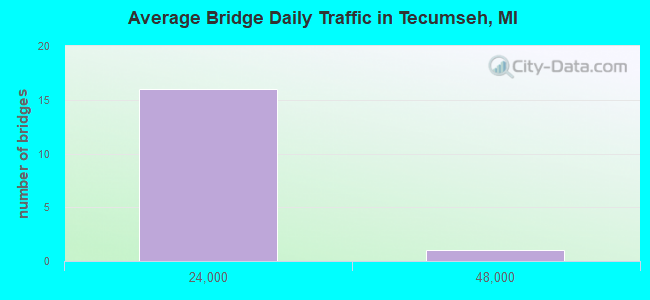
- 108,332Total average daily traffic
- 4,408Total average daily truck traffic
- 138,863Total future (year 2012) average daily traffic
- National Bridge Inventory (NBI) Registered Bridges for Tecumseh
- No street view available for this location
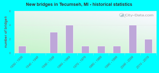
- New bridges - historical statistics
- 11930-1939
- 31950-1959
- 41960-1969
- 11970-1979
- 11980-1989
- 11990-1999
- 42000-2009
- 22010-2019
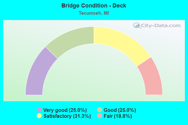
- Bridge Condition - Deck
- 25.0%Very good
- 25.0%Good
- 31.3%Satisfactory
- 18.8%Fair
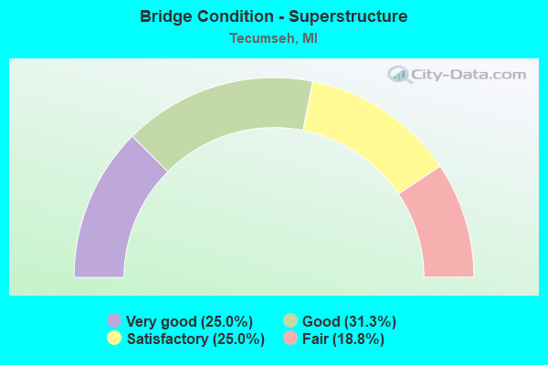
- Bridge Condition - Superstructure
- 25.0%Very good
- 31.3%Good
- 25.0%Satisfactory
- 18.8%Fair
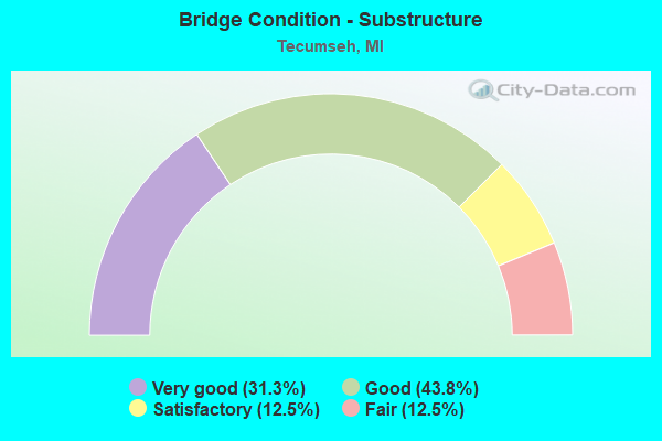
- Bridge Condition - Substructure
- 31.3%Very good
- 43.8%Good
- 12.5%Satisfactory
- 12.5%Fair
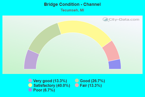
- Bridge Condition - Channel
- 13.3%Very good
- 26.7%Good
- 40.0%Satisfactory
- 13.3%Fair
- 6.7%Poor
Find on map >> Show street view
Structure Number: 3083, Location: 0.5 MI W OF ST LOUIS (Lat: 43.396383, Lng: -84.632183), Route carried "on" structure: US 127, Year Built: 1961, Status: Open, Structure Length: 4.63m (15.19ft), Average Daily Traffic: 8,293 (year 2007), Truck Traffic: 8%, Average Future Daily Traffic: 11,739 (year 2018), Design Load: HS 20, Features Intersected: PINE RIVER
Minimum Vertical Clearance: 30.48m (100.00ft), Kilometerpoint: 33.179, Lanes on structure: 2, Base Highway Network: Yes (Inventory Route: 49, Subroute: 2), Owner: State Highway Agency, Approaching Roadway Width: 17.7m (58.1ft), Skew: 12 degrees, Material/Design: Steel, Design/Construction: Stringer/Multi-beam, Number Of Spans In Main Unit: 3, Length of Maximum Span: 15.5m (50.9ft), Curb-To-Curb Width: 13.4m (44.0ft), Out-to-Out Width: 14.3m (46.9ft)
Condition: Deck: Fair, Superstructure: Satisfactory, Substructure: Good, Channel: Good, Operating Rating: 60.6 metric tons, Method Used To Determine Operating Rating: Load Factor (LF) rating reported by rating factor (RF) method using MS18 loading, Inventory Rating: 36.3 metric tons, Method Used To Determine Inventory Rating: Load Factor (LF) rating reported by rating factor (RF) method using MS18 loading, Structural Evaluation: Equal to present minimum criteria, Deck Geometry: Superior to present desirable criteria, Waterway Adequacy: Better than present minimum criteria, Approach Roadway Alignment: Better than present minimum criteria, Designated Inspection Frequency: Every 24 months, Underwater Inspection Frequency: Every 60 months, Other Special Inspection Frequency: Every 12 months, Inspection Date: June 2021, Underwater Inspection Date: September 2020, Other Special Inspection Date: June 2021, Deck Structure Type: Concrete Cast-file-Place, Wearing Surface/Protective System: Wearing Surface: Epoxy Overlay
Find on map >> Show street view
Structure Number: 3095, Location: 1.0 MI E OF ITHACA (Lat: 43.291647, Lng: -84.582336), Route carried "on" structure: US 127, Year Built: 1959, Status: Open, Structure Length: 4.08m (13.39ft), Average Daily Traffic: 8,987 (year 2007), Truck Traffic: 7%, Average Future Daily Traffic: 12,958 (year 2018), Design Load: HS 20, Features Intersected: US-127 BR
Minimum Vertical Clearance: 30.48m (100.00ft), Kilometerpoint: 19.862, Lanes on structure: 2, Lanes under structure: 4, Base Highway Network: Yes (Inventory Route: 49, Subroute: 2), Owner: State Highway Agency, Approaching Roadway Width: 17.6m (57.7ft), Skew: 10 degrees, Material/Design: Steel, Design/Construction: Stringer/Multi-beam, Number Of Spans In Main Unit: 3, Length of Maximum Span: 19.2m (63.0ft), Curb-To-Curb Width: 12.8m (42.0ft), Out-to-Out Width: 14.4m (47.2ft)
Condition: Deck: Fair, Superstructure: Fair, Substructure: Good, Operating Rating: 66.7 metric tons, Method Used To Determine Operating Rating: Load Factor (LF) rating reported by rating factor (RF) method using MS18 loading, Inventory Rating: 39.9 metric tons, Method Used To Determine Inventory Rating: Load Factor (LF) rating reported by rating factor (RF) method using MS18 loading, Structural Evaluation: Somewhat better than minimum adequacy, Deck Geometry: Equal to present desirable criteria, Underclear: Somewhat better than minimum adequacy, Approach Roadway Alignment: Equal to present desirable criteria, Designated Inspection Frequency: Every 24 months, Inspection Date: November 2020, Deck Structure Type: Concrete Cast-file-Place, Wearing Surface/Protective System: Wearing Surface: Latex Concrete
Find on map >> Show street view
Structure Number: 4559, Location: 2.3 MI N OF I-94 (Lat: 42.268589, Lng: -85.653564), Route carried "on" structure: Business Interstate 94, Year Built: 2015, Status: Open, Structure Length: 4.67m (15.32ft), Average Daily Traffic: 36,361 (year 2012), Truck Traffic: 2%, Average Future Daily Traffic: 40,578 (year 2032), Design Load: Greater than HL93, Features Intersected: US-131
Minimum Vertical Clearance: 30.48m (100.00ft), Kilometerpoint: 9.829, Lanes on structure: 6, Lanes under structure: 4, Base Highway Network: Yes (Inventory Route: 2, Subroute: 7), Owner: State Highway Agency, Approaching Roadway Width: 24.4m (80.1ft), Material/Design: Steel continuous, Design/Construction: Stringer/Multi-beam, Number Of Spans In Main Unit: 2, Length of Maximum Span: 22.7m (74.5ft), Curb or Sidewalk Widths: Left: 1.5m (4.9ft), Right: 4.3m (14.1ft), Curb-To-Curb Width: 37.1m (121.7ft), Out-to-Out Width: 44.3m (145.3ft)
Condition: Deck: Good, Superstructure: Good, Substructure: Very good, Operating Rating: 71.0 metric tons, Method Used To Determine Operating Rating: Load and Resistance Factor Rating (LRFR) rating reported by rating factor(RF) method using HL-93 loadings, Inventory Rating: 40.5 metric tons, Method Used To Determine Inventory Rating: Load and Resistance Factor Rating (LRFR) rating reported by rating factor(RF) method using HL-93 loadings, Structural Evaluation: Better than present minimum criteria, Deck Geometry: Superior to present desirable criteria, Underclear: Somewhat better than minimum adequacy, Approach Roadway Alignment: Better than present minimum criteria, Length Of Structure Improvement: 7.23m (23.72ft), Designated Inspection Frequency: Every 24 months, Inspection Date: September 2020, Bridge Improvement Cost: $483,000, Roadway Improvement Cost: $31,000, Total Project Cost: $363,000, Deck Structure Type: Concrete Cast-file-Place, Wearing Surface/Protective System: Wearing Surface: Monolithic Concrete, Deck Protection: Epoxy Coated Reinforcing
Find on map >> Show street view
Structure Number: 5533, Location: 4.0 MI NW OF TECUMSEH (Lat: 42.020694, Lng: -84.009619), Route carried "on" structure: State highway 52, Year Built: 1962, Status: Open, Structure Length: 1.70m (5.58ft), Average Daily Traffic: 4,256 (year 2007), Truck Traffic: 6%, Average Future Daily Traffic: 8,931 (year 2018), Design Load: HS 20, Features Intersected: EVANS CREEK
Minimum Vertical Clearance: 30.48m (100.00ft), Kilometerpoint: 14.916, Lanes on structure: 2, Base Highway Network: Yes (Inventory Route: 94, Subroute: 4), Owner: State Highway Agency, Approaching Roadway Width: 12.2m (40.0ft), Skew: 3 degrees, Material/Design: Steel, Design/Construction: Stringer/Multi-beam, Number Of Spans In Main Unit: 1, Length of Maximum Span: 17.0m (55.8ft), Curb or Sidewalk Widths: Left: 0.1m (0.3ft), Right: 0.1m (0.3ft), Curb-To-Curb Width: 13.0m (42.7ft), Out-to-Out Width: 13.7m (44.9ft)
Condition: Deck: Satisfactory, Superstructure: Good, Substructure: Good, Channel: Fair, Operating Rating: 64.5 metric tons, Method Used To Determine Operating Rating: Load Factor (LF) rating reported by rating factor (RF) method using MS18 loading, Inventory Rating: 38.6 metric tons, Method Used To Determine Inventory Rating: Load Factor (LF) rating reported by rating factor (RF) method using MS18 loading, Structural Evaluation: Better than present minimum criteria, Deck Geometry: Equal to present minimum criteria, Waterway Adequacy: Equal to present desirable criteria, Approach Roadway Alignment: Equal to present desirable criteria, Designated Inspection Frequency: Every 24 months, Inspection Date: July 2020, Deck Structure Type: Concrete Cast-file-Place, Wearing Surface/Protective System: Wearing Surface: Latex Concrete, Deck Protection: Epoxy Coated Reinforcing
Find on map >> Show street view
Structure Number: 5534, Location: 1.0 MI W OF M-52 (Lat: 42.011789, Lng: -84.023414), Route carried "on" structure: State highway 50, Year Built: 1997, Status: Open, Structure Length: 0.78m (2.56ft), Average Daily Traffic: 7,076 (year 2007), Truck Traffic: 7%, Average Future Daily Traffic: 9,272 (year 2018), Design Load: HS 25 or greater, Features Intersected: WILSON CREEK
Minimum Vertical Clearance: 30.48m (100.00ft), Kilometerpoint: 19.746, Lanes on structure: 2, Base Highway Network: Yes (Inventory Route: 94, Subroute: 5), Owner: State Highway Agency, Approaching Roadway Width: 13.1m (43.0ft), Material/Design: Concrete, Design/Construction: Culvert, Number Of Spans In Main Unit: 1, Length of Maximum Span: 7.8m (25.6ft), Out-to-Out Width: 18.3m (60.0ft)
Condition: Channel: Fair, Culverts: Good, Operating Rating: 58.6 metric tons, Method Used To Determine Operating Rating: Load Factor (LF) rating reported by rating factor (RF) method using MS18 loading, Inventory Rating: 36.3 metric tons, Method Used To Determine Inventory Rating: Load Factor (LF) rating reported by rating factor (RF) method using MS18 loading, Structural Evaluation: Better than present minimum criteria, Waterway Adequacy: Equal to present desirable criteria, Approach Roadway Alignment: Equal to present desirable criteria, Designated Inspection Frequency: Every 24 months, Inspection Date: July 2020, Wearing Surface/Protective System: Wearing Surface: Bituminous
Find on map >> Show street view
Structure Number: 5539, Location: 0.8 MI W OF RIDGEWAY (Lat: 41.995806, Lng: -83.876922), Route carried "on" structure: State highway 50, Year Built: 2000, Status: Open, Structure Length: 1.30m (4.27ft), Average Daily Traffic: 10,637 (year 2007), Truck Traffic: 7%, Average Future Daily Traffic: 12,233 (year 2027), Design Load: HS 25 or greater, Features Intersected: S BR MACON CREEK
Minimum Vertical Clearance: 30.48m (100.00ft), Kilometerpoint: 32.101, Lanes on structure: 2, Base Highway Network: Yes (Inventory Route: 94, Subroute: 5), Owner: State Highway Agency, Approaching Roadway Width: 13.1m (43.0ft), Material/Design: Prestressed concrete, Design/Construction: Box Beam or Girders - Multiple, Number Of Spans In Main Unit: 1, Length of Maximum Span: 11.8m (38.7ft), Curb-To-Curb Width: 13.4m (44.0ft), Out-to-Out Width: 14.3m (46.9ft)
Condition: Deck: Satisfactory, Superstructure: Good, Substructure: Good, Channel: Satisfactory, Operating Rating: 78.4 metric tons, Method Used To Determine Operating Rating: Load Factor (LF), Inventory Rating: 48.2 metric tons, Method Used To Determine Inventory Rating: Load Factor (LF), Structural Evaluation: Better than present minimum criteria, Deck Geometry: Equal to present minimum criteria, Waterway Adequacy: Equal to present minimum criteria, Approach Roadway Alignment: Equal to present desirable criteria, Designated Inspection Frequency: Every 24 months, Inspection Date: September 2020, Deck Structure Type: Concrete Cast-file-Place, Wearing Surface/Protective System: Wearing Surface: Monolithic Concrete, Deck Protection: Epoxy Coated Reinforcing
Find on map >> Show street view
Structure Number: 5575, Location: 0.3 MI E OF RAISIN CENTER (Lat: 41.949186, Lng: -83.941492), Route carried "on" structure: County highway , Year Built: 1960, Status: Open, Structure Length: 3.84m (12.60ft), Average Daily Traffic: 3,190 (year 2011), Truck Traffic: 10%, Average Future Daily Traffic: 4,000 (year 2031), Design Load: H 20, Features Intersected: N BRANCH RIVER RAISIN, Facility Carried by Structure: SUTTON RD
Minimum Vertical Clearance: 30.48m (100.00ft), Kilometerpoint: 5.232, Lanes on structure: 2, Owner: County Highway Agency, Approaching Roadway Width: 10.1m (33.1ft), Skew: 2 degrees, Material/Design: Prestressed concrete, Design/Construction: Box Beam or Girders - Multiple, Number Of Spans In Main Unit: 3, Length of Maximum Span: 12.8m (42.0ft), Curb or Sidewalk Widths: Left: 0.5m (1.6ft), Right: 0.5m (1.6ft), Curb-To-Curb Width: 7.9m (25.9ft), Out-to-Out Width: 9.3m (30.5ft)
Condition: Deck: Satisfactory, Superstructure: Satisfactory, Substructure: Fair, Channel: Satisfactory, Operating Rating: 62.2 metric tons, Method Used To Determine Operating Rating: Load Factor (LF), Inventory Rating: 37.3 metric tons, Method Used To Determine Inventory Rating: Load Factor (LF), Structural Evaluation: Somewhat better than minimum adequacy, Deck Geometry: High priority of corrective action, Waterway Adequacy: Equal to present desirable criteria, Approach Roadway Alignment: Better than present minimum criteria, Designated Inspection Frequency: Every 24 months, Inspection Date: March 2022, Deck Structure Type: Concrete Precast Panels, Wearing Surface/Protective System: Wearing Surface: Bituminous
Find on map >> Show street view
Structure Number: 5646, Location: 0.5 MI N OF M-50 (Lat: 42.015867, Lng: -84.015361), Route carried "on" structure: County highway , Year Built: 2003, Status: Open, Structure Length: 1.95m (6.40ft), Average Daily Traffic: 144 (year 2011), Truck Traffic: 1%, Average Future Daily Traffic: 200 (year 2031), Design Load: HS 25 or greater, Features Intersected: EVANS CREEK, Facility Carried by Structure: BRAMBLE HWY
Minimum Vertical Clearance: 30.48m (100.00ft), Kilometerpoint: 1.757, Lanes on structure: 2, Owner: County Highway Agency, Approaching Roadway Width: 10.4m (34.1ft), Skew: 2 degrees, Material/Design: Prestressed concrete, Design/Construction: Box Beam or Girders - Multiple, Number Of Spans In Main Unit: 1, Length of Maximum Span: 18.3m (60.0ft), Curb-To-Curb Width: 8.8m (28.9ft), Out-to-Out Width: 9.5m (31.2ft)
Condition: Deck: Very good, Superstructure: Very good, Substructure: Very good, Channel: Good, Operating Rating: 70.8 metric tons, Method Used To Determine Operating Rating: Load Factor (LF), Inventory Rating: 42.5 metric tons, Method Used To Determine Inventory Rating: Load Factor (LF), Structural Evaluation: Equal to present desirable criteria, Deck Geometry: Equal to present minimum criteria, Waterway Adequacy: Superior to present desirable criteria, Approach Roadway Alignment: Superior to present desirable criteria, Designated Inspection Frequency: Every 24 months, Inspection Date: January 2021, Deck Structure Type: Concrete Cast-file-Place, Wearing Surface/Protective System: Wearing Surface: Monolithic Concrete, Deck Protection: Epoxy Coated Reinforcing
Find on map >> Show street view
Structure Number: 5685, Location: 0.4 MI SOUTH OF SUTTON RD (Lat: 41.942983, Lng: -83.945039), Route carried "on" structure: County highway , Year Built: 1981, Status: Posted for load, Structure Length: 3.96m (12.99ft), Average Daily Traffic: 1,103 (year 2011), Truck Traffic: 1%, Average Future Daily Traffic: 1,700 (year 2031), Design Load: HS 20, Features Intersected: RIVER RAISIN, Facility Carried by Structure: RAISIN CENTER HWY
Minimum Vertical Clearance: 30.48m (100.00ft), Kilometerpoint: 6.681, Lanes on structure: 2, Owner: County Highway Agency, Approaching Roadway Width: 10.1m (33.1ft), Material/Design: Wood or Timber, Design/Construction: Slab, Number Of Spans In Main Unit: 5, Length of Maximum Span: 7.9m (25.9ft), Curb-To-Curb Width: 8.5m (27.9ft), Out-to-Out Width: 9.1m (29.9ft)
Condition: Deck: Fair, Superstructure: Fair, Substructure: Good, Channel: Satisfactory, Operating Rating: 39.2 metric tons, Method Used To Determine Operating Rating: Allowable Stress (AS) rating reported by rating factor (RF) method using MS18 loading, Inventory Rating: 26.2 metric tons, Method Used To Determine Inventory Rating: Allowable Stress (AS) rating reported by rating factor (RF) method using MS18 loading, Structural Evaluation: Somewhat better than minimum adequacy, Deck Geometry: Somewhat better than minimum adequacy, Waterway Adequacy: Equal to present minimum criteria, Approach Roadway Alignment: Superior to present desirable criteria, Bridge Posting: Required (Relationship of Operating Rating to Maximum Legal Load: 10.0 - 19.9% below), Designated Inspection Frequency: Every 12 months, Inspection Date: April 2021, Deck Structure Type: Wood or Timber, Wearing Surface/Protective System: Wearing Surface: Bituminous, Deck Protection: Other
Find on map >> Show street view
Structure Number: 5713, Location: 0.3 MI SOUTH OF MUNGER RD (Lat: 42.021361, Lng: -84.005758), Route carried "on" structure: County highway , Year Built: 2004, Status: Open, Structure Length: 2.07m (6.79ft), Average Daily Traffic: 385 (year 2011), Truck Traffic: 1%, Average Future Daily Traffic: 800 (year 2031), Design Load: HS 25 or greater, Features Intersected: EVANS CREEK, Facility Carried by Structure: N ADRIAN HWY
Minimum Vertical Clearance: 30.48m (100.00ft), Kilometerpoint: 0.921, Lanes on structure: 2, Owner: County Highway Agency, Approaching Roadway Width: 9.8m (32.2ft), Material/Design: Prestressed concrete, Design/Construction: Box Beam or Girders - Multiple, Number Of Spans In Main Unit: 1, Length of Maximum Span: 19.5m (64.0ft), Curb-To-Curb Width: 8.8m (28.9ft), Out-to-Out Width: 9.5m (31.2ft)
Condition: Deck: Very good, Superstructure: Very good, Substructure: Very good, Channel: Very good, Operating Rating: 79.4 metric tons, Method Used To Determine Operating Rating: Load Factor (LF), Inventory Rating: 47.6 metric tons, Method Used To Determine Inventory Rating: Load Factor (LF), Structural Evaluation: Equal to present desirable criteria, Deck Geometry: Equal to present minimum criteria, Waterway Adequacy: Equal to present minimum criteria, Approach Roadway Alignment: Equal to present minimum criteria, Designated Inspection Frequency: Every 24 months, Inspection Date: July 2021, Deck Structure Type: Concrete Cast-file-Place, Wearing Surface/Protective System: Wearing Surface: Monolithic Concrete, Deck Protection: Epoxy Coated Reinforcing
Find on map >> Show street view
Structure Number: 5725, Location: 1000FT W ROGER HWY (Lat: 41.992236, Lng: -83.930311), Route carried "on" structure: City street 4668, Year Built: 1979, Status: Open, Structure Length: 4.57m (14.99ft), Average Daily Traffic: 3,660 (year 2003), Truck Traffic: 7%, Average Future Daily Traffic: 3,900 (year 2012), Design Load: HS 20+Mod, Features Intersected: RAISIN RIVER, Facility Carried by Structure: E RUSSELL ROAD
Minimum Vertical Clearance: 30.48m (100.00ft), Kilometerpoint: 6.162, Lanes on structure: 2, Owner: City or Municipal Highway Agency, Approaching Roadway Width: 9.1m (29.9ft), Skew: 2 degrees, Material/Design: Prestressed concrete, Design/Construction: Box Beam or Girders - Multiple, Number Of Spans In Main Unit: 3, Length of Maximum Span: 15.2m (49.9ft), Curb-To-Curb Width: 10.1m (33.1ft), Out-to-Out Width: 11.1m (36.4ft)
Condition: Deck: Satisfactory, Superstructure: Fair, Substructure: Good, Channel: Satisfactory, Operating Rating: 60.3 metric tons, Method Used To Determine Operating Rating: Load Factor (LF) rating reported by rating factor (RF) method using MS18 loading, Inventory Rating: 33.0 metric tons, Method Used To Determine Inventory Rating: Load Factor (LF) rating reported by rating factor (RF) method using MS18 loading, Structural Evaluation: Somewhat better than minimum adequacy, Deck Geometry: Meets minimum limits, Waterway Adequacy: Superior to present desirable criteria, Approach Roadway Alignment: Equal to present desirable criteria, Designated Inspection Frequency: Every 24 months, Inspection Date: September 2021, Wearing Surface/Protective System: Wearing Surface: Bituminous
Find on map >> Show street view
Structure Number: 5726, Location: 539FT NORTH OF JAMES ST (Lat: 42.010725, Lng: -83.940414), Route carried "on" structure: City street , Year Built: 1961, Status: Open, Structure Length: 2.28m (7.48ft), Average Daily Traffic: 4,035 (year 2005), Average Future Daily Traffic: 4,640 (year 2025), Design Load: HS 20+Mod, Features Intersected: EVANS CREEK, Facility Carried by Structure: N MAUMEE STREET
Minimum Vertical Clearance: 30.48m (100.00ft), Kilometerpoint: 2.036, Lanes on structure: 2, Owner: City or Municipal Highway Agency, Approaching Roadway Width: 12.5m (41.0ft), Material/Design: Prestressed concrete, Design/Construction: Box Beam or Girders - Multiple, Number Of Spans In Main Unit: 2, Length of Maximum Span: 11.5m (37.7ft), Curb or Sidewalk Widths: Left: 1.5m (4.9ft), Right: 0.4m (1.3ft), Curb-To-Curb Width: 7.9m (25.9ft), Out-to-Out Width: 10.4m (34.1ft)
Condition: Deck: Good, Superstructure: Good, Substructure: Fair, Channel: Poor, Operating Rating: 77.1 metric tons, Method Used To Determine Operating Rating: Load and Resistance Factor Rating (LRFR) rating reported by rating factor(RF) method using HL-93 loadings, Inventory Rating: 56.4 metric tons, Method Used To Determine Inventory Rating: Load and Resistance Factor Rating (LRFR) rating reported by rating factor(RF) method using HL-93 loadings, Structural Evaluation: Somewhat better than minimum adequacy, Deck Geometry: High priority of corrective action, Waterway Adequacy: Superior to present desirable criteria, Approach Roadway Alignment: Meets minimum limits, Designated Inspection Frequency: Every 24 months, Inspection Date: September 2021, Wearing Surface/Protective System: Wearing Surface: Bituminous
Find on map >> Show street view
Structure Number: 5727, Location: 1OOFT N OF N OTTAWA ST (Lat: 42.008675, Lng: -83.944392), Route carried "on" structure: City street 2044, Year Built: 1953, Status: Open, Structure Length: 3.41m (11.19ft), Average Daily Traffic: 5,644 (year 1997), Truck Traffic: 5%, Average Future Daily Traffic: 10,700 (year 2012), Design Load: HS 20+Mod, Features Intersected: EVANS CREEK, Facility Carried by Structure: N EVANS ST
Minimum Vertical Clearance: 30.48m (100.00ft), Kilometerpoint: 6.743, Lanes on structure: 2, Owner: City or Municipal Highway Agency, Approaching Roadway Width: 11.6m (38.1ft), Skew: 1 degrees, Material/Design: Steel, Design/Construction: Stringer/Multi-beam, Number Of Spans In Main Unit: 3, Length of Maximum Span: 13.1m (43.0ft), Curb or Sidewalk Widths: Left: 1.5m (4.9ft), Right: 1.5m (4.9ft), Curb-To-Curb Width: 11.6m (38.1ft), Out-to-Out Width: 15.4m (50.5ft)
Condition: Deck: Satisfactory, Superstructure: Satisfactory, Substructure: Satisfactory, Channel: Good, Operating Rating: 97.2 metric tons, Method Used To Determine Operating Rating: Load Factor (LF) rating reported by rating factor (RF) method using MS18 loading, Inventory Rating: 58.3 metric tons, Method Used To Determine Inventory Rating: Load Factor (LF) rating reported by rating factor (RF) method using MS18 loading, Structural Evaluation: Equal to present minimum criteria, Deck Geometry: Somewhat better than minimum adequacy, Waterway Adequacy: Equal to present desirable criteria, Approach Roadway Alignment: Equal to present desirable criteria, Designated Inspection Frequency: Every 24 months, Inspection Date: September 2021, Deck Structure Type: Concrete Cast-file-Place, Wearing Surface/Protective System: Wearing Surface: Bituminous
Find on map >> Show street view
Structure Number: 5728, Location: 300FT N OF BROWN ST (Lat: 42.014258, Lng: -83.941503), Route carried "on" structure: City street 2044, Year Built: 1958, Status: Open, Structure Length: 8.23m (27.00ft), Average Daily Traffic: 9,505 (year 2002), Average Future Daily Traffic: 10,931 (year 2022), Design Load: HS 20+Mod, Features Intersected: RAISIN RIVER, Facility Carried by Structure: N EVANS ST
Minimum Vertical Clearance: 30.48m (100.00ft), Kilometerpoint: 7.411, Lanes on structure: 2, Owner: City or Municipal Highway Agency, Approaching Roadway Width: 11.6m (38.1ft), Material/Design: Steel, Design/Construction: Stringer/Multi-beam, Number Of Spans In Main Unit: 4, Length of Maximum Span: 25.9m (85.0ft), Curb or Sidewalk Widths: Left: 1.2m (3.9ft), Right: 1.2m (3.9ft), Curb-To-Curb Width: 7.9m (25.9ft), Out-to-Out Width: 11.1m (36.4ft)
Condition: Deck: Good, Superstructure: Satisfactory, Substructure: Good, Channel: Good, Operating Rating: 77.8 metric tons, Method Used To Determine Operating Rating: Load Factor (LF) rating reported by rating factor (RF) method using MS18 loading, Inventory Rating: 46.7 metric tons, Method Used To Determine Inventory Rating: Load Factor (LF) rating reported by rating factor (RF) method using MS18 loading, Structural Evaluation: Equal to present minimum criteria, Deck Geometry: High priority of corrective action, Waterway Adequacy: Equal to present minimum criteria, Approach Roadway Alignment: Equal to present minimum criteria, Designated Inspection Frequency: Every 24 months, Inspection Date: September 2021, Deck Structure Type: Concrete Cast-file-Place, Wearing Surface/Protective System: Wearing Surface: Monolithic Concrete, Deck Protection: Other
Find on map >> Show street view
Structure Number: 5729, Location: 283FT N OF CHIPPEWA ST (Lat: 42.010439, Lng: -83.950283), Route carried "on" structure: City street , Year Built: 1934, Year Reconstructed: 1975, Status: Open, Structure Length: 1.15m (3.77ft), Average Daily Traffic: 2,657 (year 2007), Average Future Daily Traffic: 3,056 (year 2027), Design Load: HS 20, Features Intersected: EVANS CREEK, Facility Carried by Structure: N UNION STREET
Minimum Vertical Clearance: 30.48m (100.00ft), Kilometerpoint: 2.078, Lanes on structure: 2, Owner: City or Municipal Highway Agency, Approaching Roadway Width: 10.7m (35.1ft), Skew: 3 degrees, Material/Design: Prestressed concrete, Design/Construction: Box Beam or Girders - Multiple, Number Of Spans In Main Unit: 1, Length of Maximum Span: 10.3m (33.8ft), Curb or Sidewalk Widths: Left: 1.5m (4.9ft), Right: 0.9m (3.0ft), Curb-To-Curb Width: 10.7m (35.1ft), Out-to-Out Width: 13.6m (44.6ft)
Condition: Deck: Good, Superstructure: Good, Substructure: Satisfactory, Channel: Satisfactory, Operating Rating: 97.2 metric tons, Method Used To Determine Operating Rating: Load Factor (LF) rating reported by rating factor (RF) method using MS18 loading, Inventory Rating: 63.5 metric tons, Method Used To Determine Inventory Rating: Load Factor (LF) rating reported by rating factor (RF) method using MS18 loading, Structural Evaluation: Equal to present minimum criteria, Deck Geometry: Somewhat better than minimum adequacy, Waterway Adequacy: Equal to present desirable criteria, Approach Roadway Alignment: Superior to present desirable criteria, Designated Inspection Frequency: Every 24 months, Inspection Date: September 2021, Wearing Surface/Protective System: Wearing Surface: Bituminous
Find on map >> Show street view
Structure Number: 13115, Location: 0.5 MI S OF MUNGER RD (Lat: 42.019158, Lng: -83.984981), Route carried "on" structure: County highway , Year Built: 2000, Status: Open, Structure Length: 0.73m (2.40ft), Average Daily Traffic: 2,379 (year 2011), Truck Traffic: 1%, Average Future Daily Traffic: 3,200 (year 2031), Design Load: HS 20, Features Intersected: EVANS CREEK, Facility Carried by Structure: MATTHEWS HWY
Minimum Vertical Clearance: 30.48m (100.00ft), Kilometerpoint: 1.366, Lanes on structure: 2, Owner: County Highway Agency, Approaching Roadway Width: 8.5m (27.9ft), Material/Design: Wood or Timber, Design/Construction: Slab, Number Of Spans In Main Unit: 1, Length of Maximum Span: 6.7m (22.0ft), Curb-To-Curb Width: 9.1m (29.9ft), Out-to-Out Width: 9.6m (31.5ft)
Condition: Deck: Very good, Superstructure: Very good, Substructure: Very good, Channel: Satisfactory, Operating Rating: 46.6 metric tons, Method Used To Determine Operating Rating: Allowable Stress (AS), Inventory Rating: 32.7 metric tons, Method Used To Determine Inventory Rating: Allowable Stress (AS), Structural Evaluation: Equal to present desirable criteria, Deck Geometry: Meets minimum limits, Waterway Adequacy: Equal to present minimum criteria, Approach Roadway Alignment: Equal to present minimum criteria, Designated Inspection Frequency: Every 24 months, Inspection Date: Febuary 2022, Deck Structure Type: Wood or Timber, Wearing Surface/Protective System: Wearing Surface: Wood or Timber
Find on map >> Show street view
Structure Number: 13831, Location: 0.9 MI N OF LINDY RD (Lat: 44.533236, Lng: -85.878347), Route carried "on" structure: County highway , Year Built: 2014, Status: Open, Structure Length: 0.67m (2.20ft), Average Daily Traffic: 20 (year 2014), Average Future Daily Traffic: 25 (year 2034), Design Load: HL 93, Features Intersected: LITTLE BETSIE RIVER, Facility Carried by Structure: NESSEN ROAD
Minimum Vertical Clearance: 30.48m (100.00ft), Kilometerpoint: 3.265, Lanes on structure: 2, Owner: County Highway Agency, Approaching Roadway Width: 4.3m (14.1ft), Material/Design: Wood or Timber, Design/Construction: Slab, Number Of Spans In Main Unit: 1, Length of Maximum Span: 6.1m (20.0ft), Curb-To-Curb Width: 4.3m (14.1ft), Out-to-Out Width: 4.7m (15.4ft)
Condition: Deck: Very good, Superstructure: Very good, Substructure: Very good, Channel: Very good, Operating Rating: 48.6 metric tons, Method Used To Determine Operating Rating: Load and Resistance Factor Rating (LRFR) rating reported by rating factor(RF) method using HL-93 loadings, Inventory Rating: 37.6 metric tons, Method Used To Determine Inventory Rating: Load and Resistance Factor Rating (LRFR) rating reported by rating factor(RF) method using HL-93 loadings, Structural Evaluation: Equal to present desirable criteria, Deck Geometry: High priority of replacement, Waterway Adequacy: Equal to present desirable criteria, Approach Roadway Alignment: Equal to present minimum criteria, Designated Inspection Frequency: Every 24 months, Inspection Date: August 2020, Deck Structure Type: Wood or Timber, Wearing Surface/Protective System: Wearing Surface: Bituminous, Deck Protection: Other