Bridge Statistics for Theodore, Alabama (AL)
Condition, Traffic, Stress, Structural Evaluation, Project Costs
- National Bridge Inventory (NBI) Statistics
- 30Number of bridges
- 262ft / 80.1mTotal length
- $37,449,000Total costs
- 272,886Total average daily traffic
- 33,840Total average daily truck traffic
- National Bridge Inventory (NBI) Registered Bridges for Theodore
- No street view available for this location
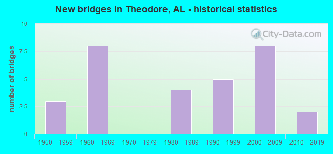
- New bridges - historical statistics
- 31950-1959
- 81960-1969
- 41980-1989
- 51990-1999
- 82000-2009
- 22010-2019
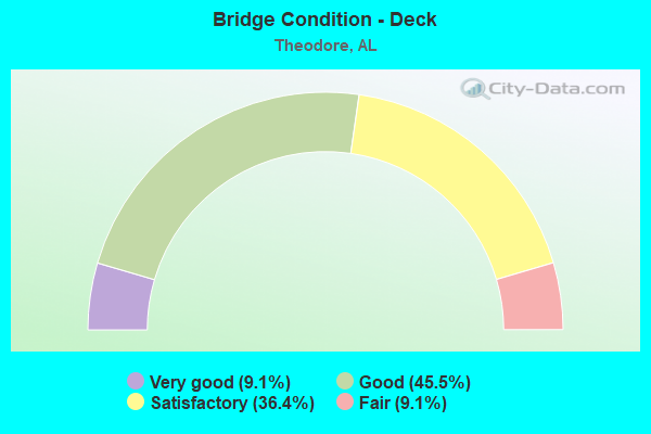
- Bridge Condition - Deck
- 9.1%Very good
- 45.5%Good
- 36.4%Satisfactory
- 9.1%Fair
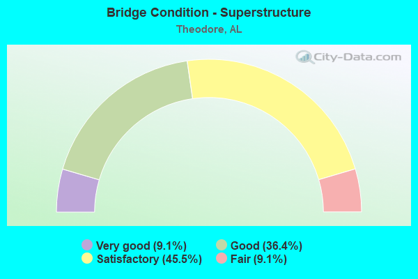
- Bridge Condition - Superstructure
- 9.1%Very good
- 36.4%Good
- 45.5%Satisfactory
- 9.1%Fair
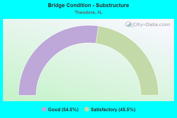
- Bridge Condition - Substructure
- 54.5%Good
- 45.5%Satisfactory
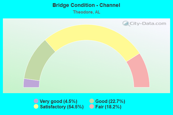
- Bridge Condition - Channel
- 4.5%Very good
- 22.7%Good
- 54.5%Satisfactory
- 18.2%Fair
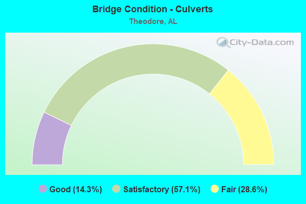
- Bridge Condition - Culverts
- 14.3%Good
- 57.1%Satisfactory
- 28.6%Fair
Find on map >> Show street view
Structure Number: 3609, Location: 0.9 MI S US 90 (Lat: 30.535503, Lng: -88.170625), Route carried "on" structure: County highway , Year Built: 1992, Status: Open, Structure Length: 1.04m (3.41ft), Average Daily Traffic: 10,367 (year 2020), Truck Traffic: 7%, Average Future Daily Traffic: 15,405 (year 2040), Design Load: HS 20, Features Intersected: MUDDY CREEK, Facility Carried by Structure: BELLINGRATH RD
Minimum Vertical Clearance: 30+ m (98+ ft), Kilometerpoint: 0.900, Lanes on structure: 2, Owner: County Highway Agency, Approaching Roadway Width: 7.3m (24.0ft), Material/Design: Concrete, Design/Construction: Channel Beam, Number Of Spans In Main Unit: 1, Length of Maximum Span: 10.4m (34.1ft), Curb-To-Curb Width: 10.5m (34.4ft), Out-to-Out Width: 10.5m (34.4ft)
Condition: Deck: Satisfactory, Superstructure: Satisfactory, Substructure: Good, Channel: Satisfactory, Operating Rating: 74.4 metric tons, Method Used To Determine Operating Rating: Load Factor (LF), Inventory Rating: 44.5 metric tons, Method Used To Determine Inventory Rating: Load Factor (LF), Structural Evaluation: Equal to present minimum criteria, Deck Geometry: Meets minimum limits, Waterway Adequacy: Better than present minimum criteria, Approach Roadway Alignment: Better than present minimum criteria, Length Of Structure Improvement: 1.71m (5.61ft), Designated Inspection Frequency: Every 24 months, Inspection Date: May 2020, Bridge Improvement Cost: $398,000, Roadway Improvement Cost: $40,000, Total Project Cost: $438,000 ( Estimate for 2022), Deck Structure Type: Concrete Precast Panels
Find on map >> Show street view
Structure Number: 4316, Location: 1.4 MI W I-10 (Lat: 30.559600, Lng: -88.172725), Route carried "on" structure: US 90, Year Built: 1952, Status: Open, Structure Length: 1.58m (5.18ft), Average Daily Traffic: 21,268 (year 2019), Truck Traffic: 6%, Average Future Daily Traffic: 31,902 (year 2039), Design Load: H 15, Features Intersected: RABBIT CREEK
Minimum Vertical Clearance: 30+ m (98+ ft), Kilometerpoint: 25.476, Lanes on structure: 4, Owner: State Highway Agency, Approaching Roadway Width: 17.6m (57.7ft), Skew: 20 degrees, Material/Design: Concrete, Design/Construction: Culvert, Number Of Spans In Main Unit: 5, Length of Maximum Span: 3.0m (9.8ft)
Condition: Channel: Satisfactory, Culverts: Fair, Operating Rating: 38.0 metric tons, Method Used To Determine Operating Rating: Load Factor (LF), Inventory Rating: 22.8 metric tons, Method Used To Determine Inventory Rating: Load Factor (LF), Structural Evaluation: Somewhat better than minimum adequacy, Waterway Adequacy: Equal to present minimum criteria, Approach Roadway Alignment: Equal to present desirable criteria, Length Of Structure Improvement: 2.27m (7.45ft), Designated Inspection Frequency: Every 24 months, Inspection Date: July 2020, Bridge Improvement Cost: $1,350,000, Roadway Improvement Cost: $135,000, Total Project Cost: $1,485,000 ( Estimate for 2022)
Find on map >> Show street view
Structure Number: 7291, Location: 0.7 MI W CO RD 19 (Lat: 30.494394, Lng: -88.244633), Route carried "on" structure: County highway , Year Built: 1961, Status: Open, Structure Length: 0.76m (2.49ft), Average Daily Traffic: 2,474 (year 2020), Truck Traffic: 2%, Average Future Daily Traffic: 3,676 (year 2040), Design Load: H 20, Features Intersected: HAMMAR CREEK, Facility Carried by Structure: HALF-MILE ROAD
Minimum Vertical Clearance: 30+ m (98+ ft), Kilometerpoint: 0.010, Lanes on structure: 2, Owner: County Highway Agency, Approaching Roadway Width: 7.3m (24.0ft), Skew: 3 degrees, Material/Design: Concrete continuous, Design/Construction: Culvert, Number Of Spans In Main Unit: 2, Length of Maximum Span: 3.8m (12.5ft)
Condition: Channel: Fair, Culverts: Satisfactory, Operating Rating: 41.4 metric tons, Method Used To Determine Operating Rating: Load Factor (LF), Inventory Rating: 24.9 metric tons, Method Used To Determine Inventory Rating: Load Factor (LF), Structural Evaluation: Equal to present minimum criteria, Waterway Adequacy: Better than present minimum criteria, Approach Roadway Alignment: Better than present minimum criteria, Length Of Structure Improvement: 1.41m (4.63ft), Designated Inspection Frequency: Every 24 months, Inspection Date: May 2020, Bridge Improvement Cost: $358,000, Roadway Improvement Cost: $36,000, Total Project Cost: $394,000 ( Estimate for 2022)
Find on map >> Show street view
Structure Number: 7893, Location: 0.8 MI N US 90 (Lat: 30.558625, Lng: -88.180994), Route carried "on" structure: County highway , Year Built: 1963, Status: Posted for load, Structure Length: 2.74m (8.99ft), Average Daily Traffic: 6,781 (year 2021), Truck Traffic: 2%, Average Future Daily Traffic: 10,076 (year 2041), Design Load: H 15, Features Intersected: RABBIT CREEK, Facility Carried by Structure: CAROL PLANTATION R
Minimum Vertical Clearance: 30+ m (98+ ft), Kilometerpoint: 0.800, Lanes on structure: 2, Owner: County Highway Agency, Approaching Roadway Width: 7.3m (24.0ft), Material/Design: Concrete, Design/Construction: Tee Beam, Number Of Spans In Main Unit: 3, Length of Maximum Span: 9.1m (29.9ft), Curb or Sidewalk Widths: Left: 0.5m (1.6ft), Right: 0.5m (1.6ft), Curb-To-Curb Width: 7.2m (23.6ft), Out-to-Out Width: 8.4m (27.6ft)
Condition: Deck: Fair, Superstructure: Fair, Substructure: Satisfactory, Channel: Satisfactory, Operating Rating: 31.4 metric tons, Method Used To Determine Operating Rating: Load Factor (LF), Inventory Rating: 18.9 metric tons, Method Used To Determine Inventory Rating: Load Factor (LF), Structural Evaluation: Meets minimum limits, Deck Geometry: High priority of replacement, Waterway Adequacy: Equal to present minimum criteria, Approach Roadway Alignment: Better than present minimum criteria, Bridge Posting: Required (Relationship of Operating Rating to Maximum Legal Load: 20.0 - 29.9% below), Length Of Structure Improvement: 3.66m (12.01ft), Designated Inspection Frequency: Every 24 months, Underwater Inspection Frequency: Every 24 months, Other Special Inspection Frequency: Every 12 months, Inspection Date: May 2020, Underwater Inspection Date: May 2020, Other Special Inspection Date: May 2021, Bridge Improvement Cost: $678,000, Roadway Improvement Cost: $68,000, Total Project Cost: $746,000 ( Estimate for 2022)
Find on map >> Show street view
Structure Number: 8127, Location: 4.2 MI W US 90 (Lat: 30.543939, Lng: -88.226067), Route carried "on" structure: Interstate 10, Year Built: 1964, Status: Open, Structure Length: 1.91m (6.27ft), Average Daily Traffic: 54,543 (year 2020), Truck Traffic: 24%, Average Future Daily Traffic: 81,815 (year 2040), Design Load: HS 20, Features Intersected: FOWL RIVER
Minimum Vertical Clearance: 30+ m (98+ ft), Kilometerpoint: 18.503, Lanes on structure: 4, Base Highway Network: Yes, Owner: State Highway Agency, Approaching Roadway Width: 21.9m (71.9ft), Skew: 10 degrees, Material/Design: Concrete, Design/Construction: Culvert, Number Of Spans In Main Unit: 5, Length of Maximum Span: 3.7m (12.1ft)
Condition: Channel: Fair, Culverts: Fair, Operating Rating: 69.8 metric tons, Method Used To Determine Operating Rating: Load Factor (LF), Inventory Rating: 41.7 metric tons, Method Used To Determine Inventory Rating: Load Factor (LF), Structural Evaluation: Somewhat better than minimum adequacy, Waterway Adequacy: Superior to present desirable criteria, Approach Roadway Alignment: Equal to present desirable criteria, Length Of Structure Improvement: 2.65m (8.69ft), Designated Inspection Frequency: Every 24 months, Inspection Date: December 2021, Bridge Improvement Cost: $2,888,000, Roadway Improvement Cost: $289,000, Total Project Cost: $3,177,000 ( Estimate for 2022)
Find on map >> Show street view
Structure Number: 8132, Location: 0.9 MI W JCT US 90 (Lat: 30.574686, Lng: -88.182419), Route carried "on" structure: County highway , Year Built: 1964, Status: Open, Structure Length: 10.67m (35.01ft), Average Daily Traffic: 6,305 (year 2020), Truck Traffic: 2%, Average Future Daily Traffic: 9,458 (year 2040), Design Load: H 20, Features Intersected: I-10, Facility Carried by Structure: CAROL PLANTATION
Minimum Vertical Clearance: 30+ m (98+ ft), Kilometerpoint: 0.000, Lanes on structure: 2, Lanes under structure: 4, Owner: State Highway Agency, Approaching Roadway Width: 7.3m (24.0ft), Skew: 4 degrees, Material/Design: Concrete continuous, Design/Construction: Tee Beam, Number Of Spans In Main Unit: 4, Length of Maximum Span: 29.3m (96.1ft), Curb-To-Curb Width: 7.3m (24.0ft), Out-to-Out Width: 8.8m (28.9ft)
Condition: Deck: Satisfactory, Superstructure: Satisfactory, Substructure: Satisfactory, Operating Rating: 62.5 metric tons, Method Used To Determine Operating Rating: Load Factor (LF), Inventory Rating: 37.1 metric tons, Method Used To Determine Inventory Rating: Load Factor (LF), Structural Evaluation: Equal to present minimum criteria, Deck Geometry: High priority of replacement, Underclear: Somewhat better than minimum adequacy, Approach Roadway Alignment: Equal to present minimum criteria, Length Of Structure Improvement: 11.57m (37.96ft), Designated Inspection Frequency: Every 24 months, Inspection Date: Febuary 2022, Bridge Improvement Cost: $2,301,000, Roadway Improvement Cost: $230,000, Total Project Cost: $2,531,000 ( Estimate for 2022), Deck Structure Type: Concrete Cast-file-Place
Find on map >> Show street view
Structure Number: 8135, Location: I-10 @ US 90 INTERCHANGE (Lat: 30.583483, Lng: -88.169739), Route carried "on" structure: Ramp Interstate 10, Year Built: 1964, Status: Open, Structure Length: 1.80m (5.91ft), Average Daily Traffic: 3,113 (year 2020), Truck Traffic: 6%, Average Future Daily Traffic: 4,670 (year 2040), Design Load: HS 20, Features Intersected: RATTLESNAKE BRANCH
Minimum Vertical Clearance: 30+ m (98+ ft), Kilometerpoint: 25.291, Lanes on structure: 1, Owner: State Highway Agency, Approaching Roadway Width: 8.7m (28.5ft), Skew: 4 degrees, Material/Design: Concrete, Design/Construction: Culvert, Number Of Spans In Main Unit: 4, Length of Maximum Span: 3.0m (9.8ft)
Condition: Channel: Fair, Culverts: Fair, Operating Rating: 54.8 metric tons, Method Used To Determine Operating Rating: Load Factor (LF), Inventory Rating: 32.8 metric tons, Method Used To Determine Inventory Rating: Load Factor (LF), Structural Evaluation: Somewhat better than minimum adequacy, Waterway Adequacy: Equal to present minimum criteria, Approach Roadway Alignment: Equal to present minimum criteria, Length Of Structure Improvement: 2.51m (8.23ft), Designated Inspection Frequency: Every 24 months, Inspection Date: December 2021, Bridge Improvement Cost: $1,043,000, Roadway Improvement Cost: $104,000, Total Project Cost: $1,147,000 ( Estimate for 2022)
Find on map >> Show street view
Structure Number: 8136, Location: I-10/US 90 INTERCH (Lat: 30.583517, Lng: -88.170936), Route carried "on" structure: Ramp Interstate 10, Year Built: 1964, Status: Open, Structure Length: 1.19m (3.90ft), Average Daily Traffic: 3,028 (year 2020), Truck Traffic: 6%, Average Future Daily Traffic: 4,542 (year 2040), Design Load: HS 20, Features Intersected: RATTLESNAKE BRANCH
Minimum Vertical Clearance: 30+ m (98+ ft), Kilometerpoint: 25.428, Lanes on structure: 1, Owner: State Highway Agency, Approaching Roadway Width: 7.9m (25.9ft), Skew: 1 degrees, Material/Design: Concrete, Design/Construction: Culvert, Number Of Spans In Main Unit: 3, Length of Maximum Span: 3.7m (12.1ft)
Condition: Channel: Satisfactory, Culverts: Satisfactory, Operating Rating: 69.1 metric tons, Method Used To Determine Operating Rating: Load Factor (LF), Inventory Rating: 41.4 metric tons, Method Used To Determine Inventory Rating: Load Factor (LF), Structural Evaluation: Equal to present minimum criteria, Waterway Adequacy: Equal to present minimum criteria, Approach Roadway Alignment: Equal to present minimum criteria, Length Of Structure Improvement: 1.86m (6.10ft), Designated Inspection Frequency: Every 24 months, Inspection Date: December 2021, Bridge Improvement Cost: $634,000, Roadway Improvement Cost: $63,000, Total Project Cost: $697,000 ( Estimate for 2022)
Find on map >> Show street view
Structure Number: 12339, Location: 0.9 MI N TWO MILE RD (Lat: 30.485697, Lng: -88.208556), Route carried "on" structure: County highway , Year Built: 1980, Status: Open, Structure Length: 0.76m (2.49ft), Average Daily Traffic: 507 (year 2020), Truck Traffic: 3%, Average Future Daily Traffic: 523 (year 2040), Design Load: HS 20, Features Intersected: BRANCH, Facility Carried by Structure: CLEVELAND AVE
Minimum Vertical Clearance: 30+ m (98+ ft), Kilometerpoint: 0.000, Lanes on structure: 2, Owner: County Highway Agency, Approaching Roadway Width: 7.3m (24.0ft), Skew: 3 degrees, Material/Design: Concrete continuous, Design/Construction: Culvert, Number Of Spans In Main Unit: 2, Length of Maximum Span: 3.7m (12.1ft)
Condition: Channel: Satisfactory, Culverts: Satisfactory, Operating Rating: 88.9 metric tons, Method Used To Determine Operating Rating: Load Factor (LF), Inventory Rating: 71.0 metric tons, Method Used To Determine Inventory Rating: Load Factor (LF), Structural Evaluation: Equal to present minimum criteria, Waterway Adequacy: Better than present minimum criteria, Approach Roadway Alignment: Better than present minimum criteria, Length Of Structure Improvement: 1.41m (4.63ft), Designated Inspection Frequency: Every 24 months, Inspection Date: March 2020, Bridge Improvement Cost: $488,000, Roadway Improvement Cost: $49,000, Total Project Cost: $537,000 ( Estimate for 2022)
Find on map >> Show street view
Structure Number: 13551, Location: 1.9 MI S LAURINDINE RD (Lat: 30.474519, Lng: -88.169144), Route carried "on" structure: County highway , Year Built: 1985, Status: Open, Structure Length: 5.00m (16.40ft), Average Daily Traffic: 5,004 (year 2020), Truck Traffic: 9%, Average Future Daily Traffic: 7,658 (year 2040), Design Load: HS 20, Features Intersected: FOWL RIVER, Facility Carried by Structure: BELLINGRATH RD
Minimum Vertical Clearance: 30+ m (98+ ft), Kilometerpoint: 1.899, Lanes on structure: 2, Owner: County Highway Agency, Approaching Roadway Width: 7.6m (24.9ft), Skew: 4 degrees, Material/Design: Prestressed concrete, Design/Construction: Stringer/Multi-beam, Number Of Spans In Main Unit: 4, Length of Maximum Span: 12.5m (41.0ft), Curb-To-Curb Width: 10.4m (34.1ft), Out-to-Out Width: 11.1m (36.4ft)
Condition: Deck: Satisfactory, Superstructure: Satisfactory, Substructure: Satisfactory, Channel: Satisfactory, Operating Rating: 65.1 metric tons, Method Used To Determine Operating Rating: Load Factor (LF), Inventory Rating: 48.0 metric tons, Method Used To Determine Inventory Rating: Load Factor (LF), Structural Evaluation: Equal to present minimum criteria, Deck Geometry: Meets minimum limits, Waterway Adequacy: Better than present minimum criteria, Approach Roadway Alignment: Equal to present desirable criteria, Length Of Structure Improvement: 6.02m (19.75ft), Designated Inspection Frequency: Every 24 months, Underwater Inspection Frequency: Every 24 months, Inspection Date: March 2020, Underwater Inspection Date: March 2020, Bridge Improvement Cost: $1,485,000, Roadway Improvement Cost: $149,000, Total Project Cost: $1,634,000 ( Estimate for 2022), Deck Structure Type: Concrete Cast-file-Place
Find on map >> Show street view
Structure Number: 13615, Location: 0.7 MI SW I-10 (Lat: 30.569772, Lng: -88.171608), Route carried "on" structure: US 90, Year Built: 1985, Status: Open, Structure Length: 0.76m (2.49ft), Average Daily Traffic: 27,246 (year 2019), Truck Traffic: 3%, Average Future Daily Traffic: 40,869 (year 2039), Design Load: HS 20, Features Intersected: BRANCH
Minimum Vertical Clearance: 30+ m (98+ ft), Kilometerpoint: 26.617, Lanes on structure: 6, Owner: State Highway Agency, Approaching Roadway Width: 21.9m (71.9ft), Skew: 20 degrees, Material/Design: Concrete, Design/Construction: Culvert, Number Of Spans In Main Unit: 3, Length of Maximum Span: 2.4m (7.9ft)
Condition: Channel: Good, Culverts: Satisfactory, Operating Rating: 85.1 metric tons, Method Used To Determine Operating Rating: Load Factor (LF), Inventory Rating: 51.0 metric tons, Method Used To Determine Inventory Rating: Load Factor (LF), Structural Evaluation: Equal to present minimum criteria, Waterway Adequacy: Equal to present minimum criteria, Approach Roadway Alignment: Equal to present desirable criteria, Length Of Structure Improvement: 1.41m (4.63ft), Designated Inspection Frequency: Every 24 months, Inspection Date: July 2020, Bridge Improvement Cost: $1,151,000, Roadway Improvement Cost: $115,000, Total Project Cost: $1,266,000 ( Estimate for 2022)
Find on map >> Show street view
Structure Number: 14251, Location: 2.4 MI S LAURENDINE RD (Lat: 30.468686, Lng: -88.168994), Route carried "on" structure: County highway 59, Year Built: 1987, Status: Open, Structure Length: 1.13m (3.71ft), Average Daily Traffic: 5,067 (year 2020), Truck Traffic: 9%, Average Future Daily Traffic: 8,414 (year 2040), Design Load: HS 20, Features Intersected: MIDDLE FORK E FOWL RIVER, Facility Carried by Structure: BELLINGRATH RD
Minimum Vertical Clearance: 7.56m (24.80ft), Kilometerpoint: 2.400, Lanes on structure: 2, Owner: County Highway Agency, Approaching Roadway Width: 7.6m (24.9ft), Material/Design: Concrete continuous, Design/Construction: Culvert, Number Of Spans In Main Unit: 3, Length of Maximum Span: 3.7m (12.1ft)
Condition: Channel: Satisfactory, Culverts: Satisfactory, Operating Rating: 58.4 metric tons, Method Used To Determine Operating Rating: Load Factor (LF), Inventory Rating: 35.0 metric tons, Method Used To Determine Inventory Rating: Load Factor (LF), Structural Evaluation: Equal to present minimum criteria, Waterway Adequacy: Equal to present desirable criteria, Approach Roadway Alignment: Equal to present desirable criteria, Length Of Structure Improvement: 1.81m (5.94ft), Designated Inspection Frequency: Every 24 months, Underwater Inspection Frequency: Every 24 months, Inspection Date: March 2020, Underwater Inspection Date: March 2020, Bridge Improvement Cost: $417,000, Roadway Improvement Cost: $42,000, Total Project Cost: $459,000 ( Estimate for 2022), Wearing Surface/Protective System: Wearing Surface: Bituminous
Find on map >> Show street view
Structure Number: 16643, Location: 0.13 MI S OF I-10 (Lat: 30.574783, Lng: -88.178319), Route carried "on" structure: County highway , Year Built: 1996, Status: Open, Structure Length: 0.73m (2.40ft), Average Daily Traffic: 480 (year 2020), Truck Traffic: 2%, Average Future Daily Traffic: 713 (year 2040), Design Load: HS 20, Features Intersected: TRIBUTARY TO RABBIT CREE, Facility Carried by Structure: MIDDLE RD
Minimum Vertical Clearance: 30+ m (98+ ft), Kilometerpoint: 0.000, Lanes on structure: 2, Owner: County Highway Agency, Approaching Roadway Width: 5.8m (19.0ft), Material/Design: Concrete, Design/Construction: Channel Beam, Number Of Spans In Main Unit: 1, Length of Maximum Span: 7.3m (24.0ft), Curb-To-Curb Width: 8.5m (27.9ft), Out-to-Out Width: 8.5m (27.9ft)
Condition: Deck: Good, Superstructure: Good, Substructure: Good, Channel: Good, Operating Rating: 49.3 metric tons, Method Used To Determine Operating Rating: Load Factor (LF), Inventory Rating: 29.5 metric tons, Method Used To Determine Inventory Rating: Load Factor (LF), Structural Evaluation: Better than present minimum criteria, Deck Geometry: Somewhat better than minimum adequacy, Waterway Adequacy: Better than present minimum criteria, Approach Roadway Alignment: Better than present minimum criteria, Length Of Structure Improvement: 1.38m (4.53ft), Designated Inspection Frequency: Every 24 months, Inspection Date: May 2020, Bridge Improvement Cost: $264,000, Roadway Improvement Cost: $26,000, Total Project Cost: $290,000 ( Estimate for 2022), Deck Structure Type: Concrete Precast Panels
Find on map >> Show street view
Structure Number: 16644, Location: 0.84 MI E OF HWY 59 (Lat: 30.516764, Lng: -88.155992), Route carried "on" structure: County highway , Year Built: 1996, Status: Open, Structure Length: 1.28m (4.20ft), Average Daily Traffic: 1,318 (year 2020), Truck Traffic: 6%, Average Future Daily Traffic: 1,958 (year 2040), Design Load: HS 20, Features Intersected: MUDDY CREEK, Facility Carried by Structure: INDUSTRIAL RD
Minimum Vertical Clearance: 30+ m (98+ ft), Kilometerpoint: 0.000, Lanes on structure: 2, Owner: County Highway Agency, Approaching Roadway Width: 7.3m (24.0ft), Material/Design: Concrete, Design/Construction: Culvert, Number Of Spans In Main Unit: 4, Length of Maximum Span: 3.0m (9.8ft)
Condition: Channel: Good, Culverts: Fair, Operating Rating: 80.9 metric tons, Method Used To Determine Operating Rating: Load Factor (LF), Inventory Rating: 48.5 metric tons, Method Used To Determine Inventory Rating: Load Factor (LF), Structural Evaluation: Somewhat better than minimum adequacy, Waterway Adequacy: Equal to present desirable criteria, Approach Roadway Alignment: Equal to present desirable criteria, Length Of Structure Improvement: 1.95m (6.40ft), Designated Inspection Frequency: Every 24 months, Inspection Date: May 2020, Bridge Improvement Cost: $609,000, Roadway Improvement Cost: $61,000, Total Project Cost: $670,000 ( Estimate for 2022)
Find on map >> Show street view
Structure Number: 16895, Location: 0.76MI E BELLINGRATH RD (Lat: 30.501917, Lng: -88.157472), Route carried "on" structure: County highway , Year Built: 1997, Status: Open, Structure Length: 1.52m (4.99ft), Average Daily Traffic: 2,309 (year 2020), Truck Traffic: 4%, Average Future Daily Traffic: 3,431 (year 2040), Design Load: HS 20, Features Intersected: MUDDY CREEK, Facility Carried by Structure: LAURENDINE ROAD
Minimum Vertical Clearance: 30+ m (98+ ft), Kilometerpoint: 0.000, Lanes on structure: 2, Owner: County Highway Agency, Approaching Roadway Width: 6.1m (20.0ft), Material/Design: Concrete, Design/Construction: Culvert, Number Of Spans In Main Unit: 4, Length of Maximum Span: 3.7m (12.1ft)
Condition: Channel: Satisfactory, Culverts: Good, Operating Rating: 73.2 metric tons, Method Used To Determine Operating Rating: Load Factor (LF), Inventory Rating: 43.9 metric tons, Method Used To Determine Inventory Rating: Load Factor (LF), Structural Evaluation: Better than present minimum criteria, Waterway Adequacy: Meets minimum limits, Approach Roadway Alignment: Equal to present desirable criteria, Length Of Structure Improvement: 2.20m (7.22ft), Designated Inspection Frequency: Every 24 months, Inspection Date: May 2020, Bridge Improvement Cost: $712,000, Roadway Improvement Cost: $71,000, Total Project Cost: $783,000 ( Estimate for 2022)
Find on map >> Show street view
Structure Number: 17126, Location: 1ST DRAIN W OF CO RD 59 (Lat: 30.501817, Lng: -88.176378), Route carried "on" structure: County highway , Year Built: 1961, Status: Open, Structure Length: 0.62m (2.03ft), Average Daily Traffic: 3,680 (year 2020), Truck Traffic: 4%, Average Future Daily Traffic: 5,468 (year 2040), Design Load: HS 20, Features Intersected: E FORK OF FOWL RIVER, Facility Carried by Structure: HALF MILE RD
Minimum Vertical Clearance: 30+ m (98+ ft), Kilometerpoint: 0.010, Lanes on structure: 2, Owner: County Highway Agency, Approaching Roadway Width: 6.1m (20.0ft), Material/Design: Concrete, Design/Construction: Culvert, Number Of Spans In Main Unit: 2, Length of Maximum Span: 3.0m (9.8ft)
Condition: Channel: Fair, Culverts: Satisfactory, Operating Rating: 39.5 metric tons, Method Used To Determine Operating Rating: Load Factor (LF), Inventory Rating: 23.7 metric tons, Method Used To Determine Inventory Rating: Load Factor (LF), Structural Evaluation: Equal to present minimum criteria, Waterway Adequacy: Better than present minimum criteria, Approach Roadway Alignment: Equal to present desirable criteria, Length Of Structure Improvement: 1.23m (4.04ft), Designated Inspection Frequency: Every 24 months, Inspection Date: May 2020, Bridge Improvement Cost: $270,000, Roadway Improvement Cost: $27,000, Total Project Cost: $297,000 ( Estimate for 2022)
Find on map >> Show street view
Structure Number: 17751, Location: 0.7 MI W OF CO ROAD 59 (Lat: 30.501119, Lng: -88.181503), Route carried "on" structure: County highway , Year Built: 1999, Status: Open, Structure Length: 5.18m (16.99ft), Average Daily Traffic: 3,595 (year 2020), Truck Traffic: 4%, Average Future Daily Traffic: 5,342 (year 2040), Design Load: HS 20, Features Intersected: MIDDLE FORK FOWL RIVER, Facility Carried by Structure: HALF MILE ROAD
Minimum Vertical Clearance: 30+ m (98+ ft), Kilometerpoint: 0.010, Lanes on structure: 2, Owner: County Highway Agency, Approaching Roadway Width: 7.6m (24.9ft), Material/Design: Concrete, Design/Construction: Channel Beam, Number Of Spans In Main Unit: 5, Length of Maximum Span: 10.4m (34.1ft), Curb-To-Curb Width: 12.8m (42.0ft), Out-to-Out Width: 12.9m (42.3ft)
Condition: Deck: Satisfactory, Superstructure: Satisfactory, Substructure: Satisfactory, Channel: Satisfactory, Operating Rating: 74.1 metric tons, Method Used To Determine Operating Rating: Load Factor (LF), Inventory Rating: 44.5 metric tons, Method Used To Determine Inventory Rating: Load Factor (LF), Structural Evaluation: Equal to present minimum criteria, Deck Geometry: Equal to present minimum criteria, Waterway Adequacy: Better than present minimum criteria, Approach Roadway Alignment: Equal to present desirable criteria, Length Of Structure Improvement: 6.21m (20.37ft), Designated Inspection Frequency: Every 24 months, Underwater Inspection Frequency: Every 24 months, Inspection Date: May 2020, Underwater Inspection Date: May 2020, Bridge Improvement Cost: $1,787,000, Roadway Improvement Cost: $179,000, Total Project Cost: $1,966,000 ( Estimate for 2022), Deck Structure Type: Concrete Precast Panels
Find on map >> Show street view
Structure Number: 18393, Location: CO RD 39 @ US 90 (Lat: 30.512519, Lng: -88.227153), Route carried "on" structure: County highway 39, Year Built: 2009, Status: Open, Structure Length: 14.72m (48.29ft), Average Daily Traffic: 8,041 (year 2019), Truck Traffic: 4%, Average Future Daily Traffic: 12,062 (year 2039), Design Load: HS 20, Features Intersected: US 90/CSX RR/SERVICE RD
Minimum Vertical Clearance: 30+ m (98+ ft), Kilometerpoint: 0.000, Lanes on structure: 3, Lanes under structure: 6, Owner: State Highway Agency, Approaching Roadway Width: 11.2m (36.7ft), Skew: 10 degrees, Material/Design: Prestressed concrete, Design/Construction: Stringer/Multi-beam, Number Of Spans In Main Unit: 3, Number Of Approach Spans: 1, Length of Maximum Span: 41.1m (134.8ft), Curb-To-Curb Width: 15.7m (51.5ft), Out-to-Out Width: 16.7m (54.8ft)
Condition: Deck: Good, Superstructure: Good, Substructure: Good, Operating Rating: 88.9 metric tons, Method Used To Determine Operating Rating: Load Factor (LF), Inventory Rating: 67.0 metric tons, Method Used To Determine Inventory Rating: Load Factor (LF), Structural Evaluation: Better than present minimum criteria, Deck Geometry: Better than present minimum criteria, Underclear: Somewhat better than minimum adequacy, Approach Roadway Alignment: Equal to present desirable criteria, Length Of Structure Improvement: 15.50m (50.85ft), Designated Inspection Frequency: Every 24 months, Inspection Date: October 2020, Bridge Improvement Cost: $5,740,000, Roadway Improvement Cost: $574,000, Total Project Cost: $6,314,000 ( Estimate for 2022), Deck Structure Type: Concrete Cast-file-Place
Find on map >> Show street view
Structure Number: 18394, Location: CO RD 39 @ US 90 (Lat: 30.512375, Lng: -88.227392), Route carried "on" structure: County highway 39, Year Built: 2009, Status: Open, Structure Length: 14.72m (48.29ft), Average Daily Traffic: 8,041 (year 2019), Truck Traffic: 4%, Average Future Daily Traffic: 12,061 (year 2039), Design Load: HS 20, Features Intersected: US 90/CSX RR/SERVICE RD
Minimum Vertical Clearance: 30+ m (98+ ft), Kilometerpoint: 0.000, Lanes on structure: 3, Lanes under structure: 7, Owner: State Highway Agency, Approaching Roadway Width: 11.3m (37.1ft), Skew: 10 degrees, Material/Design: Prestressed concrete, Design/Construction: Stringer/Multi-beam, Number Of Spans In Main Unit: 3, Number Of Approach Spans: 1, Length of Maximum Span: 41.1m (134.8ft), Curb-To-Curb Width: 15.8m (51.8ft), Out-to-Out Width: 20.1m (65.9ft)
Condition: Deck: Good, Superstructure: Good, Substructure: Good, Operating Rating: 80.0 metric tons, Method Used To Determine Operating Rating: Load Factor (LF), Inventory Rating: 52.0 metric tons, Method Used To Determine Inventory Rating: Load Factor (LF), Structural Evaluation: Better than present minimum criteria, Deck Geometry: Better than present minimum criteria, Underclear: Equal to present desirable criteria, Approach Roadway Alignment: Equal to present desirable criteria, Length Of Structure Improvement: 15.50m (50.85ft), Designated Inspection Frequency: Every 24 months, Inspection Date: October 2020, Bridge Improvement Cost: $6,910,000, Roadway Improvement Cost: $691,000, Total Project Cost: $7,601,000 ( Estimate for 2022), Deck Structure Type: Concrete Cast-file-Place
Find on map >> Show street view
Structure Number: 18924, Location: 2.7 MI E CO RD 39 (Lat: 30.528367, Lng: -88.197006), Route carried "on" structure: US 90, Year Built: 2007, Status: Open, Structure Length: 6.74m (22.11ft), Average Daily Traffic: 9,312 (year 2018), Truck Traffic: 7%, Average Future Daily Traffic: 13,968 (year 2038), Design Load: HS 20, Features Intersected: FOWL RIVER
Minimum Vertical Clearance: 30+ m (98+ ft), Kilometerpoint: 21.033, Lanes on structure: 2, Owner: State Highway Agency, Approaching Roadway Width: 13.1m (43.0ft), Skew: 4 degrees, Material/Design: Prestressed concrete, Design/Construction: Stringer/Multi-beam, Number Of Spans In Main Unit: 5, Length of Maximum Span: 13.8m (45.3ft), Curb-To-Curb Width: 13.4m (44.0ft), Out-to-Out Width: 14.3m (46.9ft)
Condition: Deck: Very good, Superstructure: Very good, Substructure: Good, Channel: Good, Operating Rating: 72.2 metric tons, Method Used To Determine Operating Rating: Load Factor (LF), Inventory Rating: 43.3 metric tons, Method Used To Determine Inventory Rating: Load Factor (LF), Structural Evaluation: Better than present minimum criteria, Deck Geometry: Equal to present minimum criteria, Waterway Adequacy: Better than present minimum criteria, Approach Roadway Alignment: Equal to present desirable criteria, Length Of Structure Improvement: 7.77m (25.49ft), Designated Inspection Frequency: Every 24 months, Inspection Date: July 2020, Bridge Improvement Cost: $2,505,000, Roadway Improvement Cost: $251,000, Total Project Cost: $2,756,000 ( Estimate for 2022), Deck Structure Type: Concrete Cast-file-Place
Find on map >> Show street view
Structure Number: 18983, Location: 0.2 MI N US HWY 90 (Lat: 30.518694, Lng: -88.221164), Route carried "on" structure: County highway , Year Built: 2002, Status: Open, Structure Length: 2.19m (7.19ft), Average Daily Traffic: 2,101 (year 2020), Truck Traffic: 2%, Average Future Daily Traffic: 3,122 (year 2040), Design Load: HS 20, Features Intersected: CREEK, Facility Carried by Structure: MURRAY HILL ROAD
Minimum Vertical Clearance: 30+ m (98+ ft), Kilometerpoint: 0.010, Lanes on structure: 2, Owner: County Highway Agency, Approaching Roadway Width: 7.3m (24.0ft), Material/Design: Concrete, Design/Construction: Channel Beam, Number Of Spans In Main Unit: 3, Length of Maximum Span: 7.3m (24.0ft), Curb-To-Curb Width: 8.5m (27.9ft), Out-to-Out Width: 9.3m (30.5ft)
Condition: Deck: Good, Superstructure: Satisfactory, Substructure: Satisfactory, Channel: Good, Operating Rating: 88.0 metric tons, Method Used To Determine Operating Rating: Load Factor (LF), Inventory Rating: 52.6 metric tons, Method Used To Determine Inventory Rating: Load Factor (LF), Structural Evaluation: Equal to present minimum criteria, Deck Geometry: Meets minimum limits, Waterway Adequacy: Equal to present minimum criteria, Approach Roadway Alignment: Equal to present desirable criteria, Length Of Structure Improvement: 3.00m (9.84ft), Designated Inspection Frequency: Every 24 months, Underwater Inspection Frequency: Every 24 months, Inspection Date: May 2020, Underwater Inspection Date: May 2020, Bridge Improvement Cost: $616,000, Roadway Improvement Cost: $62,000, Total Project Cost: $678,000 ( Estimate for 2022), Deck Structure Type: Concrete Precast Panels
Find on map >> Show street view
Structure Number: 19488, Location: 258' N. OF HALF MILE ROAD (Lat: 30.495222, Lng: -88.208453), Route carried "on" structure: County highway , Year Built: 1959, Status: Open, Structure Length: 0.62m (2.03ft), Average Daily Traffic: 2,626 (year 2020), Truck Traffic: 4%, Average Future Daily Traffic: 3,902 (year 2040), Features Intersected: UNNAMED BRANCH, Facility Carried by Structure: PADGETT SWITCH RD
Minimum Vertical Clearance: 30+ m (98+ ft), Kilometerpoint: 0.000, Lanes on structure: 2, Owner: County Highway Agency, Approaching Roadway Width: 7.9m (25.9ft), Material/Design: Concrete continuous, Design/Construction: Culvert, Number Of Spans In Main Unit: 2, Length of Maximum Span: 3.0m (9.8ft)
Condition: Channel: Satisfactory, Culverts: Satisfactory, Operating Rating: 88.4 metric tons, Method Used To Determine Operating Rating: Load Factor (LF), Inventory Rating: 53.1 metric tons, Method Used To Determine Inventory Rating: Load Factor (LF), Structural Evaluation: Equal to present minimum criteria, Waterway Adequacy: Better than present minimum criteria, Approach Roadway Alignment: Equal to present desirable criteria, Length Of Structure Improvement: 1.24m (4.07ft), Designated Inspection Frequency: Every 24 months, Inspection Date: May 2020, Bridge Improvement Cost: $258,000, Roadway Improvement Cost: $26,000, Total Project Cost: $284,000 ( Estimate for 2022)
Find on map >> Show street view
Structure Number: 19489, Location: 668'W.OF PINE SPRINGS RD (Lat: 30.494506, Lng: -88.208647), Route carried "on" structure: County highway , Year Built: 1959, Status: Open, Structure Length: 0.62m (2.03ft), Average Daily Traffic: 3,680 (year 2020), Truck Traffic: 3%, Average Future Daily Traffic: 5,468 (year 2040), Features Intersected: UNNAMED BRANCH, Facility Carried by Structure: HALF MILE ROAD
Minimum Vertical Clearance: 30+ m (98+ ft), Kilometerpoint: 0.000, Lanes on structure: 2, Owner: County Highway Agency, Approaching Roadway Width: 7.3m (24.0ft), Material/Design: Concrete continuous, Design/Construction: Culvert, Number Of Spans In Main Unit: 2, Length of Maximum Span: 3.0m (9.8ft)
Condition: Channel: Satisfactory, Culverts: Satisfactory, Operating Rating: 41.7 metric tons, Method Used To Determine Operating Rating: Load Factor (LF), Inventory Rating: 25.0 metric tons, Method Used To Determine Inventory Rating: Load Factor (LF), Structural Evaluation: Equal to present minimum criteria, Waterway Adequacy: Better than present minimum criteria, Approach Roadway Alignment: Equal to present desirable criteria, Length Of Structure Improvement: 1.24m (4.07ft), Designated Inspection Frequency: Every 24 months, Inspection Date: May 2020, Bridge Improvement Cost: $409,000, Roadway Improvement Cost: $41,000, Total Project Cost: $450,000 ( Estimate for 2022)
Find on map >> Show street view
Structure Number: 20472, Location: 0.1 MI N US90 (Lat: 30.532817, Lng: -88.193467), Route carried "on" structure: County highway 2063, Year Built: 2011, Status: Open, Structure Length: 0.62m (2.03ft), Average Daily Traffic: 671 (year 2020), Truck Traffic: 9%, Average Future Daily Traffic: 997 (year 2040), Design Load: HS 20, Features Intersected: DITCH, Facility Carried by Structure: SHASTA WAY
Minimum Vertical Clearance: 30+ m (98+ ft), Kilometerpoint: 0.000, Lanes on structure: 2, Owner: County Highway Agency, Approaching Roadway Width: 6.1m (20.0ft), Material/Design: Concrete continuous, Design/Construction: Culvert, Number Of Spans In Main Unit: 2, Length of Maximum Span: 3.0m (9.8ft)
Condition: Channel: Very good, Culverts: Good, Operating Rating: 88.9 metric tons, Method Used To Determine Operating Rating: Load Factor (LF), Inventory Rating: 88.9 metric tons, Method Used To Determine Inventory Rating: Load Factor (LF), Structural Evaluation: Better than present minimum criteria, Waterway Adequacy: Better than present minimum criteria, Approach Roadway Alignment: Better than present minimum criteria, Length Of Structure Improvement: 1.24m (4.07ft), Designated Inspection Frequency: Every 24 months, Inspection Date: May 2020, Bridge Improvement Cost: $409,000, Roadway Improvement Cost: $41,000, Total Project Cost: $450,000 ( Estimate for 2022)
Find on map >> Show street view
Structure Number: 21352, Location: 1.1 mi W Co Rd 59 (Lat: 30.497353, Lng: -88.186547), Route carried "on" structure: County highway 24, Year Built: 2016, Status: Open, Structure Length: 1.22m (4.00ft), Average Daily Traffic: 3,680 (year 2020), Truck Traffic: 4%, Average Future Daily Traffic: 5,468 (year 2040), Design Load: HS 20, Features Intersected: West Fork Fowl River, Facility Carried by Structure: Half Mile Road
Minimum Vertical Clearance: 30+ m (98+ ft), Kilometerpoint: 0.000, Lanes on structure: 2, Owner: County Highway Agency, Approaching Roadway Width: 8.1m (26.6ft), Material/Design: Concrete, Design/Construction: Channel Beam, Number Of Spans In Main Unit: 1, Length of Maximum Span: 12.2m (40.0ft), Curb-To-Curb Width: 8.6m (28.2ft), Out-to-Out Width: 8.6m (28.2ft)
Condition: Deck: Good, Superstructure: Good, Substructure: Good, Channel: Satisfactory, Operating Rating: 88.9 metric tons, Method Used To Determine Operating Rating: Load Factor (LF), Inventory Rating: 54.5 metric tons, Method Used To Determine Inventory Rating: Load Factor (LF), Structural Evaluation: Better than present minimum criteria, Deck Geometry: Meets minimum limits, Waterway Adequacy: Better than present minimum criteria, Approach Roadway Alignment: Equal to present desirable criteria, Length Of Structure Improvement: 1.89m (6.20ft), Designated Inspection Frequency: Every 24 months, Inspection Date: May 2020, Bridge Improvement Cost: $363,000, Roadway Improvement Cost: $36,000, Total Project Cost: $399,000 ( Estimate for 2022), Deck Structure Type: Concrete Precast Panels
Find on map >> Show street view
Structure Number: 8132, Location: 0.9 MI W JCT US 90 (Lat: 30.574686, Lng: -88.182419), Route carried "under" structure: Interstate 10, Year Built: 1964, Structure Length: 0. m, Average Daily Traffic: 62,641 (year 2020), Truck Traffic: 21%, Features Intersected: I-10, Facility Carried by Structure: CAROL PLANTATION
Minimum Vertical Clearance: 5.23m (17.16ft), Kilometerpoint: 23.846, Lanes on structure: 2, Lanes under structure: 4, Material/Design: Concrete continuous, Design/Construction: Tee Beam, Length of Maximum Span: 29.3m (96.1ft)
Find on map >> Show street view
Structure Number: 18393, Location: CO RD 39 @ US 90 (Lat: 30.512519, Lng: -88.227153), Route carried "under" structure: ServiceOther road , Year Built: 2009, Structure Length: 0. m, Average Daily Traffic: 298 (year 2019), Truck Traffic: 14%, Features Intersected: US 90/CSX RR/SERVICE RD, Facility Carried by Structure: CO RD 39 NBL
Minimum Vertical Clearance: 7.28m (23.88ft), Kilometerpoint: 0.161, Lanes on structure: 3, Lanes under structure: 3, Material/Design: Prestressed concrete, Design/Construction: Stringer/Multi-beam, Length of Maximum Span: 41.1m (134.8ft)
Find on map >> Show street view
Structure Number: 18393, Location: CO RD 39 @ US 90 (Lat: 30.512519, Lng: -88.227153), Route carried "under" structure: US 16, Year Built: 2009, Structure Length: 0. m, Average Daily Traffic: 7,204 (year 2019), Truck Traffic: 6%, Features Intersected: US 90/CSX RR/SERVICE RD, Facility Carried by Structure: CO RD 39 NBL
Minimum Vertical Clearance: 7.79m (25.56ft), Kilometerpoint: 18.717, Lanes on structure: 3, Lanes under structure: 3, Material/Design: Prestressed concrete, Design/Construction: Stringer/Multi-beam, Length of Maximum Span: 41.1m (134.8ft)
Find on map >> Show street view
Structure Number: 18394, Location: CO RD 39 @ US 90 (Lat: 30.512375, Lng: -88.227392), Route carried "under" structure: ServiceOther road , Year Built: 2009, Structure Length: 0. m, Average Daily Traffic: 302 (year 2019), Truck Traffic: 16%, Features Intersected: US 90/CSX RR/SERVICE RD, Facility Carried by Structure: CO RD 39 SBL
Minimum Vertical Clearance: 6.59m (21.62ft), Kilometerpoint: 0.161, Lanes on structure: 3, Lanes under structure: 3, Material/Design: Prestressed concrete, Design/Construction: Stringer/Multi-beam, Length of Maximum Span: 41.1m (134.8ft)
Find on map >> Show street view
Structure Number: 18394, Location: CO RD 39 @ US 90 (Lat: 30.512375, Lng: -88.227392), Route carried "under" structure: US 16, Year Built: 2009, Structure Length: 0. m, Average Daily Traffic: 7,204 (year 2019), Truck Traffic: 6%, Features Intersected: US 90/CSX RR/SERVICE RD, Facility Carried by Structure: CO RD 39 SBL
Minimum Vertical Clearance: 7.83m (25.69ft), Kilometerpoint: 18.717, Lanes on structure: 3, Lanes under structure: 3, Material/Design: Prestressed concrete, Design/Construction: Stringer/Multi-beam, Length of Maximum Span: 41.1m (134.8ft)