Bridge Statistics for Thompsontown, Pennsylvania (PA)
Condition, Traffic, Stress, Structural Evaluation, Project Costs
- National Bridge Inventory (NBI) Statistics
- 27Number of bridges
- 289ft / 88.1mTotal length
- $4,464,000Total costs
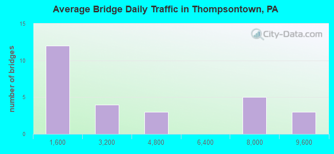
- 84,516Total average daily traffic
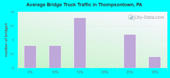
- 15,980Total average daily truck traffic
- National Bridge Inventory (NBI) Registered Bridges for Thompsontown
- No street view available for this location
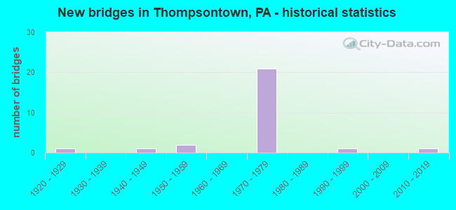
- New bridges - historical statistics
- 11920-1929
- 11940-1949
- 21950-1959
- 211970-1979
- 11990-1999
- 12010-2019
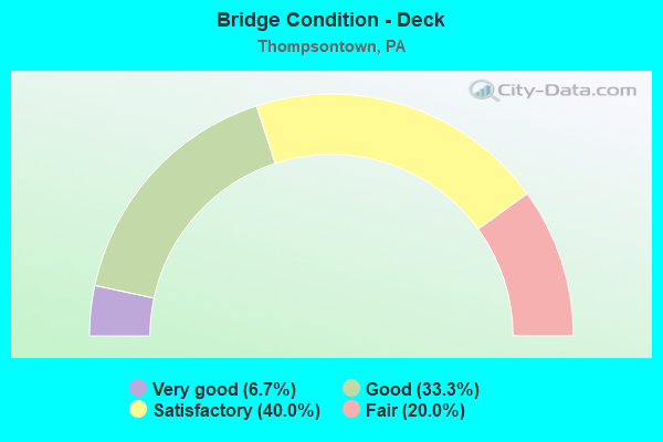
- Bridge Condition - Deck
- 6.7%Very good
- 33.3%Good
- 40.0%Satisfactory
- 20.0%Fair
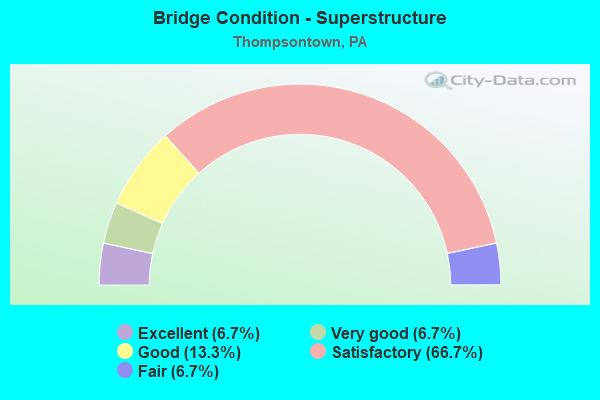
- Bridge Condition - Superstructure
- 6.7%Excellent
- 6.7%Very good
- 13.3%Good
- 66.7%Satisfactory
- 6.7%Fair
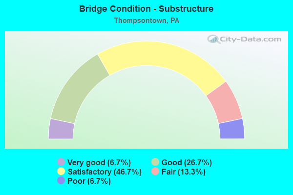
- Bridge Condition - Substructure
- 6.7%Very good
- 26.7%Good
- 46.7%Satisfactory
- 13.3%Fair
- 6.7%Poor
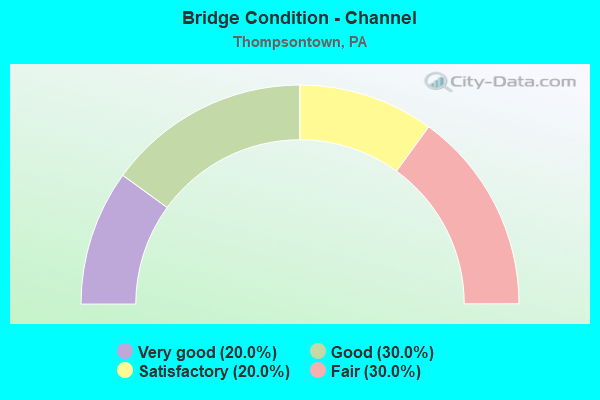
- Bridge Condition - Channel
- 20.0%Very good
- 30.0%Good
- 20.0%Satisfactory
- 30.0%Fair
Find on map >> Show street view
Structure Number: 1994, Location: 2 MI W THOMPSONTOWN (Lat: 40.559997, Lng: -77.273967), Route carried "on" structure: US 22, Year Built: 1972, Year Reconstructed: 2001, Status: Open, Structure Length: 11.03m (36.19ft), Average Daily Traffic: 6,671 (year 2021), Truck Traffic: 25%, Average Future Daily Traffic: 9,979 (year 2041), Design Load: HS 20+Mod, Features Intersected: SR 2007 & LOCUST RUN
Minimum Vertical Clearance: 30+ m (98+ ft), Kilometerpoint: 23.902, Lanes on structure: 2, Lanes under structure: 2, Base Highway Network: Yes, Owner: State Highway Agency, Approaching Roadway Width: 11.6m (38.1ft), Material/Design: Steel continuous, Design/Construction: Stringer/Multi-beam, Number Of Spans In Main Unit: 3, Length of Maximum Span: 39.6m (129.9ft), Curb or Sidewalk Widths: Left: 0.2m (0.7ft), Right: 0.2m (0.7ft), Curb-To-Curb Width: 12.0m (39.4ft), Out-to-Out Width: 13.2m (43.3ft)
Condition: Deck: Satisfactory, Superstructure: Satisfactory, Substructure: Satisfactory, Channel: Very good, Operating Rating: 60.8 metric tons, Method Used To Determine Operating Rating: Load Factor (LF), Inventory Rating: 36.3 metric tons, Method Used To Determine Inventory Rating: Load Factor (LF), Structural Evaluation: Equal to present minimum criteria, Deck Geometry: Better than present minimum criteria, Underclear: Superior to present desirable criteria, Waterway Adequacy: Superior to present desirable criteria, Approach Roadway Alignment: Equal to present desirable criteria, Length Of Structure Improvement: 11.00m (36.09ft), Designated Inspection Frequency: Every 24 months, Inspection Date: August 2021, Bridge Improvement Cost: $81,000, Roadway Improvement Cost: $250,000, Total Project Cost: $1,089,000, Deck Structure Type: Concrete Cast-file-Place, Wearing Surface/Protective System: Wearing Surface: Latex Concrete
Find on map >> Show street view
Structure Number: 19941, Location: 2 MI W THOMPSONTOWN (Lat: 40.560456, Lng: -77.274225), Route carried "on" structure: US 22, Year Built: 1972, Year Reconstructed: 2001, Status: Open, Structure Length: 11.80m (38.71ft), Average Daily Traffic: 7,021 (year 2021), Truck Traffic: 22%, Average Future Daily Traffic: 10,502 (year 2041), Design Load: HS 20+Mod, Features Intersected: SR 2007 & LOCUST RUN
Minimum Vertical Clearance: 30+ m (98+ ft), Kilometerpoint: 23.838, Lanes on structure: 2, Lanes under structure: 2, Base Highway Network: Yes, Owner: State Highway Agency, Approaching Roadway Width: 11.6m (38.1ft), Material/Design: Steel continuous, Design/Construction: Stringer/Multi-beam, Number Of Spans In Main Unit: 3, Length of Maximum Span: 39.6m (129.9ft), Curb or Sidewalk Widths: Left: 0.2m (0.7ft), Right: 0.2m (0.7ft), Curb-To-Curb Width: 12.0m (39.4ft), Out-to-Out Width: 13.2m (43.3ft)
Condition: Deck: Fair, Superstructure: Satisfactory, Substructure: Satisfactory, Channel: Very good, Operating Rating: 59.9 metric tons, Method Used To Determine Operating Rating: Load Factor (LF), Inventory Rating: 35.4 metric tons, Method Used To Determine Inventory Rating: Load Factor (LF), Structural Evaluation: Equal to present minimum criteria, Deck Geometry: Better than present minimum criteria, Underclear: Superior to present desirable criteria, Waterway Adequacy: Superior to present desirable criteria, Approach Roadway Alignment: Equal to present desirable criteria, Length Of Structure Improvement: 11.80m (38.71ft), Designated Inspection Frequency: Every 24 months, Inspection Date: August 2021, Bridge Improvement Cost: $51,000, Roadway Improvement Cost: $250,000, Total Project Cost: $687,000, Deck Structure Type: Concrete Cast-file-Place, Wearing Surface/Protective System: Wearing Surface: Epoxy Overlay
Find on map >> Show street view
Structure Number: 19943, Location: 1 MI W THOMPSONTOWN (Lat: 40.566522, Lng: -77.250614), Route carried "on" structure: US 22, Year Built: 1972, Year Reconstructed: 2001, Status: Open, Structure Length: 3.23m (10.60ft), Average Daily Traffic: 6,671 (year 2021), Truck Traffic: 25%, Average Future Daily Traffic: 9,979 (year 2041), Design Load: HS 20+Mod, Features Intersected: SR 2009
Minimum Vertical Clearance: 30+ m (98+ ft), Kilometerpoint: 26.160, Lanes on structure: 2, Lanes under structure: 2, Base Highway Network: Yes, Owner: State Highway Agency, Approaching Roadway Width: 11.6m (38.1ft), Material/Design: Prestressed concrete, Design/Construction: Stringer/Multi-beam, Number Of Spans In Main Unit: 1, Length of Maximum Span: 31.1m (102.0ft), Curb or Sidewalk Widths: Left: 0.2m (0.7ft), Right: 0.2m (0.7ft), Curb-To-Curb Width: 12.0m (39.4ft), Out-to-Out Width: 13.2m (43.3ft)
Condition: Deck: Good, Superstructure: Good, Substructure: Satisfactory, Operating Rating: 91.6 metric tons, Method Used To Determine Operating Rating: Load Factor (LF), Inventory Rating: 26.3 metric tons, Method Used To Determine Inventory Rating: Load Factor (LF), Structural Evaluation: Equal to present minimum criteria, Deck Geometry: Better than present minimum criteria, Underclear: Superior to present desirable criteria, Approach Roadway Alignment: Equal to present desirable criteria, Length Of Structure Improvement: 3.20m (10.50ft), Designated Inspection Frequency: Every 24 months, Inspection Date: August 2021, Deck Structure Type: Concrete Cast-file-Place, Wearing Surface/Protective System: Wearing Surface: Epoxy Overlay
Find on map >> Show street view
Structure Number: 19944, Location: 1 MI W THOMPSONTOWN (Lat: 40.566939, Lng: -77.250900), Route carried "on" structure: US 22, Year Built: 1972, Year Reconstructed: 2001, Status: Open, Structure Length: 2.50m (8.20ft), Average Daily Traffic: 7,021 (year 2021), Truck Traffic: 22%, Average Future Daily Traffic: 10,502 (year 2041), Design Load: HS 20+Mod, Features Intersected: SR 2009
Minimum Vertical Clearance: 30+ m (98+ ft), Kilometerpoint: 26.094, Lanes on structure: 2, Lanes under structure: 2, Base Highway Network: Yes, Owner: State Highway Agency, Approaching Roadway Width: 11.6m (38.1ft), Material/Design: Prestressed concrete, Design/Construction: Stringer/Multi-beam, Number Of Spans In Main Unit: 1, Length of Maximum Span: 24.1m (79.1ft), Curb or Sidewalk Widths: Left: 0.2m (0.7ft), Right: 0.2m (0.7ft), Curb-To-Curb Width: 12.0m (39.4ft), Out-to-Out Width: 13.2m (43.3ft)
Condition: Deck: Satisfactory, Superstructure: Satisfactory, Substructure: Satisfactory, Operating Rating: 79.8 metric tons, Method Used To Determine Operating Rating: Load Factor (LF), Inventory Rating: 33.6 metric tons, Method Used To Determine Inventory Rating: Load Factor (LF), Structural Evaluation: Equal to present minimum criteria, Deck Geometry: Better than present minimum criteria, Underclear: Equal to present minimum criteria, Approach Roadway Alignment: Better than present minimum criteria, Length Of Structure Improvement: 2.50m (8.20ft), Designated Inspection Frequency: Every 24 months, Inspection Date: August 2021, Deck Structure Type: Concrete Cast-file-Place, Wearing Surface/Protective System: Wearing Surface: Epoxy Overlay
Find on map >> Show street view
Structure Number: 19946, Location: THOMPSONTOWN (Lat: 40.569892, Lng: -77.235089), Route carried "on" structure: US 22, Year Built: 1972, Year Reconstructed: 2001, Status: Open, Structure Length: 12.98m (42.59ft), Average Daily Traffic: 7,021 (year 2021), Truck Traffic: 22%, Average Future Daily Traffic: 10,502 (year 2041), Design Load: HS 20+Mod, Features Intersected: SR 333-PA 333;DELAWARE C
Minimum Vertical Clearance: 30+ m (98+ ft), Kilometerpoint: 27.616, Lanes on structure: 2, Lanes under structure: 8, Base Highway Network: Yes, Owner: State Highway Agency, Approaching Roadway Width: 11.6m (38.1ft), Skew: 3 degrees, Material/Design: Steel continuous, Design/Construction: Stringer/Multi-beam, Number Of Spans In Main Unit: 4, Length of Maximum Span: 36.9m (121.1ft), Curb or Sidewalk Widths: Left: 0.2m (0.7ft), Right: 0.2m (0.7ft), Curb-To-Curb Width: 12.0m (39.4ft), Out-to-Out Width: 13.2m (43.3ft)
Condition: Deck: Satisfactory, Superstructure: Satisfactory, Substructure: Satisfactory, Channel: Good, Operating Rating: 56.2 metric tons, Method Used To Determine Operating Rating: Load Factor (LF), Inventory Rating: 33.6 metric tons, Method Used To Determine Inventory Rating: Load Factor (LF), Structural Evaluation: Equal to present minimum criteria, Deck Geometry: Better than present minimum criteria, Underclear: Equal to present minimum criteria, Waterway Adequacy: Superior to present desirable criteria, Approach Roadway Alignment: Equal to present desirable criteria, Length Of Structure Improvement: 13.00m (42.65ft), Designated Inspection Frequency: Every 24 months, Inspection Date: August 2021, Deck Structure Type: Concrete Cast-file-Place, Wearing Surface/Protective System: Wearing Surface: Epoxy Overlay
Find on map >> Show street view
Structure Number: 19948, Location: THOMPSONTOWN (Lat: 40.569350, Lng: -77.226636), Route carried "on" structure: US 22, Year Built: 1972, Year Reconstructed: 2001, Status: Open, Structure Length: 2.99m (9.81ft), Average Daily Traffic: 8,314 (year 2021), Truck Traffic: 21%, Average Future Daily Traffic: 8,790 (year 2041), Design Load: HS 20+Mod, Features Intersected: TOWNSHIP ROAD 466
Minimum Vertical Clearance: 30+ m (98+ ft), Kilometerpoint: 28.450, Lanes on structure: 3, Lanes under structure: 2, Base Highway Network: Yes, Owner: State Highway Agency, Approaching Roadway Width: 11.6m (38.1ft), Material/Design: Prestressed concrete, Design/Construction: Box Beam or Girders - Single/Spread, Number Of Spans In Main Unit: 3, Length of Maximum Span: 15.5m (50.9ft), Curb or Sidewalk Widths: Left: 0.2m (0.7ft), Right: 0.2m (0.7ft), Curb-To-Curb Width: 16.4m (53.8ft), Out-to-Out Width: 17.7m (58.1ft)
Condition: Deck: Satisfactory, Superstructure: Satisfactory, Substructure: Satisfactory, Operating Rating: 58.1 metric tons, Method Used To Determine Operating Rating: Load Factor (LF), Inventory Rating: 29.9 metric tons, Method Used To Determine Inventory Rating: Load Factor (LF), Structural Evaluation: Equal to present minimum criteria, Deck Geometry: Better than present minimum criteria, Underclear: Equal to present minimum criteria, Approach Roadway Alignment: Equal to present desirable criteria, Length Of Structure Improvement: 3.00m (9.84ft), Designated Inspection Frequency: Every 24 months, Inspection Date: August 2021, Bridge Improvement Cost: $34,000, Roadway Improvement Cost: $250,000, Total Project Cost: $457,000, Deck Structure Type: Concrete Cast-file-Place, Wearing Surface/Protective System: Wearing Surface: Epoxy Overlay
Find on map >> Show street view
Structure Number: 19949, Location: THOMPSONTOWN (Lat: 40.569644, Lng: -77.226694), Route carried "on" structure: US 22, Year Built: 1972, Year Reconstructed: 2001, Status: Open, Structure Length: 3.84m (12.60ft), Average Daily Traffic: 8,835 (year 2021), Truck Traffic: 23%, Average Future Daily Traffic: 10,702 (year 2041), Design Load: HS 20+Mod, Features Intersected: TOWNSHIP ROAD 466
Minimum Vertical Clearance: 30+ m (98+ ft), Kilometerpoint: 28.403, Lanes on structure: 2, Lanes under structure: 2, Base Highway Network: Yes, Owner: State Highway Agency, Approaching Roadway Width: 11.6m (38.1ft), Material/Design: Prestressed concrete, Design/Construction: Box Beam or Girders - Single/Spread, Number Of Spans In Main Unit: 3, Length of Maximum Span: 15.5m (50.9ft), Curb or Sidewalk Widths: Left: 0.2m (0.7ft), Right: 0.2m (0.7ft), Curb-To-Curb Width: 12.0m (39.4ft), Out-to-Out Width: 13.2m (43.3ft)
Condition: Deck: Fair, Superstructure: Satisfactory, Substructure: Good, Operating Rating: 65.3 metric tons, Method Used To Determine Operating Rating: Load Factor (LF), Inventory Rating: 31.8 metric tons, Method Used To Determine Inventory Rating: Load Factor (LF), Structural Evaluation: Equal to present minimum criteria, Deck Geometry: Better than present minimum criteria, Underclear: Meets minimum limits, Approach Roadway Alignment: Equal to present desirable criteria, Length Of Structure Improvement: 3.80m (12.47ft), Designated Inspection Frequency: Every 24 months, Inspection Date: August 2021, Bridge Improvement Cost: $33,000, Roadway Improvement Cost: $250,000, Total Project Cost: $450,000, Deck Structure Type: Concrete Cast-file-Place, Wearing Surface/Protective System: Wearing Surface: Epoxy Overlay
Find on map >> Show street view
Structure Number: 19953, Location: 1 MI SE THOMPSONTOWN (Lat: 40.569950, Lng: -77.204214), Route carried "on" structure: US 22, Year Built: 1972, Year Reconstructed: 2001, Status: Open, Structure Length: 5.06m (16.60ft), Average Daily Traffic: 8,835 (year 2021), Truck Traffic: 23%, Average Future Daily Traffic: 10,702 (year 2041), Design Load: HS 20+Mod, Features Intersected: TOWNSHIP ROAD 554
Minimum Vertical Clearance: 30+ m (98+ ft), Kilometerpoint: 30.660, Lanes on structure: 2, Lanes under structure: 2, Base Highway Network: Yes, Owner: State Highway Agency, Approaching Roadway Width: 11.6m (38.1ft), Skew: 4 degrees, Material/Design: Prestressed concrete, Design/Construction: Stringer/Multi-beam, Number Of Spans In Main Unit: 3, Length of Maximum Span: 24.4m (80.1ft), Curb or Sidewalk Widths: Left: 0.2m (0.7ft), Right: 0.2m (0.7ft), Curb-To-Curb Width: 12.0m (39.4ft), Out-to-Out Width: 13.2m (43.3ft)
Condition: Deck: Good, Superstructure: Satisfactory, Substructure: Fair, Operating Rating: 74.4 metric tons, Method Used To Determine Operating Rating: Load Factor (LF), Inventory Rating: 27.2 metric tons, Method Used To Determine Inventory Rating: Load Factor (LF), Structural Evaluation: Somewhat better than minimum adequacy, Deck Geometry: Better than present minimum criteria, Underclear: Equal to present minimum criteria, Approach Roadway Alignment: Equal to present desirable criteria, Length Of Structure Improvement: 5.10m (16.73ft), Designated Inspection Frequency: Every 24 months, Inspection Date: August 2021, Bridge Improvement Cost: $36,000, Roadway Improvement Cost: $250,000, Total Project Cost: $487,000, Deck Structure Type: Concrete Cast-file-Place, Wearing Surface/Protective System: Wearing Surface: Epoxy Overlay
Find on map >> Show street view
Structure Number: 20082, Location: THOMPSONTOWN STATION (Lat: 40.561972, Lng: -77.256372), Route carried "on" structure: State highway 333, Year Built: 1994, Status: Open, Structure Length: 24.63m (80.81ft), Average Daily Traffic: 256 (year 2020), Truck Traffic: 8%, Average Future Daily Traffic: 245 (year 2041), Design Load: HS 25 or greater, Features Intersected: JUNIATA R/NORFOLK & S
Minimum Vertical Clearance: 30+ m (98+ ft), Kilometerpoint: 32.805, Lanes on structure: 2, Owner: State Highway Agency, Approaching Roadway Width: 10.4m (34.1ft), Material/Design: Prestressed concrete continuous, Design/Construction: Stringer/Multi-beam, Number Of Spans In Main Unit: 5, Number Of Approach Spans: 1, Length of Maximum Span: 42.7m (140.1ft), Curb or Sidewalk Widths: Left: 0.2m (0.7ft), Right: 0.2m (0.7ft), Curb-To-Curb Width: 9.8m (32.2ft), Out-to-Out Width: 10.8m (35.4ft)
Condition: Deck: Good, Superstructure: Satisfactory, Substructure: Good, Channel: Good, Inventory Rating: 52.6 metric tons, Method Used To Determine Inventory Rating: Load Factor (LF), Structural Evaluation: Equal to present minimum criteria, Deck Geometry: Better than present minimum criteria, Underclear: High priority of corrective action, Waterway Adequacy: Superior to present desirable criteria, Approach Roadway Alignment: Somewhat better than minimum adequacy, Length Of Structure Improvement: 24.60m (80.71ft), Designated Inspection Frequency: Every 24 months, Underwater Inspection Frequency: Every 60 months, Inspection Date: October 2021, Underwater Inspection Date: April 2021, Deck Structure Type: Concrete Cast-file-Place, Wearing Surface/Protective System: Wearing Surface: Epoxy Overlay, Deck Protection: Epoxy Coated Reinforcing
Find on map >> Show street view
Structure Number: 20083, Location: THOMPSONTOWN BORO (Lat: 40.564781, Lng: -77.234031), Route carried "on" structure: State highway 333, Year Built: 1928, Status: Open, Structure Length: 1.43m (4.69ft), Average Daily Traffic: 3,918 (year 2021), Truck Traffic: 10%, Average Future Daily Traffic: 5,047 (year 2041), Design Load: H 15, Features Intersected: DELAWARE CREEK
Minimum Vertical Clearance: 30+ m (98+ ft), Kilometerpoint: 34.781, Lanes on structure: 2, Owner: State Highway Agency, Approaching Roadway Width: 9.8m (32.2ft), Skew: 1 degrees, Material/Design: Concrete, Design/Construction: Tee Beam, Number Of Spans In Main Unit: 1, Length of Maximum Span: 13.7m (44.9ft), Curb or Sidewalk Widths: Left: 1.5m (4.9ft), Right: 1.5m (4.9ft), Curb-To-Curb Width: 7.3m (24.0ft), Out-to-Out Width: 11.3m (37.1ft)
Condition: Deck: Fair, Superstructure: Fair, Substructure: Satisfactory, Channel: Fair, Operating Rating: 66.2 metric tons, Method Used To Determine Operating Rating: Field evaluation and documented engineering judgment, Inventory Rating: 39.9 metric tons, Method Used To Determine Inventory Rating: Field evaluation and documented engineering judgment, Structural Evaluation: Somewhat better than minimum adequacy, Deck Geometry: High priority of replacement, Waterway Adequacy: Better than present minimum criteria, Approach Roadway Alignment: Equal to present desirable criteria, Length Of Structure Improvement: 1.40m (4.59ft), Designated Inspection Frequency: Every 24 months, Inspection Date: October 2021, Bridge Improvement Cost: $38,000, Roadway Improvement Cost: $250,000, Total Project Cost: $515,000, Deck Structure Type: Concrete Cast-file-Place, Wearing Surface/Protective System: Wearing Surface: Bituminous, Membrane: Preformed Fabric
Find on map >> Show street view
Structure Number: 20085, Location: THOMPSONTOWN (Lat: 40.573553, Lng: -77.234842), Route carried "on" structure: State highway 333, Year Built: 1952, Status: Open, Structure Length: 1.77m (5.81ft), Average Daily Traffic: 3,942 (year 2021), Truck Traffic: 10%, Average Future Daily Traffic: 4,844 (year 2041), Design Load: HS 20, Features Intersected: DELAWARE CREEK
Minimum Vertical Clearance: 30+ m (98+ ft), Kilometerpoint: 35.940, Lanes on structure: 2, Owner: State Highway Agency, Approaching Roadway Width: 7.6m (24.9ft), Material/Design: Concrete, Design/Construction: Tee Beam, Number Of Spans In Main Unit: 2, Length of Maximum Span: 8.2m (26.9ft), Curb or Sidewalk Widths: Left: 0.5m (1.6ft), Right: 0.5m (1.6ft), Curb-To-Curb Width: 11.0m (36.1ft), Out-to-Out Width: 12.1m (39.7ft)
Condition: Deck: Satisfactory, Superstructure: Satisfactory, Substructure: Fair, Channel: Satisfactory, Operating Rating: 68.9 metric tons, Method Used To Determine Operating Rating: Load Factor (LF), Inventory Rating: 40.8 metric tons, Method Used To Determine Inventory Rating: Load Factor (LF), Structural Evaluation: Somewhat better than minimum adequacy, Deck Geometry: Somewhat better than minimum adequacy, Waterway Adequacy: Equal to present minimum criteria, Approach Roadway Alignment: Equal to present desirable criteria, Length Of Structure Improvement: 1.80m (5.91ft), Designated Inspection Frequency: Every 24 months, Inspection Date: October 2021, Bridge Improvement Cost: $29,000, Roadway Improvement Cost: $250,000, Total Project Cost: $386,000, Deck Structure Type: Concrete Cast-file-Place, Wearing Surface/Protective System: Wearing Surface: Bituminous
Find on map >> Show street view
Structure Number: 20088, Location: 1 MI N THOMPSONTOWN (Lat: 40.585719, Lng: -77.236483), Route carried "on" structure: State highway 333, Year Built: 1952, Status: Open, Structure Length: 2.07m (6.79ft), Average Daily Traffic: 3,942 (year 2021), Truck Traffic: 10%, Average Future Daily Traffic: 4,844 (year 2041), Design Load: HS 20, Features Intersected: DELAWARE CREEK
Minimum Vertical Clearance: 30+ m (98+ ft), Kilometerpoint: 37.678, Lanes on structure: 2, Owner: State Highway Agency, Approaching Roadway Width: 7.9m (25.9ft), Skew: 3 degrees, Material/Design: Concrete, Design/Construction: Tee Beam, Number Of Spans In Main Unit: 2, Length of Maximum Span: 9.8m (32.2ft), Curb or Sidewalk Widths: Left: 0.4m (1.3ft), Right: 0.4m (1.3ft), Curb-To-Curb Width: 11.0m (36.1ft), Out-to-Out Width: 12.1m (39.7ft)
Condition: Deck: Satisfactory, Superstructure: Satisfactory, Substructure: Poor, Channel: Fair, Operating Rating: 69.9 metric tons, Method Used To Determine Operating Rating: Load Factor (LF), Inventory Rating: 42.6 metric tons, Method Used To Determine Inventory Rating: Load Factor (LF), Structural Evaluation: Meets minimum limits, Deck Geometry: Somewhat better than minimum adequacy, Waterway Adequacy: Equal to present minimum criteria, Approach Roadway Alignment: Equal to present desirable criteria, Length Of Structure Improvement: 2.10m (6.89ft), Designated Inspection Frequency: Every 24 months, Inspection Date: September 2021, Bridge Improvement Cost: $29,000, Roadway Improvement Cost: $250,000, Total Project Cost: $393,000, Deck Structure Type: Concrete Cast-file-Place, Wearing Surface/Protective System: Wearing Surface: Bituminous
Find on map >> Show street view
Structure Number: 20359, Location: THOMPSONTOWN (Lat: 40.570744, Lng: -77.236333), Route carried "on" structure: Ramp State highway , Year Built: 1974, Status: Open, Structure Length: 1.86m (6.10ft), Average Daily Traffic: 357 (year 2022), Truck Traffic: 8%, Average Future Daily Traffic: 258 (year 2041), Design Load: HS 20, Features Intersected: DELAWARE CREEK, Facility Carried by Structure: SR 8008-US 22 RAMP
Minimum Vertical Clearance: 30+ m (98+ ft), Kilometerpoint: 0.000, Lanes on structure: 1, Owner: State Highway Agency, Approaching Roadway Width: 7.9m (25.9ft), Skew: 2 degrees, Material/Design: Prestressed concrete, Design/Construction: Box Beam or Girders - Single/Spread, Number Of Spans In Main Unit: 1, Length of Maximum Span: 17.7m (58.1ft), Curb or Sidewalk Widths: Left: 0.2m (0.7ft), Right: 0.2m (0.7ft), Curb-To-Curb Width: 9.2m (30.2ft), Out-to-Out Width: 10.5m (34.4ft)
Condition: Deck: Good, Superstructure: Good, Substructure: Good, Channel: Good, Operating Rating: 77.1 metric tons, Method Used To Determine Operating Rating: Load Factor (LF), Inventory Rating: 43.5 metric tons, Method Used To Determine Inventory Rating: Load Factor (LF), Structural Evaluation: Better than present minimum criteria, Deck Geometry: Superior to present desirable criteria, Waterway Adequacy: Equal to present desirable criteria, Approach Roadway Alignment: Equal to present desirable criteria, Length Of Structure Improvement: 1.90m (6.23ft), Designated Inspection Frequency: Every 24 months, Inspection Date: August 2021, Deck Structure Type: Concrete Cast-file-Place, Wearing Surface/Protective System: Wearing Surface: Epoxy Overlay
Find on map >> Show street view
Structure Number: 29692, Location: 1 MI.S.OF DONNALLYS MILL (Lat: 40.508031, Lng: -77.230842), Route carried "on" structure: State highway , Year Built: 1940, Year Reconstructed: 1995, Status: Open, Structure Length: 1.19m (3.90ft), Average Daily Traffic: 517 (year 2022), Truck Traffic: 3%, Average Future Daily Traffic: 814 (year 2032), Design Load: HS 25 or greater, Features Intersected: BUCKWHEAT RUN, Facility Carried by Structure: SR 4007
Minimum Vertical Clearance: 30+ m (98+ ft), Kilometerpoint: 5.319, Lanes on structure: 2, Owner: State Highway Agency, Approaching Roadway Width: 7.3m (24.0ft), Skew: 3 degrees, Material/Design: Prestressed concrete, Design/Construction: Box Beam or Girders - Single/Spread, Number Of Spans In Main Unit: 1, Length of Maximum Span: 11.0m (36.1ft), Curb or Sidewalk Widths: Left: 0.2m (0.7ft), Right: 0.2m (0.7ft), Curb-To-Curb Width: 7.3m (24.0ft), Out-to-Out Width: 8.4m (27.6ft)
Condition: Deck: Good, Superstructure: Very good, Substructure: Good, Channel: Fair, Operating Rating: 89.8 metric tons, Method Used To Determine Operating Rating: Load Factor (LF), Inventory Rating: 44.5 metric tons, Method Used To Determine Inventory Rating: Load Factor (LF), Structural Evaluation: Better than present minimum criteria, Deck Geometry: Meets minimum limits, Waterway Adequacy: Better than present minimum criteria, Approach Roadway Alignment: Somewhat better than minimum adequacy, Length Of Structure Improvement: 1.80m (5.91ft), Designated Inspection Frequency: Every 24 months, Inspection Date: Febuary 2021, Deck Structure Type: Concrete Cast-file-Place, Wearing Surface/Protective System: Wearing Surface: Monolithic Concrete, Deck Protection: Epoxy Coated Reinforcing
Find on map >> Show street view
Structure Number: 53969, Location: DONNALLY'S MILLS (Lat: 40.516069, Lng: -77.236292), Route carried "on" structure: State highway , Year Built: 2017, Status: Open, Structure Length: 1.74m (5.71ft), Average Daily Traffic: 517 (year 2022), Truck Traffic: 3%, Average Future Daily Traffic: 814 (year 2032), Design Load: HL 93, Features Intersected: RACCOON CREEK, Facility Carried by Structure: CREEK RD
Minimum Vertical Clearance: 30+ m (98+ ft), Kilometerpoint: 5.919, Lanes on structure: 2, Owner: State Highway Agency, Maintenance Responsibility: Private, Approaching Roadway Width: 6.1m (20.0ft), Material/Design: Prestressed concrete, Design/Construction: Box Beam or Girders - Single/Spread, Number Of Spans In Main Unit: 1, Length of Maximum Span: 16.2m (53.1ft), Curb-To-Curb Width: 9.4m (30.8ft), Out-to-Out Width: 10.1m (33.1ft)
Condition: Deck: Very good, Superstructure: Excellent, Substructure: Very good, Channel: Satisfactory, Operating Rating: 60.6 metric tons, Method Used To Determine Operating Rating: Assigned ratings based on Load and Resistance Factor Design (LRFD) reported by rating factor (RF) using HL93 loadings, Inventory Rating: 46.7 metric tons, Method Used To Determine Inventory Rating: Assigned ratings based on Load and Resistance Factor Design (LRFD) reported by rating factor (RF) using HL93 loadings, Structural Evaluation: Equal to present desirable criteria, Deck Geometry: Equal to present minimum criteria, Waterway Adequacy: Equal to present desirable criteria, Approach Roadway Alignment: Equal to present desirable criteria, Designated Inspection Frequency: Every 24 months, Inspection Date: September 2021, Deck Structure Type: Concrete Cast-file-Place, Wearing Surface/Protective System: Wearing Surface: Integral Concrete, Deck Protection: Epoxy Coated Reinforcing
Find on map >> Show street view
Structure Number: 1994, Location: 2 MI W THOMPSONTOWN (Lat: 40.559997, Lng: -77.273967), Route carried "under" structure: State highway , Year Built: 1972, Structure Length: 0. m, Average Daily Traffic: 401 (year 2022), Truck Traffic: 4%, Features Intersected: SR 2007 & LOCUST RUN, Facility Carried by Structure: SR 22-US 22
Minimum Vertical Clearance: 17.65m (57.91ft), Kilometerpoint: 0.000, Lanes on structure: 2, Lanes under structure: 2, Material/Design: Steel continuous, Design/Construction: Stringer/Multi-beam, Length of Maximum Span: 39.6m (129.9ft)
Find on map >> Show street view
Structure Number: 19941, Location: 2 MI W THOMPSONTOWN (Lat: 40.560456, Lng: -77.274225), Route carried "under" structure: State highway , Year Built: 1972, Structure Length: 0. m, Average Daily Traffic: 401 (year 2022), Truck Traffic: 4%, Features Intersected: SR 2007 & LOCUST RUN, Facility Carried by Structure: SR 22-US 22
Minimum Vertical Clearance: 17.65m (57.91ft), Kilometerpoint: 0.000, Lanes on structure: 2, Lanes under structure: 2, Material/Design: Steel continuous, Design/Construction: Stringer/Multi-beam, Length of Maximum Span: 39.6m (129.9ft)
Find on map >> Show street view
Structure Number: 19943, Location: 1 MI W THOMPSONTOWN (Lat: 40.566522, Lng: -77.250614), Route carried "under" structure: State highway , Year Built: 1972, Structure Length: 0. m, Average Daily Traffic: 756 (year 2020), Truck Traffic: 6%, Features Intersected: SR 2009, Facility Carried by Structure: SR 22-US 22
Minimum Vertical Clearance: 7.25m (23.79ft), Kilometerpoint: 1.241, Lanes on structure: 2, Lanes under structure: 2, Material/Design: Prestressed concrete, Design/Construction: Stringer/Multi-beam, Length of Maximum Span: 31.1m (102.0ft)
Find on map >> Show street view
Structure Number: 19944, Location: 1 MI W THOMPSONTOWN (Lat: 40.566939, Lng: -77.250900), Route carried "under" structure: State highway , Year Built: 1972, Structure Length: 0. m, Average Daily Traffic: 756 (year 2020), Truck Traffic: 6%, Features Intersected: SR 2009, Facility Carried by Structure: SR 22-US 22
Minimum Vertical Clearance: 4.59m (15.06ft), Kilometerpoint: 1.241, Lanes on structure: 2, Lanes under structure: 2, Material/Design: Prestressed concrete, Design/Construction: Stringer/Multi-beam, Length of Maximum Span: 24.1m (79.1ft)
Find on map >> Show street view
Structure Number: 19945, Location: THOMPSONTOWN (Lat: 40.569458, Lng: -77.234964), Route carried "under" structure: State highway 333, Year Built: 1972, Structure Length: 0. m, Average Daily Traffic: 1,971 (year 2021), Truck Traffic: 10%, Features Intersected: SR 333-PA 333;DELAWARE C, Facility Carried by Structure: SR 22-US 22
Minimum Vertical Clearance: 11.12m (36.48ft), Kilometerpoint: 35.056, Lanes on structure: 2, Lanes under structure: 4, Material/Design: Steel continuous, Design/Construction: Stringer/Multi-beam, Length of Maximum Span: 36.9m (121.1ft)
Find on map >> Show street view
Structure Number: 19945, Location: THOMPSONTOWN (Lat: 40.569458, Lng: -77.234964), Route carried "under" structure: State highway 333, Year Built: 1972, Structure Length: 0. m, Average Daily Traffic: 1,971 (year 2021), Truck Traffic: 10%, Features Intersected: SR 333-PA 333;DELAWARE C, Facility Carried by Structure: SR 22-US 22
Minimum Vertical Clearance: 11.08m (36.35ft), Kilometerpoint: 35.056, Lanes on structure: 2, Lanes under structure: 4, Material/Design: Steel continuous, Design/Construction: Stringer/Multi-beam, Length of Maximum Span: 36.9m (121.1ft)
Find on map >> Show street view
Structure Number: 19946, Location: THOMPSONTOWN (Lat: 40.569892, Lng: -77.235089), Route carried "under" structure: State highway 333, Year Built: 1972, Structure Length: 0. m, Average Daily Traffic: 1,971 (year 2021), Truck Traffic: 10%, Features Intersected: SR 333-PA 333;DELAWARE C, Facility Carried by Structure: SR 22-US 22
Minimum Vertical Clearance: 12.42m (40.75ft), Kilometerpoint: 35.056, Lanes on structure: 2, Lanes under structure: 4, Material/Design: Steel continuous, Design/Construction: Stringer/Multi-beam, Length of Maximum Span: 36.9m (121.1ft)
Find on map >> Show street view
Structure Number: 19946, Location: THOMPSONTOWN (Lat: 40.569892, Lng: -77.235089), Route carried "under" structure: State highway 333, Year Built: 1972, Structure Length: 0. m, Average Daily Traffic: 1,971 (year 2021), Truck Traffic: 10%, Features Intersected: SR 333-PA 333;DELAWARE C, Facility Carried by Structure: SR 22-US 22
Minimum Vertical Clearance: 12.04m (39.50ft), Kilometerpoint: 35.056, Lanes on structure: 2, Lanes under structure: 4, Material/Design: Steel continuous, Design/Construction: Stringer/Multi-beam, Length of Maximum Span: 36.9m (121.1ft)
Find on map >> Show street view
Structure Number: 19948, Location: THOMPSONTOWN (Lat: 40.569350, Lng: -77.226636), Route carried "under" structure: City street , Year Built: 1972, Structure Length: 0. m, Average Daily Traffic: 50 (year 2004), Features Intersected: TOWNSHIP ROAD 466, Facility Carried by Structure: SR 22-US 22
Minimum Vertical Clearance: 4.54m (14.90ft), Kilometerpoint: 0.000, Lanes on structure: 3, Lanes under structure: 2, Material/Design: Prestressed concrete, Design/Construction: Box Beam or Girders - Single/Spread, Length of Maximum Span: 15.5m (50.9ft)
Find on map >> Show street view
Structure Number: 19949, Location: THOMPSONTOWN (Lat: 40.569644, Lng: -77.226694), Route carried "under" structure: City street , Year Built: 1972, Structure Length: 0. m, Average Daily Traffic: 50 (year 2004), Features Intersected: TOWNSHIP ROAD 466, Facility Carried by Structure: SR 22-US 22
Minimum Vertical Clearance: 6.58m (21.59ft), Kilometerpoint: 0.000, Lanes on structure: 2, Lanes under structure: 2, Material/Design: Prestressed concrete, Design/Construction: Box Beam or Girders - Single/Spread, Length of Maximum Span: 15.5m (50.9ft)
Find on map >> Show street view
Structure Number: 1995, Location: 1 MI E THOMPSONTOWN (Lat: 40.569867, Lng: -77.204681), Route carried "under" structure: City street , Year Built: 1972, Structure Length: 0. m, Average Daily Traffic: 190 (year 1985), Truck Traffic: 10%, Features Intersected: TOWNSHIP ROAD 554, Facility Carried by Structure: SR 22-US 22
Minimum Vertical Clearance: 4.44m (14.57ft), Kilometerpoint: 0.000, Lanes on structure: 2, Lanes under structure: 2, Material/Design: Prestressed concrete, Design/Construction: Stringer/Multi-beam, Length of Maximum Span: 22.6m (74.1ft)
Find on map >> Show street view
Structure Number: 19953, Location: 1 MI SE THOMPSONTOWN (Lat: 40.569950, Lng: -77.204214), Route carried "under" structure: City street , Year Built: 1972, Structure Length: 0. m, Average Daily Traffic: 190 (year 1985), Truck Traffic: 10%, Features Intersected: TOWNSHIP ROAD 554, Facility Carried by Structure: SR 22-US 22
Minimum Vertical Clearance: 4.65m (15.26ft), Kilometerpoint: 0.000, Lanes on structure: 2, Lanes under structure: 2, Material/Design: Prestressed concrete, Design/Construction: Stringer/Multi-beam, Length of Maximum Span: 24.4m (80.1ft)