Bridge Statistics for Tiffin, Iowa (IA)
Condition, Traffic, Stress, Structural Evaluation, Project Costs
- National Bridge Inventory (NBI) Statistics
- 47Number of bridges
- 633ft / 193mTotal length
- 495,825Total average daily traffic
- 96,941Total average daily truck traffic
- National Bridge Inventory (NBI) Registered Bridges for Tiffin
- No street view available for this location
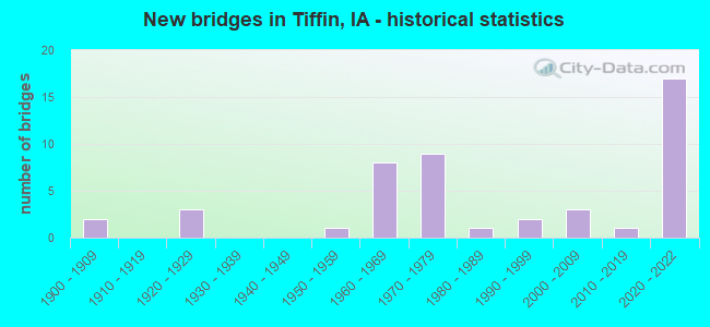
- New bridges - historical statistics
- 21900-1909
- 31920-1929
- 11950-1959
- 81960-1969
- 91970-1979
- 11980-1989
- 21990-1999
- 32000-2009
- 12010-2019
- 172020-2022


- Bridge Condition - Deck
- 42.3%Excellent
- 3.8%Very good
- 15.4%Good
- 30.8%Satisfactory
- 3.8%Fair
- 3.8%Serious

- Bridge Condition - Superstructure
- 42.3%Excellent
- 11.5%Very good
- 23.1%Good
- 7.7%Satisfactory
- 11.5%Fair
- 3.8%Imminent failure

- Bridge Condition - Substructure
- 42.3%Excellent
- 11.5%Very good
- 15.4%Good
- 23.1%Satisfactory
- 3.8%Fair
- 3.8%Serious

- Bridge Condition - Channel
- 9.5%Excellent
- 14.3%Good
- 61.9%Satisfactory
- 14.3%Fair

- Bridge Condition - Culverts
- 40.0%Good
- 50.0%Satisfactory
- 10.0%Fair
Find on map >> Show street view
Structure Number: 3146, Location: 3.1 MI. E OF JCT. SR W38 (Lat: 41.718361, Lng: -91.731869), Route carried "on" structure: US 6, Year Built: 1953, Status: Open, Structure Length: 0.70m (2.30ft), Average Daily Traffic: 3,390 (year 2020), Truck Traffic: 14%, Average Future Daily Traffic: 3,390 (year 2040), Design Load: H 20, Features Intersected: STREAM
Minimum Vertical Clearance: 30+ m (98+ ft), Kilometerpoint: 395.990, Lanes on structure: 2, Base Highway Network: Yes, Owner: State Highway Agency, Approaching Roadway Width: 14.0m (45.9ft), Skew: 2 degrees, Material/Design: Concrete continuous, Design/Construction: Culvert, Number Of Spans In Main Unit: 2, Length of Maximum Span: 3.0m (9.8ft)
Condition: Channel: Satisfactory, Culverts: Satisfactory, Operating Rating: 24.5 metric tons, Method Used To Determine Operating Rating: Field evaluation and documented engineering judgment, Inventory Rating: 18.1 metric tons, Method Used To Determine Inventory Rating: Field evaluation and documented engineering judgment, Structural Evaluation: Somewhat better than minimum adequacy, Waterway Adequacy: Equal to present desirable criteria, Approach Roadway Alignment: Equal to present desirable criteria, Designated Inspection Frequency: Every 24 months, Inspection Date: August 2020
Find on map >> Show street view
Structure Number: 3147, Location: 4.0 mi. E of Jct. SR W38. (Lat: 41.714719, Lng: -91.714997), Route carried "on" structure: US 6, Year Built: 1923, Year Reconstructed: 1960, Status: Open, Structure Length: 0.91m (2.99ft), Average Daily Traffic: 3,390 (year 2020), Truck Traffic: 14%, Average Future Daily Traffic: 3,390 (year 2040), Design Load: H 20, Features Intersected: STREAM
Minimum Vertical Clearance: 30+ m (98+ ft), Kilometerpoint: 397.469, Lanes on structure: 2, Base Highway Network: Yes, Owner: State Highway Agency, Approaching Roadway Width: 14.6m (47.9ft), Material/Design: Concrete continuous, Design/Construction: Culvert, Number Of Spans In Main Unit: 3, Length of Maximum Span: 3.0m (9.8ft)
Condition: Channel: Satisfactory, Culverts: Satisfactory, Operating Rating: 21.6 metric tons, Method Used To Determine Operating Rating: Field evaluation and documented engineering judgment, Inventory Rating: 12.6 metric tons, Method Used To Determine Inventory Rating: Field evaluation and documented engineering judgment, Structural Evaluation: Meets minimum limits, Waterway Adequacy: Better than present minimum criteria, Approach Roadway Alignment: Equal to present desirable criteria, Designated Inspection Frequency: Every 24 months, Inspection Date: September 2020
Find on map >> Show street view
Structure Number: 3148, Location: 4.1 mi. E of Jct. SR W-38 (Lat: 41.714333, Lng: -91.711400), Route carried "on" structure: US 6, Year Built: 1923, Year Reconstructed: 1960, Status: Open, Structure Length: 0.64m (2.10ft), Average Daily Traffic: 3,390 (year 2020), Truck Traffic: 14%, Average Future Daily Traffic: 3,390 (year 2040), Design Load: H 20, Features Intersected: PIG RUN CREEK
Minimum Vertical Clearance: 30+ m (98+ ft), Kilometerpoint: 397.772, Lanes on structure: 2, Base Highway Network: Yes, Owner: State Highway Agency, Approaching Roadway Width: 14.6m (47.9ft), Material/Design: Concrete continuous, Design/Construction: Culvert, Number Of Spans In Main Unit: 2, Length of Maximum Span: 3.0m (9.8ft)
Condition: Channel: Satisfactory, Culverts: Satisfactory, Operating Rating: 24.5 metric tons, Method Used To Determine Operating Rating: Field evaluation and documented engineering judgment, Inventory Rating: 18.1 metric tons, Method Used To Determine Inventory Rating: Field evaluation and documented engineering judgment, Structural Evaluation: Somewhat better than minimum adequacy, Waterway Adequacy: Better than present minimum criteria, Approach Roadway Alignment: Equal to present desirable criteria, Designated Inspection Frequency: Every 24 months, Inspection Date: September 2020
Find on map >> Show street view
Structure Number: 3149, Location: 3.0 mi. W of Jct. I-380 (Lat: 41.712392, Lng: -91.699572), Route carried "on" structure: US 6, Year Built: 1961, Status: Open, Structure Length: 3.12m (10.24ft), Average Daily Traffic: 3,390 (year 2020), Truck Traffic: 14%, Average Future Daily Traffic: 3,390 (year 2040), Design Load: HS 20, Features Intersected: BUFFALO CREEK
Minimum Vertical Clearance: 30+ m (98+ ft), Kilometerpoint: 398.784, Lanes on structure: 2, Base Highway Network: Yes, Owner: State Highway Agency, Approaching Roadway Width: 13.4m (44.0ft), Skew: 3 degrees, Material/Design: Concrete continuous, Design/Construction: Slab, Number Of Spans In Main Unit: 3, Length of Maximum Span: 11.9m (39.0ft), Curb-To-Curb Width: 9.1m (29.9ft), Out-to-Out Width: 11.0m (36.1ft)
Condition: Deck: Fair, Superstructure: Fair, Substructure: Satisfactory, Channel: Satisfactory, Operating Rating: 51.7 metric tons, Method Used To Determine Operating Rating: Load Factor (LF), Inventory Rating: 30.8 metric tons, Method Used To Determine Inventory Rating: Load Factor (LF), Structural Evaluation: Somewhat better than minimum adequacy, Deck Geometry: Meets minimum limits, Waterway Adequacy: Better than present minimum criteria, Approach Roadway Alignment: Better than present minimum criteria, Designated Inspection Frequency: Every 24 months, Inspection Date: September 2020, Deck Structure Type: Concrete Cast-file-Place, Wearing Surface/Protective System: Wearing Surface: Low Slump Concrete
Find on map >> Show street view
Structure Number: 3196, Location: 2.8 mi. W of Jct. I-380 (Lat: 41.694258, Lng: -91.690700), Route carried "on" structure: County highway , Year Built: 1963, Status: Open, Structure Length: 6.61m (21.69ft), Average Daily Traffic: 410 (year 2018), Average Future Daily Traffic: 410 (year 2040), Design Load: H 15, Features Intersected: I-80, Facility Carried by Structure: HALF MOON AVE
Minimum Vertical Clearance: 30+ m (98+ ft), Kilometerpoint: 7.265, Lanes on structure: 2, Lanes under structure: 4, Owner: State Highway Agency, Approaching Roadway Width: 9.8m (32.2ft), Material/Design: Prestressed concrete, Design/Construction: Stringer/Multi-beam, Number Of Spans In Main Unit: 4, Length of Maximum Span: 19.8m (65.0ft), Curb-To-Curb Width: 7.3m (24.0ft), Out-to-Out Width: 8.6m (28.2ft)
Condition: Deck: Good, Superstructure: Good, Substructure: Very good, Operating Rating: 52.0 metric tons, Method Used To Determine Operating Rating: Load Factor (LF), Inventory Rating: 18.7 metric tons, Method Used To Determine Inventory Rating: Load Factor (LF), Structural Evaluation: Somewhat better than minimum adequacy, Deck Geometry: Meets minimum limits, Underclear: Somewhat better than minimum adequacy, Approach Roadway Alignment: Equal to present minimum criteria, Designated Inspection Frequency: Every 24 months, Inspection Date: June 2020, Deck Structure Type: Concrete Cast-file-Place, Wearing Surface/Protective System: Wearing Surface: Monolithic Concrete
Find on map >> Show street view
Structure Number: 31968, Location: 080073204 (Lat: 41.701617, Lng: -91.690900), Route carried "on" structure: County highway , Year Built: 2003, Status: Open, Structure Length: 5.00m (16.40ft), Average Daily Traffic: 410 (year 2018), Average Future Daily Traffic: 410 (year 2041), Design Load: HS 20, Features Intersected: STREAM, Facility Carried by Structure: HALFMOON AVE
Minimum Vertical Clearance: 30+ m (98+ ft), Kilometerpoint: 8.082, Lanes on structure: 2, Owner: County Highway Agency, Approaching Roadway Width: 7.9m (25.9ft), Skew: 1 degrees, Material/Design: Prestressed concrete, Design/Construction: Stringer/Multi-beam, Number Of Spans In Main Unit: 3, Length of Maximum Span: 18.6m (61.0ft), Curb-To-Curb Width: 7.3m (24.0ft), Out-to-Out Width: 7.9m (25.9ft)
Condition: Deck: Very good, Superstructure: Very good, Substructure: Very good, Channel: Good, Operating Rating: 69.8 metric tons, Method Used To Determine Operating Rating: Load Factor (LF), Inventory Rating: 41.5 metric tons, Method Used To Determine Inventory Rating: Load Factor (LF), Structural Evaluation: Equal to present desirable criteria, Deck Geometry: Meets minimum limits, Waterway Adequacy: Equal to present desirable criteria, Approach Roadway Alignment: Equal to present desirable criteria, Length Of Structure Improvement: 13.50m (44.29ft), Designated Inspection Frequency: Every 48 months, Inspection Date: April 2021, Bridge Improvement Cost: $189,000, Roadway Improvement Cost: $21,000, Deck Structure Type: Concrete Cast-file-Place, Wearing Surface/Protective System: Wearing Surface: Monolithic Concrete, Deck Protection: Epoxy Coated Reinforcing
Find on map >> Show street view
Structure Number: 3197, Location: 1.5 MI. W OF Jct. I-380 (Lat: 41.693617, Lng: -91.666528), Route carried "on" structure: City street , Year Built: 1963, Status: Open, Structure Length: 6.64m (21.78ft), Average Daily Traffic: 4,910 (year 2018), Average Future Daily Traffic: 4,910 (year 2040), Design Load: HS 20, Features Intersected: I-80, Facility Carried by Structure: FM
Minimum Vertical Clearance: 30+ m (98+ ft), Kilometerpoint: 0.707, Lanes on structure: 2, Lanes under structure: 4, Owner: State Highway Agency, Approaching Roadway Width: 11.0m (36.1ft), Material/Design: Prestressed concrete, Design/Construction: Stringer/Multi-beam, Number Of Spans In Main Unit: 4, Length of Maximum Span: 19.8m (65.0ft), Curb-To-Curb Width: 9.2m (30.2ft), Out-to-Out Width: 11.0m (36.1ft)
Condition: Deck: Satisfactory, Superstructure: Good, Substructure: Good, Operating Rating: 77.3 metric tons, Method Used To Determine Operating Rating: Load Factor (LF), Inventory Rating: 34.8 metric tons, Method Used To Determine Inventory Rating: Load Factor (LF), Structural Evaluation: Better than present minimum criteria, Deck Geometry: Meets minimum limits, Underclear: Somewhat better than minimum adequacy, Approach Roadway Alignment: Better than present minimum criteria, Designated Inspection Frequency: Every 24 months, Inspection Date: June 2020, Deck Structure Type: Concrete Cast-file-Place, Wearing Surface/Protective System: Wearing Surface: Low Slump Concrete
Find on map >> Show street view
Structure Number: 3198, Location: 0.4 MI. W OF JCT. I-380 (Lat: 41.693964, Lng: -91.646903), Route carried "on" structure: City street , Year Built: 1963, Status: Closed, Structure Length: 6.49m (21.29ft), Average Daily Traffic: 970 (year 2017), Average Future Daily Traffic: 970 (year 2040), Design Load: H 15, Features Intersected: I-80, Facility Carried by Structure: LOCAL RD
Minimum Vertical Clearance: 30+ m (98+ ft), Kilometerpoint: 0.327, Lanes on structure: 2, Lanes under structure: 4, Owner: State Highway Agency, Approaching Roadway Width: 9.8m (32.2ft), Material/Design: Prestressed concrete, Design/Construction: Stringer/Multi-beam, Number Of Spans In Main Unit: 4, Length of Maximum Span: 19.8m (65.0ft), Curb-To-Curb Width: 7.3m (24.0ft), Out-to-Out Width: 8.7m (28.5ft)
Condition: Deck: Satisfactory, Superstructure: Good, Substructure: Very good, Operating Rating: 52.2 metric tons, Method Used To Determine Operating Rating: Load Factor (LF), Inventory Rating: 18.9 metric tons, Method Used To Determine Inventory Rating: Load Factor (LF), Structural Evaluation: Somewhat better than minimum adequacy, Deck Geometry: Meets minimum limits, Underclear: Meets minimum limits, Approach Roadway Alignment: Equal to present minimum criteria, Designated Inspection Frequency: Every 24 months, Inspection Date: May 2020, Deck Structure Type: Concrete Cast-file-Place, Wearing Surface/Protective System: Wearing Surface: Monolithic Concrete
Find on map >> Show street view
Structure Number: 204101, Location: 079070202 (Lat: 41.680636, Lng: -91.637461), Route carried "on" structure: County highway , Year Built: 1994, Status: Open, Structure Length: 0.82m (2.69ft), Average Daily Traffic: 140 (year 2018), Average Future Daily Traffic: 140 (year 2041), Design Load: HL 93, Features Intersected: DEER CREEK, Facility Carried by Structure: KANSAS AVE
Minimum Vertical Clearance: 30+ m (98+ ft), Kilometerpoint: 16.699, Lanes on structure: 2, Owner: County Highway Agency, Approaching Roadway Width: 7.6m (24.9ft), Material/Design: Concrete continuous, Design/Construction: Culvert, Number Of Spans In Main Unit: 2, Length of Maximum Span: 3.7m (12.1ft)
Condition: Channel: Satisfactory, Culverts: Good, Operating Rating: 46.7 metric tons, Method Used To Determine Operating Rating: Load and Resistance Factor Rating (LRFR) rating reported by rating factor(RF) method using HL-93 loadings, Inventory Rating: 36.0 metric tons, Method Used To Determine Inventory Rating: Load and Resistance Factor Rating (LRFR) rating reported by rating factor(RF) method using HL-93 loadings, Structural Evaluation: Better than present minimum criteria, Waterway Adequacy: Equal to present desirable criteria, Approach Roadway Alignment: Equal to present desirable criteria, Designated Inspection Frequency: Every 48 months, Inspection Date: May 2021
Find on map >> Show street view
Structure Number: 204111, Location: 079070402 (Lat: 41.679458, Lng: -91.676247), Route carried "on" structure: County highway , Year Built: 1994, Status: Open, Structure Length: 0.82m (2.69ft), Average Daily Traffic: 790 (year 2018), Average Future Daily Traffic: 790 (year 2041), Design Load: HL 93, Features Intersected: DEER CREEK, Facility Carried by Structure: FM IVY AVE
Minimum Vertical Clearance: 30+ m (98+ ft), Kilometerpoint: 5.612, Lanes on structure: 2, Owner: County Highway Agency, Approaching Roadway Width: 7.6m (24.9ft), Material/Design: Concrete continuous, Design/Construction: Culvert, Number Of Spans In Main Unit: 2, Length of Maximum Span: 3.7m (12.1ft)
Condition: Channel: Fair, Culverts: Satisfactory, Operating Rating: 46.7 metric tons, Method Used To Determine Operating Rating: Load and Resistance Factor Rating (LRFR) rating reported by rating factor(RF) method using HL-93 loadings, Inventory Rating: 36.0 metric tons, Method Used To Determine Inventory Rating: Load and Resistance Factor Rating (LRFR) rating reported by rating factor(RF) method using HL-93 loadings, Structural Evaluation: Equal to present minimum criteria, Waterway Adequacy: Equal to present desirable criteria, Approach Roadway Alignment: Equal to present desirable criteria, Designated Inspection Frequency: Every 24 months, Inspection Date: May 2021
Find on map >> Show street view
Structure Number: 204121, Location: 079070404 (Lat: 41.678653, Lng: -91.661647), Route carried "on" structure: County highway , Year Built: 2005, Status: Open, Structure Length: 0.82m (2.69ft), Average Daily Traffic: 120 (year 2018), Average Future Daily Traffic: 120 (year 2041), Design Load: HL 93, Features Intersected: DEER CR, Facility Carried by Structure: IRELAND AVE
Minimum Vertical Clearance: 30+ m (98+ ft), Kilometerpoint: 0.727, Lanes on structure: 2, Owner: County Highway Agency, Approaching Roadway Width: 7.9m (25.9ft), Material/Design: Concrete continuous, Design/Construction: Culvert, Number Of Spans In Main Unit: 2, Length of Maximum Span: 3.7m (12.1ft)
Condition: Channel: Satisfactory, Culverts: Good, Operating Rating: 46.7 metric tons, Method Used To Determine Operating Rating: Load and Resistance Factor Rating (LRFR) rating reported by rating factor(RF) method using HL-93 loadings, Inventory Rating: 36.0 metric tons, Method Used To Determine Inventory Rating: Load and Resistance Factor Rating (LRFR) rating reported by rating factor(RF) method using HL-93 loadings, Structural Evaluation: Better than present minimum criteria, Waterway Adequacy: Equal to present desirable criteria, Approach Roadway Alignment: Equal to present desirable criteria, Designated Inspection Frequency: Every 48 months, Inspection Date: May 2021
Find on map >> Show street view
Structure Number: 20413, Location: 079070504 (Lat: 41.682669, Lng: -91.690756), Route carried "on" structure: County highway , Year Built: 1920, Status: Closed, Structure Length: 0.79m (2.59ft), Average Daily Traffic: 140 (year 2018), Average Future Daily Traffic: 140 (year 2041), Design Load: HS 20, Features Intersected: DEER CR, Facility Carried by Structure: HALFMOON AVE
Minimum Vertical Clearance: 30+ m (98+ ft), Kilometerpoint: 5.975, Lanes on structure: 2, Owner: County Highway Agency, Approaching Roadway Width: 7.0m (23.0ft), Material/Design: Steel, Design/Construction: Stringer/Multi-beam, Number Of Spans In Main Unit: 1, Length of Maximum Span: 7.9m (25.9ft), Curb-To-Curb Width: 6.1m (20.0ft), Out-to-Out Width: 6.1m (20.0ft)
Condition: Deck: Serious, Superstructure: Imminent failure, Substructure: Fair, Channel: Fair, Deck Geometry: Meets minimum limits, Waterway Adequacy: Better than present minimum criteria, Approach Roadway Alignment: Equal to present desirable criteria, Bridge Posting: Required (Relationship of Operating Rating to Maximum Legal Load: > 39.9% below), Length Of Structure Improvement: 4.00m (13.12ft), Designated Inspection Frequency: Every 6 months, Inspection Date: May 2021, Bridge Improvement Cost: $66,000, Roadway Improvement Cost: $19,000, Deck Structure Type: Concrete Cast-file-Place, Wearing Surface/Protective System: Wearing Surface: Other
Find on map >> Show street view
Structure Number: 20414, Location: 079070601 (Lat: 41.687514, Lng: -91.715925), Route carried "on" structure: County highway , Year Built: 1900, Status: Open, Structure Length: 0.70m (2.30ft), Average Daily Traffic: 350 (year 2018), Truck Traffic: 10%, Average Future Daily Traffic: 350 (year 2041), Design Load: HS 20, Features Intersected: STREAM, Facility Carried by Structure: FM 340TH ST
Minimum Vertical Clearance: 30+ m (98+ ft), Kilometerpoint: 5.850, Lanes on structure: 2, Owner: County Highway Agency, Approaching Roadway Width: 7.0m (23.0ft), Skew: 3 degrees, Material/Design: Concrete continuous, Design/Construction: Culvert, Number Of Spans In Main Unit: 2, Length of Maximum Span: 3.0m (9.8ft)
Condition: Channel: Satisfactory, Culverts: Fair, Operating Rating: 42.4 metric tons, Method Used To Determine Operating Rating: Load and Resistance Factor Rating (LRFR) rating reported by rating factor(RF) method using HL-93 loadings, Inventory Rating: 32.7 metric tons, Method Used To Determine Inventory Rating: Load and Resistance Factor Rating (LRFR) rating reported by rating factor(RF) method using HL-93 loadings, Structural Evaluation: Somewhat better than minimum adequacy, Waterway Adequacy: Better than present minimum criteria, Approach Roadway Alignment: Equal to present desirable criteria, Length Of Structure Improvement: 4.00m (13.12ft), Designated Inspection Frequency: Every 24 months, Inspection Date: May 2021, Bridge Improvement Cost: $66,000, Roadway Improvement Cost: $19,000
Find on map >> Show street view
Structure Number: 204151, Location: 079071602 (Lat: 41.645708, Lng: -91.676286), Route carried "on" structure: County highway , Year Built: 1977, Status: Open, Structure Length: 0.82m (2.69ft), Average Daily Traffic: 100 (year 2018), Average Future Daily Traffic: 100 (year 2041), Design Load: HL 93, Features Intersected: OLD WOMEN'S CR, Facility Carried by Structure: FM SW IVY AVE
Minimum Vertical Clearance: 30+ m (98+ ft), Kilometerpoint: 1.864, Lanes on structure: 2, Owner: County Highway Agency, Approaching Roadway Width: 7.0m (23.0ft), Material/Design: Concrete continuous, Design/Construction: Culvert, Number Of Spans In Main Unit: 2, Length of Maximum Span: 3.7m (12.1ft)
Condition: Channel: Satisfactory, Culverts: Good, Operating Rating: 46.7 metric tons, Method Used To Determine Operating Rating: Load and Resistance Factor Rating (LRFR) rating reported by rating factor(RF) method using HL-93 loadings, Inventory Rating: 36.0 metric tons, Method Used To Determine Inventory Rating: Load and Resistance Factor Rating (LRFR) rating reported by rating factor(RF) method using HL-93 loadings, Structural Evaluation: Better than present minimum criteria, Waterway Adequacy: Better than present minimum criteria, Approach Roadway Alignment: Equal to present desirable criteria, Designated Inspection Frequency: Every 48 months, Inspection Date: May 2021
Find on map >> Show street view
Structure Number: 204161, Location: 079071701 (Lat: 41.657986, Lng: -91.689303), Route carried "on" structure: County highway , Year Built: 2006, Status: Open, Structure Length: 0.70m (2.30ft), Average Daily Traffic: 1,050 (year 2018), Average Future Daily Traffic: 1,050 (year 2041), Design Load: HL 93, Features Intersected: OLD WOMEN'S CR, Facility Carried by Structure: FM IWV RD
Minimum Vertical Clearance: 30+ m (98+ ft), Kilometerpoint: 12.500, Lanes on structure: 2, Owner: County Highway Agency, Approaching Roadway Width: 9.8m (32.2ft), Skew: 3 degrees, Material/Design: Concrete continuous, Design/Construction: Culvert, Number Of Spans In Main Unit: 3, Length of Maximum Span: 3.0m (9.8ft)
Condition: Channel: Satisfactory, Culverts: Good, Operating Rating: 46.7 metric tons, Method Used To Determine Operating Rating: Load and Resistance Factor Rating (LRFR) rating reported by rating factor(RF) method using HL-93 loadings, Inventory Rating: 36.0 metric tons, Method Used To Determine Inventory Rating: Load and Resistance Factor Rating (LRFR) rating reported by rating factor(RF) method using HL-93 loadings, Structural Evaluation: Better than present minimum criteria, Waterway Adequacy: Equal to present desirable criteria, Approach Roadway Alignment: Equal to present desirable criteria, Designated Inspection Frequency: Every 48 months, Inspection Date: May 2021
Find on map >> Show street view
Structure Number: 20417, Location: 079071802 (Lat: 41.655417, Lng: -91.716503), Route carried "on" structure: County highway , Year Built: 1900, Status: Open, Structure Length: 0.61m (2.00ft), Average Daily Traffic: 45 (year 2018), Average Future Daily Traffic: 45 (year 2041), Design Load: HS 20, Features Intersected: SMALL STREAM, Facility Carried by Structure: GREEN CASTLE AV
Minimum Vertical Clearance: 30+ m (98+ ft), Kilometerpoint: 1.334, Lanes on structure: 2, Owner: County Highway Agency, Approaching Roadway Width: 6.7m (22.0ft), Material/Design: Wood or Timber, Design/Construction: Stringer/Multi-beam, Number Of Spans In Main Unit: 1, Length of Maximum Span: 5.8m (19.0ft), Curb-To-Curb Width: 6.1m (20.0ft), Out-to-Out Width: 6.1m (20.0ft)
Condition: Deck: Satisfactory, Superstructure: Fair, Substructure: Serious, Channel: Fair, Operating Rating: 32.7 metric tons, Method Used To Determine Operating Rating: Allowable Stress (AS), Inventory Rating: 28.1 metric tons, Method Used To Determine Inventory Rating: Allowable Stress (AS), Structural Evaluation: High priority of corrective action, Deck Geometry: Somewhat better than minimum adequacy, Waterway Adequacy: Equal to present desirable criteria, Approach Roadway Alignment: Equal to present desirable criteria, Designated Inspection Frequency: Every 12 months, Inspection Date: May 2021, Deck Structure Type: Wood or Timber, Wearing Surface/Protective System: Wearing Surface: Wood or Timber
Find on map >> Show street view
Structure Number: 20502, Location: 000000000 (Lat: 41.723225, Lng: -91.666475), Route carried "on" structure: City street , Year Built: 1960, Status: Open, Structure Length: 0.70m (2.30ft), Average Daily Traffic: 1,990 (year 2018), Average Future Daily Traffic: 1,990 (year 2041), Design Load: HL 93, Features Intersected: BUFFALO CREEK, Facility Carried by Structure: FM JAMES AVE
Minimum Vertical Clearance: 30+ m (98+ ft), Kilometerpoint: 0.528, Lanes on structure: 2, Owner: City or Municipal Highway Agency, Maintenance Responsibility: County Highway Agency, Approaching Roadway Width: 7.0m (23.0ft), Skew: 1 degrees, Material/Design: Concrete continuous, Design/Construction: Culvert, Number Of Spans In Main Unit: 2, Length of Maximum Span: 3.7m (12.1ft)
Condition: Channel: Satisfactory, Culverts: Satisfactory, Operating Rating: 46.7 metric tons, Method Used To Determine Operating Rating: Load and Resistance Factor Rating (LRFR) rating reported by rating factor(RF) method using HL-93 loadings, Inventory Rating: 36.0 metric tons, Method Used To Determine Inventory Rating: Load and Resistance Factor Rating (LRFR) rating reported by rating factor(RF) method using HL-93 loadings, Structural Evaluation: Equal to present minimum criteria, Waterway Adequacy: Equal to present minimum criteria, Approach Roadway Alignment: Equal to present desirable criteria, Designated Inspection Frequency: Every 24 months, Inspection Date: May 2021
Find on map >> Show street view
Structure Number: 205031, Location: 000000000 (Lat: 41.703117, Lng: -91.647131), Route carried "on" structure: City street , Year Built: 1985, Status: Open, Structure Length: 4.97m (16.31ft), Average Daily Traffic: 970 (year 2019), Average Future Daily Traffic: 970 (year 2041), Design Load: HS 20, Features Intersected: STREAM, Facility Carried by Structure: JASPER AVE
Minimum Vertical Clearance: 30+ m (98+ ft), Kilometerpoint: 1.344, Lanes on structure: 2, Owner: City or Municipal Highway Agency, Maintenance Responsibility: County Highway Agency, Approaching Roadway Width: 10.1m (33.1ft), Material/Design: Prestressed concrete, Design/Construction: Stringer/Multi-beam, Number Of Spans In Main Unit: 3, Length of Maximum Span: 18.3m (60.0ft), Curb-To-Curb Width: 9.1m (29.9ft), Out-to-Out Width: 10.1m (33.1ft)
Condition: Deck: Good, Superstructure: Very good, Substructure: Good, Channel: Satisfactory, Operating Rating: 62.7 metric tons, Method Used To Determine Operating Rating: Load Factor (LF), Inventory Rating: 33.5 metric tons, Method Used To Determine Inventory Rating: Load Factor (LF), Structural Evaluation: Better than present minimum criteria, Deck Geometry: Equal to present minimum criteria, Waterway Adequacy: Equal to present desirable criteria, Approach Roadway Alignment: Equal to present desirable criteria, Designated Inspection Frequency: Every 48 months, Inspection Date: May 2021, Deck Structure Type: Concrete Cast-file-Place, Wearing Surface/Protective System: Wearing Surface: Monolithic Concrete
Find on map >> Show street view
Structure Number: 205041, Location: 080072908 (Lat: 41.716272, Lng: -91.685925), Route carried "on" structure: County highway , Year Built: 1976, Status: Open, Structure Length: 1.37m (4.49ft), Average Daily Traffic: 110 (year 2018), Average Future Daily Traffic: 110 (year 2041), Design Load: HS 20, Features Intersected: BUFFALO CREEK, Facility Carried by Structure: HALFMOON AVE
Minimum Vertical Clearance: 30+ m (98+ ft), Kilometerpoint: 9.840, Lanes on structure: 2, Owner: County Highway Agency, Approaching Roadway Width: 7.0m (23.0ft), Material/Design: Prestressed concrete, Design/Construction: Stringer/Multi-beam, Number Of Spans In Main Unit: 1, Length of Maximum Span: 12.8m (42.0ft), Curb-To-Curb Width: 7.3m (24.0ft), Out-to-Out Width: 7.9m (25.9ft)
Condition: Deck: Satisfactory, Superstructure: Satisfactory, Substructure: Satisfactory, Channel: Satisfactory, Operating Rating: 42.1 metric tons, Method Used To Determine Operating Rating: Allowable Stress (AS), Inventory Rating: 26.5 metric tons, Method Used To Determine Inventory Rating: Allowable Stress (AS), Structural Evaluation: Equal to present minimum criteria, Deck Geometry: Somewhat better than minimum adequacy, Waterway Adequacy: Better than present minimum criteria, Approach Roadway Alignment: Equal to present minimum criteria, Designated Inspection Frequency: Every 24 months, Inspection Date: April 2021, Deck Structure Type: Concrete Cast-file-Place, Wearing Surface/Protective System: Wearing Surface: Monolithic Concrete
Find on map >> Show street view
Structure Number: 205051, Location: SE1/4 of 30, T-80N, R7W (Lat: 41.704125, Lng: -91.702728), Route carried "on" structure: County highway , Year Built: 2015, Status: Open, Structure Length: 3.14m (10.30ft), Average Daily Traffic: 40 (year 2014), Average Future Daily Traffic: 40 (year 2041), Design Load: HS 20, Features Intersected: CLEAR CREEK, Facility Carried by Structure: COPI RD
Minimum Vertical Clearance: 30+ m (98+ ft), Kilometerpoint: 4.173, Lanes on structure: 2, Owner: County Highway Agency, Approaching Roadway Width: 8.5m (27.9ft), Skew: 1 degrees, Material/Design: Wood or Timber, Design/Construction: Slab, Number Of Spans In Main Unit: 5, Length of Maximum Span: 7.3m (24.0ft), Curb-To-Curb Width: 7.3m (24.0ft), Out-to-Out Width: 7.5m (24.6ft)
Condition: Deck: Good, Superstructure: Good, Substructure: Good, Channel: Good, Operating Rating: 55.2 metric tons, Method Used To Determine Operating Rating: Allowable Stress (AS), Inventory Rating: 39.3 metric tons, Method Used To Determine Inventory Rating: Allowable Stress (AS), Structural Evaluation: Better than present minimum criteria, Deck Geometry: Equal to present minimum criteria, Waterway Adequacy: Equal to present desirable criteria, Approach Roadway Alignment: High priority of corrective action, Designated Inspection Frequency: Every 24 months, Inspection Date: April 2021, Deck Structure Type: Wood or Timber, Wearing Surface/Protective System: Wearing Surface: Bituminous
Find on map >> Show street view
Structure Number: 205071, Location: 080073304 (Lat: 41.700492, Lng: -91.666578), Route carried "on" structure: City street , Year Built: 1973, Status: Open, Structure Length: 3.90m (12.80ft), Average Daily Traffic: 8,000 (year 2018), Average Future Daily Traffic: 8,000 (year 2041), Design Load: HS 20, Features Intersected: CLEAR CREEK, Facility Carried by Structure: IRELAND AVENUE
Minimum Vertical Clearance: 30+ m (98+ ft), Kilometerpoint: 1.212, Lanes on structure: 2, Owner: City or Municipal Highway Agency, Maintenance Responsibility: County Highway Agency, Approaching Roadway Width: 9.8m (32.2ft), Material/Design: Concrete continuous, Design/Construction: Slab, Number Of Spans In Main Unit: 3, Length of Maximum Span: 14.9m (48.9ft), Curb-To-Curb Width: 9.1m (29.9ft), Out-to-Out Width: 9.9m (32.5ft)
Condition: Deck: Good, Superstructure: Good, Substructure: Good, Channel: Satisfactory, Operating Rating: 56.8 metric tons, Method Used To Determine Operating Rating: Allowable Stress (AS), Inventory Rating: 33.1 metric tons, Method Used To Determine Inventory Rating: Allowable Stress (AS), Structural Evaluation: Better than present minimum criteria, Deck Geometry: High priority of corrective action, Waterway Adequacy: Better than present minimum criteria, Approach Roadway Alignment: Equal to present desirable criteria, Designated Inspection Frequency: Every 48 months, Inspection Date: April 2021, Deck Structure Type: Concrete Cast-file-Place, Wearing Surface/Protective System: Wearing Surface: Monolithic Concrete
Find on map >> Show street view
Structure Number: 60036, Location: At Jct. of I-80 (Lat: 41.694708, Lng: -91.638625), Route carried "on" structure: Interstate 380, Year Built: 1971, Status: Open, Structure Length: 9.54m (31.30ft), Average Daily Traffic: 17,150 (year 2020), Truck Traffic: 16%, Average Future Daily Traffic: 17,150 (year 2040), Design Load: HS 20, Features Intersected: I-80
Minimum Vertical Clearance: 30+ m (98+ ft), Kilometerpoint: 117.368, Lanes on structure: 3, Lanes under structure: 7, Owner: State Highway Agency, Approaching Roadway Width: 12.2m (40.0ft), Skew: 2 degrees, Material/Design: Steel continuous, Design/Construction: Stringer/Multi-beam, Number Of Spans In Main Unit: 4, Length of Maximum Span: 28.7m (94.2ft), Curb-To-Curb Width: 15.6m (51.2ft), Out-to-Out Width: 16.8m (55.1ft)
Condition: Deck: Satisfactory, Superstructure: Fair, Substructure: Satisfactory, Operating Rating: 59.8 metric tons, Method Used To Determine Operating Rating: Load Factor (LF), Inventory Rating: 35.9 metric tons, Method Used To Determine Inventory Rating: Load Factor (LF), Structural Evaluation: Somewhat better than minimum adequacy, Deck Geometry: Somewhat better than minimum adequacy, Underclear: Somewhat better than minimum adequacy, Approach Roadway Alignment: Better than present minimum criteria, Designated Inspection Frequency: Every 24 months, Inspection Date: September 2020, Deck Structure Type: Concrete Cast-file-Place, Wearing Surface/Protective System: Wearing Surface: Low Slump Concrete
Find on map >> Show street view
Structure Number: 600361, Location: 0.7 MI. N OF JCT. I-80 (Lat: 41.694797, Lng: -91.638675), Route carried "on" structure: US 218, Year Built: 2021, Status: Open, Structure Length: 6.92m (22.70ft), Design Load: HL 93, Features Intersected: I 80, Facility Carried by Structure: I 380 SB
Minimum Vertical Clearance: 30+ m (98+ ft), Kilometerpoint: 282.458, Lanes on structure: 5, Owner: State Highway Agency, Approaching Roadway Width: 27.1m (88.9ft), Skew: 1 degrees, Material/Design: Prestressed concrete, Design/Construction: Stringer/Multi-beam, Number Of Spans In Main Unit: 3, Length of Maximum Span: 28.0m (91.9ft), Curb-To-Curb Width: 27.0m (88.6ft), Out-to-Out Width: 28.0m (91.9ft)
Condition: Deck: Excellent, Superstructure: Excellent, Substructure: Excellent, Operating Rating: 42.1 metric tons, Method Used To Determine Operating Rating: Assigned ratings based on Load and Resistance Factor Design (LRFD) reported by rating factor (RF) using HL93 loadings, Inventory Rating: 32.4 metric tons, Method Used To Determine Inventory Rating: Assigned ratings based on Load and Resistance Factor Design (LRFD) reported by rating factor (RF) using HL93 loadings, Structural Evaluation: Equal to present desirable criteria, Deck Geometry: Superior to present desirable criteria, Underclear: Better than present minimum criteria, Approach Roadway Alignment: Equal to present desirable criteria, Designated Inspection Frequency: Every 24 months, Inspection Date: Febuary 2021, Deck Structure Type: Concrete Cast-file-Place, Wearing Surface/Protective System: Wearing Surface: Monolithic Concrete, Deck Protection: Epoxy Coated Reinforcing
Find on map >> Show street view
Structure Number: 600371, Location: 0.5 MI. N OF JCT. 80 (Lat: 41.700647, Lng: -91.641472), Route carried "on" structure: Interstate 380, Year Built: 2021, Status: Open, Structure Length: 9.99m (32.78ft), Average Daily Traffic: 24,050 (year 2020), Truck Traffic: 20%, Average Future Daily Traffic: 24,050 (year 2041), Design Load: HL 93, Features Intersected: CLEAR CREEK
Minimum Vertical Clearance: 30+ m (98+ ft), Kilometerpoint: 0.761, Lanes on structure: 5, Base Highway Network: Yes, Owner: State Highway Agency, Approaching Roadway Width: 28.4m (93.2ft), Skew: 2 degrees, Material/Design: Prestressed concrete, Design/Construction: Stringer/Multi-beam, Number Of Spans In Main Unit: 3, Length of Maximum Span: 34.1m (111.9ft), Curb-To-Curb Width: 28.4m (93.2ft), Out-to-Out Width: 29.4m (96.5ft)
Condition: Deck: Excellent, Superstructure: Excellent, Substructure: Excellent, Channel: Excellent, Operating Rating: 42.1 metric tons, Method Used To Determine Operating Rating: Assigned ratings based on Load and Resistance Factor Design (LRFD) reported by rating factor (RF) using HL93 loadings, Inventory Rating: 32.4 metric tons, Method Used To Determine Inventory Rating: Assigned ratings based on Load and Resistance Factor Design (LRFD) reported by rating factor (RF) using HL93 loadings, Structural Evaluation: Equal to present desirable criteria, Deck Geometry: Superior to present desirable criteria, Waterway Adequacy: Superior to present desirable criteria, Approach Roadway Alignment: Equal to present desirable criteria, Designated Inspection Frequency: Every 24 months, Inspection Date: Febuary 2021, Deck Structure Type: Concrete Cast-file-Place, Wearing Surface/Protective System: Wearing Surface: Monolithic Concrete, Deck Protection: Epoxy Coated Reinforcing
Find on map >> Show street view
Structure Number: 60038, Location: 0.5 MI. N OF JCT. I-80 (Lat: 41.701017, Lng: -91.641931), Route carried "on" structure: Interstate 380, Year Built: 1971, Status: Open, Structure Length: 5.21m (17.09ft), Average Daily Traffic: 28,750 (year 2019), Truck Traffic: 17%, Average Future Daily Traffic: 28,750 (year 2040), Design Load: HS 20, Features Intersected: CLEAR CREEK
Minimum Vertical Clearance: 30+ m (98+ ft), Kilometerpoint: 116.615, Lanes on structure: 2, Owner: State Highway Agency, Approaching Roadway Width: 12.2m (40.0ft), Skew: 9 degrees, Material/Design: Prestressed concrete, Design/Construction: Stringer/Multi-beam, Number Of Spans In Main Unit: 3, Length of Maximum Span: 18.3m (60.0ft), Curb-To-Curb Width: 12.2m (40.0ft), Out-to-Out Width: 13.2m (43.3ft)
Condition: Deck: Satisfactory, Superstructure: Good, Substructure: Satisfactory, Channel: Good, Operating Rating: 72.3 metric tons, Method Used To Determine Operating Rating: Load Factor (LF), Inventory Rating: 43.4 metric tons, Method Used To Determine Inventory Rating: Load Factor (LF), Structural Evaluation: Equal to present minimum criteria, Deck Geometry: Better than present minimum criteria, Waterway Adequacy: Equal to present minimum criteria, Approach Roadway Alignment: Equal to present desirable criteria, Designated Inspection Frequency: Every 24 months, Inspection Date: June 2020, Deck Structure Type: Concrete Cast-file-Place, Wearing Surface/Protective System: Wearing Surface: Low Slump Concrete
Find on map >> Show street view
Structure Number: 600381, Location: I-80 / I-380 INTERCHANGE (Lat: 41.701097, Lng: -91.641956), Route carried "on" structure: Interstate 380, Year Built: 2021, Status: Open, Structure Length: 9.96m (32.68ft), Average Daily Traffic: 24,050 (year 2020), Truck Traffic: 20%, Average Future Daily Traffic: 24,050 (year 2041), Design Load: HL 93, Features Intersected: CLEAR CREEK
Minimum Vertical Clearance: 30+ m (98+ ft), Kilometerpoint: 116.605, Lanes on structure: 4, Owner: State Highway Agency, Approaching Roadway Width: 18.3m (60.0ft), Skew: 2 degrees, Material/Design: Prestressed concrete, Design/Construction: Stringer/Multi-beam, Number Of Spans In Main Unit: 3, Length of Maximum Span: 34.1m (111.9ft), Curb-To-Curb Width: 19.3m (63.3ft), Out-to-Out Width: 20.4m (66.9ft)
Condition: Deck: Excellent, Superstructure: Excellent, Substructure: Excellent, Channel: Excellent, Operating Rating: 42.1 metric tons, Method Used To Determine Operating Rating: Assigned ratings based on Load and Resistance Factor Design (LRFD) reported by rating factor (RF) using HL93 loadings, Inventory Rating: 32.4 metric tons, Method Used To Determine Inventory Rating: Assigned ratings based on Load and Resistance Factor Design (LRFD) reported by rating factor (RF) using HL93 loadings, Structural Evaluation: Equal to present desirable criteria, Deck Geometry: Somewhat better than minimum adequacy, Waterway Adequacy: Superior to present desirable criteria, Approach Roadway Alignment: Equal to present desirable criteria, Designated Inspection Frequency: Every 24 months, Inspection Date: Febuary 2021, Deck Structure Type: Concrete Cast-file-Place, Wearing Surface/Protective System: Wearing Surface: Monolithic Concrete, Deck Protection: Epoxy Coated Reinforcing
Find on map >> Show street view
Structure Number: 600391, Location: 0.7 MI. N OF JCT. I-80 (Lat: 41.703375, Lng: -91.641939), Route carried "on" structure: Interstate 380, Year Built: 2021, Status: Open, Structure Length: 6.92m (22.70ft), Average Daily Traffic: 24,050 (year 2020), Truck Traffic: 20%, Average Future Daily Traffic: 24,050 (year 2041), Design Load: HL 93, Features Intersected: IAIS RR
Minimum Vertical Clearance: 30+ m (98+ ft), Kilometerpoint: 1.069, Lanes on structure: 5, Base Highway Network: Yes, Owner: State Highway Agency, Approaching Roadway Width: 27.0m (88.6ft), Skew: 1 degrees, Material/Design: Prestressed concrete, Design/Construction: Stringer/Multi-beam, Number Of Spans In Main Unit: 3, Length of Maximum Span: 28.0m (91.9ft), Curb-To-Curb Width: 27.0m (88.6ft), Out-to-Out Width: 28.0m (91.9ft)
Condition: Deck: Excellent, Superstructure: Excellent, Substructure: Excellent, Operating Rating: 42.1 metric tons, Method Used To Determine Operating Rating: Assigned ratings based on Load and Resistance Factor Design (LRFD) reported by rating factor (RF) using HL93 loadings, Inventory Rating: 32.4 metric tons, Method Used To Determine Inventory Rating: Assigned ratings based on Load and Resistance Factor Design (LRFD) reported by rating factor (RF) using HL93 loadings, Structural Evaluation: Equal to present desirable criteria, Deck Geometry: Superior to present desirable criteria, Approach Roadway Alignment: Equal to present desirable criteria, Designated Inspection Frequency: Every 24 months, Inspection Date: Febuary 2021, Deck Structure Type: Concrete Cast-file-Place, Wearing Surface/Protective System: Wearing Surface: Monolithic Concrete, Deck Protection: Epoxy Coated Reinforcing
Find on map >> Show street view
Structure Number: 6004, Location: 0.7 MI. N OF JCT. I-80 (Lat: 41.703839, Lng: -91.642258), Route carried "on" structure: Interstate 380, Year Built: 1971, Status: Open, Structure Length: 5.06m (16.60ft), Average Daily Traffic: 28,750 (year 2019), Truck Traffic: 17%, Average Future Daily Traffic: 28,750 (year 2040), Design Load: HS 20, Features Intersected: IAIS RR
Minimum Vertical Clearance: 30+ m (98+ ft), Kilometerpoint: 116.299, Lanes on structure: 2, Owner: State Highway Agency, Approaching Roadway Width: 12.2m (40.0ft), Skew: 1 degrees, Material/Design: Prestressed concrete, Design/Construction: Stringer/Multi-beam, Number Of Spans In Main Unit: 3, Length of Maximum Span: 17.4m (57.1ft), Curb-To-Curb Width: 12.2m (40.0ft), Out-to-Out Width: 13.3m (43.6ft)
Condition: Deck: Satisfactory, Superstructure: Very good, Substructure: Satisfactory, Operating Rating: 76.1 metric tons, Method Used To Determine Operating Rating: Load Factor (LF), Inventory Rating: 32.7 metric tons, Method Used To Determine Inventory Rating: Load Factor (LF), Structural Evaluation: Equal to present minimum criteria, Deck Geometry: Better than present minimum criteria, Underclear: Superior to present desirable criteria, Approach Roadway Alignment: Equal to present desirable criteria, Designated Inspection Frequency: Every 24 months, Inspection Date: June 2020, Deck Structure Type: Concrete Cast-file-Place, Wearing Surface/Protective System: Wearing Surface: Low Slump Concrete
Find on map >> Show street view
Structure Number: 600401, Location: I-80 / I-380 INTERCHANGE (Lat: 41.703922, Lng: -91.642258), Route carried "on" structure: Interstate 380, Year Built: 2021, Status: Open, Structure Length: 6.92m (22.70ft), Average Daily Traffic: 24,050 (year 2020), Truck Traffic: 20%, Average Future Daily Traffic: 24,050 (year 2041), Design Load: HL 93, Features Intersected: IAIS RR
Minimum Vertical Clearance: 30+ m (98+ ft), Kilometerpoint: 116.290, Lanes on structure: 5, Owner: State Highway Agency, Approaching Roadway Width: 26.2m (86.0ft), Skew: 1 degrees, Material/Design: Prestressed concrete, Design/Construction: Stringer/Multi-beam, Number Of Spans In Main Unit: 3, Length of Maximum Span: 28.0m (91.9ft), Curb-To-Curb Width: 26.0m (85.3ft), Out-to-Out Width: 27.0m (88.6ft)
Condition: Deck: Excellent, Superstructure: Excellent, Substructure: Excellent, Operating Rating: 42.1 metric tons, Method Used To Determine Operating Rating: Assigned ratings based on Load and Resistance Factor Design (LRFD) reported by rating factor (RF) using HL93 loadings, Inventory Rating: 32.4 metric tons, Method Used To Determine Inventory Rating: Assigned ratings based on Load and Resistance Factor Design (LRFD) reported by rating factor (RF) using HL93 loadings, Structural Evaluation: Equal to present desirable criteria, Deck Geometry: Superior to present desirable criteria, Approach Roadway Alignment: Equal to present desirable criteria, Designated Inspection Frequency: Every 24 months, Inspection Date: Febuary 2021, Deck Structure Type: Concrete Cast-file-Place, Wearing Surface/Protective System: Wearing Surface: Monolithic Concrete, Deck Protection: Epoxy Coated Reinforcing
Find on map >> Show street view
Structure Number: 600411, Location: I-80 / I-380 INTERCHANGE (Lat: 41.705094, Lng: -91.641936), Route carried "on" structure: Interstate 380, Year Built: 2021, Status: Open, Structure Length: 8.75m (28.71ft), Average Daily Traffic: 24,050 (year 2020), Truck Traffic: 20%, Average Future Daily Traffic: 24,050 (year 2041), Design Load: HL 93, Features Intersected: US 6
Minimum Vertical Clearance: 30+ m (98+ ft), Kilometerpoint: 1.259, Lanes on structure: 5, Lanes under structure: 2, Base Highway Network: Yes, Owner: State Highway Agency, Approaching Roadway Width: 25.0m (82.0ft), Skew: 1 degrees, Material/Design: Prestressed concrete, Design/Construction: Stringer/Multi-beam, Number Of Spans In Main Unit: 3, Length of Maximum Span: 41.8m (137.1ft), Curb-To-Curb Width: 24.8m (81.4ft), Out-to-Out Width: 25.8m (84.6ft)
Condition: Deck: Excellent, Superstructure: Excellent, Substructure: Excellent, Operating Rating: 42.1 metric tons, Method Used To Determine Operating Rating: Assigned ratings based on Load and Resistance Factor Design (LRFD) reported by rating factor (RF) using HL93 loadings, Inventory Rating: 32.4 metric tons, Method Used To Determine Inventory Rating: Assigned ratings based on Load and Resistance Factor Design (LRFD) reported by rating factor (RF) using HL93 loadings, Structural Evaluation: Equal to present desirable criteria, Deck Geometry: Better than present minimum criteria, Underclear: Superior to present desirable criteria, Approach Roadway Alignment: Equal to present desirable criteria, Designated Inspection Frequency: Every 24 months, Inspection Date: Febuary 2021, Deck Structure Type: Concrete Cast-file-Place, Wearing Surface/Protective System: Wearing Surface: Monolithic Concrete, Deck Protection: Epoxy Coated Reinforcing
Find on map >> Show street view
Structure Number: 60042, Location: 0.8 MI. N OF JCT. I-80 (Lat: 41.705681, Lng: -91.642261), Route carried "on" structure: Interstate 380, Year Built: 1970, Status: Open, Structure Length: 6.52m (21.39ft), Average Daily Traffic: 24,050 (year 2020), Truck Traffic: 20%, Average Future Daily Traffic: 24,050 (year 2040), Design Load: HS 20, Features Intersected: US 6
Minimum Vertical Clearance: 30+ m (98+ ft), Kilometerpoint: 116.159, Lanes on structure: 2, Lanes under structure: 2, Owner: State Highway Agency, Approaching Roadway Width: 12.2m (40.0ft), Skew: 1 degrees, Material/Design: Steel continuous, Design/Construction: Stringer/Multi-beam, Number Of Spans In Main Unit: 3, Length of Maximum Span: 29.3m (96.1ft), Curb-To-Curb Width: 12.2m (40.0ft), Out-to-Out Width: 13.3m (43.6ft)
Condition: Deck: Satisfactory, Superstructure: Satisfactory, Substructure: Satisfactory, Operating Rating: 51.5 metric tons, Method Used To Determine Operating Rating: Load Factor (LF), Inventory Rating: 30.9 metric tons, Method Used To Determine Inventory Rating: Load Factor (LF), Structural Evaluation: Equal to present minimum criteria, Deck Geometry: Better than present minimum criteria, Underclear: Superior to present desirable criteria, Approach Roadway Alignment: Equal to present desirable criteria, Designated Inspection Frequency: Every 24 months, Inspection Date: July 2020, Deck Structure Type: Concrete Cast-file-Place, Wearing Surface/Protective System: Wearing Surface: Low Slump Concrete
Find on map >> Show street view
Structure Number: 600421, Location: I-80 / I-380 INTERCHANGE (Lat: 41.705769, Lng: -91.642261), Route carried "on" structure: Interstate 380, Year Built: 2021, Status: Open, Structure Length: 8.75m (28.71ft), Average Daily Traffic: 24,050 (year 2020), Truck Traffic: 20%, Average Future Daily Traffic: 24,050 (year 2041), Design Load: HL 93, Features Intersected: US 6
Minimum Vertical Clearance: 30+ m (98+ ft), Kilometerpoint: 116.085, Lanes on structure: 4, Lanes under structure: 2, Owner: State Highway Agency, Approaching Roadway Width: 23.2m (76.1ft), Skew: 1 degrees, Material/Design: Prestressed concrete, Design/Construction: Stringer/Multi-beam, Number Of Spans In Main Unit: 3, Length of Maximum Span: 41.8m (137.1ft), Curb-To-Curb Width: 23.0m (75.5ft), Out-to-Out Width: 23.9m (78.4ft)
Condition: Deck: Excellent, Superstructure: Excellent, Substructure: Excellent, Operating Rating: 42.1 metric tons, Method Used To Determine Operating Rating: Assigned ratings based on Load and Resistance Factor Design (LRFD) reported by rating factor (RF) using HL93 loadings, Inventory Rating: 32.4 metric tons, Method Used To Determine Inventory Rating: Assigned ratings based on Load and Resistance Factor Design (LRFD) reported by rating factor (RF) using HL93 loadings, Structural Evaluation: Equal to present desirable criteria, Deck Geometry: Superior to present desirable criteria, Underclear: Superior to present desirable criteria, Approach Roadway Alignment: Equal to present desirable criteria, Designated Inspection Frequency: Every 24 months, Inspection Date: Febuary 2021, Deck Structure Type: Concrete Cast-file-Place, Wearing Surface/Protective System: Wearing Surface: Monolithic Concrete, Deck Protection: Epoxy Coated Reinforcing
Find on map >> Show street view
Structure Number: 700695, Location: I-80, I-380, US 218 INTER (Lat: 41.692306, Lng: -91.637292), Route carried "on" structure: US 218, Year Built: 2021, Status: Open, Structure Length: 5.37m (17.62ft), Average Daily Traffic: 12,850 (year 2020), Truck Traffic: 9%, Average Future Daily Traffic: 12,850 (year 2041), Design Load: HL 93, Features Intersected: I380 SB TO I80 EB RAMP F
Minimum Vertical Clearance: 30+ m (98+ ft), Kilometerpoint: 282.757, Lanes on structure: 3, Lanes under structure: 2, Owner: State Highway Agency, Approaching Roadway Width: 18.3m (60.0ft), Skew: 1 degrees, Material/Design: Steel continuous, Design/Construction: Stringer/Multi-beam, Number Of Spans In Main Unit: 1, Length of Maximum Span: 52.7m (172.9ft), Curb-To-Curb Width: 19.3m (63.3ft), Out-to-Out Width: 20.3m (66.6ft)
Condition: Deck: Excellent, Superstructure: Excellent, Substructure: Excellent, Operating Rating: 42.1 metric tons, Method Used To Determine Operating Rating: Assigned ratings based on Load and Resistance Factor Design (LRFD) reported by rating factor (RF) using HL93 loadings, Inventory Rating: 32.4 metric tons, Method Used To Determine Inventory Rating: Assigned ratings based on Load and Resistance Factor Design (LRFD) reported by rating factor (RF) using HL93 loadings, Structural Evaluation: Equal to present desirable criteria, Deck Geometry: Superior to present desirable criteria, Approach Roadway Alignment: Equal to present desirable criteria, Designated Inspection Frequency: Every 24 months, Inspection Date: Febuary 2021, Deck Structure Type: Concrete Cast-file-Place, Wearing Surface/Protective System: Wearing Surface: Monolithic Concrete, Deck Protection: Epoxy Coated Reinforcing
Find on map >> Show street view
Structure Number: 700705, Location: I-80 / I-380 INTERCHANGE (Lat: 41.696308, Lng: -91.639492), Route carried "on" structure: Interstate 380, Year Built: 2021, Status: Open, Structure Length: 8.60m (28.22ft), Average Daily Traffic: 17,150 (year 2020), Truck Traffic: 16%, Average Future Daily Traffic: 17,150 (year 2041), Design Load: HL 93, Features Intersected: I 80 WB RAMPS
Minimum Vertical Clearance: 30+ m (98+ ft), Kilometerpoint: 117.176, Lanes on structure: 3, Lanes under structure: 2, Owner: State Highway Agency, Approaching Roadway Width: 19.5m (64.0ft), Skew: 2 degrees, Material/Design: Prestressed concrete, Design/Construction: Stringer/Multi-beam, Number Of Spans In Main Unit: 3, Length of Maximum Span: 40.2m (131.9ft), Curb-To-Curb Width: 19.3m (63.3ft), Out-to-Out Width: 20.3m (66.6ft)
Condition: Deck: Excellent, Superstructure: Excellent, Substructure: Excellent, Operating Rating: 42.1 metric tons, Method Used To Determine Operating Rating: Assigned ratings based on Load and Resistance Factor Design (LRFD) reported by rating factor (RF) using HL93 loadings, Inventory Rating: 32.4 metric tons, Method Used To Determine Inventory Rating: Assigned ratings based on Load and Resistance Factor Design (LRFD) reported by rating factor (RF) using HL93 loadings, Structural Evaluation: Equal to present desirable criteria, Deck Geometry: Superior to present desirable criteria, Approach Roadway Alignment: Equal to present desirable criteria, Designated Inspection Frequency: Every 24 months, Inspection Date: Febuary 2021, Deck Structure Type: Concrete Cast-file-Place, Wearing Surface/Protective System: Wearing Surface: Monolithic Concrete, Deck Protection: Epoxy Coated Reinforcing
Find on map >> Show street view
Structure Number: 700725, Location: I-80 / I-380 INTERCHANGE (Lat: 41.692767, Lng: -91.640756), Route carried "on" structure: Ramp Interstate 80, Year Built: 2020, Status: Open, Structure Length: 17.36m (56.96ft), Average Daily Traffic: 3,270 (year 2020), Truck Traffic: 12%, Average Future Daily Traffic: 3,270 (year 2041), Design Load: HL 93, Features Intersected: LAND
Minimum Vertical Clearance: 30+ m (98+ ft), Kilometerpoint: 0.810, Lanes on structure: 1, Owner: State Highway Agency, Approaching Roadway Width: 7.9m (25.9ft), Material/Design: Steel continuous, Design/Construction: Stringer/Multi-beam, Number Of Spans In Main Unit: 3, Length of Maximum Span: 68.9m (226.0ft), Curb-To-Curb Width: 7.9m (25.9ft), Out-to-Out Width: 8.9m (29.2ft)
Condition: Deck: Excellent, Superstructure: Excellent, Substructure: Excellent, Operating Rating: 47.0 metric tons, Method Used To Determine Operating Rating: Load and Resistance Factor Rating (LRFR) rating reported by rating factor(RF) method using HL-93 loadings, Inventory Rating: 36.3 metric tons, Method Used To Determine Inventory Rating: Load and Resistance Factor Rating (LRFR) rating reported by rating factor(RF) method using HL-93 loadings, Structural Evaluation: Superior to present desirable criteria, Deck Geometry: Equal to present desirable criteria, Approach Roadway Alignment: Equal to present desirable criteria, Designated Inspection Frequency: Every 24 months, Inspection Date: January 2021, Deck Structure Type: Concrete Cast-file-Place, Wearing Surface/Protective System: Wearing Surface: Monolithic Concrete, Deck Protection: Epoxy Coated Reinforcing
Find on map >> Show street view
Structure Number: 70073, Location: I-80 TO I-380 INTERCHANGE (Lat: 41.693703, Lng: -91.643739), Route carried "on" structure: Ramp Interstate 80, Year Built: 2020, Status: Open, Structure Length: 26.72m (87.66ft), Average Daily Traffic: 5,500 (year 2020), Truck Traffic: 24%, Average Future Daily Traffic: 5,500 (year 2040), Design Load: HL 93, Features Intersected: I80 WB TO US 218 SB
Minimum Vertical Clearance: 30+ m (98+ ft), Kilometerpoint: 0.539, Lanes on structure: 2, Lanes under structure: 1, Owner: State Highway Agency, Approaching Roadway Width: 12.2m (40.0ft), Material/Design: Steel continuous, Design/Construction: Stringer/Multi-beam, Number Of Spans In Main Unit: 5, Length of Maximum Span: 64.0m (210.0ft), Curb-To-Curb Width: 12.2m (40.0ft), Out-to-Out Width: 13.2m (43.3ft)
Condition: Deck: Excellent, Superstructure: Excellent, Substructure: Excellent, Operating Rating: 42.1 metric tons, Method Used To Determine Operating Rating: Assigned ratings based on Load and Resistance Factor Design (LRFD) reported by rating factor (RF) using HL93 loadings, Inventory Rating: 32.4 metric tons, Method Used To Determine Inventory Rating: Assigned ratings based on Load and Resistance Factor Design (LRFD) reported by rating factor (RF) using HL93 loadings, Structural Evaluation: Equal to present desirable criteria, Deck Geometry: Superior to present desirable criteria, Approach Roadway Alignment: Equal to present desirable criteria, Designated Inspection Frequency: Every 24 months, Inspection Date: December 2020, Deck Structure Type: Concrete Cast-file-Place, Wearing Surface/Protective System: Wearing Surface: Monolithic Concrete, Deck Protection: Epoxy Coated Reinforcing
Find on map >> Show street view
Structure Number: 3196, Location: 2.8 mi. W of Jct. I-380 (Lat: 41.694258, Lng: -91.690700), Route carried "under" structure: Interstate 80, Year Built: 1963, Structure Length: 0. m, Average Daily Traffic: 29,400 (year 2020), Truck Traffic: 29%, Features Intersected: I-80, Facility Carried by Structure: HALF MOON AVE
Minimum Vertical Clearance: 30+ m (98+ ft), Kilometerpoint: 379.808, Lanes on structure: 2, Lanes under structure: 4, Material/Design: Prestressed concrete, Design/Construction: Stringer/Multi-beam, Length of Maximum Span: 19.8m (65.0ft)
Find on map >> Show street view
Structure Number: 3197, Location: 1.5 MI. W OF Jct. I-380 (Lat: 41.693617, Lng: -91.666528), Route carried "under" structure: Interstate 80, Year Built: 1963, Structure Length: 0. m, Average Daily Traffic: 27,500 (year 2020), Truck Traffic: 30%, Features Intersected: I-80, Facility Carried by Structure: FM
Minimum Vertical Clearance: 30+ m (98+ ft), Kilometerpoint: 381.823, Lanes on structure: 2, Lanes under structure: 4, Material/Design: Prestressed concrete, Design/Construction: Stringer/Multi-beam, Length of Maximum Span: 19.8m (65.0ft)
Find on map >> Show street view
Structure Number: 3198, Location: 0.4 MI. W OF JCT. I-380 (Lat: 41.693964, Lng: -91.646903), Route carried "under" structure: Interstate 80, Year Built: 1963, Structure Length: 0. m, Average Daily Traffic: 33,200 (year 2020), Truck Traffic: 28%, Features Intersected: I-80, Facility Carried by Structure: LOCAL RD
Minimum Vertical Clearance: 30+ m (98+ ft), Kilometerpoint: 383.471, Lanes on structure: 2, Lanes under structure: 4, Material/Design: Prestressed concrete, Design/Construction: Stringer/Multi-beam, Length of Maximum Span: 19.8m (65.0ft)
Find on map >> Show street view
Structure Number: 60036, Location: At Jct. of I-80 (Lat: 41.694708, Lng: -91.638625), Route carried "under" structure: Interstate 80, Year Built: 1971, Structure Length: 0. m, Average Daily Traffic: 13,850 (year 2020), Truck Traffic: 29%, Features Intersected: I-80
Minimum Vertical Clearance: 30+ m (98+ ft), Kilometerpoint: 384.160, Lanes on structure: 3, Lanes under structure: 7, Material/Design: Steel continuous, Design/Construction: Stringer/Multi-beam, Length of Maximum Span: 28.7m (94.2ft)
Find on map >> Show street view
Structure Number: 600411, Location: I-80 / I-380 INTERCHANGE (Lat: 41.705094, Lng: -91.641936), Route carried "under" structure: US 6, Year Built: 2021, Structure Length: 0. m, Average Daily Traffic: 4,200 (year 2020), Truck Traffic: 5%, Features Intersected: US 6, Facility Carried by Structure: I 380 NB
Minimum Vertical Clearance: 30+ m (98+ ft), Kilometerpoint: 403.923, Lanes on structure: 5, Lanes under structure: 2, Material/Design: Prestressed concrete, Design/Construction: Stringer/Multi-beam, Length of Maximum Span: 41.8m (137.1ft)
Find on map >> Show street view
Structure Number: 60042, Location: 0.8 MI. N OF JCT. I-80 (Lat: 41.705681, Lng: -91.642261), Route carried "under" structure: US 6, Year Built: 1970, Structure Length: 0. m, Average Daily Traffic: 4,200 (year 2020), Truck Traffic: 5%, Features Intersected: US 6, Facility Carried by Structure: I 380 SB
Minimum Vertical Clearance: 30+ m (98+ ft), Kilometerpoint: 403.649, Lanes on structure: 2, Lanes under structure: 2, Material/Design: Steel continuous, Design/Construction: Stringer/Multi-beam, Length of Maximum Span: 29.3m (96.1ft)
Find on map >> Show street view
Structure Number: 600421, Location: I-80 / I-380 INTERCHANGE (Lat: 41.705769, Lng: -91.642261), Route carried "under" structure: US 6, Year Built: 2021, Structure Length: 0. m, Average Daily Traffic: 4,200 (year 2020), Truck Traffic: 5%, Features Intersected: US 6, Facility Carried by Structure: I 380 SB
Minimum Vertical Clearance: 30+ m (98+ ft), Kilometerpoint: 403.910, Lanes on structure: 4, Lanes under structure: 2, Material/Design: Prestressed concrete, Design/Construction: Stringer/Multi-beam, Length of Maximum Span: 41.8m (137.1ft)
Find on map >> Show street view
Structure Number: 700695, Location: I-80, I-380, US 218 INTER (Lat: 41.692306, Lng: -91.637292), Route carried "under" structure: Ramp Interstate 80, Year Built: 2021, Structure Length: 0. m, Features Intersected: I380 SB TO I80 EB RAMP F, Facility Carried by Structure: US 218 IA 27 SB
Minimum Vertical Clearance: 30+ m (98+ ft), Kilometerpoint: 1.403, Lanes on structure: 3, Lanes under structure: 2, Material/Design: Steel continuous, Design/Construction: Stringer/Multi-beam, Length of Maximum Span: 52.7m (172.9ft)
Find on map >> Show street view
Structure Number: 70072, Location: I-80 / I-380 INTERCHANGE (Lat: 41.692775, Lng: -91.640675), Route carried "under" structure: Interstate 80, Year Built: 2020, Structure Length: 0. m, Average Daily Traffic: 37,700 (year 2020), Truck Traffic: 27%, Features Intersected: I 80/US 218/IA 27
Minimum Vertical Clearance: 30+ m (98+ ft), Kilometerpoint: 384.332, Lanes on structure: 1, Lanes under structure: 20, Material/Design: Steel continuous, Design/Construction: Stringer/Multi-beam, Length of Maximum Span: 75.0m (246.1ft)
Find on map >> Show street view
Structure Number: 70072, Location: I-80 / I-380 INTERCHANGE (Lat: 41.692775, Lng: -91.640675), Route carried "under" structure: US 218, Year Built: 2020, Structure Length: 0. m, Average Daily Traffic: 25,700 (year 2020), Truck Traffic: 9%, Features Intersected: I 80/US 218/IA 27, Facility Carried by Structure: I80 EB TO I380 NB
Minimum Vertical Clearance: 30+ m (98+ ft), Kilometerpoint: 156.143, Lanes on structure: 1, Lanes under structure: 20, Material/Design: Steel continuous, Design/Construction: Stringer/Multi-beam, Length of Maximum Span: 75.0m (246.1ft)
Find on map >> Show street view
Structure Number: 70072, Location: I-80 / I-380 INTERCHANGE (Lat: 41.692775, Lng: -91.640675), Route carried "under" structure: Ramp Interstate 80, Year Built: 2020, Structure Length: 0. m, Features Intersected: I 80/US 218/IA 27
Minimum Vertical Clearance: 30+ m (98+ ft), Kilometerpoint: 1.048, Lanes on structure: 1, Lanes under structure: 20, Material/Design: Steel continuous, Design/Construction: Stringer/Multi-beam, Length of Maximum Span: 75.0m (246.1ft)