Bridge Statistics for Tillamook, Oregon (OR)
Condition, Traffic, Stress, Structural Evaluation, Project Costs
- National Bridge Inventory (NBI) Statistics
- 37Number of bridges
- 594ft / 181mTotal length
- $11,158,000Total costs
- 156,468Total average daily traffic
- 19,790Total average daily truck traffic
- 177,693Total future (year 2025) average daily traffic
- National Bridge Inventory (NBI) Registered Bridges for Tillamook
- No street view available for this location
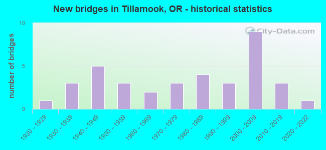
- New bridges - historical statistics
- 11920-1929
- 31930-1939
- 51940-1949
- 31950-1959
- 21960-1969
- 31970-1979
- 41980-1989
- 31990-1999
- 92000-2009
- 32010-2019
- 12020-2022


- Bridge Condition - Deck
- 2.7%Very good
- 54.1%Good
- 35.1%Satisfactory
- 8.1%Fair

- Bridge Condition - Superstructure
- 5.4%Very good
- 54.1%Good
- 24.3%Satisfactory
- 13.5%Fair
- 2.7%Poor

- Bridge Condition - Substructure
- 10.8%Very good
- 45.9%Good
- 32.4%Satisfactory
- 8.1%Fair
- 2.7%Poor

- Bridge Condition - Channel
- 22.2%Very good
- 33.3%Good
- 33.3%Satisfactory
- 11.1%Fair
Find on map >> Show street view
Structure Number: 505 009 06348, Location: 020 MI N TILLAMOOK (Lat: 45.489147, Lng: -123.845847), Route carried "on" structure: US 101, Year Built: 1931, Status: Open, Structure Length: 5.49m (18.01ft), Average Daily Traffic: 10,718 (year 2020), Truck Traffic: 7%, Average Future Daily Traffic: 13,000 (year 2040), Design Load: H 15, Features Intersected: POTB Railroad
Minimum Vertical Clearance: 30+ m (98+ ft), Kilometerpoint: 102.161, Lanes on structure: 2, Base Highway Network: Yes, Owner: State Highway Agency, Approaching Roadway Width: 8.2m (26.9ft), Skew: 5 degrees, Material/Design: Concrete continuous, Design/Construction: Tee Beam, Number Of Spans In Main Unit: 3, Length of Maximum Span: 18.3m (60.0ft), Curb or Sidewalk Widths: Left: 1.1m (3.6ft), Right: 1.1m (3.6ft), Curb-To-Curb Width: 8.2m (26.9ft), Out-to-Out Width: 11.1m (36.4ft)
Condition: Deck: Fair, Superstructure: Fair, Substructure: Fair, Operating Rating: 47.2 metric tons, Method Used To Determine Operating Rating: Load Factor (LF), Inventory Rating: 28.1 metric tons, Method Used To Determine Inventory Rating: Load Factor (LF), Structural Evaluation: Somewhat better than minimum adequacy, Deck Geometry: High priority of replacement, Underclear: Meets minimum limits, Approach Roadway Alignment: Equal to present desirable criteria, Length Of Structure Improvement: 5.50m (18.04ft), Designated Inspection Frequency: Every 24 months, Inspection Date: March 2020, Bridge Improvement Cost: $576,000, Roadway Improvement Cost: $58,000, Total Project Cost: $922,000, Deck Structure Type: Concrete Cast-file-Place, Wearing Surface/Protective System: Wearing Surface: Epoxy Overlay
Find on map >> Show street view
Structure Number: 1345C131 00749, Location: 012 W TILLAMOOK (Lat: 45.456878, Lng: -123.876903), Route carried "on" structure: Alternate State highway 131, Year Built: 1962, Year Reconstructed: 1987, Status: Open, Structure Length: 19.81m (64.99ft), Average Daily Traffic: 3,682 (year 2020), Truck Traffic: 10%, Average Future Daily Traffic: 4,200 (year 2040), Design Load: HS 20, Features Intersected: Tillamook River
Minimum Vertical Clearance: 30+ m (98+ ft), Kilometerpoint: 12.054, Lanes on structure: 2, Owner: State Highway Agency, Approaching Roadway Width: 7.9m (25.9ft), Skew: 9 degrees, Material/Design: Steel, Design/Construction: Stringer/Multi-beam, Number Of Spans In Main Unit: 1, Number Of Approach Spans: 19, Length of Maximum Span: 32.2m (105.6ft), Curb-To-Curb Width: 7.9m (25.9ft), Out-to-Out Width: 9.5m (31.2ft)
Condition: Deck: Satisfactory, Superstructure: Satisfactory, Substructure: Fair, Channel: Very good, Operating Rating: 22.7 metric tons, Method Used To Determine Operating Rating: Load and Resistance Factor Rating (LRFR) rating reported by rating factor(RF) method using HL-93 loadings, Inventory Rating: 17.5 metric tons, Method Used To Determine Inventory Rating: Load and Resistance Factor Rating (LRFR) rating reported by rating factor(RF) method using HL-93 loadings, Structural Evaluation: Meets minimum limits, Deck Geometry: High priority of corrective action, Waterway Adequacy: Equal to present desirable criteria, Approach Roadway Alignment: Equal to present desirable criteria, Length Of Structure Improvement: 19.80m (64.96ft), Designated Inspection Frequency: Every 24 months, Underwater Inspection Frequency: Every 36 months, Inspection Date: April 2020, Underwater Inspection Date: September 2020, Bridge Improvement Cost: $2,081,000, Roadway Improvement Cost: $208,000, Total Project Cost: $3,330,000, Deck Structure Type: Concrete Cast-file-Place, Wearing Surface/Protective System: Wearing Surface: Epoxy Overlay
Find on map >> Show street view
Structure Number: 1498 009 06414, Location: 014 MI N TILLAMOOK (Lat: 45.479547, Lng: -123.844667), Route carried "on" structure: US 101, Year Built: 1931, Status: Open, Structure Length: 3.66m (12.01ft), Average Daily Traffic: 11,016 (year 2020), Truck Traffic: 7%, Average Future Daily Traffic: 12,200 (year 2040), Design Load: H 15, Features Intersected: Wilson River Slough
Minimum Vertical Clearance: 30+ m (98+ ft), Kilometerpoint: 103.223, Lanes on structure: 2, Base Highway Network: Yes, Owner: State Highway Agency, Approaching Roadway Width: 8.2m (26.9ft), Material/Design: Concrete continuous, Design/Construction: Tee Beam, Number Of Spans In Main Unit: 3, Length of Maximum Span: 14.0m (45.9ft), Curb or Sidewalk Widths: Left: 1.1m (3.6ft), Right: 1.1m (3.6ft), Curb-To-Curb Width: 8.2m (26.9ft), Out-to-Out Width: 11.1m (36.4ft)
Condition: Deck: Satisfactory, Superstructure: Satisfactory, Substructure: Satisfactory, Channel: Good, Operating Rating: 55.3 metric tons, Method Used To Determine Operating Rating: Load Factor (LF), Inventory Rating: 33.6 metric tons, Method Used To Determine Inventory Rating: Load Factor (LF), Structural Evaluation: Equal to present minimum criteria, Deck Geometry: High priority of replacement, Waterway Adequacy: Equal to present desirable criteria, Approach Roadway Alignment: Equal to present desirable criteria, Length Of Structure Improvement: 3.70m (12.14ft), Designated Inspection Frequency: Every 24 months, Inspection Date: March 2020, Bridge Improvement Cost: $384,000, Roadway Improvement Cost: $38,000, Total Project Cost: $615,000, Deck Structure Type: Concrete Cast-file-Place, Wearing Surface/Protective System: Wearing Surface: Epoxy Overlay
Find on map >> Show street view
Structure Number: 1499 009 06423, Location: 013 MI N TILLAMOOK (Lat: 45.478325, Lng: -123.844514), Route carried "on" structure: US 101, Year Built: 1931, Status: Open, Structure Length: 6.07m (19.91ft), Average Daily Traffic: 11,016 (year 2020), Truck Traffic: 7%, Average Future Daily Traffic: 12,200 (year 2040), Design Load: H 15, Features Intersected: Wilson River
Minimum Vertical Clearance: 6.40m (21.00ft), Kilometerpoint: 103.368, Lanes on structure: 2, Base Highway Network: Yes, Owner: State Highway Agency, Approaching Roadway Width: 8.2m (26.9ft), Material/Design: Concrete, Design/Construction: Arch - Thru, Number Of Spans In Main Unit: 1, Number Of Approach Spans: 4, Length of Maximum Span: 36.6m (120.1ft), Curb or Sidewalk Widths: Left: 0.9m (3.0ft), Right: 0.9m (3.0ft), Curb-To-Curb Width: 8.2m (26.9ft), Out-to-Out Width: 13.2m (43.3ft)
Condition: Deck: Satisfactory, Superstructure: Fair, Substructure: Satisfactory, Channel: Satisfactory, Operating Rating: 22.7 metric tons, Method Used To Determine Operating Rating: Load and Resistance Factor Rating (LRFR) rating reported by rating factor(RF) method using HL-93 loadings, Inventory Rating: 17.5 metric tons, Method Used To Determine Inventory Rating: Load and Resistance Factor Rating (LRFR) rating reported by rating factor(RF) method using HL-93 loadings, Structural Evaluation: Meets minimum limits, Deck Geometry: High priority of corrective action, Waterway Adequacy: Equal to present desirable criteria, Approach Roadway Alignment: Equal to present desirable criteria, Length Of Structure Improvement: 6.10m (20.01ft), Designated Inspection Frequency: Every 24 months, Underwater Inspection Frequency: Every 60 months, Inspection Date: March 2020, Underwater Inspection Date: May 2018, Bridge Improvement Cost: $638,000, Roadway Improvement Cost: $64,000, Total Project Cost: $1,021,000, Deck Structure Type: Concrete Cast-file-Place, Wearing Surface/Protective System: Wearing Surface: Epoxy Overlay
Find on map >> Show street view
Structure Number: 1594A741 00215, Location: 1.6 MI S TILLAMOOK/HWY101 (Lat: 45.430400, Lng: -123.844808), Route carried "on" structure: County highway A0711, Year Built: 1976, Status: Open, Structure Length: 7.01m (23.00ft), Average Daily Traffic: 1,411 (year 2020), Truck Traffic: 15%, Average Future Daily Traffic: 1,676 (year 2025), Design Load: HS 20, Features Intersected: TILLAMOOK RIVER, Facility Carried by Structure: TILLAMOOK RIVER RD
Minimum Vertical Clearance: 30+ m (98+ ft), Kilometerpoint: 3.621, Lanes on structure: 2, Owner: County Highway Agency, Approaching Roadway Width: 9.8m (32.2ft), Material/Design: Prestressed concrete, Design/Construction: Box Beam or Girders - Multiple, Number Of Spans In Main Unit: 1, Number Of Approach Spans: 5, Length of Maximum Span: 23.2m (76.1ft), Curb-To-Curb Width: 9.1m (29.9ft), Out-to-Out Width: 10.0m (32.8ft)
Condition: Deck: Good, Superstructure: Good, Substructure: Satisfactory, Channel: Good, Operating Rating: 42.1 metric tons, Method Used To Determine Operating Rating: Load and Resistance Factor Rating (LRFR) rating reported by rating factor(RF) method using HL-93 loadings, Inventory Rating: 32.4 metric tons, Method Used To Determine Inventory Rating: Load and Resistance Factor Rating (LRFR) rating reported by rating factor(RF) method using HL-93 loadings, Structural Evaluation: Equal to present minimum criteria, Deck Geometry: Somewhat better than minimum adequacy, Waterway Adequacy: Equal to present desirable criteria, Approach Roadway Alignment: Equal to present desirable criteria, Designated Inspection Frequency: Every 24 months, Underwater Inspection Frequency: Every 60 months, Inspection Date: June 2021, Underwater Inspection Date: September 2020, Deck Structure Type: Other, Wearing Surface/Protective System: Wearing Surface: Bituminous
Find on map >> Show street view
Structure Number: 4642A009 06845, Location: 023 MI S TILLAMOOK (Lat: 45.422578, Lng: -123.824336), Route carried "on" structure: US 101, Year Built: 1949, Status: Open, Structure Length: 2.41m (7.91ft), Average Daily Traffic: 7,468 (year 2020), Truck Traffic: 20%, Average Future Daily Traffic: 8,200 (year 2040), Design Load: HS 20, Features Intersected: South Prairie Creek
Minimum Vertical Clearance: 30+ m (98+ ft), Kilometerpoint: 110.160, Lanes on structure: 2, Base Highway Network: Yes, Owner: State Highway Agency, Approaching Roadway Width: 11.6m (38.1ft), Material/Design: Concrete continuous, Design/Construction: Slab, Number Of Spans In Main Unit: 4, Length of Maximum Span: 6.6m (21.7ft), Curb-To-Curb Width: 11.6m (38.1ft), Out-to-Out Width: 13.2m (43.3ft)
Condition: Deck: Good, Superstructure: Good, Substructure: Satisfactory, Channel: Fair, Operating Rating: 33.6 metric tons, Method Used To Determine Operating Rating: Load Factor (LF), Inventory Rating: 20.0 metric tons, Method Used To Determine Inventory Rating: Load Factor (LF), Structural Evaluation: Somewhat better than minimum adequacy, Deck Geometry: Somewhat better than minimum adequacy, Waterway Adequacy: Equal to present desirable criteria, Approach Roadway Alignment: Equal to present desirable criteria, Designated Inspection Frequency: Every 24 months, Inspection Date: March 2020, Deck Structure Type: Concrete Cast-file-Place, Wearing Surface/Protective System: Wearing Surface: Bituminous
Find on map >> Show street view
Structure Number: 4643A009 06867, Location: 025 MI S TILLAMOOK (Lat: 45.419522, Lng: -123.824397), Route carried "on" structure: US 101, Year Built: 1949, Status: Open, Structure Length: 1.71m (5.61ft), Average Daily Traffic: 7,468 (year 2020), Truck Traffic: 20%, Average Future Daily Traffic: 8,200 (year 2040), Design Load: HS 20, Features Intersected: Anderson Creek
Minimum Vertical Clearance: 30+ m (98+ ft), Kilometerpoint: 110.514, Lanes on structure: 2, Base Highway Network: Yes, Owner: State Highway Agency, Approaching Roadway Width: 11.6m (38.1ft), Material/Design: Concrete continuous, Design/Construction: Slab, Number Of Spans In Main Unit: 3, Length of Maximum Span: 6.4m (21.0ft), Curb-To-Curb Width: 11.6m (38.1ft), Out-to-Out Width: 13.2m (43.3ft)
Condition: Deck: Satisfactory, Superstructure: Good, Substructure: Good, Channel: Satisfactory, Operating Rating: 36.3 metric tons, Method Used To Determine Operating Rating: Load Factor (LF), Inventory Rating: 21.8 metric tons, Method Used To Determine Inventory Rating: Load Factor (LF), Structural Evaluation: Somewhat better than minimum adequacy, Deck Geometry: Somewhat better than minimum adequacy, Waterway Adequacy: Equal to present desirable criteria, Approach Roadway Alignment: Equal to present desirable criteria, Designated Inspection Frequency: Every 24 months, Inspection Date: March 2020, Deck Structure Type: Concrete Cast-file-Place, Wearing Surface/Protective System: Wearing Surface: Bituminous
Find on map >> Show street view
Structure Number: 5640A131 00833, Location: 00.2 MILE W TILLAMOOK (Lat: 45.456211, Lng: -123.859794), Route carried "on" structure: Alternate State highway 131, Year Built: 1948, Status: Open, Structure Length: 10.16m (33.33ft), Average Daily Traffic: 4,273 (year 2020), Truck Traffic: 10%, Average Future Daily Traffic: 4,800 (year 2040), Design Load: H 15, Features Intersected: Trask River
Minimum Vertical Clearance: 30+ m (98+ ft), Kilometerpoint: 13.406, Lanes on structure: 2, Owner: State Highway Agency, Approaching Roadway Width: 8.5m (27.9ft), Material/Design: Steel, Design/Construction: Truss - Thru, Number Of Spans In Main Unit: 1, Number Of Approach Spans: 12, Length of Maximum Span: 30.6m (100.4ft), Curb or Sidewalk Widths: Left: 1.1m (3.6ft), Right: 1.1m (3.6ft), Curb-To-Curb Width: 7.9m (25.9ft), Out-to-Out Width: 10.8m (35.4ft)
Condition: Deck: Satisfactory, Superstructure: Fair, Substructure: Fair, Channel: Satisfactory, Operating Rating: 30.8 metric tons, Method Used To Determine Operating Rating: Load Factor (LF), Inventory Rating: 18.1 metric tons, Method Used To Determine Inventory Rating: Load Factor (LF), Structural Evaluation: Somewhat better than minimum adequacy, Deck Geometry: High priority of corrective action, Waterway Adequacy: Equal to present desirable criteria, Approach Roadway Alignment: Equal to present desirable criteria, Length Of Structure Improvement: 10.20m (33.46ft), Designated Inspection Frequency: Every 24 months, Critical Feature Inspection Frequency: Every 24 months, Underwater Inspection Frequency: Every 36 months, Inspection Date: April 2020, Critical Feature Inspection Date: April 2020, Underwater Inspection Date: March 2021, Bridge Improvement Cost: $1,067,000, Roadway Improvement Cost: $107,000, Total Project Cost: $1,708,000, Deck Structure Type: Concrete Cast-file-Place, Wearing Surface/Protective System: Wearing Surface: Epoxy Overlay
Find on map >> Show street view
Structure Number: 6550 734 00142, Location: 010 MI NE TILLAMOOK AIRPT (Lat: 45.426819, Lng: -123.795681), Route carried "on" structure: County highway A723, Year Built: 1942, Status: Open, Structure Length: 1.58m (5.18ft), Average Daily Traffic: 3,395 (year 2020), Truck Traffic: 15%, Average Future Daily Traffic: 4,030 (year 2025), Design Load: HS 15, Features Intersected: MILL CREEK, Facility Carried by Structure: LONG PRAIRIE RD
Minimum Vertical Clearance: 30+ m (98+ ft), Kilometerpoint: 2.237, Lanes on structure: 2, Owner: County Highway Agency, Approaching Roadway Width: 7.9m (25.9ft), Material/Design: Concrete continuous, Design/Construction: Tee Beam, Number Of Spans In Main Unit: 3, Length of Maximum Span: 10.4m (34.1ft), Curb-To-Curb Width: 7.9m (25.9ft), Out-to-Out Width: 9.0m (29.5ft)
Condition: Deck: Good, Superstructure: Good, Substructure: Good, Channel: Satisfactory, Operating Rating: 30.8 metric tons, Method Used To Determine Operating Rating: Load and Resistance Factor Rating (LRFR) rating reported by rating factor(RF) method using HL-93 loadings, Inventory Rating: 23.7 metric tons, Method Used To Determine Inventory Rating: Load and Resistance Factor Rating (LRFR) rating reported by rating factor(RF) method using HL-93 loadings, Structural Evaluation: Equal to present minimum criteria, Deck Geometry: High priority of corrective action, Waterway Adequacy: Equal to present minimum criteria, Approach Roadway Alignment: Equal to present desirable criteria, Length Of Structure Improvement: 1.60m (5.25ft), Designated Inspection Frequency: Every 24 months, Inspection Date: June 2021, Bridge Improvement Cost: $167,000, Roadway Improvement Cost: $17,000, Total Project Cost: $266,000, Deck Structure Type: Concrete Cast-file-Place, Wearing Surface/Protective System: Wearing Surface: Bituminous
Find on map >> Show street view
Structure Number: 7147 009 06798, Location: 018 MI S TILLAMOOK (Lat: 45.429522, Lng: -123.824167), Route carried "on" structure: US 101, Year Built: 1949, Status: Open, Structure Length: 10.24m (33.60ft), Average Daily Traffic: 7,603 (year 2020), Truck Traffic: 17%, Average Future Daily Traffic: 8,400 (year 2040), Design Load: HS 20, Features Intersected: Trask River
Minimum Vertical Clearance: 30+ m (98+ ft), Kilometerpoint: 109.403, Lanes on structure: 2, Base Highway Network: Yes, Owner: State Highway Agency, Approaching Roadway Width: 9.1m (29.9ft), Material/Design: Concrete continuous, Design/Construction: Tee Beam, Number Of Spans In Main Unit: 3, Number Of Approach Spans: 8, Length of Maximum Span: 21.3m (69.9ft), Curb or Sidewalk Widths: Left: 1.1m (3.6ft), Right: 1.1m (3.6ft), Curb-To-Curb Width: 9.1m (29.9ft), Out-to-Out Width: 11.9m (39.0ft)
Condition: Deck: Satisfactory, Superstructure: Satisfactory, Substructure: Satisfactory, Channel: Fair, Operating Rating: 26.6 metric tons, Method Used To Determine Operating Rating: Load and Resistance Factor Rating (LRFR) rating reported by rating factor(RF) method using HL-93 loadings, Inventory Rating: 20.4 metric tons, Method Used To Determine Inventory Rating: Load and Resistance Factor Rating (LRFR) rating reported by rating factor(RF) method using HL-93 loadings, Structural Evaluation: Somewhat better than minimum adequacy, Deck Geometry: Meets minimum limits, Waterway Adequacy: Equal to present desirable criteria, Approach Roadway Alignment: Equal to present desirable criteria, Designated Inspection Frequency: Every 24 months, Underwater Inspection Frequency: Every 24 months, Inspection Date: March 2020, Underwater Inspection Date: November 2021, Deck Structure Type: Concrete Cast-file-Place, Wearing Surface/Protective System: Wearing Surface: Epoxy Overlay
Find on map >> Show street view
Structure Number: 7181 009 07118, Location: 050 MI S TILLAMOOK (Lat: 45.389825, Lng: -123.803083), Route carried "on" structure: US 101, Year Built: 1950, Status: Open, Structure Length: 3.06m (10.04ft), Average Daily Traffic: 5,649 (year 2020), Truck Traffic: 20%, Average Future Daily Traffic: 6,200 (year 2040), Design Load: HS 20, Features Intersected: Fawcett Creek
Minimum Vertical Clearance: 30+ m (98+ ft), Kilometerpoint: 114.553, Lanes on structure: 2, Base Highway Network: Yes, Owner: State Highway Agency, Approaching Roadway Width: 11.6m (38.1ft), Material/Design: Concrete continuous, Design/Construction: Slab, Number Of Spans In Main Unit: 5, Length of Maximum Span: 6.6m (21.7ft), Curb-To-Curb Width: 11.6m (38.1ft), Out-to-Out Width: 13.2m (43.3ft)
Condition: Deck: Satisfactory, Superstructure: Good, Substructure: Satisfactory, Channel: Satisfactory, Operating Rating: 27.9 metric tons, Method Used To Determine Operating Rating: Load and Resistance Factor Rating (LRFR) rating reported by rating factor(RF) method using HL-93 loadings, Inventory Rating: 21.4 metric tons, Method Used To Determine Inventory Rating: Load and Resistance Factor Rating (LRFR) rating reported by rating factor(RF) method using HL-93 loadings, Structural Evaluation: Somewhat better than minimum adequacy, Deck Geometry: Somewhat better than minimum adequacy, Waterway Adequacy: Equal to present desirable criteria, Approach Roadway Alignment: Equal to present desirable criteria, Designated Inspection Frequency: Every 24 months, Inspection Date: March 2020, Deck Structure Type: Concrete Cast-file-Place, Wearing Surface/Protective System: Wearing Surface: Bituminous
Find on map >> Show street view
Structure Number: 7224 009 06636, Location: 001 MI S TILLAMOOK (Lat: 45.447800, Lng: -123.842633), Route carried "on" structure: US 101, Year Built: 1950, Status: Open, Structure Length: 1.58m (5.18ft), Average Daily Traffic: 7,986 (year 2020), Truck Traffic: 17%, Average Future Daily Traffic: 8,800 (year 2040), Design Load: HS 20, Features Intersected: Drainage Ditch
Minimum Vertical Clearance: 30+ m (98+ ft), Kilometerpoint: 106.796, Lanes on structure: 3, Base Highway Network: Yes, Owner: State Highway Agency, Approaching Roadway Width: 19.5m (64.0ft), Skew: 20 degrees, Material/Design: Concrete continuous, Design/Construction: Slab, Number Of Spans In Main Unit: 3, Length of Maximum Span: 6.1m (20.0ft), Curb-To-Curb Width: 19.5m (64.0ft), Out-to-Out Width: 22.3m (73.2ft)
Condition: Deck: Satisfactory, Superstructure: Satisfactory, Substructure: Satisfactory, Channel: Very good, Operating Rating: 35.4 metric tons, Method Used To Determine Operating Rating: Load Factor (LF), Inventory Rating: 20.9 metric tons, Method Used To Determine Inventory Rating: Load Factor (LF), Structural Evaluation: Somewhat better than minimum adequacy, Deck Geometry: Superior to present desirable criteria, Waterway Adequacy: Equal to present desirable criteria, Approach Roadway Alignment: Equal to present desirable criteria, Designated Inspection Frequency: Every 24 months, Inspection Date: March 2020, Deck Structure Type: Concrete Cast-file-Place, Wearing Surface/Protective System: Wearing Surface: Epoxy Overlay
Find on map >> Show street view
Structure Number: 11340A694 00075, Location: 02.0 MI NE TILLAMOOK (Lat: 45.470464, Lng: -123.809806), Route carried "on" structure: County highway A0724, Year Built: 1952, Status: Open, Structure Length: 4.79m (15.72ft), Average Daily Traffic: 3,183 (year 2020), Truck Traffic: 15%, Average Future Daily Traffic: 3,768 (year 2025), Design Load: HS 20, Features Intersected: DOUGHERTY SLOUGH, Facility Carried by Structure: WILSON RIVER LOOP
Minimum Vertical Clearance: 30+ m (98+ ft), Kilometerpoint: 0.801, Lanes on structure: 2, Owner: County Highway Agency, Approaching Roadway Width: 7.9m (25.9ft), Material/Design: Concrete continuous, Design/Construction: Stringer/Multi-beam, Number Of Spans In Main Unit: 3, Length of Maximum Span: 17.7m (58.1ft), Curb or Sidewalk Widths: Left: 0.5m (1.6ft), Right: 0.5m (1.6ft), Curb-To-Curb Width: 8.0m (26.2ft), Out-to-Out Width: 9.4m (30.8ft)
Condition: Deck: Satisfactory, Superstructure: Satisfactory, Substructure: Good, Channel: Satisfactory, Operating Rating: 56.2 metric tons, Method Used To Determine Operating Rating: Load Factor (LF), Inventory Rating: 33.6 metric tons, Method Used To Determine Inventory Rating: Load Factor (LF), Structural Evaluation: Equal to present minimum criteria, Deck Geometry: High priority of corrective action, Waterway Adequacy: Equal to present desirable criteria, Approach Roadway Alignment: Equal to present minimum criteria, Length Of Structure Improvement: 4.80m (15.75ft), Designated Inspection Frequency: Every 24 months, Underwater Inspection Frequency: Every 60 months, Inspection Date: August 2020, Underwater Inspection Date: March 2021, Bridge Improvement Cost: $503,000, Roadway Improvement Cost: $50,000, Total Project Cost: $804,000, Deck Structure Type: Concrete Cast-file-Place, Wearing Surface/Protective System: Wearing Surface: Monolithic Concrete
Find on map >> Show street view
Structure Number: 17370 009 06499, Location: 005 MI N TILLAMOOK (Lat: 45.467211, Lng: -123.844342), Route carried "on" structure: US 101, Year Built: 2000, Status: Open, Structure Length: 2.01m (6.59ft), Average Daily Traffic: 15,961 (year 2020), Truck Traffic: 7%, Average Future Daily Traffic: 18,300 (year 2040), Design Load: HS 25 or greater, Features Intersected: Hall Slough
Minimum Vertical Clearance: 30+ m (98+ ft), Kilometerpoint: 104.591, Lanes on structure: 4, Base Highway Network: Yes, Owner: State Highway Agency, Approaching Roadway Width: 23.8m (78.1ft), Skew: 1 degrees, Material/Design: Prestressed concrete, Design/Construction: Slab, Number Of Spans In Main Unit: 1, Length of Maximum Span: 20.1m (65.9ft), Curb or Sidewalk Widths: Left: 2.0m (6.6ft), Right: 2.0m (6.6ft), Curb-To-Curb Width: 23.8m (78.1ft), Out-to-Out Width: 28.3m (92.8ft)
Condition: Deck: Good, Superstructure: Good, Substructure: Good, Channel: Very good, Operating Rating: 42.4 metric tons, Method Used To Determine Operating Rating: Load and Resistance Factor Rating (LRFR) rating reported by rating factor(RF) method using HL-93 loadings, Inventory Rating: 32.7 metric tons, Method Used To Determine Inventory Rating: Load and Resistance Factor Rating (LRFR) rating reported by rating factor(RF) method using HL-93 loadings, Structural Evaluation: Better than present minimum criteria, Deck Geometry: Superior to present desirable criteria, Waterway Adequacy: Equal to present minimum criteria, Approach Roadway Alignment: Equal to present desirable criteria, Designated Inspection Frequency: Every 24 months, Inspection Date: March 2020, Deck Structure Type: Concrete Precast Panels, Wearing Surface/Protective System: Wearing Surface: Bituminous, Membrane: Preformed Fabric, Deck Protection: Epoxy Coated Reinforcing
Find on map >> Show street view
Structure Number: 17371 009 06512, Location: 004 MI N TILLAMOOK (Lat: 45.465333, Lng: -123.844397), Route carried "on" structure: US 101, Year Built: 2000, Status: Open, Structure Length: 4.05m (13.29ft), Average Daily Traffic: 15,872 (year 2020), Truck Traffic: 7%, Average Future Daily Traffic: 17,600 (year 2040), Design Load: HS 25 or greater, Features Intersected: Dougherty Slough
Minimum Vertical Clearance: 30+ m (98+ ft), Kilometerpoint: 104.800, Lanes on structure: 4, Base Highway Network: Yes, Owner: State Highway Agency, Approaching Roadway Width: 23.8m (78.1ft), Material/Design: Prestressed concrete, Design/Construction: Slab, Number Of Spans In Main Unit: 2, Length of Maximum Span: 20.3m (66.6ft), Curb or Sidewalk Widths: Left: 2.0m (6.6ft), Right: 2.0m (6.6ft), Curb-To-Curb Width: 23.8m (78.1ft), Out-to-Out Width: 28.3m (92.8ft)
Condition: Deck: Good, Superstructure: Good, Substructure: Good, Channel: Good, Operating Rating: 42.4 metric tons, Method Used To Determine Operating Rating: Load and Resistance Factor Rating (LRFR) rating reported by rating factor(RF) method using HL-93 loadings, Inventory Rating: 32.7 metric tons, Method Used To Determine Inventory Rating: Load and Resistance Factor Rating (LRFR) rating reported by rating factor(RF) method using HL-93 loadings, Structural Evaluation: Better than present minimum criteria, Deck Geometry: Superior to present desirable criteria, Waterway Adequacy: Equal to present minimum criteria, Approach Roadway Alignment: Equal to present desirable criteria, Designated Inspection Frequency: Every 24 months, Underwater Inspection Frequency: Every 60 months, Inspection Date: March 2020, Underwater Inspection Date: May 2019, Deck Structure Type: Concrete Precast Panels, Wearing Surface/Protective System: Wearing Surface: Bituminous, Membrane: Preformed Fabric
Find on map >> Show street view
Structure Number: 17929 741 0033, Location: 002 S OF TILLAMOOK (Lat: 45.446169, Lng: -123.844650), Route carried "on" structure: County highway A0711, Year Built: 1997, Status: Open, Structure Length: 6.19m (20.31ft), Average Daily Traffic: 3,183 (year 2020), Truck Traffic: 15%, Average Future Daily Traffic: 3,493 (year 2025), Design Load: HS 20, Features Intersected: TRASK RIVER, Facility Carried by Structure: TILLAMOOK RIVER RD
Minimum Vertical Clearance: 30+ m (98+ ft), Kilometerpoint: 5.391, Lanes on structure: 2, Owner: County Highway Agency, Approaching Roadway Width: 11.0m (36.1ft), Material/Design: Prestressed concrete continuous, Design/Construction: Box Beam or Girders - Multiple, Number Of Spans In Main Unit: 1, Number Of Approach Spans: 2, Length of Maximum Span: 29.9m (98.1ft), Curb or Sidewalk Widths: Left: 1.8m (5.9ft), Right: 0.0m, Curb-To-Curb Width: 11.0m (36.1ft), Out-to-Out Width: 13.4m (44.0ft)
Condition: Deck: Good, Superstructure: Good, Substructure: Good, Channel: Good, Operating Rating: 36.9 metric tons, Method Used To Determine Operating Rating: Load and Resistance Factor Rating (LRFR) rating reported by rating factor(RF) method using HL-93 loadings, Inventory Rating: 28.5 metric tons, Method Used To Determine Inventory Rating: Load and Resistance Factor Rating (LRFR) rating reported by rating factor(RF) method using HL-93 loadings, Structural Evaluation: Better than present minimum criteria, Deck Geometry: Somewhat better than minimum adequacy, Waterway Adequacy: Equal to present desirable criteria, Approach Roadway Alignment: Equal to present desirable criteria, Designated Inspection Frequency: Every 24 months, Underwater Inspection Frequency: Every 60 months, Inspection Date: June 2021, Underwater Inspection Date: September 2020, Deck Structure Type: Concrete Precast Panels, Wearing Surface/Protective System: Wearing Surface: Monolithic Concrete
Find on map >> Show street view
Structure Number: 18232 741 0034, Location: 002 MI SOUTH TILLAMOOK (Lat: 45.447919, Lng: -123.844650), Route carried "on" structure: County highway A0711, Year Built: 1997, Status: Open, Structure Length: 2.19m (7.19ft), Average Daily Traffic: 2,652 (year 2020), Truck Traffic: 15%, Average Future Daily Traffic: 3,157 (year 2025), Design Load: HS 25 or greater, Features Intersected: TRASK RIVER OVERFLOW, Facility Carried by Structure: TILLAMOOK RIVER RD
Minimum Vertical Clearance: 30+ m (98+ ft), Kilometerpoint: 5.568, Lanes on structure: 2, Owner: County Highway Agency, Approaching Roadway Width: 11.0m (36.1ft), Material/Design: Prestressed concrete, Design/Construction: Slab, Number Of Spans In Main Unit: 1, Length of Maximum Span: 20.4m (66.9ft), Curb-To-Curb Width: 11.4m (37.4ft), Out-to-Out Width: 11.6m (38.1ft)
Condition: Deck: Good, Superstructure: Good, Substructure: Good, Channel: Very good, Operating Rating: 84.4 metric tons, Method Used To Determine Operating Rating: Load Factor (LF), Inventory Rating: 50.8 metric tons, Method Used To Determine Inventory Rating: Load Factor (LF), Structural Evaluation: Better than present minimum criteria, Deck Geometry: Somewhat better than minimum adequacy, Waterway Adequacy: Equal to present desirable criteria, Approach Roadway Alignment: Equal to present desirable criteria, Designated Inspection Frequency: Every 24 months, Inspection Date: June 2021, Deck Structure Type: Concrete Precast Panels, Wearing Surface/Protective System: Wearing Surface: Bituminous, Membrane: Preformed Fabric
Find on map >> Show street view
Structure Number: 18538 753 00002, Location: 030 MI SOUTH OF TILLAMOOK (Lat: 45.407961, Lng: -123.824519), Route carried "on" structure: County highway C0753, Year Built: 1999, Status: Open, Structure Length: 3.26m (10.70ft), Average Daily Traffic: 1,273 (year 2020), Truck Traffic: 15%, Average Future Daily Traffic: 1,518 (year 2025), Design Load: HS 20, Features Intersected: TILLAMOOK RIVER, Facility Carried by Structure: BEWLEY CR ROAD
Minimum Vertical Clearance: 30+ m (98+ ft), Kilometerpoint: 0.080, Lanes on structure: 2, Owner: County Highway Agency, Approaching Roadway Width: 9.8m (32.2ft), Material/Design: Prestressed concrete, Design/Construction: Slab, Number Of Spans In Main Unit: 3, Length of Maximum Span: 17.1m (56.1ft), Curb-To-Curb Width: 9.2m (30.2ft), Out-to-Out Width: 9.8m (32.2ft)
Condition: Deck: Good, Superstructure: Good, Substructure: Good, Channel: Satisfactory, Operating Rating: 89.8 metric tons, Method Used To Determine Operating Rating: Load Factor (LF), Inventory Rating: 57.2 metric tons, Method Used To Determine Inventory Rating: Load Factor (LF), Structural Evaluation: Better than present minimum criteria, Deck Geometry: Somewhat better than minimum adequacy, Waterway Adequacy: Equal to present desirable criteria, Approach Roadway Alignment: Equal to present desirable criteria, Designated Inspection Frequency: Every 24 months, Inspection Date: June 2021, Deck Structure Type: Concrete Precast Panels, Wearing Surface/Protective System: Wearing Surface: Bituminous, Membrane: Preformed Fabric
Find on map >> Show street view
Structure Number: 18592 694 00082, Location: .12 M N OF HWY 37 (Lat: 45.465531, Lng: -123.809519), Route carried "on" structure: County highway A0724, Year Built: 2000, Status: Open, Structure Length: 14.11m (46.29ft), Average Daily Traffic: 2,962 (year 2020), Truck Traffic: 15%, Average Future Daily Traffic: 3,412 (year 2025), Design Load: HL 93, Features Intersected: O'FLOW BRIDGE, Facility Carried by Structure: WILSON RIVER LOOP
Minimum Vertical Clearance: 30+ m (98+ ft), Kilometerpoint: 1.320, Lanes on structure: 2, Owner: County Highway Agency, Approaching Roadway Width: 9.1m (29.9ft), Material/Design: Concrete continuous, Design/Construction: Slab, Number Of Spans In Main Unit: 9, Length of Maximum Span: 15.7m (51.5ft), Curb-To-Curb Width: 9.6m (31.5ft), Out-to-Out Width: 9.6m (31.5ft)
Condition: Deck: Satisfactory, Superstructure: Satisfactory, Substructure: Good, Channel: Very good, Operating Rating: 36.9 metric tons, Method Used To Determine Operating Rating: Load and Resistance Factor Rating (LRFR) rating reported by rating factor(RF) method using HL-93 loadings, Inventory Rating: 28.5 metric tons, Method Used To Determine Inventory Rating: Load and Resistance Factor Rating (LRFR) rating reported by rating factor(RF) method using HL-93 loadings, Structural Evaluation: Equal to present minimum criteria, Deck Geometry: Meets minimum limits, Waterway Adequacy: Equal to present desirable criteria, Approach Roadway Alignment: Equal to present desirable criteria, Designated Inspection Frequency: Every 24 months, Inspection Date: August 2020, Wearing Surface/Protective System: Wearing Surface: Monolithic Concrete, Deck Protection: Epoxy Coated Reinforcing
Find on map >> Show street view
Structure Number: 18593 694 00069, Location: .36 M N OF HWY 37 (Lat: 45.467261, Lng: -123.809919), Route carried "on" structure: County highway A0724, Year Built: 2000, Status: Open, Structure Length: 15.70m (51.51ft), Average Daily Traffic: 2,876 (year 2020), Truck Traffic: 15%, Average Future Daily Traffic: 3,291 (year 2025), Design Load: HL 93, Features Intersected: O'FLOW BR, Facility Carried by Structure: WILSON RIVER LOOP
Minimum Vertical Clearance: 30+ m (98+ ft), Kilometerpoint: 1.110, Lanes on structure: 2, Owner: County Highway Agency, Approaching Roadway Width: 9.1m (29.9ft), Material/Design: Concrete continuous, Design/Construction: Slab, Number Of Spans In Main Unit: 10, Length of Maximum Span: 15.7m (51.5ft), Curb-To-Curb Width: 9.6m (31.5ft), Out-to-Out Width: 9.6m (31.5ft)
Condition: Deck: Satisfactory, Superstructure: Satisfactory, Substructure: Satisfactory, Channel: Very good, Operating Rating: 36.9 metric tons, Method Used To Determine Operating Rating: Load and Resistance Factor Rating (LRFR) rating reported by rating factor(RF) method using HL-93 loadings, Inventory Rating: 28.5 metric tons, Method Used To Determine Inventory Rating: Load and Resistance Factor Rating (LRFR) rating reported by rating factor(RF) method using HL-93 loadings, Structural Evaluation: Equal to present minimum criteria, Deck Geometry: Meets minimum limits, Waterway Adequacy: Equal to present minimum criteria, Approach Roadway Alignment: Equal to present desirable criteria, Designated Inspection Frequency: Every 24 months, Inspection Date: August 2020, Wearing Surface/Protective System: Wearing Surface: Monolithic Concrete, Deck Protection: Epoxy Coated Reinforcing
Find on map >> Show street view
Structure Number: 18594 694 00059, Location: .63 M N OF HWY 37 (Lat: 45.469161, Lng: -123.809831), Route carried "on" structure: County highway A0724, Year Built: 2000, Status: Open, Structure Length: 4.71m (15.45ft), Average Daily Traffic: 2,876 (year 2020), Truck Traffic: 15%, Average Future Daily Traffic: 3,291 (year 2025), Design Load: HL 93, Features Intersected: CREEK, Facility Carried by Structure: WILSON RIVER LOOP
Minimum Vertical Clearance: 30+ m (98+ ft), Kilometerpoint: 0.950, Lanes on structure: 2, Owner: County Highway Agency, Approaching Roadway Width: 9.1m (29.9ft), Material/Design: Concrete continuous, Design/Construction: Slab, Number Of Spans In Main Unit: 3, Length of Maximum Span: 15.7m (51.5ft), Curb-To-Curb Width: 9.6m (31.5ft), Out-to-Out Width: 9.6m (31.5ft)
Condition: Deck: Good, Superstructure: Good, Substructure: Good, Channel: Very good, Operating Rating: 37.3 metric tons, Method Used To Determine Operating Rating: Load and Resistance Factor Rating (LRFR) rating reported by rating factor(RF) method using HL-93 loadings, Inventory Rating: 28.8 metric tons, Method Used To Determine Inventory Rating: Load and Resistance Factor Rating (LRFR) rating reported by rating factor(RF) method using HL-93 loadings, Structural Evaluation: Better than present minimum criteria, Deck Geometry: Meets minimum limits, Waterway Adequacy: Equal to present desirable criteria, Approach Roadway Alignment: Equal to present desirable criteria, Designated Inspection Frequency: Every 24 months, Inspection Date: August 2020, Wearing Surface/Protective System: Wearing Surface: Monolithic Concrete, Deck Protection: Epoxy Coated Reinforcing
Find on map >> Show street view
Structure Number: 19625 741 00105, Location: 010 MI W TILLAMOOK AIRPRT (Lat: 45.415511, Lng: -123.842181), Route carried "on" structure: County highway A0711, Year Built: 2003, Status: Open, Structure Length: 2.84m (9.32ft), Average Daily Traffic: 863 (year 2020), Truck Traffic: 15%, Average Future Daily Traffic: 1,003 (year 2025), Design Load: HS 25 or greater, Features Intersected: TILLAMOOK RV, Facility Carried by Structure: TILLAMOOK RIVER RD
Minimum Vertical Clearance: 30+ m (98+ ft), Kilometerpoint: 1.716, Lanes on structure: 2, Owner: County Highway Agency, Approaching Roadway Width: 11.0m (36.1ft), Skew: 3 degrees, Material/Design: Prestressed concrete, Design/Construction: Stringer/Multi-beam, Number Of Spans In Main Unit: 1, Length of Maximum Span: 28.0m (91.9ft), Curb-To-Curb Width: 10.4m (34.1ft), Out-to-Out Width: 11.2m (36.7ft)
Condition: Deck: Good, Superstructure: Good, Substructure: Good, Channel: Satisfactory, Operating Rating: 89.8 metric tons, Method Used To Determine Operating Rating: Load Factor (LF), Inventory Rating: 60.8 metric tons, Method Used To Determine Inventory Rating: Load Factor (LF), Structural Evaluation: Better than present minimum criteria, Deck Geometry: Equal to present minimum criteria, Waterway Adequacy: Equal to present desirable criteria, Approach Roadway Alignment: Equal to present desirable criteria, Designated Inspection Frequency: Every 24 months, Inspection Date: June 2021, Deck Structure Type: Concrete Cast-file-Place, Wearing Surface/Protective System: Wearing Surface: Monolithic Concrete, Deck Protection: Epoxy Coated Reinforcing
Find on map >> Show street view
Structure Number: 20306 734 00325, Location: 03.5 MI SE TILLAMOOK (Lat: 45.440658, Lng: -123.777258), Route carried "on" structure: County highway A0723, Year Built: 2008, Status: Open, Structure Length: 7.92m (25.98ft), Average Daily Traffic: 2,440 (year 2020), Truck Traffic: 15%, Average Future Daily Traffic: 2,890 (year 2025), Design Load: HL 93, Features Intersected: TRASK RIVER, Facility Carried by Structure: LONG PRAIRIE RD
Minimum Vertical Clearance: 30+ m (98+ ft), Kilometerpoint: 5.118, Lanes on structure: 2, Owner: County Highway Agency, Approaching Roadway Width: 7.6m (24.9ft), Material/Design: Prestressed concrete continuous, Design/Construction: Stringer/Multi-beam, Number Of Spans In Main Unit: 2, Length of Maximum Span: 39.6m (129.9ft), Curb-To-Curb Width: 7.9m (25.9ft), Out-to-Out Width: 11.8m (38.7ft)
Condition: Deck: Good, Superstructure: Very good, Substructure: Good, Channel: Satisfactory, Operating Rating: 45.7 metric tons, Method Used To Determine Operating Rating: Load and Resistance Factor Rating (LRFR) rating reported by rating factor(RF) method using HL-93 loadings, Inventory Rating: 35.3 metric tons, Method Used To Determine Inventory Rating: Load and Resistance Factor Rating (LRFR) rating reported by rating factor(RF) method using HL-93 loadings, Structural Evaluation: Better than present minimum criteria, Deck Geometry: High priority of corrective action, Waterway Adequacy: Equal to present desirable criteria, Approach Roadway Alignment: Equal to present desirable criteria, Designated Inspection Frequency: Every 24 months, Underwater Inspection Frequency: Every 60 months, Inspection Date: June 2021, Underwater Inspection Date: May 2019, Deck Structure Type: Concrete Cast-file-Place, Wearing Surface/Protective System: Wearing Surface: Monolithic Concrete
Find on map >> Show street view
Structure Number: 20629 753 00143, Location: 015 MI SE TILLAMOOK AIRPT (Lat: 45.394481, Lng: -123.840111), Route carried "on" structure: County highway C0753, Year Built: 2006, Status: Open, Structure Length: 1.84m (6.04ft), Average Daily Traffic: 371 (year 2020), Truck Traffic: 15%, Average Future Daily Traffic: 431 (year 2025), Design Load: HS 25 or greater, Features Intersected: BEWLEY CREEK, Facility Carried by Structure: BEWLEY CREEK ROAD
Minimum Vertical Clearance: 30+ m (98+ ft), Kilometerpoint: 2.305, Lanes on structure: 2, Owner: County Highway Agency, Approaching Roadway Width: 9.8m (32.2ft), Material/Design: Prestressed concrete, Design/Construction: Slab, Number Of Spans In Main Unit: 1, Length of Maximum Span: 18.4m (60.4ft), Curb-To-Curb Width: 8.9m (29.2ft), Out-to-Out Width: 9.8m (32.2ft)
Condition: Deck: Good, Superstructure: Good, Substructure: Good, Channel: Good, Operating Rating: 89.8 metric tons, Method Used To Determine Operating Rating: Load Factor (LF), Inventory Rating: 58.1 metric tons, Method Used To Determine Inventory Rating: Load Factor (LF), Structural Evaluation: Better than present minimum criteria, Deck Geometry: Equal to present minimum criteria, Waterway Adequacy: Equal to present desirable criteria, Approach Roadway Alignment: Equal to present desirable criteria, Designated Inspection Frequency: Every 24 months, Inspection Date: June 2021, Deck Structure Type: Concrete Precast Panels, Wearing Surface/Protective System: Wearing Surface: Bituminous, Membrane: Preformed Fabric, Deck Protection: Epoxy Coated Reinforcing
Find on map >> Show street view
Structure Number: 20630 765 002, Location: 050MI SOUTHEAST TILLAMOOK (Lat: 45.395881, Lng: -123.793089), Route carried "on" structure: County highway C0765, Year Built: 2006, Status: Open, Structure Length: 2.44m (8.01ft), Average Daily Traffic: 1,697 (year 2020), Truck Traffic: 15%, Average Future Daily Traffic: 2,017 (year 2025), Design Load: HS 25 or greater, Features Intersected: KILLAM CREEK, Facility Carried by Structure: SOUTH PRAIRIE ROAD
Minimum Vertical Clearance: 30+ m (98+ ft), Kilometerpoint: 3.219, Lanes on structure: 2, Owner: County Highway Agency, Approaching Roadway Width: 11.0m (36.1ft), Skew: 1 degrees, Material/Design: Prestressed concrete, Design/Construction: Slab, Number Of Spans In Main Unit: 1, Length of Maximum Span: 24.4m (80.1ft), Curb-To-Curb Width: 11.0m (36.1ft), Out-to-Out Width: 11.0m (36.1ft)
Condition: Deck: Good, Superstructure: Good, Substructure: Good, Channel: Good, Operating Rating: 78.9 metric tons, Method Used To Determine Operating Rating: Load Factor (LF), Inventory Rating: 47.2 metric tons, Method Used To Determine Inventory Rating: Load Factor (LF), Structural Evaluation: Better than present minimum criteria, Deck Geometry: Equal to present minimum criteria, Waterway Adequacy: Equal to present minimum criteria, Approach Roadway Alignment: Equal to present desirable criteria, Designated Inspection Frequency: Every 24 months, Inspection Date: June 2021, Deck Structure Type: Concrete Precast Panels, Wearing Surface/Protective System: Wearing Surface: Bituminous
Find on map >> Show street view
Structure Number: 21964 000 00002, Location: 010 MI WEST OF TILLAMOOK (Lat: 45.448444, Lng: -123.866053), Route carried "on" structure: County highway C0746, Year Built: 2016, Status: Open, Structure Length: 3.64m (11.94ft), Average Daily Traffic: 38 (year 2020), Average Future Daily Traffic: 48 (year 2025), Design Load: HL 93, Features Intersected: TRASK RIVER, Facility Carried by Structure: WYSS ROAD
Minimum Vertical Clearance: 30+ m (98+ ft), Kilometerpoint: 0.032, Lanes on structure: 2, Owner: County Highway Agency, Approaching Roadway Width: 4.0m (13.1ft), Material/Design: Prestressed concrete, Design/Construction: Slab, Number Of Spans In Main Unit: 3, Length of Maximum Span: 17.7m (58.1ft), Curb or Sidewalk Widths: Left: 1.2m (3.9ft), Right: 1.2m (3.9ft), Curb-To-Curb Width: 3.7m (12.1ft), Out-to-Out Width: 6.1m (20.0ft)
Condition: Deck: Very good, Superstructure: Good, Substructure: Very good, Channel: Good, Operating Rating: 42.4 metric tons, Method Used To Determine Operating Rating: Load and Resistance Factor Rating (LRFR) rating reported by rating factor(RF) method using HL-93 loadings, Inventory Rating: 32.7 metric tons, Method Used To Determine Inventory Rating: Load and Resistance Factor Rating (LRFR) rating reported by rating factor(RF) method using HL-93 loadings, Structural Evaluation: Better than present minimum criteria, Waterway Adequacy: Equal to present desirable criteria, Approach Roadway Alignment: Equal to present desirable criteria, Designated Inspection Frequency: Every 24 months, Underwater Inspection Frequency: Every 60 months, Inspection Date: August 2020, Underwater Inspection Date: April 2018, Deck Structure Type: Concrete Precast Panels, Wearing Surface/Protective System: Wearing Surface: Bituminous, Membrane: Preformed Fabric
Find on map >> Show street view
Structure Number: 22364 009 06555, Location: IN TILLAMOOK (Lat: 45.459111, Lng: -123.844111), Route carried "on" structure: US 101, Year Built: 2018, Status: Open, Structure Length: 4.57m (14.99ft), Average Daily Traffic: 8,256 (year 2020), Truck Traffic: 22%, Average Future Daily Traffic: 9,300 (year 2040), Design Load: HL 93, Features Intersected: Hoquarten Slough
Minimum Vertical Clearance: 30+ m (98+ ft), Kilometerpoint: 105.492, Lanes on structure: 4, Base Highway Network: Yes, Owner: State Highway Agency, Approaching Roadway Width: 18.3m (60.0ft), Material/Design: Prestressed concrete, Design/Construction: Box Beam or Girders - Multiple, Number Of Spans In Main Unit: 3, Length of Maximum Span: 21.0m (68.9ft), Curb or Sidewalk Widths: Left: 2.7m (8.9ft), Right: 2.7m (8.9ft), Curb-To-Curb Width: 18.3m (60.0ft), Out-to-Out Width: 24.9m (81.7ft)
Condition: Deck: Good, Superstructure: Very good, Substructure: Very good, Channel: Good, Operating Rating: 40.8 metric tons, Method Used To Determine Operating Rating: Load and Resistance Factor Rating (LRFR) rating reported by rating factor(RF) method using HL-93 loadings, Inventory Rating: 31.4 metric tons, Method Used To Determine Inventory Rating: Load and Resistance Factor Rating (LRFR) rating reported by rating factor(RF) method using HL-93 loadings, Structural Evaluation: Better than present minimum criteria, Deck Geometry: Somewhat better than minimum adequacy, Waterway Adequacy: Equal to present desirable criteria, Approach Roadway Alignment: Equal to present desirable criteria, Designated Inspection Frequency: Every 24 months, Underwater Inspection Frequency: Every 60 months, Inspection Date: March 2020, Underwater Inspection Date: November 2018, Deck Structure Type: Concrete Cast-file-Place, Wearing Surface/Protective System: Wearing Surface: Monolithic Concrete
Find on map >> Show street view
Structure Number: 22642, Location: Sollie Smith Rd. (Lat: 45.478333, Lng: -123.777500), Route carried "on" structure: County highway C0000, Year Built: 2019, Status: Open, Structure Length: 2.98m (9.78ft), Average Daily Traffic: 3,183 (year 2020), Truck Traffic: 15%, Average Future Daily Traffic: 3,713 (year 2025), Design Load: HL 93, Features Intersected: Unnamed Tributary, Facility Carried by Structure: Sollie Smith Rd.
Minimum Vertical Clearance: 30+ m (98+ ft), Kilometerpoint: 0.000, Lanes on structure: 2, Owner: County Highway Agency, Approaching Roadway Width: 9.2m (30.2ft), Material/Design: Prestressed concrete, Design/Construction: Box Beam or Girders - Multiple, Number Of Spans In Main Unit: 1, Length of Maximum Span: 29.8m (97.8ft), Curb-To-Curb Width: 7.3m (24.0ft), Out-to-Out Width: 7.3m (24.0ft)
Condition: Deck: Good, Superstructure: Good, Substructure: Very good, Channel: Good, Operating Rating: 20.1 metric tons, Method Used To Determine Operating Rating: Load and Resistance Factor Rating (LRFR) rating reported by rating factor(RF) method using HL-93 loadings, Inventory Rating: 15.6 metric tons, Method Used To Determine Inventory Rating: Load and Resistance Factor Rating (LRFR) rating reported by rating factor(RF) method using HL-93 loadings, Structural Evaluation: Meets minimum limits, Deck Geometry: High priority of replacement, Waterway Adequacy: Equal to present desirable criteria, Approach Roadway Alignment: Equal to present desirable criteria, Designated Inspection Frequency: Every 24 months, Inspection Date: June 2021, Deck Structure Type: Other, Wearing Surface/Protective System: Wearing Surface: Bituminous, Membrane: Built-up
Find on map >> Show street view
Structure Number: 24132 748 00013, Location: 020 MI SW TILLAMOOK (Lat: 45.441303, Lng: -123.877683), Route carried "on" structure: County highway B798, Year Built: 2021, Status: Open, Structure Length: 1.24m (4.07ft), Average Daily Traffic: 500 (year 2010), Truck Traffic: 15%, Average Future Daily Traffic: 800 (year 2030), Design Load: HS 20, Features Intersected: FAGAN CREEK, Facility Carried by Structure: BURTON FRASER ROAD
Minimum Vertical Clearance: 30+ m (98+ ft), Kilometerpoint: 0.209, Lanes on structure: 2, Owner: County Highway Agency, Approaching Roadway Width: 7.3m (24.0ft), Skew: 1 degrees, Material/Design: Prestressed concrete, Design/Construction: Slab, Number Of Spans In Main Unit: 1, Length of Maximum Span: 12.4m (40.7ft), Curb-To-Curb Width: 8.3m (27.2ft), Out-to-Out Width: 9.8m (32.2ft)
Condition: Deck: Good, Superstructure: Good, Substructure: Very good, Channel: Very good, Operating Rating: 54.4 metric tons, Method Used To Determine Operating Rating: No rating analysis performed, Inventory Rating: 32.7 metric tons, Method Used To Determine Inventory Rating: No rating analysis performed, Structural Evaluation: Better than present minimum criteria, Deck Geometry: Somewhat better than minimum adequacy, Waterway Adequacy: Equal to present desirable criteria, Approach Roadway Alignment: Equal to present desirable criteria, Designated Inspection Frequency: Every 24 months, Inspection Date: January 2022, Deck Structure Type: Other
Find on map >> Show street view
Structure Number: 57C22 708 0009, Location: 1.5 MI N.W.OF TILLAMOOK (Lat: 45.470700, Lng: -123.862200), Route carried "on" structure: County highway C0708, Year Built: 1960, Status: Temporarily open, Structure Length: 2.99m (9.81ft), Average Daily Traffic: 67 (year 2020), Truck Traffic: 15%, Average Future Daily Traffic: 78 (year 2025), Design Load: H 20, Features Intersected: HALL SLOUGH, Facility Carried by Structure: GOODSPEED ROAD
Minimum Vertical Clearance: 30+ m (98+ ft), Kilometerpoint: 1.387, Lanes on structure: 2, Owner: County Highway Agency, Approaching Roadway Width: 5.2m (17.1ft), Material/Design: Wood or Timber, Design/Construction: Stringer/Multi-beam, Number Of Spans In Main Unit: 5, Length of Maximum Span: 5.5m (18.0ft), Curb-To-Curb Width: 5.5m (18.0ft), Out-to-Out Width: 6.1m (20.0ft)
Condition: Deck: Fair, Superstructure: Fair, Substructure: Poor, Channel: Satisfactory, Operating Rating: 35.0 metric tons, Method Used To Determine Operating Rating: Load and Resistance Factor Rating (LRFR) rating reported by rating factor(RF) method using HL-93 loadings, Inventory Rating: 26.9 metric tons, Method Used To Determine Inventory Rating: Load and Resistance Factor Rating (LRFR) rating reported by rating factor(RF) method using HL-93 loadings, Structural Evaluation: Meets minimum limits, Waterway Adequacy: Equal to present desirable criteria, Approach Roadway Alignment: Equal to present desirable criteria, Length Of Structure Improvement: 3.90m (12.80ft), Designated Inspection Frequency: Every 24 months, Inspection Date: June 2020, Bridge Improvement Cost: $408,000, Roadway Improvement Cost: $41,000, Total Project Cost: $652,000, Deck Structure Type: Wood or Timber, Wearing Surface/Protective System: Wearing Surface: Bituminous
Find on map >> Show street view
Structure Number: 57C23 704 00001, Location: 2.5 MI NE TILLAMOOK (Lat: 45.477319, Lng: -123.807553), Route carried "on" structure: County highway A0724, Year Built: 1974, Status: Open, Structure Length: 8.29m (27.20ft), Average Daily Traffic: 3,183 (year 2020), Truck Traffic: 15%, Average Future Daily Traffic: 3,713 (year 2025), Design Load: HS 20, Features Intersected: WILSON RIVER, Facility Carried by Structure: WILSON RIVER LOOP
Minimum Vertical Clearance: 30+ m (98+ ft), Kilometerpoint: 0.113, Lanes on structure: 2, Owner: County Highway Agency, Approaching Roadway Width: 9.8m (32.2ft), Material/Design: Prestressed concrete, Design/Construction: Channel Beam, Number Of Spans In Main Unit: 1, Number Of Approach Spans: 6, Length of Maximum Span: 28.3m (92.8ft), Curb-To-Curb Width: 8.0m (26.2ft), Out-to-Out Width: 8.8m (28.9ft)
Condition: Deck: Satisfactory, Superstructure: Satisfactory, Substructure: Satisfactory, Channel: Satisfactory, Operating Rating: 17.5 metric tons, Method Used To Determine Operating Rating: Load and Resistance Factor Rating (LRFR) rating reported by rating factor(RF) method using HL-93 loadings, Inventory Rating: 13.6 metric tons, Method Used To Determine Inventory Rating: Load and Resistance Factor Rating (LRFR) rating reported by rating factor(RF) method using HL-93 loadings, Structural Evaluation: Meets minimum limits, Deck Geometry: High priority of corrective action, Waterway Adequacy: Equal to present desirable criteria, Approach Roadway Alignment: Equal to present minimum criteria, Length Of Structure Improvement: 8.30m (27.23ft), Designated Inspection Frequency: Every 24 months, Underwater Inspection Frequency: Every 60 months, Inspection Date: August 2020, Underwater Inspection Date: April 2021, Bridge Improvement Cost: $871,000, Roadway Improvement Cost: $87,000, Total Project Cost: $1,394,000, Deck Structure Type: Other, Wearing Surface/Protective System: Wearing Surface: Bituminous
Find on map >> Show street view
Structure Number: 57C32 749 0014, Location: 035 MI SW TILLAMOOK (Lat: 45.408361, Lng: -123.869453), Route carried "on" structure: County highway C0749, Year Built: 1986, Status: Open, Structure Length: 1.77m (5.81ft), Average Daily Traffic: 318 (year 2020), Truck Traffic: 15%, Average Future Daily Traffic: 373 (year 2025), Design Load: HS 20, Features Intersected: BEAVER CREEK, Facility Carried by Structure: EKLOFF ROAD
Minimum Vertical Clearance: 30+ m (98+ ft), Kilometerpoint: 2.300, Lanes on structure: 2, Owner: County Highway Agency, Approaching Roadway Width: 7.3m (24.0ft), Material/Design: Prestressed concrete, Design/Construction: Slab, Number Of Spans In Main Unit: 1, Length of Maximum Span: 17.1m (56.1ft), Curb-To-Curb Width: 8.4m (27.6ft), Out-to-Out Width: 8.6m (28.2ft)
Condition: Deck: Satisfactory, Superstructure: Satisfactory, Substructure: Satisfactory, Channel: Fair, Operating Rating: 88.9 metric tons, Method Used To Determine Operating Rating: Load Factor (LF), Inventory Rating: 56.2 metric tons, Method Used To Determine Inventory Rating: Load Factor (LF), Structural Evaluation: Equal to present minimum criteria, Deck Geometry: Somewhat better than minimum adequacy, Waterway Adequacy: Equal to present minimum criteria, Approach Roadway Alignment: Equal to present desirable criteria, Designated Inspection Frequency: Every 24 months, Inspection Date: June 2021, Deck Structure Type: Other, Wearing Surface/Protective System: Wearing Surface: Bituminous
Find on map >> Show street view
Structure Number: 57C36 698 00045, Location: 015 NE OF TILLAMOOK (Lat: 45.470403, Lng: -123.824186), Route carried "on" structure: County highway C0698, Year Built: 1989, Status: Posted for load, Structure Length: 2.65m (8.69ft), Average Daily Traffic: 15 (year 2020), Average Future Daily Traffic: 18 (year 2025), Design Load: HS 15, Features Intersected: DOUGHERTY SLOUGH, Facility Carried by Structure: BLUM LANE
Minimum Vertical Clearance: 30+ m (98+ ft), Kilometerpoint: 0.724, Lanes on structure: 1, Owner: County Highway Agency, Approaching Roadway Width: 3.5m (11.5ft), Material/Design: Steel, Design/Construction: Box Beam or Girders - Single/Spread, Number Of Spans In Main Unit: 1, Length of Maximum Span: 23.2m (76.1ft), Curb or Sidewalk Widths: Left: 0.3m (1.0ft), Right: 0.3m (1.0ft), Curb-To-Curb Width: 3.5m (11.5ft), Out-to-Out Width: 4.1m (13.5ft)
Condition: Deck: Good, Superstructure: Poor, Substructure: Satisfactory, Channel: Satisfactory, Operating Rating: 8.4 metric tons, Method Used To Determine Operating Rating: Load and Resistance Factor Rating (LRFR) rating reported by rating factor(RF) method using HL-93 loadings, Inventory Rating: 6.5 metric tons, Method Used To Determine Inventory Rating: Load and Resistance Factor Rating (LRFR) rating reported by rating factor(RF) method using HL-93 loadings, Structural Evaluation: High priority of corrective action, Deck Geometry: High priority of corrective action, Waterway Adequacy: Equal to present minimum criteria, Approach Roadway Alignment: High priority of corrective action, Bridge Posting: Required (Relationship of Operating Rating to Maximum Legal Load: > 39.9% below), Length Of Structure Improvement: 2.70m (8.86ft), Designated Inspection Frequency: Every 12 months, Critical Feature Inspection Frequency: Every 24 months, Inspection Date: June 2021, Critical Feature Inspection Date: June 2021, Bridge Improvement Cost: $279,000, Roadway Improvement Cost: $28,000, Total Project Cost: $446,000, Deck Structure Type: Wood or Timber, Wearing Surface/Protective System: Wearing Surface: Wood or Timber
Find on map >> Show street view
Structure Number: 57C41 741 00225, Location: 1.5 MI SO TILLAMOOK (Lat: 45.432833, Lng: -123.844444), Route carried "on" structure: County highway A0741, Year Built: 1975, Status: Open, Structure Length: 1.25m (4.10ft), Average Daily Traffic: 1,411 (year 2020), Truck Traffic: 15%, Average Future Daily Traffic: 1,676 (year 2025), Design Load: HS 20, Features Intersected: TILLAMOOK RIVER OVERFLOW, Facility Carried by Structure: TILLAMOOK RIVER RD
Minimum Vertical Clearance: 30+ m (98+ ft), Kilometerpoint: 3.859, Lanes on structure: 2, Owner: County Highway Agency, Approaching Roadway Width: 8.8m (28.9ft), Material/Design: Prestressed concrete, Design/Construction: Slab, Number Of Spans In Main Unit: 1, Length of Maximum Span: 11.6m (38.1ft), Curb-To-Curb Width: 9.6m (31.5ft), Out-to-Out Width: 9.8m (32.2ft)
Condition: Deck: Good, Superstructure: Good, Substructure: Good, Channel: Good, Operating Rating: 39.5 metric tons, Method Used To Determine Operating Rating: Load and Resistance Factor Rating (LRFR) rating reported by rating factor(RF) method using HL-93 loadings, Inventory Rating: 30.5 metric tons, Method Used To Determine Inventory Rating: Load and Resistance Factor Rating (LRFR) rating reported by rating factor(RF) method using HL-93 loadings, Structural Evaluation: Better than present minimum criteria, Deck Geometry: Somewhat better than minimum adequacy, Waterway Adequacy: Equal to present desirable criteria, Approach Roadway Alignment: Equal to present desirable criteria, Designated Inspection Frequency: Every 24 months, Inspection Date: June 2021, Deck Structure Type: Other, Wearing Surface/Protective System: Wearing Surface: Bituminous
Find on map >> Show street view
Structure Number: 57C60 700 0006, Location: 003 MI W OF TILL CHEESE (Lat: 45.482778, Lng: -123.851667), Route carried "on" structure: County highway C0700, Year Built: 1920, Status: Open, Structure Length: 3.05m (10.01ft), Average Daily Traffic: 95 (year 2020), Truck Traffic: 15%, Average Future Daily Traffic: 111 (year 2025), Design Load: H 15, Features Intersected: OVERFLOW WILSON RIVER, Facility Carried by Structure: BOQUIST ROAD
Minimum Vertical Clearance: 30+ m (98+ ft), Kilometerpoint: 1.046, Lanes on structure: 2, Owner: County Highway Agency, Approaching Roadway Width: 5.5m (18.0ft), Material/Design: Concrete continuous, Design/Construction: Tee Beam, Number Of Spans In Main Unit: 4, Length of Maximum Span: 7.0m (23.0ft), Curb-To-Curb Width: 5.8m (19.0ft), Out-to-Out Width: 6.8m (22.3ft)
Condition: Deck: Fair, Superstructure: Fair, Substructure: Good, Channel: Good, Operating Rating: 55.3 metric tons, Method Used To Determine Operating Rating: Load Factor (LF), Inventory Rating: 33.6 metric tons, Method Used To Determine Inventory Rating: Load Factor (LF), Structural Evaluation: Somewhat better than minimum adequacy, Deck Geometry: Meets minimum limits, Waterway Adequacy: Equal to present desirable criteria, Approach Roadway Alignment: Equal to present desirable criteria, Designated Inspection Frequency: Every 24 months, Inspection Date: June 2021, Deck Structure Type: Concrete Cast-file-Place, Wearing Surface/Protective System: Wearing Surface: Bituminous
Find on map >> Show street view
Structure Number: 57C65 741 00138, Location: 2.5 S TILLAMOOK AT HWY101 (Lat: 45.419067, Lng: -123.845194), Route carried "on" structure: County highway A0711, Year Built: 1982, Status: Open, Structure Length: 1.77m (5.81ft), Average Daily Traffic: 1,273 (year 2020), Truck Traffic: 15%, Average Future Daily Traffic: 1,513 (year 2025), Design Load: HS 20, Features Intersected: BEAVER CREEK, Facility Carried by Structure: TILLAMOOK RIVER RD
Minimum Vertical Clearance: 30+ m (98+ ft), Kilometerpoint: 2.221, Lanes on structure: 2, Owner: County Highway Agency, Approaching Roadway Width: 9.1m (29.9ft), Material/Design: Prestressed concrete, Design/Construction: Slab, Number Of Spans In Main Unit: 1, Length of Maximum Span: 17.4m (57.1ft), Curb or Sidewalk Widths: Left: 0.0m, Right: 1.2m (3.9ft), Curb-To-Curb Width: 8.0m (26.2ft), Out-to-Out Width: 9.8m (32.2ft)
Condition: Deck: Good, Superstructure: Good, Substructure: Satisfactory, Channel: Good, Operating Rating: 88.9 metric tons, Method Used To Determine Operating Rating: Load Factor (LF), Inventory Rating: 57.2 metric tons, Method Used To Determine Inventory Rating: Load Factor (LF), Structural Evaluation: Equal to present minimum criteria, Deck Geometry: Meets minimum limits, Waterway Adequacy: Equal to present desirable criteria, Approach Roadway Alignment: Equal to present desirable criteria, Designated Inspection Frequency: Every 24 months, Inspection Date: June 2021, Deck Structure Type: Other, Wearing Surface/Protective System: Wearing Surface: Bituminous
Find on map >> Show street view
Structure Number: 57C79 00000001, Location: 2.0 MI SOUTH OF TILLAMOOK (Lat: 45.414961, Lng: -123.841825), Route carried "on" structure: County highway C0751, Year Built: 1989, Status: Open, Structure Length: 1.68m (5.51ft), Average Daily Traffic: 235 (year 2020), Truck Traffic: 10%, Average Future Daily Traffic: 273 (year 2025), Design Load: HS 25 or greater, Features Intersected: SUTTON CREEK, Facility Carried by Structure: WEBER ROAD
Minimum Vertical Clearance: 30+ m (98+ ft), Kilometerpoint: 0.097, Lanes on structure: 2, Owner: County Highway Agency, Approaching Roadway Width: 6.1m (20.0ft), Material/Design: Prestressed concrete, Design/Construction: Slab, Number Of Spans In Main Unit: 1, Length of Maximum Span: 15.5m (50.9ft), Curb-To-Curb Width: 6.8m (22.3ft), Out-to-Out Width: 7.3m (24.0ft)
Condition: Deck: Good, Superstructure: Good, Substructure: Good, Channel: Fair, Operating Rating: 80.7 metric tons, Method Used To Determine Operating Rating: Load Factor (LF), Inventory Rating: 44.5 metric tons, Method Used To Determine Inventory Rating: Load Factor (LF), Structural Evaluation: Better than present minimum criteria, Deck Geometry: Meets minimum limits, Waterway Adequacy: Equal to present desirable criteria, Approach Roadway Alignment: Equal to present desirable criteria, Designated Inspection Frequency: Every 24 months, Inspection Date: June 2021, Deck Structure Type: Other, Wearing Surface/Protective System: Wearing Surface: Bituminous