Bridge Statistics for Tillmans Corner, Alabama (AL)
Condition, Traffic, Stress, Structural Evaluation, Project Costs
- National Bridge Inventory (NBI) Statistics
- 32Number of bridges
- 341ft / 104mTotal length
- $52,414,000Total costs
- 879,004Total average daily traffic
- 142,964Total average daily truck traffic
- National Bridge Inventory (NBI) Registered Bridges for Tillmans Corner
- No street view available for this location
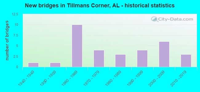
- New bridges - historical statistics
- 11940-1949
- 11950-1959
- 101960-1969
- 41970-1979
- 31980-1989
- 41990-1999
- 62000-2009
- 32010-2019
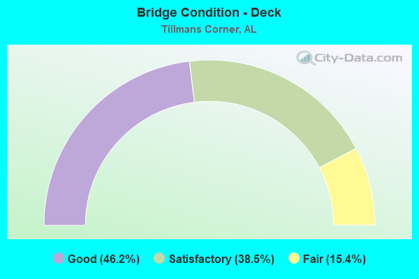
- Bridge Condition - Deck
- 46.2%Good
- 38.5%Satisfactory
- 15.4%Fair
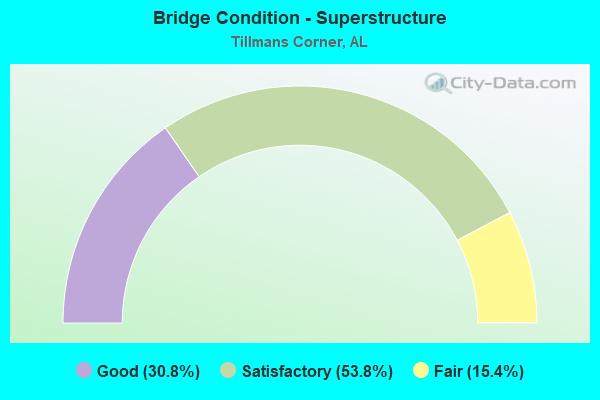
- Bridge Condition - Superstructure
- 30.8%Good
- 53.8%Satisfactory
- 15.4%Fair
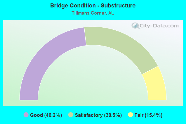
- Bridge Condition - Substructure
- 46.2%Good
- 38.5%Satisfactory
- 15.4%Fair
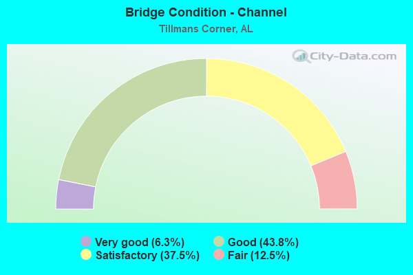
- Bridge Condition - Channel
- 6.3%Very good
- 43.8%Good
- 37.5%Satisfactory
- 12.5%Fair
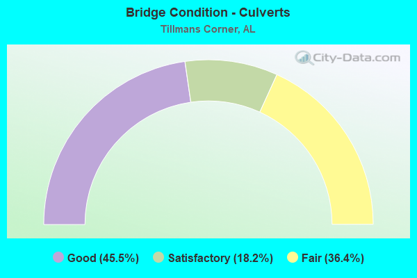
- Bridge Condition - Culverts
- 45.5%Good
- 18.2%Satisfactory
- 36.4%Fair
Find on map >> Show street view
Structure Number: 8113, Location: 0.1 MI E I-10 (Lat: 30.583400, Lng: -88.170167), Route carried "on" structure: US 90, Year Built: 1952, Year Reconstructed: 1964, Status: Open, Structure Length: 1.01m (3.31ft), Average Daily Traffic: 23,830 (year 2019), Truck Traffic: 2%, Average Future Daily Traffic: 35,745 (year 2039), Design Load: HS 20, Features Intersected: RATTLESNAKE BRANCH
Minimum Vertical Clearance: 30+ m (98+ ft), Kilometerpoint: 28.130, Lanes on structure: 4, Owner: State Highway Agency, Approaching Roadway Width: 14.9m (48.9ft), Skew: 20 degrees, Material/Design: Concrete, Design/Construction: Culvert, Number Of Spans In Main Unit: 3, Length of Maximum Span: 3.0m (9.8ft)
Condition: Channel: Satisfactory, Culverts: Fair, Operating Rating: 60.2 metric tons, Method Used To Determine Operating Rating: Load Factor (LF), Inventory Rating: 36.0 metric tons, Method Used To Determine Inventory Rating: Load Factor (LF), Structural Evaluation: Somewhat better than minimum adequacy, Waterway Adequacy: Equal to present minimum criteria, Approach Roadway Alignment: Equal to present desirable criteria, Length Of Structure Improvement: 1.68m (5.51ft), Designated Inspection Frequency: Every 24 months, Inspection Date: July 2020, Bridge Improvement Cost: $1,026,000, Roadway Improvement Cost: $103,000, Total Project Cost: $1,129,000 ( Estimate for 2022)
Find on map >> Show street view
Structure Number: 8124, Location: 8.4 MI E MISS ST LINE (Lat: 30.520600, Lng: -88.270811), Route carried "on" structure: Interstate 10, Year Built: 1964, Status: Open, Structure Length: 4.45m (14.60ft), Average Daily Traffic: 22,522 (year 2020), Truck Traffic: 28%, Average Future Daily Traffic: 33,783 (year 2040), Design Load: HS 20, Features Intersected: MARCH ROAD
Minimum Vertical Clearance: 30+ m (98+ ft), Kilometerpoint: 13.518, Lanes on structure: 2, Lanes under structure: 2, Base Highway Network: Yes, Owner: State Highway Agency, Approaching Roadway Width: 12.2m (40.0ft), Skew: 10 degrees, Material/Design: Concrete continuous, Design/Construction: Tee Beam, Number Of Spans In Main Unit: 3, Length of Maximum Span: 16.8m (55.1ft), Curb-To-Curb Width: 12.2m (40.0ft), Out-to-Out Width: 14.4m (47.2ft)
Condition: Deck: Fair, Superstructure: Fair, Substructure: Fair, Operating Rating: 52.5 metric tons, Method Used To Determine Operating Rating: Load Factor (LF), Inventory Rating: 31.5 metric tons, Method Used To Determine Inventory Rating: Load Factor (LF), Structural Evaluation: Somewhat better than minimum adequacy, Deck Geometry: Better than present minimum criteria, Underclear: Somewhat better than minimum adequacy, Approach Roadway Alignment: Equal to present desirable criteria, Length Of Structure Improvement: 5.44m (17.85ft), Designated Inspection Frequency: Every 24 months, Inspection Date: December 2021, Bridge Improvement Cost: $1,753,000, Roadway Improvement Cost: $175,000, Total Project Cost: $1,928,000 ( Estimate for 2022), Deck Structure Type: Concrete Cast-file-Place
Find on map >> Show street view
Structure Number: 8125, Location: 8.4 MI E MISS ST LINE (Lat: 30.520414, Lng: -88.270650), Route carried "on" structure: Interstate 10, Year Built: 1964, Status: Open, Structure Length: 4.45m (14.60ft), Average Daily Traffic: 22,522 (year 2020), Truck Traffic: 28%, Average Future Daily Traffic: 33,783 (year 2040), Design Load: HS 20, Features Intersected: MARCH ROAD
Minimum Vertical Clearance: 30+ m (98+ ft), Kilometerpoint: 13.518, Lanes on structure: 2, Lanes under structure: 2, Base Highway Network: Yes, Owner: State Highway Agency, Approaching Roadway Width: 12.2m (40.0ft), Skew: 10 degrees, Material/Design: Concrete continuous, Design/Construction: Tee Beam, Number Of Spans In Main Unit: 3, Length of Maximum Span: 16.8m (55.1ft), Curb-To-Curb Width: 12.2m (40.0ft), Out-to-Out Width: 14.4m (47.2ft)
Condition: Deck: Fair, Superstructure: Satisfactory, Substructure: Fair, Operating Rating: 52.5 metric tons, Method Used To Determine Operating Rating: Load Factor (LF), Inventory Rating: 31.5 metric tons, Method Used To Determine Inventory Rating: Load Factor (LF), Structural Evaluation: Somewhat better than minimum adequacy, Deck Geometry: Better than present minimum criteria, Underclear: Somewhat better than minimum adequacy, Approach Roadway Alignment: Equal to present desirable criteria, Length Of Structure Improvement: 5.44m (17.85ft), Designated Inspection Frequency: Every 24 months, Inspection Date: December 2021, Bridge Improvement Cost: $1,753,000, Roadway Improvement Cost: $175,000, Total Project Cost: $1,928,000 ( Estimate for 2022), Deck Structure Type: Concrete Cast-file-Place
Find on map >> Show street view
Structure Number: 8128, Location: 3.4 MI W US 90 (Lat: 30.550853, Lng: -88.214978), Route carried "on" structure: Interstate 10, Year Built: 1964, Status: Open, Structure Length: 0.76m (2.49ft), Average Daily Traffic: 27,272 (year 2020), Truck Traffic: 24%, Average Future Daily Traffic: 40,908 (year 2040), Design Load: HS 20, Features Intersected: HIGHLAND BRANCH
Minimum Vertical Clearance: 30+ m (98+ ft), Kilometerpoint: 19.837, Lanes on structure: 2, Base Highway Network: Yes, Owner: State Highway Agency, Approaching Roadway Width: 11.8m (38.7ft), Skew: 10 degrees, Material/Design: Concrete, Design/Construction: Culvert, Number Of Spans In Main Unit: 3, Length of Maximum Span: 2.4m (7.9ft)
Condition: Channel: Good, Culverts: Good, Operating Rating: 86.9 metric tons, Method Used To Determine Operating Rating: Load Factor (LF), Inventory Rating: 53.0 metric tons, Method Used To Determine Inventory Rating: Load Factor (LF), Structural Evaluation: Better than present minimum criteria, Waterway Adequacy: Better than present minimum criteria, Approach Roadway Alignment: Equal to present desirable criteria, Length Of Structure Improvement: 1.41m (4.63ft), Designated Inspection Frequency: Every 24 months, Inspection Date: December 2021, Bridge Improvement Cost: $490,000, Roadway Improvement Cost: $49,000, Total Project Cost: $539,000 ( Estimate for 2022)
Find on map >> Show street view
Structure Number: 8129, Location: 3.4 MI W US 90 (Lat: 30.549956, Lng: -88.215144), Route carried "on" structure: Interstate 10, Year Built: 1964, Status: Open, Structure Length: 0.76m (2.49ft), Average Daily Traffic: 27,272 (year 2020), Truck Traffic: 24%, Average Future Daily Traffic: 40,908 (year 2040), Design Load: HS 20, Features Intersected: HIGHLAND BRANCH
Minimum Vertical Clearance: 30+ m (98+ ft), Kilometerpoint: 19.755, Lanes on structure: 2, Base Highway Network: Yes, Owner: State Highway Agency, Approaching Roadway Width: 12.2m (40.0ft), Skew: 10 degrees, Material/Design: Concrete, Design/Construction: Culvert, Number Of Spans In Main Unit: 3, Length of Maximum Span: 2.4m (7.9ft)
Condition: Channel: Good, Culverts: Good, Operating Rating: 71.1 metric tons, Method Used To Determine Operating Rating: Load Factor (LF), Inventory Rating: 44.2 metric tons, Method Used To Determine Inventory Rating: Load Factor (LF), Structural Evaluation: Better than present minimum criteria, Waterway Adequacy: Equal to present minimum criteria, Approach Roadway Alignment: Equal to present desirable criteria, Length Of Structure Improvement: 1.41m (4.63ft), Designated Inspection Frequency: Every 24 months, Inspection Date: December 2021, Bridge Improvement Cost: $514,000, Roadway Improvement Cost: $51,000, Total Project Cost: $565,000 ( Estimate for 2022)
Find on map >> Show street view
Structure Number: 8131, Location: 1.4 MI W US 90 (Lat: 30.568853, Lng: -88.189867), Route carried "on" structure: Interstate 10, Year Built: 1964, Status: Open, Structure Length: 1.52m (4.99ft), Average Daily Traffic: 62,641 (year 2020), Truck Traffic: 21%, Average Future Daily Traffic: 93,962 (year 2040), Design Load: HS 20, Features Intersected: RABBIT CREEK
Minimum Vertical Clearance: 30+ m (98+ ft), Kilometerpoint: 22.956, Lanes on structure: 4, Base Highway Network: Yes, Owner: State Highway Agency, Approaching Roadway Width: 23.8m (78.1ft), Skew: 10 degrees, Material/Design: Concrete, Design/Construction: Culvert, Number Of Spans In Main Unit: 4, Length of Maximum Span: 3.7m (12.1ft)
Condition: Channel: Satisfactory, Culverts: Fair, Operating Rating: 88.9 metric tons, Method Used To Determine Operating Rating: Load Factor (LF), Inventory Rating: 88.9 metric tons, Method Used To Determine Inventory Rating: Load Factor (LF), Structural Evaluation: Somewhat better than minimum adequacy, Waterway Adequacy: Equal to present minimum criteria, Approach Roadway Alignment: Better than present minimum criteria, Length Of Structure Improvement: 2.20m (7.22ft), Designated Inspection Frequency: Every 24 months, Inspection Date: Febuary 2022, Bridge Improvement Cost: $2,826,000, Roadway Improvement Cost: $283,000, Total Project Cost: $3,109,000 ( Estimate for 2022)
Find on map >> Show street view
Structure Number: 8137, Location: 0.4 MI E US 90 (Lat: 30.583781, Lng: -88.165017), Route carried "on" structure: Interstate 10, Year Built: 1964, Status: Open, Structure Length: 1.13m (3.71ft), Average Daily Traffic: 72,338 (year 2020), Truck Traffic: 18%, Average Future Daily Traffic: 108,507 (year 2040), Design Load: HS 20, Features Intersected: RATTLESNAKE BRANCH
Minimum Vertical Clearance: 30+ m (98+ ft), Kilometerpoint: 25.864, Lanes on structure: 6, Base Highway Network: Yes, Owner: State Highway Agency, Approaching Roadway Width: 41.4m (135.8ft), Skew: 20 degrees, Material/Design: Concrete, Design/Construction: Culvert, Number Of Spans In Main Unit: 3, Length of Maximum Span: 3.7m (12.1ft)
Condition: Channel: Fair, Culverts: Fair, Operating Rating: 88.9 metric tons, Method Used To Determine Operating Rating: Load Factor (LF), Inventory Rating: 88.9 metric tons, Method Used To Determine Inventory Rating: Load Factor (LF), Structural Evaluation: Somewhat better than minimum adequacy, Waterway Adequacy: Equal to present desirable criteria, Approach Roadway Alignment: Equal to present desirable criteria, Length Of Structure Improvement: 1.80m (5.91ft), Designated Inspection Frequency: Every 24 months, Inspection Date: December 2021, Bridge Improvement Cost: $1,695,000, Roadway Improvement Cost: $170,000, Total Project Cost: $1,865,000 ( Estimate for 2022)
Find on map >> Show street view
Structure Number: 8138, Location: 3 MI E US 90 (Lat: 30.614025, Lng: -88.140006), Route carried "on" structure: Interstate 10, Year Built: 1964, Status: Open, Structure Length: 0.76m (2.49ft), Average Daily Traffic: 88,617 (year 2020), Truck Traffic: 11%, Average Future Daily Traffic: 132,926 (year 2040), Design Load: HS 20, Features Intersected: BRANCH
Minimum Vertical Clearance: 30+ m (98+ ft), Kilometerpoint: 29.942, Lanes on structure: 6, Base Highway Network: Yes, Owner: State Highway Agency, Approaching Roadway Width: 37.2m (122.0ft), Skew: 23 degrees, Material/Design: Concrete, Design/Construction: Culvert, Number Of Spans In Main Unit: 2, Length of Maximum Span: 3.7m (12.1ft)
Condition: Channel: Satisfactory, Culverts: Fair, Operating Rating: 88.9 metric tons, Method Used To Determine Operating Rating: Load Factor (LF), Inventory Rating: 74.1 metric tons, Method Used To Determine Inventory Rating: Load Factor (LF), Structural Evaluation: Somewhat better than minimum adequacy, Waterway Adequacy: Better than present minimum criteria, Approach Roadway Alignment: Equal to present desirable criteria, Length Of Structure Improvement: 1.41m (4.63ft), Designated Inspection Frequency: Every 24 months, Inspection Date: December 2021, Bridge Improvement Cost: $1,787,000, Roadway Improvement Cost: $179,000, Total Project Cost: $1,966,000 ( Estimate for 2022)
Find on map >> Show street view
Structure Number: 12228, Location: TILLMAN'S CORNER (Lat: 30.595386, Lng: -88.153856), Route carried "on" structure: State highway 193, Year Built: 1979, Status: Open, Structure Length: 12.13m (39.80ft), Average Daily Traffic: 12,104 (year 2019), Truck Traffic: 5%, Average Future Daily Traffic: 18,155 (year 2039), Design Load: HS 20, Features Intersected: I-10
Minimum Vertical Clearance: 30+ m (98+ ft), Kilometerpoint: 40.049, Lanes on structure: 3, Lanes under structure: 8, Owner: State Highway Agency, Approaching Roadway Width: 15.8m (51.8ft), Skew: 11 degrees, Material/Design: Steel continuous, Design/Construction: Stringer/Multi-beam, Number Of Spans In Main Unit: 4, Length of Maximum Span: 38.7m (127.0ft), Curb-To-Curb Width: 15.8m (51.8ft), Out-to-Out Width: 16.7m (54.8ft)
Condition: Deck: Satisfactory, Superstructure: Satisfactory, Substructure: Satisfactory, Operating Rating: 65.8 metric tons, Method Used To Determine Operating Rating: Load Factor (LF), Inventory Rating: 39.4 metric tons, Method Used To Determine Inventory Rating: Load Factor (LF), Structural Evaluation: Equal to present minimum criteria, Deck Geometry: Better than present minimum criteria, Underclear: High priority of corrective action, Approach Roadway Alignment: Better than present minimum criteria, Length Of Structure Improvement: 12.98m (42.59ft), Designated Inspection Frequency: Every 24 months, Inspection Date: September 2020, Bridge Improvement Cost: $4,806,000, Roadway Improvement Cost: $481,000, Total Project Cost: $5,287,000 ( Estimate for 2022), Deck Structure Type: Concrete Cast-file-Place
Find on map >> Show street view
Structure Number: 12229, Location: TILLMAN'S CORNER (Lat: 30.595544, Lng: -88.153753), Route carried "on" structure: State highway 193, Year Built: 1979, Status: Open, Structure Length: 12.13m (39.80ft), Average Daily Traffic: 12,104 (year 2019), Truck Traffic: 5%, Average Future Daily Traffic: 18,155 (year 2039), Design Load: HS 20, Features Intersected: I-10
Minimum Vertical Clearance: 30+ m (98+ ft), Kilometerpoint: 40.055, Lanes on structure: 3, Lanes under structure: 8, Owner: State Highway Agency, Approaching Roadway Width: 15.8m (51.8ft), Skew: 11 degrees, Material/Design: Steel continuous, Design/Construction: Stringer/Multi-beam, Number Of Spans In Main Unit: 4, Length of Maximum Span: 38.7m (127.0ft), Curb-To-Curb Width: 15.8m (51.8ft), Out-to-Out Width: 16.7m (54.8ft)
Condition: Deck: Satisfactory, Superstructure: Good, Substructure: Satisfactory, Operating Rating: 65.8 metric tons, Method Used To Determine Operating Rating: Load Factor (LF), Inventory Rating: 39.4 metric tons, Method Used To Determine Inventory Rating: Load Factor (LF), Structural Evaluation: Equal to present minimum criteria, Deck Geometry: Better than present minimum criteria, Underclear: High priority of corrective action, Approach Roadway Alignment: Better than present minimum criteria, Length Of Structure Improvement: 12.98m (42.59ft), Designated Inspection Frequency: Every 24 months, Inspection Date: September 2020, Bridge Improvement Cost: $4,806,000, Roadway Improvement Cost: $481,000, Total Project Cost: $5,287,000 ( Estimate for 2022), Deck Structure Type: Concrete Cast-file-Place
Find on map >> Show street view
Structure Number: 12573, Location: 0.8 MI E OF COUNTY RD 39 (Lat: 30.555331, Lng: -88.234483), Route carried "on" structure: County highway 28, Year Built: 1981, Status: Open, Structure Length: 3.66m (12.01ft), Average Daily Traffic: 7,086 (year 2020), Truck Traffic: 5%, Average Future Daily Traffic: 10,529 (year 2040), Design Load: H 15, Features Intersected: FOWL RIVER, Facility Carried by Structure: OLD PASCAGOULA RD
Minimum Vertical Clearance: 30+ m (98+ ft), Kilometerpoint: 0.800, Lanes on structure: 2, Owner: County Highway Agency, Approaching Roadway Width: 7.5m (24.6ft), Material/Design: Concrete, Design/Construction: Channel Beam, Number Of Spans In Main Unit: 5, Length of Maximum Span: 7.3m (24.0ft), Curb or Sidewalk Widths: Left: 0.3m (1.0ft), Right: 0.3m (1.0ft), Curb-To-Curb Width: 8.6m (28.2ft), Out-to-Out Width: 8.6m (28.2ft)
Condition: Deck: Good, Superstructure: Satisfactory, Substructure: Satisfactory, Channel: Satisfactory, Operating Rating: 49.1 metric tons, Method Used To Determine Operating Rating: Load Factor (LF), Inventory Rating: 29.5 metric tons, Method Used To Determine Inventory Rating: Load Factor (LF), Structural Evaluation: Equal to present minimum criteria, Deck Geometry: High priority of replacement, Waterway Adequacy: Better than present minimum criteria, Approach Roadway Alignment: Better than present minimum criteria, Length Of Structure Improvement: 4.58m (15.03ft), Designated Inspection Frequency: Every 24 months, Underwater Inspection Frequency: Every 24 months, Inspection Date: May 2020, Underwater Inspection Date: May 2020, Bridge Improvement Cost: $879,000, Roadway Improvement Cost: $88,000, Total Project Cost: $967,000 ( Estimate for 2022), Deck Structure Type: Concrete Precast Panels, Wearing Surface/Protective System: Wearing Surface: Bituminous
Find on map >> Show street view
Structure Number: 12574, Location: 1.7 MI W HWY 90 (Lat: 30.573344, Lng: -88.193264), Route carried "on" structure: County highway 28, Year Built: 1981, Status: Open, Structure Length: 2.19m (7.19ft), Average Daily Traffic: 7,418 (year 2020), Truck Traffic: 1%, Average Future Daily Traffic: 11,023 (year 2040), Design Load: HS 20, Features Intersected: RABBIT CREEK, Facility Carried by Structure: OLD PASCAGOULA RD
Minimum Vertical Clearance: 30+ m (98+ ft), Kilometerpoint: 0.010, Lanes on structure: 2, Owner: County Highway Agency, Approaching Roadway Width: 8.8m (28.9ft), Material/Design: Concrete, Design/Construction: Channel Beam, Number Of Spans In Main Unit: 3, Length of Maximum Span: 7.3m (24.0ft), Curb or Sidewalk Widths: Left: 0.3m (1.0ft), Right: 0.3m (1.0ft), Curb-To-Curb Width: 8.6m (28.2ft), Out-to-Out Width: 8.6m (28.2ft)
Condition: Deck: Satisfactory, Superstructure: Satisfactory, Substructure: Satisfactory, Channel: Good, Operating Rating: 62.8 metric tons, Method Used To Determine Operating Rating: Load Factor (LF), Inventory Rating: 37.6 metric tons, Method Used To Determine Inventory Rating: Load Factor (LF), Structural Evaluation: Equal to present minimum criteria, Deck Geometry: High priority of replacement, Waterway Adequacy: Better than present minimum criteria, Approach Roadway Alignment: Better than present minimum criteria, Length Of Structure Improvement: 3.00m (9.84ft), Designated Inspection Frequency: Every 24 months, Underwater Inspection Frequency: Every 24 months, Inspection Date: May 2020, Underwater Inspection Date: May 2020, Bridge Improvement Cost: $575,000, Roadway Improvement Cost: $58,000, Total Project Cost: $633,000 ( Estimate for 2022), Deck Structure Type: Concrete Precast Panels, Wearing Surface/Protective System: Wearing Surface: Bituminous
Find on map >> Show street view
Structure Number: 14819, Location: 0.2 MI E. MCDONALD RD. (Lat: 30.579133, Lng: -88.237997), Route carried "on" structure: County highway 30000, Year Built: 1989, Status: Open, Structure Length: 1.13m (3.71ft), Average Daily Traffic: 3,821 (year 2020), Truck Traffic: 3%, Average Future Daily Traffic: 5,678 (year 2040), Design Load: HS 20, Features Intersected: FOWL RIVER, Facility Carried by Structure: THEODOREDAWES RD W
Minimum Vertical Clearance: 30+ m (98+ ft), Kilometerpoint: 0.010, Lanes on structure: 2, Owner: County Highway Agency, Approaching Roadway Width: 6.4m (21.0ft), Material/Design: Concrete continuous, Design/Construction: Culvert, Number Of Spans In Main Unit: 3, Length of Maximum Span: 3.7m (12.1ft), Curb-To-Curb Width: 12.1m (39.7ft), Out-to-Out Width: 12.1m (39.7ft)
Condition: Channel: Good, Culverts: Good, Operating Rating: 69.9 metric tons, Method Used To Determine Operating Rating: Load Factor (LF), Inventory Rating: 41.9 metric tons, Method Used To Determine Inventory Rating: Load Factor (LF), Structural Evaluation: Better than present minimum criteria, Deck Geometry: Somewhat better than minimum adequacy, Waterway Adequacy: Better than present minimum criteria, Approach Roadway Alignment: Equal to present minimum criteria, Length Of Structure Improvement: 1.81m (5.94ft), Designated Inspection Frequency: Every 24 months, Inspection Date: July 2020, Bridge Improvement Cost: $521,000, Roadway Improvement Cost: $52,000, Total Project Cost: $573,000 ( Estimate for 2022)
Find on map >> Show street view
Structure Number: 15785, Location: 1.2 MI. N. CO. 28 (Lat: 30.567833, Lng: -88.241997), Route carried "on" structure: County highway , Year Built: 1993, Status: Open, Structure Length: 0.85m (2.79ft), Average Daily Traffic: 7,303 (year 2020), Truck Traffic: 3%, Average Future Daily Traffic: 10,852 (year 2040), Design Load: HS 20, Features Intersected: CREEK, Facility Carried by Structure: MCDONALD ROAD
Minimum Vertical Clearance: 30.45m (99.90ft), Kilometerpoint: 1.199, Lanes on structure: 2, Owner: County Highway Agency, Approaching Roadway Width: 7.3m (24.0ft), Skew: 3 degrees, Material/Design: Concrete continuous, Design/Construction: Culvert, Number Of Spans In Main Unit: 2, Length of Maximum Span: 4.1m (13.5ft), Curb or Sidewalk Widths: Left: 0.2m (0.7ft), Right: 0.2m (0.7ft), Curb-To-Curb Width: 13.5m (44.3ft), Out-to-Out Width: 13.5m (44.3ft)
Condition: Channel: Satisfactory, Culverts: Satisfactory, Operating Rating: 88.9 metric tons, Method Used To Determine Operating Rating: Load Factor (LF), Inventory Rating: 55.0 metric tons, Method Used To Determine Inventory Rating: Load Factor (LF), Structural Evaluation: Equal to present minimum criteria, Deck Geometry: Superior to present desirable criteria, Waterway Adequacy: Equal to present desirable criteria, Approach Roadway Alignment: Better than present minimum criteria, Length Of Structure Improvement: 1.52m (4.99ft), Designated Inspection Frequency: Every 24 months, Inspection Date: July 2020, Bridge Improvement Cost: $491,000, Roadway Improvement Cost: $49,000, Total Project Cost: $540,000 ( Estimate for 2022)
Find on map >> Show street view
Structure Number: 17118, Location: 275 M S OF DAWES RD (Lat: 30.583806, Lng: -88.288267), Route carried "on" structure: County highway , Year Built: 1997, Status: Open, Structure Length: 0.63m (2.07ft), Average Daily Traffic: 416 (year 2020), Average Future Daily Traffic: 618 (year 2040), Design Load: HS 20, Features Intersected: BAKER CREEK, Facility Carried by Structure: WEAR RD
Minimum Vertical Clearance: 7.56m (24.80ft), Kilometerpoint: 0.010, Lanes on structure: 2, Owner: County Highway Agency, Approaching Roadway Width: 6.1m (20.0ft), Material/Design: Concrete continuous, Design/Construction: Culvert, Number Of Spans In Main Unit: 2, Length of Maximum Span: 3.0m (9.8ft)
Condition: Channel: Good, Culverts: Good, Operating Rating: 88.9 metric tons, Method Used To Determine Operating Rating: Load Factor (LF), Inventory Rating: 63.3 metric tons, Method Used To Determine Inventory Rating: Load Factor (LF), Structural Evaluation: Better than present minimum criteria, Waterway Adequacy: Better than present minimum criteria, Approach Roadway Alignment: Equal to present desirable criteria, Length Of Structure Improvement: 1.25m (4.10ft), Designated Inspection Frequency: Every 24 months, Inspection Date: September 2020, Bridge Improvement Cost: $353,000, Roadway Improvement Cost: $35,000, Total Project Cost: $388,000 ( Estimate for 2022)
Find on map >> Show street view
Structure Number: 17196, Location: 2.4 MI W US 90 (Lat: 30.559678, Lng: -88.202994), Route carried "on" structure: County highway 32, Year Built: 1999, Status: Open, Structure Length: 10.00m (32.81ft), Average Daily Traffic: 15,645 (year 2020), Truck Traffic: 4%, Average Future Daily Traffic: 23,468 (year 2040), Design Load: HS 20, Features Intersected: I-10, Facility Carried by Structure: THEODORE DAWES RD
Minimum Vertical Clearance: 30+ m (98+ ft), Kilometerpoint: 0.000, Lanes on structure: 6, Lanes under structure: 4, Owner: State Highway Agency, Approaching Roadway Width: 27.6m (90.6ft), Skew: 3 degrees, Material/Design: Prestressed concrete, Design/Construction: Stringer/Multi-beam, Number Of Spans In Main Unit: 4, Length of Maximum Span: 32.0m (105.0ft), Curb-To-Curb Width: 27.6m (90.6ft), Out-to-Out Width: 28.4m (93.2ft)
Condition: Deck: Good, Superstructure: Fair, Substructure: Good, Operating Rating: 73.4 metric tons, Method Used To Determine Operating Rating: Load Factor (LF), Inventory Rating: 33.1 metric tons, Method Used To Determine Inventory Rating: Load Factor (LF), Structural Evaluation: Somewhat better than minimum adequacy, Deck Geometry: Better than present minimum criteria, Underclear: Equal to present minimum criteria, Approach Roadway Alignment: Better than present minimum criteria, Length Of Structure Improvement: 10.93m (35.86ft), Designated Inspection Frequency: Every 24 months, Inspection Date: January 2022, Bridge Improvement Cost: $6,968,000, Roadway Improvement Cost: $697,000, Total Project Cost: $7,665,000 ( Estimate for 2022), Deck Structure Type: Concrete Cast-file-Place
Find on map >> Show street view
Structure Number: 17511, Location: 300' S HOLLY POINT DR S (Lat: 30.604114, Lng: -88.257414), Route carried "on" structure: County highway , Year Built: 1945, Status: Open, Structure Length: 0.62m (2.03ft), Average Daily Traffic: 3,415 (year 2020), Truck Traffic: 5%, Average Future Daily Traffic: 5,075 (year 2040), Design Load: HS 20, Features Intersected: BRANCH OF TURKEY CREEK, Facility Carried by Structure: DAWES RD
Minimum Vertical Clearance: 30+ m (98+ ft), Kilometerpoint: 0.000, Lanes on structure: 2, Owner: County Highway Agency, Approaching Roadway Width: 7.7m (25.3ft), Material/Design: Concrete continuous, Design/Construction: Culvert, Number Of Spans In Main Unit: 2, Length of Maximum Span: 3.0m (9.8ft)
Condition: Channel: Satisfactory, Culverts: Good, Operating Rating: 60.1 metric tons, Method Used To Determine Operating Rating: Load Factor (LF), Inventory Rating: 36.1 metric tons, Method Used To Determine Inventory Rating: Load Factor (LF), Structural Evaluation: Better than present minimum criteria, Waterway Adequacy: Better than present minimum criteria, Approach Roadway Alignment: Equal to present desirable criteria, Length Of Structure Improvement: 1.23m (4.04ft), Designated Inspection Frequency: Every 24 months, Inspection Date: September 2020, Bridge Improvement Cost: $298,000, Roadway Improvement Cost: $30,000, Total Project Cost: $328,000 ( Estimate for 2022)
Find on map >> Show street view
Structure Number: 1775, Location: 0.4 MI N. DAWES RD (Lat: 30.589656, Lng: -88.292419), Route carried "on" structure: County highway , Year Built: 2000, Status: Open, Structure Length: 3.65m (11.98ft), Average Daily Traffic: 371 (year 2020), Truck Traffic: 4%, Average Future Daily Traffic: 551 (year 2040), Design Load: HS 20, Features Intersected: BAKER CREEK, Facility Carried by Structure: BAIRD-COXWELL RD.
Minimum Vertical Clearance: 30+ m (98+ ft), Kilometerpoint: 0.299, Lanes on structure: 2, Toll: Toll bridge is a segment, Owner: County Highway Agency, Approaching Roadway Width: 6.7m (22.0ft), Material/Design: Concrete, Design/Construction: Channel Beam, Number Of Spans In Main Unit: 5, Length of Maximum Span: 7.3m (24.0ft), Curb or Sidewalk Widths: Left: 0.4m (1.3ft), Right: 0.4m (1.3ft), Curb-To-Curb Width: 8.5m (27.9ft), Out-to-Out Width: 9.3m (30.5ft)
Condition: Deck: Satisfactory, Superstructure: Satisfactory, Substructure: Satisfactory, Channel: Good, Operating Rating: 88.9 metric tons, Method Used To Determine Operating Rating: Load Factor (LF), Inventory Rating: 60.8 metric tons, Method Used To Determine Inventory Rating: Load Factor (LF), Structural Evaluation: Equal to present minimum criteria, Waterway Adequacy: Equal to present desirable criteria, Approach Roadway Alignment: Better than present minimum criteria, Length Of Structure Improvement: 4.57m (14.99ft), Designated Inspection Frequency: Every 24 months, Inspection Date: September 2020, Bridge Improvement Cost: $940,000, Roadway Improvement Cost: $94,000, Total Project Cost: $1,034,000 ( Estimate for 2022), Deck Structure Type: Concrete Precast Panels
Find on map >> Show street view
Structure Number: 18396, Location: 10.4 MI E MISS STATELINE (Lat: 30.537697, Lng: -88.240189), Route carried "on" structure: County highway 39, Year Built: 2005, Status: Open, Structure Length: 13.41m (44.00ft), Average Daily Traffic: 5,230 (year 2020), Truck Traffic: 4%, Average Future Daily Traffic: 7,845 (year 2040), Design Load: HS 20, Features Intersected: I-10
Minimum Vertical Clearance: 30+ m (98+ ft), Kilometerpoint: 0.161, Lanes on structure: 3, Lanes under structure: 6, Owner: State Highway Agency, Approaching Roadway Width: 14.7m (48.2ft), Material/Design: Prestressed concrete continuous, Design/Construction: Stringer/Multi-beam, Number Of Spans In Main Unit: 4, Length of Maximum Span: 36.6m (120.1ft), Curb-To-Curb Width: 15.8m (51.8ft), Out-to-Out Width: 16.7m (54.8ft)
Condition: Deck: Satisfactory, Superstructure: Satisfactory, Substructure: Good, Operating Rating: 72.8 metric tons, Method Used To Determine Operating Rating: Load Factor (LF), Inventory Rating: 47.6 metric tons, Method Used To Determine Inventory Rating: Load Factor (LF), Structural Evaluation: Equal to present minimum criteria, Deck Geometry: Better than present minimum criteria, Underclear: Equal to present minimum criteria, Approach Roadway Alignment: Better than present minimum criteria, Length Of Structure Improvement: 14.22m (46.65ft), Designated Inspection Frequency: Every 24 months, Inspection Date: December 2021, Bridge Improvement Cost: $5,266,000, Roadway Improvement Cost: $527,000, Total Project Cost: $5,793,000 ( Estimate for 2022), Deck Structure Type: Concrete Cast-file-Place
Find on map >> Show street view
Structure Number: 18397, Location: 10.4 MI E MISS.STATE LINE (Lat: 30.537842, Lng: -88.239900), Route carried "on" structure: County highway 39, Year Built: 2004, Status: Open, Structure Length: 13.41m (44.00ft), Average Daily Traffic: 5,230 (year 2020), Truck Traffic: 4%, Average Future Daily Traffic: 7,245 (year 2040), Design Load: HS 20, Features Intersected: I-10
Minimum Vertical Clearance: 30+ m (98+ ft), Kilometerpoint: 0.161, Lanes on structure: 3, Lanes under structure: 6, Owner: State Highway Agency, Approaching Roadway Width: 14.9m (48.9ft), Material/Design: Prestressed concrete continuous, Design/Construction: Stringer/Multi-beam, Number Of Spans In Main Unit: 4, Length of Maximum Span: 36.6m (120.1ft), Curb-To-Curb Width: 15.8m (51.8ft), Out-to-Out Width: 16.7m (54.8ft)
Condition: Deck: Good, Superstructure: Satisfactory, Substructure: Good, Operating Rating: 72.8 metric tons, Method Used To Determine Operating Rating: Load Factor (LF), Inventory Rating: 47.6 metric tons, Method Used To Determine Inventory Rating: Load Factor (LF), Structural Evaluation: Equal to present minimum criteria, Deck Geometry: Better than present minimum criteria, Underclear: Equal to present minimum criteria, Approach Roadway Alignment: Equal to present desirable criteria, Length Of Structure Improvement: 14.22m (46.65ft), Designated Inspection Frequency: Every 24 months, Inspection Date: December 2021, Bridge Improvement Cost: $5,266,000, Roadway Improvement Cost: $527,000, Total Project Cost: $5,793,000 ( Estimate for 2022), Deck Structure Type: Concrete Cast-file-Place
Find on map >> Show street view
Structure Number: 19381, Location: .2MI. W. OF MCDONALD RD (Lat: 30.574364, Lng: -88.244842), Route carried "on" structure: County highway , Year Built: 2003, Status: Open, Structure Length: 1.04m (3.41ft), Average Daily Traffic: 1,491 (year 2020), Truck Traffic: 4%, Average Future Daily Traffic: 2,216 (year 2040), Design Load: HS 20, Features Intersected: PRIVATE LAKE SPILLWAY, Facility Carried by Structure: BELMONT PARK DRIVE
Minimum Vertical Clearance: 30+ m (98+ ft), Kilometerpoint: 0.000, Lanes on structure: 2, Owner: County Highway Agency, Approaching Roadway Width: 6.6m (21.7ft), Material/Design: Concrete, Design/Construction: Channel Beam, Number Of Spans In Main Unit: 1, Length of Maximum Span: 10.4m (34.1ft), Curb-To-Curb Width: 7.5m (24.6ft), Out-to-Out Width: 7.5m (24.6ft)
Condition: Deck: Good, Superstructure: Good, Substructure: Good, Channel: Good, Operating Rating: 51.5 metric tons, Method Used To Determine Operating Rating: Load Factor (LF), Inventory Rating: 30.8 metric tons, Method Used To Determine Inventory Rating: Load Factor (LF), Structural Evaluation: Better than present minimum criteria, Deck Geometry: Meets minimum limits, Waterway Adequacy: Better than present minimum criteria, Approach Roadway Alignment: Better than present minimum criteria, Length Of Structure Improvement: 1.71m (5.61ft), Designated Inspection Frequency: Every 24 months, Inspection Date: July 2020, Bridge Improvement Cost: $281,000, Roadway Improvement Cost: $28,000, Total Project Cost: $309,000 ( Estimate for 2022), Deck Structure Type: Concrete Precast Panels
Find on map >> Show street view
Structure Number: 19832, Location: I-10 @ US 90 INTERCHANGE (Lat: 30.580683, Lng: -88.170850), Route carried "on" structure: Interstate 10, Year Built: 2012, Status: Open, Structure Length: 9.75m (31.99ft), Average Daily Traffic: 79,008 (year 2018), Truck Traffic: 21%, Average Future Daily Traffic: 118,512 (year 2038), Design Load: HS 20, Features Intersected: US 90 EBL * WBL
Minimum Vertical Clearance: 30+ m (98+ ft), Kilometerpoint: 25.209, Lanes on structure: 2, Lanes under structure: 8, Base Highway Network: Yes, Owner: State Highway Agency, Approaching Roadway Width: 11.0m (36.1ft), Skew: 33 degrees, Material/Design: Prestressed concrete continuous, Design/Construction: Stringer/Multi-beam, Number Of Spans In Main Unit: 4, Length of Maximum Span: 27.4m (89.9ft), Curb-To-Curb Width: 11.6m (38.1ft), Out-to-Out Width: 12.8m (42.0ft)
Condition: Deck: Good, Superstructure: Good, Substructure: Good, Operating Rating: 88.9 metric tons, Method Used To Determine Operating Rating: Load Factor (LF), Inventory Rating: 46.2 metric tons, Method Used To Determine Inventory Rating: Load Factor (LF), Structural Evaluation: Better than present minimum criteria, Deck Geometry: Equal to present minimum criteria, Underclear: High priority of corrective action, Approach Roadway Alignment: Better than present minimum criteria, Length Of Structure Improvement: 10.69m (35.07ft), Designated Inspection Frequency: Every 24 months, Inspection Date: June 2020, Bridge Improvement Cost: $3,080,000, Roadway Improvement Cost: $308,000, Total Project Cost: $3,388,000 ( Estimate for 2022), Deck Structure Type: Concrete Cast-file-Place
Find on map >> Show street view
Structure Number: 20225, Location: .3 MILES S. OF MARCH RD. (Lat: 30.569778, Lng: -88.288722), Route carried "on" structure: County highway 34, Year Built: 1964, Status: Open, Structure Length: 0.94m (3.08ft), Average Daily Traffic: 1,456 (year 2020), Truck Traffic: 3%, Average Future Daily Traffic: 2,164 (year 2040), Design Load: HS 20, Features Intersected: TRIB. TO BAKER CREEK, Facility Carried by Structure: BEN HAMILTON ROAD
Minimum Vertical Clearance: 30+ m (98+ ft), Kilometerpoint: 0.000, Lanes on structure: 2, Owner: County Highway Agency, Approaching Roadway Width: 7.3m (24.0ft), Material/Design: Concrete, Design/Construction: Culvert, Number Of Spans In Main Unit: 3, Length of Maximum Span: 3.0m (9.8ft)
Condition: Channel: Fair, Culverts: Satisfactory, Operating Rating: 35.7 metric tons, Method Used To Determine Operating Rating: Load Factor (LF), Inventory Rating: 21.5 metric tons, Method Used To Determine Inventory Rating: Load Factor (LF), Structural Evaluation: Somewhat better than minimum adequacy, Waterway Adequacy: Better than present minimum criteria, Approach Roadway Alignment: Equal to present desirable criteria, Length Of Structure Improvement: 1.62m (5.31ft), Designated Inspection Frequency: Every 24 months, Inspection Date: September 2020, Bridge Improvement Cost: $393,000, Roadway Improvement Cost: $39,000, Total Project Cost: $432,000 ( Estimate for 2022)
Find on map >> Show street view
Structure Number: 20959, Location: 0.3 Miles North of I-10 (Lat: 30.524097, Lng: -88.273658), Route carried "on" structure: County highway 17, Year Built: 2014, Status: Open, Structure Length: 3.66m (12.01ft), Average Daily Traffic: 1,423 (year 2020), Truck Traffic: 1%, Average Future Daily Traffic: 2,115 (year 2040), Design Load: HS 20, Features Intersected: Jackson Creek, Facility Carried by Structure: March Road
Minimum Vertical Clearance: 30.45m (99.90ft), Kilometerpoint: 0.299, Lanes on structure: 2, Owner: County Highway Agency, Approaching Roadway Width: 7.3m (24.0ft), Material/Design: Concrete, Design/Construction: Channel Beam, Number Of Spans In Main Unit: 3, Length of Maximum Span: 12.2m (40.0ft), Curb-To-Curb Width: 7.3m (24.0ft), Out-to-Out Width: 8.6m (28.2ft)
Condition: Deck: Good, Superstructure: Good, Substructure: Good, Channel: Very good, Operating Rating: 88.9 metric tons, Method Used To Determine Operating Rating: Load Factor (LF), Inventory Rating: 55.1 metric tons, Method Used To Determine Inventory Rating: Load Factor (LF), Structural Evaluation: Better than present minimum criteria, Deck Geometry: High priority of replacement, Waterway Adequacy: Better than present minimum criteria, Approach Roadway Alignment: Better than present minimum criteria, Length Of Structure Improvement: 4.58m (15.03ft), Designated Inspection Frequency: Every 24 months, Underwater Inspection Frequency: Every 24 months, Inspection Date: July 2020, Underwater Inspection Date: July 2020, Bridge Improvement Cost: $880,000, Roadway Improvement Cost: $88,000, Total Project Cost: $968,000 ( Estimate for 2022)
Find on map >> Show street view
Structure Number: 8124, Location: 8.4 MI E MISS ST LINE (Lat: 30.520600, Lng: -88.270811), Route carried "under" structure: County highway 17, Year Built: 1964, Structure Length: 0. m, Average Daily Traffic: 1,958 (year 2020), Truck Traffic: 1%, Features Intersected: MARCH ROAD, Facility Carried by Structure: I-10 WB
Minimum Vertical Clearance: 5.11m (16.77ft), Kilometerpoint: 0.000, Lanes on structure: 2, Lanes under structure: 2, Material/Design: Concrete continuous, Design/Construction: Tee Beam, Length of Maximum Span: 16.8m (55.1ft)
Find on map >> Show street view
Structure Number: 8125, Location: 8.4 MI E MISS ST LINE (Lat: 30.520414, Lng: -88.270650), Route carried "under" structure: County highway 17, Year Built: 1964, Structure Length: 0. m, Average Daily Traffic: 2,006 (year 2020), Truck Traffic: 1%, Features Intersected: MARCH ROAD, Facility Carried by Structure: I-10 EB
Minimum Vertical Clearance: 4.93m (16.17ft), Kilometerpoint: 0.000, Lanes on structure: 2, Lanes under structure: 2, Material/Design: Concrete continuous, Design/Construction: Tee Beam, Length of Maximum Span: 16.8m (55.1ft)
Find on map >> Show street view
Structure Number: 12228, Location: TILLMAN'S CORNER (Lat: 30.595386, Lng: -88.153856), Route carried "under" structure: Interstate 10, Year Built: 1979, Structure Length: 0. m, Average Daily Traffic: 96,787 (year 2019), Truck Traffic: 11%, Features Intersected: I-10, Facility Carried by Structure: SR 193 SB
Minimum Vertical Clearance: 5.17m (16.96ft), Kilometerpoint: 28.199, Lanes on structure: 3, Lanes under structure: 8, Material/Design: Steel continuous, Design/Construction: Stringer/Multi-beam, Length of Maximum Span: 38.7m (127.0ft)
Find on map >> Show street view
Structure Number: 12229, Location: TILLMAN'S CORNER (Lat: 30.595544, Lng: -88.153753), Route carried "under" structure: Interstate 10, Year Built: 1979, Structure Length: 0. m, Average Daily Traffic: 96,787 (year 2019), Truck Traffic: 11%, Features Intersected: I-10, Facility Carried by Structure: SR 193 NB
Minimum Vertical Clearance: 5.32m (17.45ft), Kilometerpoint: 28.199, Lanes on structure: 3, Lanes under structure: 8, Material/Design: Steel continuous, Design/Construction: Stringer/Multi-beam, Length of Maximum Span: 38.7m (127.0ft)
Find on map >> Show street view
Structure Number: 17196, Location: 2.4 MI W US 90 (Lat: 30.559678, Lng: -88.202994), Route carried "under" structure: Interstate 10, Year Built: 1999, Structure Length: 0. m, Average Daily Traffic: 54,543 (year 2020), Truck Traffic: 24%, Features Intersected: I-10, Facility Carried by Structure: THEODORE DAWES RD
Minimum Vertical Clearance: 5.12m (16.80ft), Kilometerpoint: 21.388, Lanes on structure: 6, Lanes under structure: 4, Material/Design: Prestressed concrete, Design/Construction: Stringer/Multi-beam, Length of Maximum Span: 32.0m (105.0ft)
Find on map >> Show street view
Structure Number: 18396, Location: 10.4 MI E MISS STATELINE (Lat: 30.537697, Lng: -88.240189), Route carried "under" structure: Interstate 10, Year Built: 2005, Structure Length: 0. m, Average Daily Traffic: 45,043 (year 2020), Truck Traffic: 28%, Features Intersected: I-10, Facility Carried by Structure: CO RD 39 SB
Minimum Vertical Clearance: 5.37m (17.62ft), Kilometerpoint: 16.708, Lanes on structure: 3, Lanes under structure: 3, Material/Design: Prestressed concrete continuous, Design/Construction: Stringer/Multi-beam, Length of Maximum Span: 36.6m (120.1ft)
Find on map >> Show street view
Structure Number: 18397, Location: 10.4 MI E MISS.STATE LINE (Lat: 30.537842, Lng: -88.239900), Route carried "under" structure: Interstate 10, Year Built: 2004, Structure Length: 0. m, Average Daily Traffic: 45,043 (year 2020), Truck Traffic: 28%, Features Intersected: I-10, Facility Carried by Structure: CO RD 39 NB
Minimum Vertical Clearance: 5.81m (19.06ft), Kilometerpoint: 16.708, Lanes on structure: 3, Lanes under structure: 3, Material/Design: Prestressed concrete continuous, Design/Construction: Stringer/Multi-beam, Length of Maximum Span: 36.6m (120.1ft)
Find on map >> Show street view
Structure Number: 19832, Location: I-10 @ US 90 INTERCHANGE (Lat: 30.580683, Lng: -88.170850), Route carried "under" structure: US 90, Year Built: 2012, Structure Length: 0. m, Average Daily Traffic: 26,302 (year 2018), Truck Traffic: 5%, Features Intersected: US 90 EBL * WBL, Facility Carried by Structure: I-10 EBL * WBL
Minimum Vertical Clearance: 4.86m (15.94ft), Kilometerpoint: 27.969, Lanes on structure: 2, Lanes under structure: 8, Material/Design: Prestressed concrete continuous, Design/Construction: Stringer/Multi-beam, Length of Maximum Span: 27.4m (89.9ft)