Bridge Statistics for Tinicum Township, Pennsylvania (PA)
Condition, Traffic, Stress, Structural Evaluation, Project Costs
- National Bridge Inventory (NBI) Statistics
- 16Number of bridges
- 725ft / 221mTotal length
- $7,334,000Total costs
- 426,416Total average daily traffic
- 35,677Total average daily truck traffic
- National Bridge Inventory (NBI) Registered Bridges for Tinicum Township
- No street view available for this location
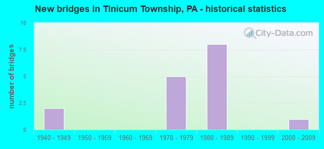
- New bridges - historical statistics
- 21940-1949
- 51970-1979
- 81980-1989
- 12000-2009

- Reconstructed bridges - Historical Statistics
- 12000-2009
- 12010-2019


- Bridge Condition - Deck
- 16.7%Very good
- 16.7%Good
- 50.0%Satisfactory
- 16.7%Fair

- Bridge Condition - Superstructure
- 16.7%Very good
- 50.0%Satisfactory
- 16.7%Fair
- 16.7%Poor

- Bridge Condition - Substructure
- 16.7%Good
- 50.0%Satisfactory
- 16.7%Fair
- 16.7%Poor

- Bridge Condition - Channel
- 33.3%Very good
- 33.3%Good
- 33.3%Satisfactory
Find on map >> Show street view
Structure Number: 14936, Location: NR.SCOTTS PAPER 36B13 (Lat: 39.875750, Lng: -75.271797), Route carried "on" structure: Interstate 95, Year Built: 1983, Year Reconstructed: 2010, Status: Open, Structure Length: 90.16m (295.80ft), Average Daily Traffic: 65,514 (year 2022), Truck Traffic: 8%, Average Future Daily Traffic: 72,240 (year 2032), Design Load: HS 20+Mod, Features Intersected: RELOC.BARTRAM AV;CONRAIL
Minimum Vertical Clearance: 5.48m (17.98ft), Kilometerpoint: 17.090, Lanes on structure: 4, Lanes under structure: 4, Base Highway Network: Yes, Owner: State Highway Agency, Approaching Roadway Width: 23.8m (78.1ft), Skew: 10 degrees, Material/Design: Steel continuous, Design/Construction: Stringer/Multi-beam, Number Of Spans In Main Unit: 9, Number Of Approach Spans: 17, Length of Maximum Span: 48.2m (158.1ft), Curb or Sidewalk Widths: Left: 0.2m (0.7ft), Right: 0.2m (0.7ft), Curb-To-Curb Width: 22.6m (74.1ft), Out-to-Out Width: 23.6m (77.4ft)
Condition: Deck: Satisfactory, Superstructure: Satisfactory, Substructure: Satisfactory, Operating Rating: 61.7 metric tons, Method Used To Determine Operating Rating: Load Factor (LF), Inventory Rating: 29.0 metric tons, Method Used To Determine Inventory Rating: Load Factor (LF), Structural Evaluation: Equal to present minimum criteria, Deck Geometry: Superior to present desirable criteria, Underclear: Superior to present desirable criteria, Waterway Adequacy: Superior to present desirable criteria, Approach Roadway Alignment: Equal to present desirable criteria, Length Of Structure Improvement: 91.30m (299.54ft), Designated Inspection Frequency: Every 24 months, Critical Feature Inspection Frequency: Every 24 months, Inspection Date: June 2020, Critical Feature Inspection Date: June 2020, Deck Structure Type: Concrete Cast-file-Place, Wearing Surface/Protective System: Wearing Surface: Monolithic Concrete, Deck Protection: Galvanized Reinforcing
Find on map >> Show street view
Structure Number: 14938, Location: NR.SCOTTS PAPER 36B13 (Lat: 39.876139, Lng: -75.271861), Route carried "on" structure: Interstate 95, Year Built: 1983, Status: Open, Structure Length: 92.63m (303.90ft), Average Daily Traffic: 77,157 (year 2022), Truck Traffic: 8%, Average Future Daily Traffic: 81,749 (year 2032), Design Load: HS 20+Mod, Features Intersected: RELOC.BARTRAM AV;CONRAIL
Minimum Vertical Clearance: 30+ m (98+ ft), Kilometerpoint: 17.151, Lanes on structure: 4, Lanes under structure: 4, Base Highway Network: Yes, Owner: State Highway Agency, Approaching Roadway Width: 23.8m (78.1ft), Skew: 10 degrees, Material/Design: Steel continuous, Design/Construction: Stringer/Multi-beam, Number Of Spans In Main Unit: 7, Number Of Approach Spans: 21, Length of Maximum Span: 49.7m (163.1ft), Curb-To-Curb Width: 22.6m (74.1ft), Out-to-Out Width: 23.6m (77.4ft)
Condition: Deck: Satisfactory, Superstructure: Satisfactory, Substructure: Good, Operating Rating: 65.3 metric tons, Method Used To Determine Operating Rating: Load Factor (LF), Inventory Rating: 26.3 metric tons, Method Used To Determine Inventory Rating: Load Factor (LF), Structural Evaluation: Equal to present minimum criteria, Deck Geometry: Superior to present desirable criteria, Underclear: High priority of corrective action, Waterway Adequacy: Superior to present desirable criteria, Approach Roadway Alignment: Equal to present desirable criteria, Length Of Structure Improvement: 93.80m (307.74ft), Designated Inspection Frequency: Every 24 months, Critical Feature Inspection Frequency: Every 24 months, Inspection Date: June 2020, Critical Feature Inspection Date: June 2020, Deck Structure Type: Concrete Cast-file-Place, Wearing Surface/Protective System: Wearing Surface: Monolithic Concrete, Deck Protection: Galvanized Reinforcing
Find on map >> Show street view
Structure Number: 14959, Location: TINICUM TWP LINE 44D02 (Lat: 39.866353, Lng: -75.313389), Route carried "on" structure: State highway 291, Year Built: 1943, Year Reconstructed: 2014, Status: Open, Structure Length: 10.00m (32.81ft), Average Daily Traffic: 15,275 (year 2022), Truck Traffic: 10%, Average Future Daily Traffic: 19,218 (year 2032), Design Load: HL 93, Features Intersected: DARBY CREEK, Facility Carried by Structure: GOVERNOR PRINTZ BL
Minimum Vertical Clearance: 30+ m (98+ ft), Kilometerpoint: 8.837, Lanes on structure: 4, Owner: State Highway Agency, Approaching Roadway Width: 16.8m (55.1ft), Skew: 20 degrees, Navigation Control: Yes ( Vertical Clearance: 999.7m (3,279.9ft), Horizontal Clearance: 9999.9m (32,808.1ft)), Material/Design: Steel continuous, Design/Construction: Stringer/Multi-beam, Number Of Spans In Main Unit: 5, Length of Maximum Span: 25.9m (85.0ft), Curb or Sidewalk Widths: Left: 0.0m, Right: 2.4m (7.9ft), Curb-To-Curb Width: 16.8m (55.1ft), Out-to-Out Width: 20.2m (66.3ft)
Condition: Deck: Very good, Superstructure: Very good, Substructure: Satisfactory, Channel: Satisfactory, Operating Rating: 65.8 metric tons, Method Used To Determine Operating Rating: Assigned ratings based on Load and Resistance Factor Design (LRFD) reported by rating factor (RF) using HL93 loadings, Inventory Rating: 39.2 metric tons, Method Used To Determine Inventory Rating: Assigned ratings based on Load and Resistance Factor Design (LRFD) reported by rating factor (RF) using HL93 loadings, Structural Evaluation: Equal to present minimum criteria, Deck Geometry: Somewhat better than minimum adequacy, Waterway Adequacy: Superior to present desirable criteria, Approach Roadway Alignment: Better than present minimum criteria, Length Of Structure Improvement: 10.90m (35.76ft), Designated Inspection Frequency: Every 24 months, Underwater Inspection Frequency: Every 60 months, Inspection Date: May 2020, Underwater Inspection Date: September 2020, Bridge Improvement Cost: $241,000, Roadway Improvement Cost: $711,000, Total Project Cost: $3,258,000, Deck Structure Type: Concrete Cast-file-Place, Wearing Surface/Protective System: Wearing Surface: Monolithic Concrete, Deck Protection: Galvanized Reinforcing
Find on map >> Show street view
Structure Number: 1496, Location: NR.HILTON COMP. 3808 F01 (Lat: 39.874739, Lng: -75.275014), Route carried "on" structure: State highway 291, Year Built: 1984, Status: Open, Structure Length: 5.24m (17.19ft), Average Daily Traffic: 5,777 (year 2022), Truck Traffic: 10%, Average Future Daily Traffic: 7,692 (year 2032), Design Load: HS 20, Features Intersected: RAMP A EASTBOUND, Facility Carried by Structure: RELOC;LR 762 W.B.
Minimum Vertical Clearance: 30+ m (98+ ft), Kilometerpoint: 12.159, Lanes on structure: 2, Lanes under structure: 1, Owner: State Highway Agency, Approaching Roadway Width: 14.6m (47.9ft), Skew: 9 degrees, Material/Design: Prestressed concrete, Design/Construction: Stringer/Multi-beam, Number Of Spans In Main Unit: 3, Length of Maximum Span: 29.9m (98.1ft), Curb-To-Curb Width: 12.2m (40.0ft), Out-to-Out Width: 13.3m (43.6ft)
Condition: Deck: Good, Superstructure: Satisfactory, Substructure: Fair, Operating Rating: 69.9 metric tons, Method Used To Determine Operating Rating: Load Factor (LF), Inventory Rating: 41.7 metric tons, Method Used To Determine Inventory Rating: Load Factor (LF), Structural Evaluation: Somewhat better than minimum adequacy, Deck Geometry: Better than present minimum criteria, Underclear: High priority of corrective action, Approach Roadway Alignment: Equal to present minimum criteria, Length Of Structure Improvement: 6.10m (20.01ft), Designated Inspection Frequency: Every 24 months, Inspection Date: July 2020, Deck Structure Type: Concrete Cast-file-Place, Wearing Surface/Protective System: Wearing Surface: Monolithic Concrete, Deck Protection: Epoxy Coated Reinforcing
Find on map >> Show street view
Structure Number: 14961, Location: 1MI.S.PHILA.AIRPT. 36A13 (Lat: 39.875500, Lng: -75.266903), Route carried "on" structure: State highway 291, Year Built: 1948, Status: Open, Structure Length: 14.30m (46.92ft), Average Daily Traffic: 23,100 (year 2022), Truck Traffic: 11%, Average Future Daily Traffic: 15,155 (year 2032), Design Load: HS 20, Features Intersected: CONRAIL;LITTLE CRUM CRK., Facility Carried by Structure: INDUSTRIAL HIGHWAY
Minimum Vertical Clearance: 30+ m (98+ ft), Kilometerpoint: 13.105, Lanes on structure: 4, Owner: State Highway Agency, Approaching Roadway Width: 17.7m (58.1ft), Skew: 36 degrees, Material/Design: Steel continuous, Design/Construction: Stringer/Multi-beam, Number Of Spans In Main Unit: 5, Number Of Approach Spans: 1, Length of Maximum Span: 25.3m (83.0ft), Curb or Sidewalk Widths: Left: 0.9m (3.0ft), Right: 0.9m (3.0ft), Curb-To-Curb Width: 17.1m (56.1ft), Out-to-Out Width: 19.5m (64.0ft)
Condition: Deck: Fair, Superstructure: Poor, Substructure: Poor, Channel: Good, Operating Rating: 65.3 metric tons, Method Used To Determine Operating Rating: Load Factor (LF), Inventory Rating: 39.0 metric tons, Method Used To Determine Inventory Rating: Load Factor (LF), Structural Evaluation: Meets minimum limits, Deck Geometry: Somewhat better than minimum adequacy, Underclear: High priority of corrective action, Waterway Adequacy: Superior to present desirable criteria, Approach Roadway Alignment: Equal to present desirable criteria, Length Of Structure Improvement: 15.10m (49.54ft), Designated Inspection Frequency: Every 24 months, Inspection Date: July 2020, Bridge Improvement Cost: $191,000, Roadway Improvement Cost: $562,000, Total Project Cost: $2,577,000, Deck Structure Type: Concrete Cast-file-Place, Wearing Surface/Protective System: Wearing Surface: Bituminous
Find on map >> Show street view
Structure Number: 14993, Location: OVER I-95;TINICUM 44F01 (Lat: 39.870878, Lng: -75.301253), Route carried "on" structure: State highway 420, Year Built: 1975, Status: Open, Structure Length: 7.50m (24.61ft), Average Daily Traffic: 38,326 (year 2021), Truck Traffic: 5%, Average Future Daily Traffic: 39,172 (year 2032), Design Load: HS 20, Features Intersected: I-95 AND RAMPS, Facility Carried by Structure: WANAMAKER AVENUE
Minimum Vertical Clearance: 30+ m (98+ ft), Kilometerpoint: 0.000, Lanes on structure: 2, Lanes under structure: 10, Base Highway Network: Yes, Owner: State Highway Agency, Approaching Roadway Width: 27.4m (89.9ft), Skew: 20 degrees, Material/Design: Prestressed concrete, Design/Construction: Box Beam or Girders - Single/Spread, Number Of Spans In Main Unit: 4, Length of Maximum Span: 18.6m (61.0ft), Curb-To-Curb Width: 26.1m (85.6ft), Out-to-Out Width: 27.3m (89.6ft)
Condition: Deck: Satisfactory, Superstructure: Fair, Substructure: Satisfactory, Operating Rating: 64.4 metric tons, Method Used To Determine Operating Rating: Load Factor (LF), Inventory Rating: 26.3 metric tons, Method Used To Determine Inventory Rating: Load Factor (LF), Structural Evaluation: Somewhat better than minimum adequacy, Deck Geometry: Superior to present desirable criteria, Underclear: Somewhat better than minimum adequacy, Approach Roadway Alignment: Equal to present desirable criteria, Length Of Structure Improvement: 8.60m (28.22ft), Designated Inspection Frequency: Every 24 months, Inspection Date: July 2020, Bridge Improvement Cost: $111,000, Roadway Improvement Cost: $327,000, Total Project Cost: $1,499,000, Deck Structure Type: Concrete Cast-file-Place, Wearing Surface/Protective System: Wearing Surface: Bituminous
Find on map >> Show street view
Structure Number: 53314, Location: Near UPS Warehouse 3808F2 (Lat: 39.863889, Lng: -75.278028), Route carried "on" structure: Business City street , Year Built: 2001, Status: Open, Structure Length: 1.40m (4.59ft), Average Daily Traffic: 500 (year 2016), Truck Traffic: 2%, Average Future Daily Traffic: 550 (year 2026), Design Load: HS 20, Features Intersected: Hog Island Stream, Facility Carried by Structure: Hog Island road
Minimum Vertical Clearance: 30+ m (98+ ft), Kilometerpoint: 0.000, Lanes on structure: 2, Owner: City or Municipal Highway Agency, Approaching Roadway Width: 16.5m (54.1ft), Material/Design: Concrete, Design/Construction: Culvert, Number Of Spans In Main Unit: 1, Length of Maximum Span: 14.0m (45.9ft)
Condition: Channel: Very good, Culverts: Good, Operating Rating: 49.0 metric tons, Method Used To Determine Operating Rating: Field evaluation and documented engineering judgment, Inventory Rating: 32.7 metric tons, Method Used To Determine Inventory Rating: Field evaluation and documented engineering judgment, Structural Evaluation: Better than present minimum criteria, Waterway Adequacy: Superior to present desirable criteria, Approach Roadway Alignment: Equal to present desirable criteria, Designated Inspection Frequency: Every 24 months, Inspection Date: June 2020
Find on map >> Show street view
Structure Number: 14936, Location: NR.SCOTTS PAPER 36B13 (Lat: 39.875750, Lng: -75.271797), Route carried "under" structure: State highway 291, Year Built: 1983, Structure Length: 0. m, Average Daily Traffic: 9,355 (year 2022), Truck Traffic: 11%, Features Intersected: RELOC.BARTRAM AV;CONRAIL, Facility Carried by Structure: INTERSTATE 95(NB)
Minimum Vertical Clearance: 6.22m (20.41ft), Kilometerpoint: 13.533, Lanes on structure: 4, Lanes under structure: 2, Material/Design: Steel continuous, Design/Construction: Stringer/Multi-beam, Length of Maximum Span: 48.2m (158.1ft)
Find on map >> Show street view
Structure Number: 14936, Location: NR.SCOTTS PAPER 36B13 (Lat: 39.875750, Lng: -75.271797), Route carried "under" structure: State highway 291, Year Built: 1983, Structure Length: 0. m, Average Daily Traffic: 8,345 (year 2022), Truck Traffic: 11%, Features Intersected: RELOC.BARTRAM AV;CONRAIL, Facility Carried by Structure: INTERSTATE 95(NB)
Minimum Vertical Clearance: 6.27m (20.57ft), Kilometerpoint: 13.573, Lanes on structure: 4, Lanes under structure: 2, Material/Design: Steel continuous, Design/Construction: Stringer/Multi-beam, Length of Maximum Span: 48.2m (158.1ft)
Find on map >> Show street view
Structure Number: 14938, Location: NR.SCOTTS PAPER 36B13 (Lat: 39.876139, Lng: -75.271861), Route carried "under" structure: State highway 291, Year Built: 1983, Structure Length: 0. m, Average Daily Traffic: 9,355 (year 2022), Truck Traffic: 11%, Features Intersected: RELOC.BARTRAM AV;CONRAIL, Facility Carried by Structure: INTERSTATE 95(SB)
Minimum Vertical Clearance: 5.05m (16.57ft), Kilometerpoint: 13.533, Lanes on structure: 4, Lanes under structure: 2, Material/Design: Steel continuous, Design/Construction: Stringer/Multi-beam, Length of Maximum Span: 49.7m (163.1ft)
Find on map >> Show street view
Structure Number: 14938, Location: NR.SCOTTS PAPER 36B13 (Lat: 39.876139, Lng: -75.271861), Route carried "under" structure: State highway 291, Year Built: 1983, Structure Length: 0. m, Average Daily Traffic: 8,345 (year 2022), Truck Traffic: 11%, Features Intersected: RELOC.BARTRAM AV;CONRAIL, Facility Carried by Structure: INTERSTATE 95(SB)
Minimum Vertical Clearance: 5.21m (17.09ft), Kilometerpoint: 13.573, Lanes on structure: 4, Lanes under structure: 2, Material/Design: Steel continuous, Design/Construction: Stringer/Multi-beam, Length of Maximum Span: 49.7m (163.1ft)
Find on map >> Show street view
Structure Number: 1496, Location: NR.HILTON COMP. 3808 F01 (Lat: 39.874739, Lng: -75.275014), Route carried "under" structure: Ramp State highway , Year Built: 1984, Structure Length: 0. m, Average Daily Traffic: 7,659 (year 2021), Truck Traffic: 10%, Features Intersected: RAMP A EASTBOUND, Facility Carried by Structure: RELOC;LR 762 W.B.
Minimum Vertical Clearance: 4.65m (15.26ft), Kilometerpoint: 0.000, Lanes on structure: 2, Lanes under structure: 1, Material/Design: Prestressed concrete, Design/Construction: Stringer/Multi-beam, Length of Maximum Span: 29.9m (98.1ft)
Find on map >> Show street view
Structure Number: 14993, Location: OVER I-95;TINICUM 44F01 (Lat: 39.870878, Lng: -75.301253), Route carried "under" structure: Interstate 95, Year Built: 1975, Structure Length: 0. m, Average Daily Traffic: 68,251 (year 2022), Truck Traffic: 8%, Features Intersected: I-95 AND RAMPS, Facility Carried by Structure: WANAMAKER AVENUE
Minimum Vertical Clearance: 4.98m (16.34ft), Kilometerpoint: 14.507, Lanes on structure: 2, Lanes under structure: 4, Material/Design: Prestressed concrete, Design/Construction: Box Beam or Girders - Single/Spread, Length of Maximum Span: 18.6m (61.0ft)
Find on map >> Show street view
Structure Number: 14993, Location: OVER I-95;TINICUM 44F01 (Lat: 39.870878, Lng: -75.301253), Route carried "under" structure: Interstate 95, Year Built: 1975, Structure Length: 0. m, Average Daily Traffic: 68,418 (year 2022), Truck Traffic: 8%, Features Intersected: I-95 AND RAMPS, Facility Carried by Structure: WANAMAKER AVENUE
Minimum Vertical Clearance: 4.93m (16.17ft), Kilometerpoint: 14.458, Lanes on structure: 2, Lanes under structure: 4, Material/Design: Prestressed concrete, Design/Construction: Box Beam or Girders - Single/Spread, Length of Maximum Span: 18.6m (61.0ft)
Find on map >> Show street view
Structure Number: 14993, Location: OVER I-95;TINICUM 44F01 (Lat: 39.870878, Lng: -75.301253), Route carried "under" structure: Ramp State highway , Year Built: 1975, Structure Length: 0. m, Average Daily Traffic: 11,633 (year 2022), Truck Traffic: 10%, Features Intersected: I-95 AND RAMPS, Facility Carried by Structure: WANAMAKER AVENUE
Minimum Vertical Clearance: 5.08m (16.67ft), Kilometerpoint: 0.000, Lanes on structure: 2, Lanes under structure: 1, Material/Design: Prestressed concrete, Design/Construction: Box Beam or Girders - Single/Spread, Length of Maximum Span: 18.6m (61.0ft)
Find on map >> Show street view
Structure Number: 14993, Location: OVER I-95;TINICUM 44F01 (Lat: 39.870878, Lng: -75.301253), Route carried "under" structure: Ramp State highway , Year Built: 1975, Structure Length: 0. m, Average Daily Traffic: 9,406 (year 2022), Truck Traffic: 10%, Features Intersected: I-95 AND RAMPS, Facility Carried by Structure: WANAMAKER AVENUE
Minimum Vertical Clearance: 5.03m (16.50ft), Kilometerpoint: 0.000, Lanes on structure: 2, Lanes under structure: 1, Material/Design: Prestressed concrete, Design/Construction: Box Beam or Girders - Single/Spread, Length of Maximum Span: 18.6m (61.0ft)