Bridge Statistics for Titusville, Pennsylvania (PA)
Condition, Traffic, Stress, Structural Evaluation, Project Costs
- National Bridge Inventory (NBI) Statistics
- 20Number of bridges
- 184ft / 56.2mTotal length
- $7,030,000Total costs
- 26,698Total average daily traffic
- 1,747Total average daily truck traffic
- 38,197Total future (year 2030) average daily traffic
- National Bridge Inventory (NBI) Registered Bridges for Titusville
- No street view available for this location
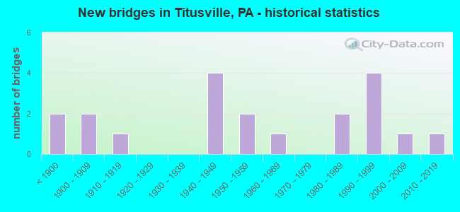
- New bridges - historical statistics
- 2Before 1900
- 21900-1909
- 11910-1919
- 41940-1949
- 21950-1959
- 11960-1969
- 21980-1989
- 41990-1999
- 12000-2009
- 12010-2019

- Reconstructed bridges - Historical Statistics
- 11960-1969
- 21970-1979
- 21980-1989
- 01990-1999
- 12000-2009


- Bridge Condition - Deck
- 22.2%Very good
- 22.2%Good
- 22.2%Satisfactory
- 22.2%Fair
- 5.6%Poor
- 5.6%Failed

- Bridge Condition - Superstructure
- 27.8%Very good
- 16.7%Good
- 11.1%Satisfactory
- 33.3%Fair
- 11.1%Imminent failure

- Bridge Condition - Substructure
- 5.6%Very good
- 38.9%Good
- 33.3%Satisfactory
- 11.1%Fair
- 11.1%Poor

- Bridge Condition - Channel
- 20.0%Very good
- 25.0%Good
- 35.0%Satisfactory
- 15.0%Fair
- 5.0%Poor
Find on map >> Show street view
Structure Number: 12908, Location: CITY OF TITUSVILLE (Lat: 41.622656, Lng: -79.673247), Route carried "on" structure: Business State highway 8, Year Built: 1940, Year Reconstructed: 1981, Status: Open, Structure Length: 5.64m (18.50ft), Average Daily Traffic: 4,371 (year 2020), Truck Traffic: 8%, Average Future Daily Traffic: 5,435 (year 2032), Design Load: H 20, Features Intersected: OVER OIL CREEK
Minimum Vertical Clearance: 5.41m (17.75ft), Kilometerpoint: 0.000, Lanes on structure: 2, Owner: State Highway Agency, Approaching Roadway Width: 9.1m (29.9ft), Material/Design: Steel, Design/Construction: Arch - Thru, Number Of Spans In Main Unit: 1, Length of Maximum Span: 54.9m (180.1ft), Curb or Sidewalk Widths: Left: 1.8m (5.9ft), Right: 1.8m (5.9ft), Curb-To-Curb Width: 9.3m (30.5ft), Out-to-Out Width: 10.7m (35.1ft)
Condition: Deck: Very good, Superstructure: Good, Substructure: Good, Channel: Very good, Operating Rating: 55.3 metric tons, Method Used To Determine Operating Rating: Load Testing, Inventory Rating: 35.4 metric tons, Method Used To Determine Inventory Rating: Load Testing, Structural Evaluation: Better than present minimum criteria, Deck Geometry: Meets minimum limits, Waterway Adequacy: Equal to present desirable criteria, Approach Roadway Alignment: Equal to present desirable criteria, Length Of Structure Improvement: 5.60m (18.37ft), Designated Inspection Frequency: Every 24 months, Critical Feature Inspection Frequency: Every 24 months, Inspection Date: April 2021, Critical Feature Inspection Date: April 2021, Bridge Improvement Cost: $31,000, Roadway Improvement Cost: $92,000, Total Project Cost: $422,000, Deck Structure Type: Concrete Cast-file-Place, Wearing Surface/Protective System: Wearing Surface: Monolithic Concrete, Deck Protection: Epoxy Coated Reinforcing
Find on map >> Show street view
Structure Number: 12959, Location: CITY OF TITUSVILLE (Lat: 41.627078, Lng: -79.686994), Route carried "on" structure: State highway 27, Year Built: 1949, Status: Open, Structure Length: 6.80m (22.31ft), Average Daily Traffic: 3,298 (year 2021), Truck Traffic: 8%, Average Future Daily Traffic: 5,453 (year 2032), Design Load: H 20, Features Intersected: OVER OIL CREEK
Minimum Vertical Clearance: 30+ m (98+ ft), Kilometerpoint: 33.658, Lanes on structure: 2, Owner: State Highway Agency, Approaching Roadway Width: 7.9m (25.9ft), Skew: 3 degrees, Material/Design: Steel, Design/Construction: Stringer/Multi-beam, Number Of Spans In Main Unit: 3, Length of Maximum Span: 21.9m (71.9ft), Curb or Sidewalk Widths: Left: 1.8m (5.9ft), Right: 0.2m (0.7ft), Curb-To-Curb Width: 7.9m (25.9ft), Out-to-Out Width: 10.4m (34.1ft)
Condition: Deck: Fair, Superstructure: Fair, Substructure: Fair, Channel: Satisfactory, Operating Rating: 59.9 metric tons, Method Used To Determine Operating Rating: Load Factor (LF), Inventory Rating: 36.3 metric tons, Method Used To Determine Inventory Rating: Load Factor (LF), Structural Evaluation: Somewhat better than minimum adequacy, Deck Geometry: High priority of corrective action, Waterway Adequacy: Equal to present minimum criteria, Approach Roadway Alignment: Equal to present desirable criteria, Length Of Structure Improvement: 7.80m (25.59ft), Designated Inspection Frequency: Every 24 months, Inspection Date: October 2019, Bridge Improvement Cost: $74,000, Roadway Improvement Cost: $217,000, Total Project Cost: $994,000, Deck Structure Type: Closed Grating, Wearing Surface/Protective System: Wearing Surface: Bituminous, Membrane: Preformed Fabric
Find on map >> Show street view
Structure Number: 12962, Location: OIL CREEK TOWNSHIP (Lat: 41.618808, Lng: -79.638689), Route carried "on" structure: State highway 27, Year Built: 1958, Status: Open, Structure Length: 4.48m (14.70ft), Average Daily Traffic: 4,961 (year 2022), Truck Traffic: 7%, Average Future Daily Traffic: 6,020 (year 2032), Design Load: HS 20, Features Intersected: OVER PINE CREEK
Minimum Vertical Clearance: 30+ m (98+ ft), Kilometerpoint: 36.947, Lanes on structure: 2, Owner: State Highway Agency, Approaching Roadway Width: 8.8m (28.9ft), Material/Design: Steel, Design/Construction: Stringer/Multi-beam, Number Of Spans In Main Unit: 2, Length of Maximum Span: 21.9m (71.9ft), Curb-To-Curb Width: 11.6m (38.1ft), Out-to-Out Width: 13.4m (44.0ft)
Condition: Deck: Satisfactory, Superstructure: Fair, Substructure: Satisfactory, Channel: Good, Operating Rating: 32.7 metric tons, Method Used To Determine Operating Rating: Load Factor (LF), Inventory Rating: 19.1 metric tons, Method Used To Determine Inventory Rating: Load Factor (LF), Structural Evaluation: Somewhat better than minimum adequacy, Deck Geometry: Somewhat better than minimum adequacy, Waterway Adequacy: Equal to present minimum criteria, Approach Roadway Alignment: Equal to present desirable criteria, Bridge Posting: Required (Relationship of Operating Rating to Maximum Legal Load: 10.0 - 19.9% below), Length Of Structure Improvement: 4.50m (14.76ft), Designated Inspection Frequency: Every 24 months, Inspection Date: July 2021, Bridge Improvement Cost: $7,000, Roadway Improvement Cost: $25,000, Total Project Cost: $96,000, Deck Structure Type: Concrete Cast-file-Place, Wearing Surface/Protective System: Wearing Surface: Bituminous, Membrane: Preformed Fabric
Find on map >> Show street view
Structure Number: 13031, Location: CITY OF TITUSVILLE (Lat: 41.632761, Lng: -79.674661), Route carried "on" structure: State highway 89, Year Built: 1903, Year Reconstructed: 1986, Status: Open, Structure Length: 0.76m (2.49ft), Average Daily Traffic: 2,692 (year 2022), Truck Traffic: 6%, Average Future Daily Traffic: 3,597 (year 2032), Design Load: H 15, Features Intersected: OVER CHURCH RUN
Minimum Vertical Clearance: 30+ m (98+ ft), Kilometerpoint: 0.678, Lanes on structure: 2, Owner: State Highway Agency, Approaching Roadway Width: 8.5m (27.9ft), Skew: 4 degrees, Material/Design: Concrete, Design/Construction: Slab, Number Of Spans In Main Unit: 1, Length of Maximum Span: 7.0m (23.0ft), Curb or Sidewalk Widths: Left: 0.0m, Right: 3.4m (11.2ft), Curb-To-Curb Width: 8.7m (28.5ft), Out-to-Out Width: 12.6m (41.3ft)
Condition: Deck: Good, Superstructure: Good, Substructure: Satisfactory, Channel: Satisfactory, Operating Rating: 50.8 metric tons, Method Used To Determine Operating Rating: Load Factor (LF), Inventory Rating: 30.8 metric tons, Method Used To Determine Inventory Rating: Load Factor (LF), Structural Evaluation: Equal to present minimum criteria, Deck Geometry: Meets minimum limits, Waterway Adequacy: Equal to present minimum criteria, Approach Roadway Alignment: Equal to present desirable criteria, Length Of Structure Improvement: 1.50m (4.92ft), Designated Inspection Frequency: Every 24 months, Inspection Date: March 2021, Wearing Surface/Protective System: Wearing Surface: Monolithic Concrete, Deck Protection: Epoxy Coated Reinforcing
Find on map >> Show street view
Structure Number: 13033, Location: OIL CREEK TOWNSHIP (Lat: 41.638794, Lng: -79.670517), Route carried "on" structure: State highway 89, Year Built: 1988, Status: Open, Structure Length: 0.79m (2.59ft), Average Daily Traffic: 887 (year 2020), Truck Traffic: 13%, Average Future Daily Traffic: 1,621 (year 2032), Design Load: HS 25 or greater, Features Intersected: OVER CHURCH RUN
Minimum Vertical Clearance: 30+ m (98+ ft), Kilometerpoint: 1.180, Lanes on structure: 2, Owner: State Highway Agency, Approaching Roadway Width: 7.0m (23.0ft), Skew: 3 degrees, Material/Design: Prestressed concrete, Design/Construction: Box Beam or Girders - Multiple, Number Of Spans In Main Unit: 1, Length of Maximum Span: 7.3m (24.0ft), Curb or Sidewalk Widths: Left: 0.2m (0.7ft), Right: 0.2m (0.7ft), Curb-To-Curb Width: 10.2m (33.5ft), Out-to-Out Width: 11.1m (36.4ft)
Condition: Deck: Good, Superstructure: Very good, Substructure: Very good, Channel: Satisfactory, Operating Rating: 89.8 metric tons, Method Used To Determine Operating Rating: Load Factor (LF), Inventory Rating: 58.1 metric tons, Method Used To Determine Inventory Rating: Load Factor (LF), Structural Evaluation: Equal to present desirable criteria, Deck Geometry: Equal to present minimum criteria, Waterway Adequacy: Equal to present minimum criteria, Approach Roadway Alignment: Better than present minimum criteria, Length Of Structure Improvement: 1.40m (4.59ft), Designated Inspection Frequency: Every 24 months, Inspection Date: June 2020, Deck Structure Type: Concrete Cast-file-Place, Wearing Surface/Protective System: Wearing Surface: Bituminous, Membrane: Preformed Fabric, Deck Protection: Epoxy Coated Reinforcing
Find on map >> Show street view
Structure Number: 13034, Location: OIL CREEK TOWNSHIP (Lat: 41.640600, Lng: -79.666300), Route carried "on" structure: State highway 89, Year Built: 1984, Status: Open, Structure Length: 0.76m (2.49ft), Average Daily Traffic: 887 (year 2020), Truck Traffic: 13%, Average Future Daily Traffic: 1,621 (year 2032), Design Load: HS 20, Features Intersected: OVER CHURCH RUN
Minimum Vertical Clearance: 30+ m (98+ ft), Kilometerpoint: 2.025, Lanes on structure: 2, Owner: State Highway Agency, Approaching Roadway Width: 6.7m (22.0ft), Skew: 2 degrees, Material/Design: Prestressed concrete, Design/Construction: Box Beam or Girders - Multiple, Number Of Spans In Main Unit: 1, Length of Maximum Span: 7.0m (23.0ft), Curb or Sidewalk Widths: Left: 0.2m (0.7ft), Right: 0.2m (0.7ft), Curb-To-Curb Width: 10.1m (33.1ft), Out-to-Out Width: 11.2m (36.7ft)
Condition: Deck: Fair, Superstructure: Fair, Substructure: Good, Channel: Good, Operating Rating: 88.0 metric tons, Method Used To Determine Operating Rating: Load Factor (LF), Inventory Rating: 39.9 metric tons, Method Used To Determine Inventory Rating: Load Factor (LF), Structural Evaluation: Somewhat better than minimum adequacy, Deck Geometry: Equal to present minimum criteria, Waterway Adequacy: Equal to present minimum criteria, Approach Roadway Alignment: Equal to present desirable criteria, Length Of Structure Improvement: 1.50m (4.92ft), Designated Inspection Frequency: Every 24 months, Inspection Date: June 2020, Deck Structure Type: Other, Wearing Surface/Protective System: Wearing Surface: Bituminous, Membrane: Preformed Fabric, Deck Protection: Epoxy Coated Reinforcing
Find on map >> Show street view
Structure Number: 13036, Location: OIL CREEK TOWNSHIP (Lat: 41.684306, Lng: -79.664869), Route carried "on" structure: State highway 89, Year Built: 1950, Status: Posted for load-capacity, Structure Length: 1.22m (4.00ft), Average Daily Traffic: 887 (year 2020), Truck Traffic: 13%, Average Future Daily Traffic: 1,621 (year 2032), Design Load: H 20, Features Intersected: OVER HUMMER CREEK
Minimum Vertical Clearance: 30+ m (98+ ft), Kilometerpoint: 6.705, Lanes on structure: 2, Owner: State Highway Agency, Approaching Roadway Width: 6.1m (20.0ft), Material/Design: Steel, Design/Construction: Stringer/Multi-beam, Number Of Spans In Main Unit: 1, Length of Maximum Span: 11.6m (38.1ft), Curb or Sidewalk Widths: Left: 0.2m (0.7ft), Right: 0.2m (0.7ft), Curb-To-Curb Width: 7.3m (24.0ft), Out-to-Out Width: 8.2m (26.9ft)
Condition: Deck: Fair, Superstructure: Fair, Substructure: Fair, Channel: Fair, Operating Rating: 45.4 metric tons, Method Used To Determine Operating Rating: Load Factor (LF), Inventory Rating: 27.2 metric tons, Method Used To Determine Inventory Rating: Load Factor (LF), Structural Evaluation: Somewhat better than minimum adequacy, Deck Geometry: Meets minimum limits, Waterway Adequacy: Equal to present minimum criteria, Approach Roadway Alignment: Equal to present minimum criteria, Length Of Structure Improvement: 1.20m (3.94ft), Designated Inspection Frequency: Every 24 months, Other Special Inspection Frequency: Every 12 months, Inspection Date: Febuary 2020, Other Special Inspection Date: Febuary 2021, Bridge Improvement Cost: $2,000, Roadway Improvement Cost: $11,000, Total Project Cost: $29,000, Deck Structure Type: Closed Grating, Wearing Surface/Protective System: Wearing Surface: Bituminous, Membrane: Preformed Fabric
Find on map >> Show street view
Structure Number: 1327, Location: OIL CREEK TOWNSHIP (Lat: 41.620061, Lng: -79.637325), Route carried "on" structure: State highway , Year Built: 1940, Year Reconstructed: 2013, Status: Open, Structure Length: 4.60m (15.09ft), Average Daily Traffic: 1,475 (year 2021), Truck Traffic: 11%, Average Future Daily Traffic: 2,656 (year 2032), Design Load: HL 93, Features Intersected: OVER PINE CREEK, Facility Carried by Structure: SR 2028,ENTERPRIZE
Minimum Vertical Clearance: 30+ m (98+ ft), Kilometerpoint: 0.000, Lanes on structure: 2, Owner: State Highway Agency, Approaching Roadway Width: 8.8m (28.9ft), Skew: 4 degrees, Material/Design: Prestressed concrete, Design/Construction: Box Beam or Girders - Single/Spread, Number Of Spans In Main Unit: 2, Length of Maximum Span: 22.6m (74.1ft), Curb-To-Curb Width: 8.5m (27.9ft), Out-to-Out Width: 9.5m (31.2ft)
Condition: Deck: Very good, Superstructure: Very good, Substructure: Good, Channel: Good, Operating Rating: 55.4 metric tons, Method Used To Determine Operating Rating: Assigned ratings based on Load and Resistance Factor Design (LRFD) reported by rating factor (RF) using HL93 loadings, Inventory Rating: 35.6 metric tons, Method Used To Determine Inventory Rating: Assigned ratings based on Load and Resistance Factor Design (LRFD) reported by rating factor (RF) using HL93 loadings, Structural Evaluation: Better than present minimum criteria, Deck Geometry: Somewhat better than minimum adequacy, Waterway Adequacy: Equal to present minimum criteria, Approach Roadway Alignment: Better than present minimum criteria, Length Of Structure Improvement: 4.80m (15.75ft), Designated Inspection Frequency: Every 24 months, Inspection Date: November 2021, Bridge Improvement Cost: $6,000, Roadway Improvement Cost: $18,000, Total Project Cost: $81,000, Deck Structure Type: Concrete Cast-file-Place, Wearing Surface/Protective System: Wearing Surface: Bituminous
Find on map >> Show street view
Structure Number: 13275, Location: OIL CREEK TOWNSHIP (Lat: 41.671647, Lng: -79.679964), Route carried "on" structure: State highway , Year Built: 1961, Year Reconstructed: 2021, Status: Open, Structure Length: 2.50m (8.20ft), Average Daily Traffic: 269 (year 2022), Truck Traffic: 5%, Average Future Daily Traffic: 488 (year 2032), Design Load: HS 20, Features Intersected: OVER THOMPSON RUN, Facility Carried by Structure: SR 2031,PERRY ST.
Minimum Vertical Clearance: 30+ m (98+ ft), Kilometerpoint: 4.117, Lanes on structure: 2, Owner: State Highway Agency, Approaching Roadway Width: 8.5m (27.9ft), Skew: 3 degrees, Material/Design: Concrete, Design/Construction: Box Beam or Girders - Single/Spread, Number Of Spans In Main Unit: 1, Length of Maximum Span: 24.7m (81.0ft), Curb or Sidewalk Widths: Left: 0.5m (1.6ft), Right: 0.5m (1.6ft), Curb-To-Curb Width: 8.5m (27.9ft), Out-to-Out Width: 10.2m (33.5ft)
Condition: Deck: Very good, Superstructure: Very good, Substructure: Good, Channel: Very good, Operating Rating: 60.8 metric tons, Method Used To Determine Operating Rating: Assigned ratings based on Load and Resistance Factor Design (LRFD) reported in metric tons, Inventory Rating: 39.0 metric tons, Method Used To Determine Inventory Rating: Assigned ratings based on Load and Resistance Factor Design (LRFD) reported in metric tons, Structural Evaluation: Better than present minimum criteria, Deck Geometry: Equal to present minimum criteria, Waterway Adequacy: Equal to present desirable criteria, Approach Roadway Alignment: Equal to present desirable criteria, Length Of Structure Improvement: 3.30m (10.83ft), Designated Inspection Frequency: Every 24 months, Inspection Date: November 2021, Deck Structure Type: Concrete Cast-file-Place, Wearing Surface/Protective System: Wearing Surface: Latex Concrete, Deck Protection: Epoxy Coated Reinforcing
Find on map >> Show street view
Structure Number: 13447, Location: 2.8 MI. E. OF TITUSVILLE (Lat: 41.633708, Lng: -79.620197), Route carried "on" structure: City street 7214, Year Built: 1945, Status: Open, Structure Length: 0.76m (2.49ft), Average Daily Traffic: 250 (year 2020), Truck Traffic: 1%, Average Future Daily Traffic: 350 (year 2040), Features Intersected: OVER HENDERSON RUN, Facility Carried by Structure: T-926,DOTYVILLE RD
Minimum Vertical Clearance: 30+ m (98+ ft), Kilometerpoint: 0.000, Lanes on structure: 2, Owner: Town or Township Highway Agency, Approaching Roadway Width: 3.7m (12.1ft), Skew: 3 degrees, Material/Design: Concrete continuous, Design/Construction: Stringer/Multi-beam, Number Of Spans In Main Unit: 1, Length of Maximum Span: 6.1m (20.0ft), Curb or Sidewalk Widths: Left: 0.2m (0.7ft), Right: 0.2m (0.7ft), Curb-To-Curb Width: 5.3m (17.4ft), Out-to-Out Width: 6.2m (20.3ft)
Condition: Deck: Fair, Superstructure: Fair, Substructure: Poor, Channel: Poor, Operating Rating: 49.0 metric tons, Method Used To Determine Operating Rating: Field evaluation and documented engineering judgment, Inventory Rating: 32.7 metric tons, Method Used To Determine Inventory Rating: Field evaluation and documented engineering judgment, Structural Evaluation: Meets minimum limits, Deck Geometry: High priority of replacement, Waterway Adequacy: Equal to present desirable criteria, Approach Roadway Alignment: Somewhat better than minimum adequacy, Length Of Structure Improvement: 0.90m (2.95ft), Designated Inspection Frequency: Every 24 months, Inspection Date: May 2020, Bridge Improvement Cost: $29,000, Roadway Improvement Cost: $185,000, Total Project Cost: $389,000, Deck Structure Type: Concrete Cast-file-Place, Wearing Surface/Protective System: Wearing Surface: Bituminous
Find on map >> Show street view
Structure Number: 13448, Location: 2 MI.E.TITUSVILLE ON T928 (Lat: 41.632378, Lng: -79.613472), Route carried "on" structure: City street 7214, Year Built: 1910, Year Reconstructed: 1983, Status: Posted for load, Structure Length: 1.58m (5.18ft), Average Daily Traffic: 250 (year 2020), Truck Traffic: 10%, Average Future Daily Traffic: 350 (year 2040), Design Load: HS 20, Features Intersected: OVER PINE CREEK, Facility Carried by Structure: T-928,DUNCAN ROAD
Minimum Vertical Clearance: 30+ m (98+ ft), Kilometerpoint: 0.000, Lanes on structure: 2, Owner: County Highway Agency, Approaching Roadway Width: 6.1m (20.0ft), Material/Design: Wood or Timber, Design/Construction: Stringer/Multi-beam, Number Of Spans In Main Unit: 1, Length of Maximum Span: 14.6m (47.9ft), Curb-To-Curb Width: 7.0m (23.0ft), Out-to-Out Width: 7.3m (24.0ft)
Condition: Deck: Satisfactory, Superstructure: Satisfactory, Substructure: Satisfactory, Channel: Satisfactory, Operating Rating: 29.9 metric tons, Method Used To Determine Operating Rating: Allowable Stress (AS), Inventory Rating: 21.8 metric tons, Method Used To Determine Inventory Rating: Allowable Stress (AS), Structural Evaluation: Equal to present minimum criteria, Deck Geometry: Meets minimum limits, Waterway Adequacy: Equal to present desirable criteria, Approach Roadway Alignment: Equal to present desirable criteria, Bridge Posting: Required (Relationship of Operating Rating to Maximum Legal Load: 20.0 - 29.9% below), Length Of Structure Improvement: 2.00m (6.56ft), Designated Inspection Frequency: Every 24 months, Other Special Inspection Frequency: Every 12 months, Inspection Date: April 2020, Other Special Inspection Date: April 2021, Bridge Improvement Cost: $48,000, Roadway Improvement Cost: $264,000, Total Project Cost: $648,000, Deck Structure Type: Wood or Timber, Wearing Surface/Protective System: Wearing Surface: Bituminous
Find on map >> Show street view
Structure Number: 1345, Location: 1MI EAST OF TITUSVILLE (Lat: 41.622122, Lng: -79.636153), Route carried "on" structure: State lands road 7214, Year Built: 1875, Year Reconstructed: 1960, Status: Closed, Structure Length: 3.14m (10.30ft), Average Daily Traffic: 50 (year 2010), Average Future Daily Traffic: 70 (year 2030), Features Intersected: OVER PINE CREEK, Facility Carried by Structure: T-993,MESSERALL RD
Minimum Vertical Clearance: 3.83m (12.57ft), Kilometerpoint: 0.000, Lanes on structure: 1, Owner: State Park, Forest, or Reservation Agency, Maintenance Responsibility: County Highway Agency, Approaching Roadway Width: 4.6m (15.1ft), Material/Design: Aluminum, Iron, Design/Construction: Truss - Thru, Number Of Spans In Main Unit: 1, Length of Maximum Span: 30.2m (99.1ft), Curb-To-Curb Width: 4.5m (14.8ft), Out-to-Out Width: 4.8m (15.7ft)
Condition: Deck: Failed, Superstructure: Imminent failure, Substructure: Satisfactory, Channel: Satisfactory, Waterway Adequacy: Equal to present minimum criteria, Approach Roadway Alignment: Meets minimum limits, Bridge Posting: Required (Relationship of Operating Rating to Maximum Legal Load: > 39.9% below), Length Of Structure Improvement: 3.90m (12.80ft), Designated Inspection Frequency: Every 24 months, Inspection Date: April 2020, Bridge Improvement Cost: $69,000, Roadway Improvement Cost: $264,000, Total Project Cost: $929,000, Deck Structure Type: Wood or Timber, Wearing Surface/Protective System: Wearing Surface: Bituminous
Find on map >> Show street view
Structure Number: 13541, Location: TITUSVILLE, BROWN STREET (Lat: 41.626350, Lng: -79.665314), Route carried "on" structure: City street 7302, Year Built: 1995, Status: Open, Structure Length: 0.61m (2.00ft), Average Daily Traffic: 50 (year 2020), Average Future Daily Traffic: 63 (year 2040), Design Load: HS 25 or greater, Features Intersected: OVER CHURCH RUN, Facility Carried by Structure: BROWN STREET
Minimum Vertical Clearance: 30+ m (98+ ft), Kilometerpoint: 0.000, Lanes on structure: 2, Owner: City or Municipal Highway Agency, Approaching Roadway Width: 8.5m (27.9ft), Skew: 2 degrees, Material/Design: Concrete, Design/Construction: Culvert, Number Of Spans In Main Unit: 1, Length of Maximum Span: 6.1m (20.0ft), Curb or Sidewalk Widths: Left: 0.0m, Right: 1.2m (3.9ft), Curb-To-Curb Width: 8.5m (27.9ft), Out-to-Out Width: 10.7m (35.1ft)
Condition: Channel: Fair, Culverts: Good, Operating Rating: 68.9 metric tons, Method Used To Determine Operating Rating: Load Factor (LF), Inventory Rating: 40.8 metric tons, Method Used To Determine Inventory Rating: Load Factor (LF), Structural Evaluation: Better than present minimum criteria, Deck Geometry: Better than present minimum criteria, Waterway Adequacy: Meets minimum limits, Approach Roadway Alignment: Equal to present desirable criteria, Length Of Structure Improvement: 1.20m (3.94ft), Designated Inspection Frequency: Every 24 months, Inspection Date: July 2020, Wearing Surface/Protective System: Wearing Surface: Bituminous, Deck Protection: Epoxy Coated Reinforcing
Find on map >> Show street view
Structure Number: 13542, Location: BROWN STREET,TITUSVILLE (Lat: 41.623817, Lng: -79.665347), Route carried "on" structure: City street 7302, Year Built: 1991, Status: Open, Structure Length: 5.52m (18.11ft), Average Daily Traffic: 500 (year 2020), Truck Traffic: 1%, Average Future Daily Traffic: 700 (year 2040), Design Load: HS 25 or greater, Features Intersected: OVER OIL CREEK, Facility Carried by Structure: BROWN STREET
Minimum Vertical Clearance: 30+ m (98+ ft), Kilometerpoint: 0.000, Lanes on structure: 2, Owner: County Highway Agency, Approaching Roadway Width: 8.5m (27.9ft), Material/Design: Prestressed concrete continuous, Design/Construction: Box Beam or Girders - Multiple, Number Of Spans In Main Unit: 2, Length of Maximum Span: 27.4m (89.9ft), Curb or Sidewalk Widths: Left: 0.2m (0.7ft), Right: 1.8m (5.9ft), Curb-To-Curb Width: 8.5m (27.9ft), Out-to-Out Width: 11.2m (36.7ft)
Condition: Deck: Satisfactory, Superstructure: Satisfactory, Substructure: Good, Channel: Good, Operating Rating: 90.7 metric tons, Method Used To Determine Operating Rating: Load Factor (LF), Inventory Rating: 23.6 metric tons, Method Used To Determine Inventory Rating: Load Factor (LF), Structural Evaluation: Equal to present minimum criteria, Deck Geometry: Somewhat better than minimum adequacy, Waterway Adequacy: Superior to present desirable criteria, Approach Roadway Alignment: Equal to present desirable criteria, Length Of Structure Improvement: 6.90m (22.64ft), Designated Inspection Frequency: Every 24 months, Inspection Date: August 2020, Deck Structure Type: Concrete Cast-file-Place, Wearing Surface/Protective System: Wearing Surface: Monolithic Concrete, Deck Protection: Epoxy Coated Reinforcing
Find on map >> Show street view
Structure Number: 13544, Location: DUTCH HILL RD.,TITUSVILLE (Lat: 41.617792, Lng: -79.671078), Route carried "on" structure: City street 7302, Year Built: 1992, Status: Open, Structure Length: 0.79m (2.59ft), Average Daily Traffic: 150 (year 2020), Truck Traffic: 1%, Average Future Daily Traffic: 188 (year 2040), Design Load: HS 25 or greater, Features Intersected: OVER HAMMOND RUN, Facility Carried by Structure: DUTCH HILL R.T-576
Minimum Vertical Clearance: 30+ m (98+ ft), Kilometerpoint: 0.000, Lanes on structure: 2, Owner: City or Municipal Highway Agency, Approaching Roadway Width: 6.1m (20.0ft), Skew: 1 degrees, Material/Design: Wood or Timber, Design/Construction: Slab, Number Of Spans In Main Unit: 1, Length of Maximum Span: 7.3m (24.0ft), Curb or Sidewalk Widths: Left: 0.1m (0.3ft), Right: 0.1m (0.3ft), Curb-To-Curb Width: 9.0m (29.5ft), Out-to-Out Width: 9.6m (31.5ft)
Condition: Deck: Good, Superstructure: Good, Substructure: Satisfactory, Channel: Fair, Operating Rating: 49.0 metric tons, Method Used To Determine Operating Rating: Field evaluation and documented engineering judgment, Inventory Rating: 32.7 metric tons, Method Used To Determine Inventory Rating: Field evaluation and documented engineering judgment, Structural Evaluation: Equal to present minimum criteria, Deck Geometry: Equal to present minimum criteria, Waterway Adequacy: Better than present minimum criteria, Approach Roadway Alignment: Equal to present desirable criteria, Length Of Structure Improvement: 1.00m (3.28ft), Designated Inspection Frequency: Every 24 months, Inspection Date: July 2020, Wearing Surface/Protective System: Wearing Surface: Bituminous
Find on map >> Show street view
Structure Number: 13546, Location: SOUTH PERRY ST,TITUSVILLE (Lat: 41.622800, Lng: -79.676944), Route carried "on" structure: City street 7302, Year Built: 1900, Year Reconstructed: 1994, Status: Closed, Structure Length: 3.96m (12.99ft), Average Daily Traffic: 5,000 (year 2017), Truck Traffic: 1%, Average Future Daily Traffic: 6,250 (year 2037), Features Intersected: OVER OIL CREEK, Facility Carried by Structure: SOUTH PERRY STREET
Minimum Vertical Clearance: 5.05m (16.57ft), Kilometerpoint: 0.000, Lanes on structure: 2, Owner: County Highway Agency, Approaching Roadway Width: 5.5m (18.0ft), Material/Design: Steel, Design/Construction: Truss - Thru, Number Of Spans In Main Unit: 1, Length of Maximum Span: 37.5m (123.0ft), Curb or Sidewalk Widths: Left: 0.0m, Right: 2.0m (6.6ft), Curb-To-Curb Width: 5.3m (17.4ft), Out-to-Out Width: 5.6m (18.4ft)
Condition: Deck: Poor, Superstructure: Imminent failure, Substructure: Poor, Channel: Good, Operating Rating: 20.0 metric tons, Method Used To Determine Operating Rating: Load Factor (LF), Inventory Rating: 10.0 metric tons, Method Used To Determine Inventory Rating: Load Factor (LF), Waterway Adequacy: Equal to present desirable criteria, Approach Roadway Alignment: Equal to present minimum criteria, Bridge Posting: Required (Relationship of Operating Rating to Maximum Legal Load: > 39.9% below), Length Of Structure Improvement: 5.00m (16.40ft), Designated Inspection Frequency: Every 24 months, Inspection Date: January 2020, Bridge Improvement Cost: $81,000, Roadway Improvement Cost: $264,000, Total Project Cost: $1,088,000, Deck Structure Type: Wood or Timber, Wearing Surface/Protective System: Wearing Surface: Bituminous, Membrane: Preformed Fabric
Find on map >> Show street view
Structure Number: 33905, Location: OIL CREEK TOWNSHIP (Lat: 41.565431, Lng: -79.656683), Route carried "on" structure: City street 7212, Year Built: 1888, Status: Posted for load, Structure Length: 4.69m (15.39ft), Average Daily Traffic: 100 (year 2015), Average Future Daily Traffic: 140 (year 2035), Design Load: H 10, Features Intersected: OVER OIL CREEK, Facility Carried by Structure: MILLER FARM ROAD
Minimum Vertical Clearance: 5.11m (16.77ft), Kilometerpoint: 0.000, Lanes on structure: 1, Owner: County Highway Agency, Approaching Roadway Width: 3.0m (9.8ft), Material/Design: Aluminum, Iron, Design/Construction: Truss - Thru, Number Of Spans In Main Unit: 1, Length of Maximum Span: 45.7m (149.9ft), Curb-To-Curb Width: 4.8m (15.7ft), Out-to-Out Width: 4.9m (16.1ft)
Condition: Deck: Satisfactory, Superstructure: Fair, Substructure: Satisfactory, Channel: Satisfactory, Operating Rating: 18.1 metric tons, Method Used To Determine Operating Rating: Load Factor (LF), Inventory Rating: 10.9 metric tons, Method Used To Determine Inventory Rating: Load Factor (LF), Structural Evaluation: Meets minimum limits, Deck Geometry: Equal to present desirable criteria, Waterway Adequacy: Equal to present desirable criteria, Approach Roadway Alignment: Meets minimum limits, Bridge Posting: Required (Relationship of Operating Rating to Maximum Legal Load: > 39.9% below), Length Of Structure Improvement: 5.90m (19.36ft), Designated Inspection Frequency: Every 24 months, Critical Feature Inspection Frequency: Every 12 months, Other Special Inspection Frequency: Every 12 months, Inspection Date: June 2020, Critical Feature Inspection Date: June 2021, Other Special Inspection Date: June 2021, Bridge Improvement Cost: $168,000, Roadway Improvement Cost: $488,000, Total Project Cost: $2,354,000, Deck Structure Type: Wood or Timber
Find on map >> Show street view
Structure Number: 40417, Location: ON DRAKE WELL PARK ROAD (Lat: 41.615136, Lng: -79.657039), Route carried "on" structure: State highway , Year Built: 1999, Status: Open, Structure Length: 4.27m (14.01ft), Average Daily Traffic: 202 (year 2022), Truck Traffic: 3%, Average Future Daily Traffic: 1,032 (year 2032), Design Load: HS 25 or greater, Features Intersected: OVER OIL CREEK, Facility Carried by Structure: SR 1011,DRAKE WELL
Minimum Vertical Clearance: 5.41m (17.75ft), Kilometerpoint: 0.000, Lanes on structure: 2, Owner: State Highway Agency, Approaching Roadway Width: 10.1m (33.1ft), Material/Design: Steel, Design/Construction: Stringer/Multi-beam, Number Of Spans In Main Unit: 1, Length of Maximum Span: 41.1m (134.8ft), Curb or Sidewalk Widths: Left: 0.0m, Right: 1.8m (5.9ft), Curb-To-Curb Width: 3.5m (11.5ft), Out-to-Out Width: 4.3m (14.1ft)
Condition: Deck: Very good, Superstructure: Very good, Substructure: Good, Channel: Very good, Operating Rating: 80.7 metric tons, Method Used To Determine Operating Rating: Load Factor (LF), Inventory Rating: 48.1 metric tons, Method Used To Determine Inventory Rating: Load Factor (LF), Structural Evaluation: Better than present minimum criteria, Deck Geometry: High priority of replacement, Waterway Adequacy: Superior to present desirable criteria, Approach Roadway Alignment: Meets minimum limits, Length Of Structure Improvement: 5.20m (17.06ft), Designated Inspection Frequency: Every 48 months, Inspection Date: June 2019, Deck Structure Type: Concrete Cast-file-Place, Wearing Surface/Protective System: Wearing Surface: Monolithic Concrete, Deck Protection: Epoxy Coated Reinforcing
Find on map >> Show street view
Structure Number: 41643, Location: TITUSVILLE,WALNUT STREET (Lat: 41.629542, Lng: -79.671294), Route carried "on" structure: City street 7302, Year Built: 2002, Status: Open, Structure Length: 0.73m (2.40ft), Average Daily Traffic: 50 (year 2020), Average Future Daily Traffic: 70 (year 2040), Design Load: HS 25 or greater, Features Intersected: OVER CHURCH RUN, Facility Carried by Structure: WALNUT STREET
Minimum Vertical Clearance: 30+ m (98+ ft), Kilometerpoint: 0.000, Lanes on structure: 2, Owner: City or Municipal Highway Agency, Approaching Roadway Width: 9.1m (29.9ft), Skew: 4 degrees, Material/Design: Concrete, Design/Construction: Culvert, Number Of Spans In Main Unit: 1, Length of Maximum Span: 7.3m (24.0ft), Curb or Sidewalk Widths: Left: 1.8m (5.9ft), Right: 1.5m (4.9ft), Curb-To-Curb Width: 9.1m (29.9ft), Out-to-Out Width: 18.9m (62.0ft)
Condition: Channel: Satisfactory, Culverts: Good, Operating Rating: 91.6 metric tons, Method Used To Determine Operating Rating: Load Factor (LF), Inventory Rating: 54.4 metric tons, Method Used To Determine Inventory Rating: Load Factor (LF), Structural Evaluation: Better than present minimum criteria, Deck Geometry: Better than present minimum criteria, Waterway Adequacy: Meets minimum limits, Approach Roadway Alignment: Equal to present desirable criteria, Length Of Structure Improvement: 1.40m (4.59ft), Designated Inspection Frequency: Every 24 months, Inspection Date: July 2020, Wearing Surface/Protective System: Wearing Surface: Bituminous, Membrane: Preformed Fabric, Deck Protection: Epoxy Coated Reinforcing
Find on map >> Show street view
Structure Number: 46773, Location: OIL CREEK TWP (Lat: 41.682689, Lng: -79.667078), Route carried "on" structure: State highway , Year Built: 2011, Status: Open, Structure Length: 2.56m (8.40ft), Average Daily Traffic: 369 (year 2022), Truck Traffic: 5%, Average Future Daily Traffic: 472 (year 2032), Design Load: HL 93, Features Intersected: OVER SHIRLEY RUN, Facility Carried by Structure: SR 1013, Thompson
Minimum Vertical Clearance: 30+ m (98+ ft), Kilometerpoint: 5.761, Lanes on structure: 2, Owner: State Highway Agency, Approaching Roadway Width: 7.9m (25.9ft), Material/Design: Prestressed concrete, Design/Construction: Box Beam or Girders - Single/Spread, Number Of Spans In Main Unit: 1, Length of Maximum Span: 24.4m (80.1ft), Curb or Sidewalk Widths: Left: 0.2m (0.7ft), Right: 0.2m (0.7ft), Curb-To-Curb Width: 7.9m (25.9ft), Out-to-Out Width: 9.0m (29.5ft)
Condition: Deck: Good, Superstructure: Very good, Substructure: Good, Channel: Very good, Operating Rating: 62.9 metric tons, Method Used To Determine Operating Rating: Assigned ratings based on Load and Resistance Factor Design (LRFD) reported by rating factor (RF) using HL93 loadings, Inventory Rating: 32.7 metric tons, Method Used To Determine Inventory Rating: Assigned ratings based on Load and Resistance Factor Design (LRFD) reported by rating factor (RF) using HL93 loadings, Structural Evaluation: Better than present minimum criteria, Deck Geometry: Somewhat better than minimum adequacy, Waterway Adequacy: Superior to present desirable criteria, Approach Roadway Alignment: Meets minimum limits, Designated Inspection Frequency: Every 24 months, Inspection Date: November 2021, Deck Structure Type: Concrete Cast-file-Place, Wearing Surface/Protective System: Wearing Surface: Monolithic Concrete, Deck Protection: Epoxy Coated Reinforcing