Bridge Statistics for Tobaccoville, North Carolina (NC)
Condition, Traffic, Stress, Structural Evaluation, Project Costs
- National Bridge Inventory (NBI) Statistics
- 23Number of bridges
- 272ft / 83.0mTotal length
- 191,340Total average daily traffic
- 21,767Total average daily truck traffic
- National Bridge Inventory (NBI) Registered Bridges for Tobaccoville
- No street view available for this location
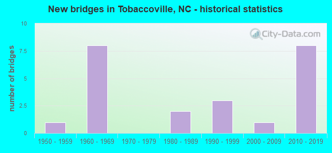
- New bridges - historical statistics
- 11950-1959
- 81960-1969
- 21980-1989
- 31990-1999
- 12000-2009
- 82010-2019


- Bridge Condition - Deck
- 25.0%Very good
- 41.7%Good
- 8.3%Satisfactory
- 16.7%Fair
- 8.3%Poor

- Bridge Condition - Superstructure
- 25.0%Very good
- 25.0%Good
- 16.7%Satisfactory
- 25.0%Fair
- 8.3%Serious

- Bridge Condition - Substructure
- 33.3%Very good
- 16.7%Good
- 16.7%Satisfactory
- 33.3%Fair

- Bridge Condition - Channel
- 7.1%Excellent
- 50.0%Good
- 28.6%Satisfactory
- 14.3%Fair
Find on map >> Show street view
Structure Number: 670002, Location: 0.8 MI. S. JCT. NC67 (Lat: 36.199744, Lng: -80.416919), Route carried "on" structure: State highway 1470, Year Built: 2013, Status: Open, Structure Length: 2.19m (7.19ft), Average Daily Traffic: 340 (year 2017), Truck Traffic: 7%, Average Future Daily Traffic: 680 (year 2040), Design Load: HL 93, Features Intersected: FRIES CREEK
Minimum Vertical Clearance: 30+ m (98+ ft), Kilometerpoint: 0.000, Lanes on structure: 2, Owner: State Highway Agency, Approaching Roadway Width: 5.7m (18.7ft), Skew: 1 degrees, Material/Design: Prestressed concrete, Design/Construction: Slab, Number Of Spans In Main Unit: 1, Length of Maximum Span: 20.7m (67.9ft), Curb-To-Curb Width: 8.3m (27.2ft), Out-to-Out Width: 9.1m (29.9ft)
Condition: Deck: Good, Superstructure: Good, Substructure: Very good, Channel: Good, Operating Rating: 57.1 metric tons, Method Used To Determine Operating Rating: Load and Resistance Factor (LRFR), Inventory Rating: 42.6 metric tons, Method Used To Determine Inventory Rating: Load and Resistance Factor (LRFR), Structural Evaluation: Better than present minimum criteria, Deck Geometry: Somewhat better than minimum adequacy, Waterway Adequacy: Better than present minimum criteria, Approach Roadway Alignment: Equal to present desirable criteria, Designated Inspection Frequency: Every 24 months, Inspection Date: July 2021, Deck Structure Type: Concrete Precast Panels, Wearing Surface/Protective System: Wearing Surface: Bituminous
Find on map >> Show street view
Structure Number: 670013, Location: 0.3 MI. N. JCT. NC67 (Lat: 36.220175, Lng: -80.429206), Route carried "on" structure: State highway 1600, Year Built: 1980, Status: Open, Structure Length: 2.80m (9.19ft), Average Daily Traffic: 2,000 (year 2017), Truck Traffic: 7%, Average Future Daily Traffic: 4,000 (year 2040), Features Intersected: OLD RICHMOND CREEK
Minimum Vertical Clearance: 30+ m (98+ ft), Kilometerpoint: 0.000, Lanes on structure: 2, Owner: State Highway Agency, Approaching Roadway Width: 7.6m (24.9ft), Material/Design: Steel, Design/Construction: Stringer/Multi-beam, Number Of Spans In Main Unit: 3, Length of Maximum Span: 9.1m (29.9ft), Curb-To-Curb Width: 10.4m (34.1ft), Out-to-Out Width: 10.7m (35.1ft)
Condition: Deck: Good, Superstructure: Satisfactory, Substructure: Fair, Channel: Fair, Operating Rating: 79.8 metric tons, Method Used To Determine Operating Rating: Load Factor (LF), Inventory Rating: 48.0 metric tons, Method Used To Determine Inventory Rating: Load Factor (LF), Structural Evaluation: Somewhat better than minimum adequacy, Deck Geometry: Equal to present minimum criteria, Waterway Adequacy: Somewhat better than minimum adequacy, Approach Roadway Alignment: Equal to present desirable criteria, Designated Inspection Frequency: Every 24 months, Inspection Date: August 2021, Deck Structure Type: Corrugated Steel, Wearing Surface/Protective System: Wearing Surface: Bituminous
Find on map >> Show street view
Structure Number: 670014, Location: 0.1 MI. S. JCT. SR1602 (Lat: 36.232639, Lng: -80.436436), Route carried "on" structure: State highway 1600, Year Built: 1980, Status: Open, Structure Length: 0.67m (2.20ft), Average Daily Traffic: 1,900 (year 2015), Truck Traffic: 7%, Average Future Daily Traffic: 3,800 (year 2040), Design Load: HS 20+Mod, Features Intersected: UT TO YADKIN RIVER
Minimum Vertical Clearance: 30+ m (98+ ft), Kilometerpoint: 0.000, Lanes on structure: 2, Owner: State Highway Agency, Approaching Roadway Width: 7.3m (24.0ft), Skew: 4 degrees, Material/Design: Steel, Design/Construction: Culvert, Number Of Spans In Main Unit: 2, Length of Maximum Span: 2.1m (6.9ft)
Condition: Channel: Satisfactory, Culverts: Satisfactory, Operating Rating: 89.8 metric tons, Method Used To Determine Operating Rating: Load and Resistance Factor (LRFR), Inventory Rating: 89.8 metric tons, Method Used To Determine Inventory Rating: Load and Resistance Factor (LRFR), Structural Evaluation: Equal to present minimum criteria, Waterway Adequacy: Better than present minimum criteria, Approach Roadway Alignment: Equal to present desirable criteria, Designated Inspection Frequency: Every 24 months, Inspection Date: July 2021
Find on map >> Show street view
Structure Number: 670015, Location: 0.8 MI. W. JCT. SR1600 (Lat: 36.255989, Lng: -80.442686), Route carried "on" structure: State highway 1604, Year Built: 2014, Status: Open, Structure Length: 5.42m (17.78ft), Average Daily Traffic: 2,200 (year 2013), Truck Traffic: 6%, Average Future Daily Traffic: 4,400 (year 2040), Design Load: HL 93, Features Intersected: LITTLE YADKIN RIVER
Minimum Vertical Clearance: 30+ m (98+ ft), Kilometerpoint: 0.000, Lanes on structure: 2, Owner: State Highway Agency, Approaching Roadway Width: 6.0m (19.7ft), Material/Design: Prestressed concrete, Design/Construction: Slab, Number Of Spans In Main Unit: 3, Length of Maximum Span: 21.0m (68.9ft), Curb or Sidewalk Widths: Left: 0.1m (0.3ft), Right: 0.1m (0.3ft), Curb-To-Curb Width: 8.1m (26.6ft), Out-to-Out Width: 9.1m (29.9ft)
Condition: Deck: Very good, Superstructure: Very good, Substructure: Very good, Channel: Excellent, Operating Rating: 56.2 metric tons, Method Used To Determine Operating Rating: Load and Resistance Factor (LRFR), Inventory Rating: 41.7 metric tons, Method Used To Determine Inventory Rating: Load and Resistance Factor (LRFR), Structural Evaluation: Equal to present desirable criteria, Deck Geometry: High priority of corrective action, Waterway Adequacy: Superior to present desirable criteria, Approach Roadway Alignment: Equal to present desirable criteria, Designated Inspection Frequency: Every 24 months, Inspection Date: May 2020, Deck Structure Type: Concrete Precast Panels, Wearing Surface/Protective System: Wearing Surface: Bituminous
Find on map >> Show street view
Structure Number: 670145, Location: 1.0 MI. E. JCT. NC67 (Lat: 36.202936, Lng: -80.368572), Route carried "on" structure: State highway 1625, Year Built: 2014, Status: Open, Structure Length: 2.19m (7.19ft), Average Daily Traffic: 440 (year 2013), Truck Traffic: 7%, Average Future Daily Traffic: 880 (year 2040), Design Load: HL 93, Features Intersected: MILL CREEK
Minimum Vertical Clearance: 30+ m (98+ ft), Kilometerpoint: 0.000, Lanes on structure: 2, Owner: State Highway Agency, Approaching Roadway Width: 6.0m (19.7ft), Skew: 1 degrees, Material/Design: Prestressed concrete, Design/Construction: Slab, Number Of Spans In Main Unit: 1, Length of Maximum Span: 21.0m (68.9ft), Curb-To-Curb Width: 8.2m (26.9ft), Out-to-Out Width: 9.1m (29.9ft)
Condition: Deck: Very good, Superstructure: Very good, Substructure: Very good, Channel: Satisfactory, Operating Rating: 57.1 metric tons, Method Used To Determine Operating Rating: Load and Resistance Factor (LRFR), Inventory Rating: 42.6 metric tons, Method Used To Determine Inventory Rating: Load and Resistance Factor (LRFR), Structural Evaluation: Equal to present desirable criteria, Deck Geometry: Somewhat better than minimum adequacy, Waterway Adequacy: Better than present minimum criteria, Approach Roadway Alignment: Equal to present desirable criteria, Designated Inspection Frequency: Every 24 months, Inspection Date: May 2020, Deck Structure Type: Concrete Precast Panels, Wearing Surface/Protective System: Wearing Surface: Bituminous
Find on map >> Show street view
Structure Number: 67016, Location: 0.1 MI. E. JCT. SR1637 (Lat: 36.225436, Lng: -80.338494), Route carried "on" structure: State highway 1898, Year Built: 1992, Status: Open, Structure Length: 2.80m (9.19ft), Average Daily Traffic: 850 (year 2019), Truck Traffic: 7%, Average Future Daily Traffic: 1,700 (year 2040), Design Load: HS 20+Mod, Features Intersected: MUDDY CREEK
Minimum Vertical Clearance: 30+ m (98+ ft), Kilometerpoint: 0.000, Lanes on structure: 2, Owner: State Highway Agency, Approaching Roadway Width: 7.0m (23.0ft), Material/Design: Prestressed concrete, Design/Construction: Slab, Number Of Spans In Main Unit: 3, Length of Maximum Span: 8.8m (28.9ft), Curb-To-Curb Width: 7.3m (24.0ft), Out-to-Out Width: 8.2m (26.9ft)
Condition: Deck: Good, Superstructure: Satisfactory, Substructure: Satisfactory, Channel: Good, Operating Rating: 89.8 metric tons, Method Used To Determine Operating Rating: Load Factor (LF), Inventory Rating: 75.2 metric tons, Method Used To Determine Inventory Rating: Load Factor (LF), Structural Evaluation: Equal to present minimum criteria, Deck Geometry: Meets minimum limits, Waterway Adequacy: Better than present minimum criteria, Approach Roadway Alignment: Equal to present desirable criteria, Designated Inspection Frequency: Every 24 months, Inspection Date: August 2021, Deck Structure Type: Concrete Precast Panels, Wearing Surface/Protective System: Wearing Surface: Bituminous
Find on map >> Show street view
Structure Number: 67018, Location: 0.9 MI. N. JCT. NC65 (Lat: 36.213728, Lng: -80.317856), Route carried "on" structure: State highway 1632, Year Built: 2000, Status: Open, Structure Length: 0.85m (2.79ft), Average Daily Traffic: 550 (year 2015), Truck Traffic: 7%, Average Future Daily Traffic: 1,100 (year 2040), Design Load: HS 20+Mod, Features Intersected: BEAVER DAM CREEK
Minimum Vertical Clearance: 30+ m (98+ ft), Kilometerpoint: 0.000, Lanes on structure: 2, Owner: State Highway Agency, Approaching Roadway Width: 7.0m (23.0ft), Material/Design: Steel, Design/Construction: Culvert, Number Of Spans In Main Unit: 2, Length of Maximum Span: 3.6m (11.8ft)
Condition: Channel: Good, Culverts: Satisfactory, Operating Rating: 89.8 metric tons, Method Used To Determine Operating Rating: Load and Resistance Factor (LRFR), Inventory Rating: 89.8 metric tons, Method Used To Determine Inventory Rating: Load and Resistance Factor (LRFR), Structural Evaluation: Equal to present minimum criteria, Waterway Adequacy: Equal to present minimum criteria, Approach Roadway Alignment: Equal to present desirable criteria, Designated Inspection Frequency: Every 24 months, Inspection Date: August 2021
Find on map >> Show street view
Structure Number: 670225, Location: 0.7 MI. N. JCT. SR1604 (Lat: 36.259425, Lng: -80.407022), Route carried "on" structure: State highway 1607, Year Built: 1996, Status: Open, Structure Length: 1.34m (4.40ft), Average Daily Traffic: 380 (year 2000), Truck Traffic: 6%, Average Future Daily Traffic: 760 (year 2040), Design Load: HS 20+Mod, Features Intersected: CROOKED RUN CREEK
Minimum Vertical Clearance: 30+ m (98+ ft), Kilometerpoint: 0.000, Lanes on structure: 2, Owner: State Highway Agency, Approaching Roadway Width: 6.0m (19.7ft), Material/Design: Steel, Design/Construction: Culvert, Number Of Spans In Main Unit: 3, Length of Maximum Span: 3.6m (11.8ft)
Condition: Channel: Good, Culverts: Satisfactory, Operating Rating: 89.8 metric tons, Method Used To Determine Operating Rating: Load and Resistance Factor (LRFR), Inventory Rating: 89.8 metric tons, Method Used To Determine Inventory Rating: Load and Resistance Factor (LRFR), Structural Evaluation: Equal to present minimum criteria, Waterway Adequacy: Equal to present minimum criteria, Approach Roadway Alignment: Equal to present desirable criteria, Designated Inspection Frequency: Every 24 months, Inspection Date: August 2021
Find on map >> Show street view
Structure Number: 670315, Location: 0.2 MI. E. JCT. SR1898 (Lat: 36.228636, Lng: -80.323761), Route carried "on" structure: State highway 1632, Year Built: 1962, Status: Open, Structure Length: 7.10m (23.29ft), Average Daily Traffic: 4,100 (year 2013), Truck Traffic: 7%, Average Future Daily Traffic: 8,200 (year 2040), Design Load: H 15, Features Intersected: US52
Minimum Vertical Clearance: 30+ m (98+ ft), Kilometerpoint: 0.000, Lanes on structure: 2, Lanes under structure: 4, Owner: State Highway Agency, Approaching Roadway Width: 7.3m (24.0ft), Skew: 2 degrees, Material/Design: Prestressed concrete, Design/Construction: Stringer/Multi-beam, Number Of Spans In Main Unit: 4, Length of Maximum Span: 17.9m (58.7ft), Curb or Sidewalk Widths: Left: 0.3m (1.0ft), Right: 0.3m (1.0ft), Curb-To-Curb Width: 7.3m (24.0ft), Out-to-Out Width: 8.6m (28.2ft)
Condition: Deck: Fair, Superstructure: Fair, Substructure: Fair, Operating Rating: 68.9 metric tons, Method Used To Determine Operating Rating: Load Factor (LF), Inventory Rating: 34.4 metric tons, Method Used To Determine Inventory Rating: Load Factor (LF), Structural Evaluation: Somewhat better than minimum adequacy, Deck Geometry: High priority of replacement, Underclear: High priority of corrective action, Approach Roadway Alignment: Equal to present desirable criteria, Designated Inspection Frequency: Every 24 months, Inspection Date: July 2020, Deck Structure Type: Concrete Cast-file-Place, Wearing Surface/Protective System: Wearing Surface: Monolithic Concrete
Find on map >> Show street view
Structure Number: 670318, Location: 0.9 MI. S. JCT. SR1620 (Lat: 36.232644, Lng: -80.331472), Route carried "on" structure: US 52, Year Built: 1961, Status: Open, Structure Length: 1.31m (4.30ft), Average Daily Traffic: 42,000 (year 2013), Truck Traffic: 12%, Average Future Daily Traffic: 84,000 (year 2040), Design Load: HS 20+Mod, Features Intersected: MUDDY CREEK
Minimum Vertical Clearance: 30+ m (98+ ft), Kilometerpoint: 36.728, Lanes on structure: 4, Base Highway Network: Yes (Inventory Route: 2, Subroute: 52), Owner: State Highway Agency, Approaching Roadway Width: 23.1m (75.8ft), Skew: 33 degrees, Material/Design: Concrete continuous, Design/Construction: Culvert, Number Of Spans In Main Unit: 3, Length of Maximum Span: 3.6m (11.8ft)
Condition: Channel: Good, Culverts: Satisfactory, Operating Rating: 41.7 metric tons, Method Used To Determine Operating Rating: Field evaluation and documented engineering judgment, Inventory Rating: 32.6 metric tons, Method Used To Determine Inventory Rating: Field evaluation and documented engineering judgment, Structural Evaluation: Equal to present minimum criteria, Waterway Adequacy: Better than present minimum criteria, Approach Roadway Alignment: Equal to present desirable criteria, Designated Inspection Frequency: Every 24 months, Inspection Date: July 2020
Find on map >> Show street view
Structure Number: 670319, Location: 1.5 MI. N. JCT. SR1632 (Lat: 36.240733, Lng: -80.344950), Route carried "on" structure: US 52, Year Built: 2014, Status: Open, Structure Length: 3.44m (11.29ft), Average Daily Traffic: 21,000 (year 2013), Truck Traffic: 12%, Average Future Daily Traffic: 42,000 (year 2040), Design Load: HL 93, Features Intersected: SR1620
Minimum Vertical Clearance: 30+ m (98+ ft), Kilometerpoint: 37.003, Lanes on structure: 2, Lanes under structure: 2, Base Highway Network: Yes (Inventory Route: 2, Subroute: 52), Owner: State Highway Agency, Approaching Roadway Width: 12.1m (39.7ft), Skew: 13 degrees, Material/Design: Steel, Design/Construction: Stringer/Multi-beam, Number Of Spans In Main Unit: 1, Length of Maximum Span: 32.9m (107.9ft), Curb-To-Curb Width: 12.8m (42.0ft), Out-to-Out Width: 13.7m (44.9ft)
Condition: Deck: Good, Superstructure: Good, Substructure: Good, Operating Rating: 67.1 metric tons, Method Used To Determine Operating Rating: Load and Resistance Factor (LRFR), Inventory Rating: 51.7 metric tons, Method Used To Determine Inventory Rating: Load and Resistance Factor (LRFR), Structural Evaluation: Better than present minimum criteria, Deck Geometry: Equal to present desirable criteria, Underclear: Equal to present minimum criteria, Approach Roadway Alignment: Equal to present desirable criteria, Designated Inspection Frequency: Every 24 months, Inspection Date: May 2020, Deck Structure Type: Concrete Cast-file-Place, Wearing Surface/Protective System: Wearing Surface: Monolithic Concrete
Find on map >> Show street view
Structure Number: 670335, Location: 1.5 MI. N. JCT. SR1632 (Lat: 36.240697, Lng: -80.345200), Route carried "on" structure: US 52, Year Built: 2014, Status: Open, Structure Length: 3.44m (11.29ft), Average Daily Traffic: 21,000 (year 2013), Truck Traffic: 12%, Average Future Daily Traffic: 54,700 (year 2040), Design Load: HL 93, Features Intersected: SR1620
Minimum Vertical Clearance: 30+ m (98+ ft), Kilometerpoint: 37.003, Lanes on structure: 2, Lanes under structure: 2, Base Highway Network: Yes (Inventory Route: 2, Subroute: 52), Owner: State Highway Agency, Approaching Roadway Width: 11.8m (38.7ft), Skew: 13 degrees, Material/Design: Steel, Design/Construction: Stringer/Multi-beam, Number Of Spans In Main Unit: 1, Length of Maximum Span: 32.6m (107.0ft), Curb-To-Curb Width: 12.8m (42.0ft), Out-to-Out Width: 13.7m (44.9ft)
Condition: Deck: Good, Superstructure: Good, Substructure: Good, Operating Rating: 67.1 metric tons, Method Used To Determine Operating Rating: Load and Resistance Factor (LRFR), Inventory Rating: 51.7 metric tons, Method Used To Determine Inventory Rating: Load and Resistance Factor (LRFR), Structural Evaluation: Better than present minimum criteria, Deck Geometry: Equal to present desirable criteria, Underclear: Equal to present minimum criteria, Approach Roadway Alignment: Equal to present desirable criteria, Designated Inspection Frequency: Every 24 months, Inspection Date: August 2020, Deck Structure Type: Concrete Cast-file-Place, Wearing Surface/Protective System: Wearing Surface: Monolithic Concrete, Deck Protection: Epoxy Coated Reinforcing
Find on map >> Show street view
Structure Number: 670343, Location: 0.3 MI. S. JCT. SR1634 (Lat: 36.244703, Lng: -80.349247), Route carried "on" structure: US 52, Year Built: 1962, Year Reconstructed: 1996, Status: Open, Structure Length: 5.09m (16.70ft), Average Daily Traffic: 19,500 (year 2013), Truck Traffic: 12%, Average Future Daily Traffic: 39,000 (year 2040), Design Load: HS 20+Mod, Features Intersected: SOUTHERN RAILWAY
Minimum Vertical Clearance: 30+ m (98+ ft), Kilometerpoint: 37.100, Lanes on structure: 2, Base Highway Network: Yes (Inventory Route: 2, Subroute: 52), Owner: State Highway Agency, Approaching Roadway Width: 8.5m (27.9ft), Skew: 10 degrees, Material/Design: Prestressed concrete, Design/Construction: Stringer/Multi-beam, Number Of Spans In Main Unit: 3, Length of Maximum Span: 16.4m (53.8ft), Curb-To-Curb Width: 8.6m (28.2ft), Out-to-Out Width: 10.2m (33.5ft)
Condition: Deck: Fair, Superstructure: Fair, Substructure: Satisfactory, Operating Rating: 89.8 metric tons, Method Used To Determine Operating Rating: Load Factor (LF), Inventory Rating: 51.7 metric tons, Method Used To Determine Inventory Rating: Load Factor (LF), Structural Evaluation: Somewhat better than minimum adequacy, Deck Geometry: High priority of replacement, Underclear: Equal to present minimum criteria, Approach Roadway Alignment: Equal to present desirable criteria, Designated Inspection Frequency: Every 24 months, Inspection Date: July 2020, Deck Structure Type: Concrete Cast-file-Place, Wearing Surface/Protective System: Wearing Surface: Latex Concrete
Find on map >> Show street view
Structure Number: 670344, Location: 0.3 MI. S. JCT. SR1634 (Lat: 36.244597, Lng: -80.349433), Route carried "on" structure: US 52, Year Built: 1962, Year Reconstructed: 1996, Status: Open, Structure Length: 5.09m (16.70ft), Average Daily Traffic: 19,500 (year 2013), Truck Traffic: 12%, Average Future Daily Traffic: 39,000 (year 2040), Design Load: HS 20+Mod, Features Intersected: SOUTHERN RAILWAY
Minimum Vertical Clearance: 30+ m (98+ ft), Kilometerpoint: 37.103, Lanes on structure: 3, Base Highway Network: Yes (Inventory Route: 2, Subroute: 52), Owner: State Highway Agency, Approaching Roadway Width: 13.1m (43.0ft), Skew: 10 degrees, Material/Design: Prestressed concrete, Design/Construction: Stringer/Multi-beam, Number Of Spans In Main Unit: 3, Length of Maximum Span: 16.4m (53.8ft), Curb-To-Curb Width: 13.5m (44.3ft), Out-to-Out Width: 14.5m (47.6ft)
Condition: Deck: Satisfactory, Superstructure: Fair, Substructure: Fair, Operating Rating: 86.1 metric tons, Method Used To Determine Operating Rating: Load Factor (LF), Inventory Rating: 35.3 metric tons, Method Used To Determine Inventory Rating: Load Factor (LF), Structural Evaluation: Somewhat better than minimum adequacy, Deck Geometry: High priority of replacement, Underclear: Equal to present minimum criteria, Approach Roadway Alignment: Equal to present desirable criteria, Designated Inspection Frequency: Every 24 months, Inspection Date: July 2020, Deck Structure Type: Concrete Cast-file-Place, Wearing Surface/Protective System: Wearing Surface: Latex Concrete
Find on map >> Show street view
Structure Number: 670407, Location: 0.1 MI. W. JCT. SR1637 (Lat: 36.225500, Lng: -80.341183), Route carried "on" structure: State highway 1898, Year Built: 1965, Status: Open, Structure Length: 1.06m (3.48ft), Average Daily Traffic: 850 (year 2019), Truck Traffic: 7%, Average Future Daily Traffic: 1,700 (year 2040), Design Load: HS 20+Mod, Features Intersected: UT TO MUDDY CREEK
Minimum Vertical Clearance: 30+ m (98+ ft), Kilometerpoint: 0.000, Lanes on structure: 2, Owner: State Highway Agency, Approaching Roadway Width: 7.3m (24.0ft), Material/Design: Steel, Design/Construction: Culvert, Number Of Spans In Main Unit: 2, Length of Maximum Span: 4.8m (15.7ft)
Condition: Channel: Satisfactory, Culverts: Satisfactory, Operating Rating: 89.8 metric tons, Method Used To Determine Operating Rating: Load and Resistance Factor (LRFR), Inventory Rating: 89.8 metric tons, Method Used To Determine Inventory Rating: Load and Resistance Factor (LRFR), Structural Evaluation: Equal to present minimum criteria, Waterway Adequacy: Equal to present minimum criteria, Approach Roadway Alignment: Equal to present desirable criteria, Designated Inspection Frequency: Every 24 months, Inspection Date: August 2021
Find on map >> Show street view
Structure Number: 670554, Location: 0.1 MI. E. JCT. SR1638 (Lat: 36.238378, Lng: -80.325800), Route carried "on" structure: State highway 1620, Year Built: 1962, Status: Open, Structure Length: 0.64m (2.10ft), Average Daily Traffic: 2,400 (year 2015), Truck Traffic: 7%, Average Future Daily Traffic: 4,800 (year 2040), Design Load: HS 20+Mod, Features Intersected: MUDDY CREEK
Minimum Vertical Clearance: 30+ m (98+ ft), Kilometerpoint: 0.000, Lanes on structure: 2, Owner: State Highway Agency, Approaching Roadway Width: 7.0m (23.0ft), Material/Design: Concrete continuous, Design/Construction: Culvert, Number Of Spans In Main Unit: 2, Length of Maximum Span: 3.0m (9.8ft)
Condition: Channel: Fair, Culverts: Satisfactory, Operating Rating: 41.7 metric tons, Method Used To Determine Operating Rating: Field evaluation and documented engineering judgment, Inventory Rating: 32.6 metric tons, Method Used To Determine Inventory Rating: Field evaluation and documented engineering judgment, Structural Evaluation: Equal to present minimum criteria, Waterway Adequacy: Equal to present minimum criteria, Approach Roadway Alignment: Equal to present desirable criteria, Designated Inspection Frequency: Every 24 months, Inspection Date: August 2021
Find on map >> Show street view
Structure Number: 1690002, Location: 1.6 MI.S.JCT.SR1102 (Lat: 36.265653, Lng: -80.430089), Route carried "on" structure: State highway 1103, Year Built: 2013, Status: Open, Structure Length: 3.26m (10.70ft), Average Daily Traffic: 500 (year 2015), Truck Traffic: 6%, Average Future Daily Traffic: 1,000 (year 2040), Design Load: HL 93, Features Intersected: CROOKED RUN CREEK
Minimum Vertical Clearance: 30+ m (98+ ft), Kilometerpoint: 0.000, Lanes on structure: 2, Owner: State Highway Agency, Approaching Roadway Width: 7.0m (23.0ft), Material/Design: Prestressed concrete, Design/Construction: Slab, Number Of Spans In Main Unit: 2, Length of Maximum Span: 21.3m (69.9ft), Curb-To-Curb Width: 8.2m (26.9ft), Out-to-Out Width: 9.1m (29.9ft)
Condition: Deck: Very good, Superstructure: Very good, Substructure: Very good, Channel: Good, Operating Rating: 49.8 metric tons, Method Used To Determine Operating Rating: Load and Resistance Factor (LRFR), Inventory Rating: 38.1 metric tons, Method Used To Determine Inventory Rating: Load and Resistance Factor (LRFR), Structural Evaluation: Equal to present desirable criteria, Deck Geometry: Somewhat better than minimum adequacy, Waterway Adequacy: Equal to present desirable criteria, Approach Roadway Alignment: High priority of corrective action, Designated Inspection Frequency: Every 24 months, Inspection Date: June 2021, Deck Structure Type: Concrete Precast Panels, Wearing Surface/Protective System: Wearing Surface: Bituminous
Find on map >> Show street view
Structure Number: 1690003, Location: 0.8 MI. E. JCT. SR1104 (Lat: 36.261825, Lng: -80.417239), Route carried "on" structure: State highway 1105, Year Built: 1995, Status: Open, Structure Length: 1.28m (4.20ft), Average Daily Traffic: 830 (year 2012), Truck Traffic: 6%, Average Future Daily Traffic: 1,660 (year 2040), Design Load: HS 20+Mod, Features Intersected: CROOKED RUN CREEK
Minimum Vertical Clearance: 30+ m (98+ ft), Kilometerpoint: 0.000, Lanes on structure: 2, Owner: State Highway Agency, Approaching Roadway Width: 7.3m (24.0ft), Skew: 1 degrees, Material/Design: Steel, Design/Construction: Culvert, Number Of Spans In Main Unit: 3, Length of Maximum Span: 3.6m (11.8ft)
Condition: Channel: Good, Culverts: Satisfactory, Operating Rating: 89.8 metric tons, Method Used To Determine Operating Rating: Load and Resistance Factor (LRFR), Inventory Rating: 89.8 metric tons, Method Used To Determine Inventory Rating: Load and Resistance Factor (LRFR), Structural Evaluation: Equal to present minimum criteria, Waterway Adequacy: Better than present minimum criteria, Approach Roadway Alignment: Equal to present minimum criteria, Designated Inspection Frequency: Every 24 months, Inspection Date: March 2021
Find on map >> Show street view
Structure Number: 1970035, Location: .1 MI.E.JCT.SR1607 (Lat: 36.216167, Lng: -80.432264), Route carried "on" structure: State highway 67, Year Built: 1950, Status: Temporarily open, Structure Length: 33.04m (108.40ft), Average Daily Traffic: 4,700 (year 2019), Truck Traffic: 8%, Average Future Daily Traffic: 9,400 (year 2040), Design Load: HS 15, Features Intersected: YADKIN RIVER
Minimum Vertical Clearance: 30+ m (98+ ft), Kilometerpoint: 0.000, Lanes on structure: 2, Owner: State Highway Agency, Approaching Roadway Width: 8.5m (27.9ft), Material/Design: Steel continuous, Design/Construction: Stringer/Multi-beam, Number Of Spans In Main Unit: 15, Length of Maximum Span: 21.9m (71.9ft), Curb or Sidewalk Widths: Left: 0.6m (2.0ft), Right: 0.6m (2.0ft), Curb-To-Curb Width: 7.9m (25.9ft), Out-to-Out Width: 9.8m (32.2ft)
Condition: Deck: Poor, Superstructure: Serious, Substructure: Fair, Channel: Satisfactory, Operating Rating: 44.4 metric tons, Method Used To Determine Operating Rating: Load Factor (LF), Inventory Rating: 26.3 metric tons, Method Used To Determine Inventory Rating: Load Factor (LF), Structural Evaluation: High priority of corrective action, Deck Geometry: High priority of corrective action, Waterway Adequacy: Better than present minimum criteria, Approach Roadway Alignment: Equal to present desirable criteria, Designated Inspection Frequency: Every 24 months, Underwater Inspection Frequency: Every 60 months, Inspection Date: June 2021, Underwater Inspection Date: April 2020, Deck Structure Type: Concrete Cast-file-Place, Wearing Surface/Protective System: Wearing Surface: Monolithic Concrete
Find on map >> Show street view
Structure Number: 670315, Location: 0.2 MI. E. JCT. SR1898 (Lat: 36.228636, Lng: -80.323761), Route carried "under" structure: US 52, Year Built: 1962, Structure Length: 0. m, Average Daily Traffic: 22,000 (year 2013), Truck Traffic: 12%, Features Intersected: SR1632
Minimum Vertical Clearance: 4.61m (15.12ft), Kilometerpoint: 36.545, Lanes on structure: 2, Lanes under structure: 2, Material/Design: Prestressed concrete, Design/Construction: Stringer/Multi-beam, Length of Maximum Span: 17.9m (58.7ft)
Find on map >> Show street view
Structure Number: 670315, Location: 0.2 MI. E. JCT. SR1898 (Lat: 36.228636, Lng: -80.323761), Route carried "under" structure: US 52, Year Built: 1962, Structure Length: 0. m, Average Daily Traffic: 22,000 (year 2013), Truck Traffic: 12%, Features Intersected: SR1632
Minimum Vertical Clearance: 4.95m (16.24ft), Kilometerpoint: 36.545, Lanes on structure: 2, Lanes under structure: 2, Material/Design: Prestressed concrete, Design/Construction: Stringer/Multi-beam, Length of Maximum Span: 17.9m (58.7ft)
Find on map >> Show street view
Structure Number: 670319, Location: 1.5 MI. N. JCT. SR1632 (Lat: 36.240733, Lng: -80.344950), Route carried "under" structure: State highway 1620, Year Built: 2014, Structure Length: 0. m, Average Daily Traffic: 500 (year 2013), Truck Traffic: 11%, Features Intersected: US52 NBL
Minimum Vertical Clearance: 5.25m (17.22ft), Kilometerpoint: 0.000, Lanes on structure: 2, Lanes under structure: 2, Material/Design: Steel, Design/Construction: Stringer/Multi-beam, Length of Maximum Span: 32.9m (107.9ft)
Find on map >> Show street view
Structure Number: 670335, Location: 1.5 MI. N. JCT. SR1632 (Lat: 36.240697, Lng: -80.345200), Route carried "under" structure: State highway 1620, Year Built: 2014, Structure Length: 0. m, Average Daily Traffic: 1,800 (year 2013), Truck Traffic: 7%, Features Intersected: US52 SBL
Minimum Vertical Clearance: 4.67m (15.32ft), Kilometerpoint: 0.000, Lanes on structure: 2, Lanes under structure: 2, Material/Design: Steel, Design/Construction: Stringer/Multi-beam, Length of Maximum Span: 32.6m (107.0ft)