Bridge Statistics for Tompkins, New York (NY)
Condition, Traffic, Stress, Structural Evaluation, Project Costs
- National Bridge Inventory (NBI) Statistics
- 19Number of bridges
- 305ft / 93.2mTotal length
- $33,156,000Total costs
- 4,634Total average daily traffic
- 623Total average daily truck traffic
- 5,597Total future (year 2014) average daily traffic
- National Bridge Inventory (NBI) Registered Bridges for Tompkins
- No street view available for this location
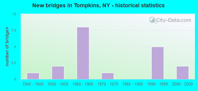
- New bridges - historical statistics
- 11940-1949
- 21950-1959
- 81960-1969
- 11970-1979
- 51990-1999
- 22000-2009


- Bridge Condition - Deck
- 8.3%Excellent
- 8.3%Very good
- 25.0%Good
- 50.0%Satisfactory
- 8.3%Fair

- Bridge Condition - Superstructure
- 16.7%Excellent
- 41.7%Very good
- 16.7%Good
- 8.3%Satisfactory
- 16.7%Fair

- Bridge Condition - Substructure
- 8.3%Excellent
- 8.3%Very good
- 50.0%Good
- 16.7%Satisfactory
- 16.7%Fair

- Bridge Condition - Channel
- 5.3%Excellent
- 10.5%Very good
- 21.1%Good
- 42.1%Satisfactory
- 15.8%Fair
- 5.3%Poor

- Bridge Condition - Culverts
- 71.4%Good
- 28.6%Satisfactory
Find on map >> Show street view
Structure Number: 100767, Location: JCTRTE10+CANNONSVILLE RES (Lat: 42.088039, Lng: -75.313814), Route carried "on" structure: State highway 10, Year Built: 1962, Year Reconstructed: 2000, Status: Open, Structure Length: 36.85m (120.90ft), Average Daily Traffic: 365 (year 2016), Truck Traffic: 26%, Average Future Daily Traffic: 380 (year 2040), Design Load: HS 25 or greater, Features Intersected: Cannonsville Resv
Minimum Vertical Clearance: 30+ m (98+ ft), Kilometerpoint: 14.207, Lanes on structure: 2, Base Highway Network: Yes, Owner: Local Agency, Maintenance Responsibility: State Highway Agency, Approaching Roadway Width: 9.1m (29.9ft), Skew: 2 degrees, Material/Design: Steel continuous, Design/Construction: Stringer/Multi-beam, Number Of Spans In Main Unit: 7, Length of Maximum Span: 68.6m (225.1ft), Curb-To-Curb Width: 9.0m (29.5ft), Out-to-Out Width: 9.6m (31.5ft)
Condition: Deck: Satisfactory, Superstructure: Very good, Substructure: Good, Channel: Very good, Operating Rating: 52.6 metric tons, Method Used To Determine Operating Rating: Load Factor (LF), Inventory Rating: 30.8 metric tons, Method Used To Determine Inventory Rating: Load Factor (LF), Structural Evaluation: Better than present minimum criteria, Deck Geometry: Equal to present minimum criteria, Waterway Adequacy: Equal to present desirable criteria, Approach Roadway Alignment: Equal to present desirable criteria, Length Of Structure Improvement: 36.85m (120.90ft), Designated Inspection Frequency: Every 24 months, Underwater Inspection Frequency: Every 60 months, Inspection Date: April 2020, Underwater Inspection Date: November 2018, Bridge Improvement Cost: $7,327,000, Roadway Improvement Cost: $4,291,000, Total Project Cost: $11,617,000 ( Estimate for 2021), Deck Structure Type: Concrete Cast-file-Place, Wearing Surface/Protective System: Wearing Surface: Integral Concrete, Deck Protection: Epoxy Coated Reinforcing
Find on map >> Show street view
Structure Number: 100768, Location: 2.2 MI NW JCT SH 10 & 990 (Lat: 42.110289, Lng: -75.258694), Route carried "on" structure: State highway 10, Year Built: 1961, Status: Open, Structure Length: 0.88m (2.89ft), Average Daily Traffic: 365 (year 2016), Truck Traffic: 26%, Average Future Daily Traffic: 380 (year 2040), Design Load: HS 20, Features Intersected: DRYDEN CREEK
Minimum Vertical Clearance: 30+ m (98+ ft), Kilometerpoint: 21.754, Lanes on structure: 2, Base Highway Network: Yes, Owner: Local Agency, Maintenance Responsibility: State Highway Agency, Approaching Roadway Width: 11.9m (39.0ft), Material/Design: Concrete, Design/Construction: Culvert, Number Of Spans In Main Unit: 3, Length of Maximum Span: 2.4m (7.9ft)
Condition: Channel: Satisfactory, Culverts: Satisfactory, Operating Rating: 74.1 metric tons, Method Used To Determine Operating Rating: Field evaluation and documented engineering judgment, Inventory Rating: 29.4 metric tons, Method Used To Determine Inventory Rating: Field evaluation and documented engineering judgment, Structural Evaluation: Equal to present minimum criteria, Waterway Adequacy: Equal to present minimum criteria, Approach Roadway Alignment: Equal to present desirable criteria, Length Of Structure Improvement: 0.88m (2.89ft), Designated Inspection Frequency: Every 24 months, Underwater Inspection Frequency: Every 60 months, Inspection Date: July 2021, Underwater Inspection Date: August 2016, Bridge Improvement Cost: $186,000, Roadway Improvement Cost: $109,000, Total Project Cost: $295,000 ( Estimate for 2021)
Find on map >> Show street view
Structure Number: 104042, Location: IN TROUT CREEK - SH 206 (Lat: 42.204564, Lng: -75.277403), Route carried "on" structure: State highway 206, Year Built: 1998, Status: Open, Structure Length: 0.70m (2.30ft), Average Daily Traffic: 1,595 (year 2020), Truck Traffic: 12%, Average Future Daily Traffic: 1,604 (year 2040), Design Load: HS 25 or greater, Features Intersected: TROUT CREEK
Minimum Vertical Clearance: 30+ m (98+ ft), Kilometerpoint: 13.355, Lanes on structure: 2, Base Highway Network: Yes, Owner: State Highway Agency, Approaching Roadway Width: 11.6m (38.1ft), Skew: 1 degrees, Material/Design: Concrete, Design/Construction: Frame, Number Of Spans In Main Unit: 1, Length of Maximum Span: 6.7m (22.0ft), Curb-To-Curb Width: 11.6m (38.1ft), Out-to-Out Width: 12.6m (41.3ft)
Condition: Deck: Good, Superstructure: Good, Substructure: Good, Channel: Satisfactory, Operating Rating: 92.5 metric tons, Method Used To Determine Operating Rating: Load Factor (LF), Inventory Rating: 55.3 metric tons, Method Used To Determine Inventory Rating: Load Factor (LF), Structural Evaluation: Better than present minimum criteria, Deck Geometry: Equal to present minimum criteria, Waterway Adequacy: Meets minimum limits, Approach Roadway Alignment: Equal to present desirable criteria, Length Of Structure Improvement: 0.70m (2.30ft), Designated Inspection Frequency: Every 24 months, Inspection Date: August 2020, Bridge Improvement Cost: $240,000, Roadway Improvement Cost: $140,000, Total Project Cost: $380,000 ( Estimate for 2021), Wearing Surface/Protective System: Wearing Surface: Bituminous
Find on map >> Show street view
Structure Number: 105057, Location: 4 MI S JCT SH 10 & SH 268 (Lat: 42.042078, Lng: -75.251081), Route carried "on" structure: State highway 268, Year Built: 1953, Status: Open, Structure Length: 0.79m (2.59ft), Average Daily Traffic: 430 (year 2017), Truck Traffic: 13%, Average Future Daily Traffic: 602 (year 2037), Features Intersected: CADOSIA CREEK
Minimum Vertical Clearance: 30+ m (98+ ft), Kilometerpoint: 10.957, Lanes on structure: 2, Base Highway Network: Yes, Owner: State Highway Agency, Approaching Roadway Width: 7.6m (24.9ft), Skew: 3 degrees, Material/Design: Concrete, Design/Construction: Slab, Number Of Spans In Main Unit: 1, Length of Maximum Span: 7.3m (24.0ft), Curb-To-Curb Width: 9.4m (30.8ft), Out-to-Out Width: 10.1m (33.1ft)
Condition: Deck: Satisfactory, Superstructure: Fair, Substructure: Fair, Channel: Good, Operating Rating: 56.2 metric tons, Method Used To Determine Operating Rating: Load Factor (LF), Inventory Rating: 33.6 metric tons, Method Used To Determine Inventory Rating: Load Factor (LF), Structural Evaluation: Somewhat better than minimum adequacy, Deck Geometry: Equal to present minimum criteria, Waterway Adequacy: Meets minimum limits, Approach Roadway Alignment: Equal to present desirable criteria, Length Of Structure Improvement: 0.79m (2.59ft), Designated Inspection Frequency: Every 24 months, Inspection Date: July 2020, Bridge Improvement Cost: $369,000, Roadway Improvement Cost: $216,000, Total Project Cost: $586,000 ( Estimate for 2021), Wearing Surface/Protective System: Wearing Surface: Bituminous
Find on map >> Show street view
Structure Number: 105058, Location: JCT RT 268 & W BR DEL RIV (Lat: 42.093375, Lng: -75.238508), Route carried "on" structure: State highway 268, Year Built: 1962, Year Reconstructed: 2000, Status: Open, Structure Length: 18.41m (60.40ft), Average Daily Traffic: 430 (year 2017), Truck Traffic: 13%, Average Future Daily Traffic: 602 (year 2037), Design Load: HS 25 or greater, Features Intersected: CANNONSVILLE RES
Minimum Vertical Clearance: 30+ m (98+ ft), Kilometerpoint: 16.911, Lanes on structure: 2, Base Highway Network: Yes, Owner: Local Agency, Maintenance Responsibility: State Highway Agency, Approaching Roadway Width: 9.1m (29.9ft), Material/Design: Steel continuous, Design/Construction: Stringer/Multi-beam, Number Of Spans In Main Unit: 4, Length of Maximum Span: 45.7m (149.9ft), Curb-To-Curb Width: 9.0m (29.5ft), Out-to-Out Width: 9.6m (31.5ft)
Condition: Deck: Satisfactory, Superstructure: Very good, Substructure: Good, Channel: Very good, Operating Rating: 79.8 metric tons, Method Used To Determine Operating Rating: Load Factor (LF), Inventory Rating: 48.1 metric tons, Method Used To Determine Inventory Rating: Load Factor (LF), Structural Evaluation: Better than present minimum criteria, Deck Geometry: Somewhat better than minimum adequacy, Waterway Adequacy: Equal to present minimum criteria, Approach Roadway Alignment: Equal to present desirable criteria, Length Of Structure Improvement: 18.40m (60.37ft), Designated Inspection Frequency: Every 24 months, Underwater Inspection Frequency: Every 60 months, Inspection Date: September 2021, Underwater Inspection Date: November 2018, Bridge Improvement Cost: $3,809,000, Roadway Improvement Cost: $2,230,000, Total Project Cost: $6,039,000 ( Estimate for 2021), Deck Structure Type: Concrete Cast-file-Place, Wearing Surface/Protective System: Wearing Surface: Integral Concrete, Deck Protection: Epoxy Coated Reinforcing
Find on map >> Show street view
Structure Number: 107892, Location: 4 MI S Jct SH 10 & 268 (Lat: 42.023742, Lng: -75.253583), Route carried "on" structure: State highway 268, Year Built: 2007, Status: Open, Structure Length: 0.67m (2.20ft), Average Daily Traffic: 430 (year 2017), Truck Traffic: 13%, Average Future Daily Traffic: 602 (year 2037), Design Load: HS 25 or greater, Features Intersected: CADOSIA CREEK
Minimum Vertical Clearance: 30+ m (98+ ft), Kilometerpoint: 8.850, Lanes on structure: 2, Base Highway Network: Yes, Owner: State Highway Agency, Approaching Roadway Width: 11.9m (39.0ft), Skew: 3 degrees, Material/Design: Concrete, Design/Construction: Culvert, Number Of Spans In Main Unit: 1, Length of Maximum Span: 6.4m (21.0ft), Curb-To-Curb Width: 11.9m (39.0ft), Out-to-Out Width: 19.2m (63.0ft)
Condition: Channel: Good, Culverts: Good, Operating Rating: 83.5 metric tons, Method Used To Determine Operating Rating: Load Factor (LF), Inventory Rating: 49.9 metric tons, Method Used To Determine Inventory Rating: Load Factor (LF), Structural Evaluation: Better than present minimum criteria, Deck Geometry: Better than present minimum criteria, Waterway Adequacy: Equal to present desirable criteria, Approach Roadway Alignment: Equal to present desirable criteria, Length Of Structure Improvement: 0.67m (2.20ft), Designated Inspection Frequency: Every 24 months, Inspection Date: September 2020, Bridge Improvement Cost: $228,000, Roadway Improvement Cost: $133,000, Total Project Cost: $361,000 ( Estimate for 2021), Wearing Surface/Protective System: Wearing Surface: Bituminous
Find on map >> Show street view
Structure Number: 222646, Location: 5 MILES N OF CANNONSVILLE (Lat: 42.128986, Lng: -75.299764), Route carried "on" structure: Other road , Year Built: 1963, Year Reconstructed: 2008, Status: Open, Structure Length: 22.86m (75.00ft), Truck Traffic: 5%, Design Load: HS 25 or greater, Features Intersected: CANNONSVILLE RESV, Facility Carried by Structure: TROUT CREEK ROAD
Minimum Vertical Clearance: 30+ m (98+ ft), Kilometerpoint: 4.827, Lanes on structure: 2, Owner: Local Agency, Approaching Roadway Width: 8.5m (27.9ft), Material/Design: Steel continuous, Design/Construction: Stringer/Multi-beam, Number Of Spans In Main Unit: 5, Length of Maximum Span: 45.7m (149.9ft), Curb-To-Curb Width: 10.4m (34.1ft), Out-to-Out Width: 10.8m (35.4ft)
Condition: Deck: Good, Superstructure: Excellent, Substructure: Satisfactory, Channel: Excellent, Operating Rating: 94.3 metric tons, Method Used To Determine Operating Rating: Allowable Stress (AS), Inventory Rating: 52.6 metric tons, Method Used To Determine Inventory Rating: Allowable Stress (AS), Structural Evaluation: Equal to present minimum criteria, Deck Geometry: Superior to present desirable criteria, Waterway Adequacy: Equal to present minimum criteria, Approach Roadway Alignment: Better than present minimum criteria, Length Of Structure Improvement: 22.86m (75.00ft), Designated Inspection Frequency: Every 24 months, Underwater Inspection Frequency: Every 60 months, Inspection Date: July 2020, Underwater Inspection Date: November 2018, Bridge Improvement Cost: $5,150,000, Roadway Improvement Cost: $3,016,000, Total Project Cost: $8,167,000 ( Estimate for 2021), Deck Structure Type: Concrete Cast-file-Place, Wearing Surface/Protective System: Wearing Surface: Integral Concrete, Deck Protection: Epoxy Coated Reinforcing
Find on map >> Show street view
Structure Number: 222647, Location: 3.5 MI S OF TROUT CREEK (Lat: 42.156956, Lng: -75.291567), Route carried "on" structure: Other road , Year Built: 1963, Status: Open, Structure Length: 0.70m (2.30ft), Truck Traffic: 5%, Design Load: H 20, Features Intersected: MORMON HOLLOW BRK, Facility Carried by Structure: TROUT CREEK ROAD
Minimum Vertical Clearance: 30+ m (98+ ft), Kilometerpoint: 8.174, Lanes on structure: 2, Owner: Local Agency, Approaching Roadway Width: 9.8m (32.2ft), Material/Design: Concrete, Design/Construction: Culvert, Number Of Spans In Main Unit: 1, Length of Maximum Span: 6.4m (21.0ft)
Condition: Channel: Satisfactory, Culverts: Good, Structural Evaluation: Better than present minimum criteria, Waterway Adequacy: Meets minimum limits, Approach Roadway Alignment: Equal to present desirable criteria, Length Of Structure Improvement: 0.70m (2.30ft), Designated Inspection Frequency: Every 24 months, Inspection Date: August 2021, Bridge Improvement Cost: $289,000, Roadway Improvement Cost: $169,000, Total Project Cost: $459,000 ( Estimate for 2021)
Find on map >> Show street view
Structure Number: 222648, Location: 3 MILES S OF TROUT CREEK (Lat: 42.161025, Lng: -75.284900), Route carried "on" structure: Other road , Year Built: 1963, Status: Open, Structure Length: 1.31m (4.30ft), Average Daily Traffic: 88 (year 2016), Truck Traffic: 8%, Average Future Daily Traffic: 123 (year 2036), Design Load: H 20, Features Intersected: TROUT CREEK, Facility Carried by Structure: COUNTY RD 47
Minimum Vertical Clearance: 30+ m (98+ ft), Kilometerpoint: 0.048, Lanes on structure: 2, Owner: Local Agency, Approaching Roadway Width: 9.8m (32.2ft), Material/Design: Concrete continuous, Design/Construction: Culvert, Number Of Spans In Main Unit: 2, Length of Maximum Span: 6.4m (21.0ft)
Condition: Channel: Good, Culverts: Good, Structural Evaluation: Better than present minimum criteria, Waterway Adequacy: Somewhat better than minimum adequacy, Approach Roadway Alignment: Equal to present desirable criteria, Length Of Structure Improvement: 1.31m (4.30ft), Designated Inspection Frequency: Every 24 months, Inspection Date: August 2021, Bridge Improvement Cost: $395,000, Roadway Improvement Cost: $231,000, Total Project Cost: $626,000 ( Estimate for 2021)
Find on map >> Show street view
Structure Number: 222649, Location: 5.8 MI S TROUT CREEK (Lat: 42.131258, Lng: -75.310328), Route carried "on" structure: Other road , Year Built: 1963, Status: Open, Structure Length: 0.82m (2.69ft), Average Daily Traffic: 1 (year 2016), Truck Traffic: 5%, Average Future Daily Traffic: 1 (year 2036), Design Load: H 20, Features Intersected: DRY BROOK, Facility Carried by Structure: DRY BROOK ROAD
Minimum Vertical Clearance: 30+ m (98+ ft), Kilometerpoint: 1.400, Lanes on structure: 2, Owner: Local Agency, Approaching Roadway Width: 8.2m (26.9ft), Skew: 3 degrees, Material/Design: Concrete, Design/Construction: Culvert, Number Of Spans In Main Unit: 1, Length of Maximum Span: 6.4m (21.0ft)
Condition: Channel: Satisfactory, Culverts: Good, Structural Evaluation: Better than present minimum criteria, Waterway Adequacy: Meets minimum limits, Approach Roadway Alignment: Equal to present desirable criteria, Length Of Structure Improvement: 0.82m (2.69ft), Designated Inspection Frequency: Every 24 months, Inspection Date: August 2021, Bridge Improvement Cost: $325,000, Roadway Improvement Cost: $190,000, Total Project Cost: $515,000 ( Estimate for 2021)
Find on map >> Show street view
Structure Number: 22265, Location: 7 MILES SW OF LOOMIS (Lat: 42.117222, Lng: -75.250181), Route carried "on" structure: Other road , Year Built: 1962, Status: Open, Structure Length: 1.25m (4.10ft), Average Daily Traffic: 41 (year 2016), Truck Traffic: 5%, Average Future Daily Traffic: 57 (year 2036), Design Load: H 20, Features Intersected: DRYDEN CREEK, Facility Carried by Structure: DRYDEN CREEK ROAD
Minimum Vertical Clearance: 30+ m (98+ ft), Kilometerpoint: 5.181, Lanes on structure: 2, Owner: Local Agency, Approaching Roadway Width: 8.2m (26.9ft), Skew: 3 degrees, Material/Design: Concrete continuous, Design/Construction: Culvert, Number Of Spans In Main Unit: 2, Length of Maximum Span: 5.1m (16.7ft)
Condition: Channel: Fair, Culverts: Good, Inventory Rating: 84.4 metric tons, Method Used To Determine Inventory Rating: Load Factor (LF), Structural Evaluation: Better than present minimum criteria, Waterway Adequacy: Meets minimum limits, Approach Roadway Alignment: Equal to present desirable criteria, Length Of Structure Improvement: 1.24m (4.07ft), Designated Inspection Frequency: Every 24 months, Inspection Date: August 2021, Bridge Improvement Cost: $366,000, Roadway Improvement Cost: $215,000, Total Project Cost: $581,000 ( Estimate for 2021)
Find on map >> Show street view
Structure Number: 22272, Location: 4.5 MI SW OF LOOMIS (Lat: 42.163456, Lng: -75.266733), Route carried "on" structure: Other road , Year Built: 1997, Status: Open, Structure Length: 1.22m (4.00ft), Average Daily Traffic: 5 (year 2017), Truck Traffic: 5%, Average Future Daily Traffic: 7 (year 2037), Design Load: HS 25 or greater, Features Intersected: LOOMIS BROOK, Facility Carried by Structure: LEWIS ROAD
Minimum Vertical Clearance: 30+ m (98+ ft), Kilometerpoint: 0.032, Lanes on structure: 1, Owner: County Highway Agency, Approaching Roadway Width: 4.3m (14.1ft), Skew: 1 degrees, Material/Design: Steel, Design/Construction: Stringer/Multi-beam, Number Of Spans In Main Unit: 1, Length of Maximum Span: 11.5m (37.7ft), Curb-To-Curb Width: 4.3m (14.1ft), Out-to-Out Width: 4.6m (15.1ft)
Condition: Deck: Very good, Superstructure: Very good, Substructure: Very good, Channel: Satisfactory, Operating Rating: 60.8 metric tons, Method Used To Determine Operating Rating: Load Factor (LF), Inventory Rating: 36.3 metric tons, Method Used To Determine Inventory Rating: Load Factor (LF), Structural Evaluation: Equal to present desirable criteria, Deck Geometry: Equal to present minimum criteria, Waterway Adequacy: Meets minimum limits, Approach Roadway Alignment: Equal to present desirable criteria, Length Of Structure Improvement: 1.21m (3.97ft), Designated Inspection Frequency: Every 24 months, Inspection Date: September 2021, Bridge Improvement Cost: $213,000, Roadway Improvement Cost: $125,000, Total Project Cost: $338,000 ( Estimate for 2021), Deck Structure Type: Wood or Timber, Wearing Surface/Protective System: Wearing Surface: Bituminous, Membrane: Other
Find on map >> Show street view
Structure Number: 226908, Location: CANNONSVILLE RESEVOIR (Lat: 42.094047, Lng: -75.193161), Route carried "on" structure: Other road , Year Built: 1997, Status: Open, Structure Length: 0.70m (2.30ft), Average Daily Traffic: 300 (year 1994), Truck Traffic: 8%, Average Future Daily Traffic: 420 (year 2014), Design Load: HS 25 or greater, Features Intersected: CHASE BROOK, Facility Carried by Structure: NYC ROAD 5
Minimum Vertical Clearance: 30+ m (98+ ft), Kilometerpoint: 0.000, Lanes on structure: 2, Owner: Local Agency, Approaching Roadway Width: 10.4m (34.1ft), Material/Design: Concrete, Design/Construction: Culvert, Number Of Spans In Main Unit: 2, Length of Maximum Span: 3.0m (9.8ft)
Condition: Channel: Satisfactory, Culverts: Satisfactory, Operating Rating: 74.5 metric tons, Method Used To Determine Operating Rating: Field evaluation and documented engineering judgment, Inventory Rating: 36.7 metric tons, Method Used To Determine Inventory Rating: Field evaluation and documented engineering judgment, Structural Evaluation: Equal to present minimum criteria, Waterway Adequacy: Somewhat better than minimum adequacy, Approach Roadway Alignment: Equal to present desirable criteria, Length Of Structure Improvement: 0.70m (2.30ft), Designated Inspection Frequency: Every 24 months, Inspection Date: September 2021, Bridge Improvement Cost: $128,000, Roadway Improvement Cost: $75,000, Total Project Cost: $204,000 ( Estimate for 2021)
Find on map >> Show street view
Structure Number: 335337, Location: 3.8 MILES N OF HANCOCK (Lat: 42.012289, Lng: -75.305369), Route carried "on" structure: County highway , Year Built: 1993, Status: Open, Structure Length: 0.85m (2.79ft), Average Daily Traffic: 144 (year 2017), Truck Traffic: 8%, Average Future Daily Traffic: 202 (year 2037), Design Load: HS 25 or greater, Features Intersected: DRY BROOK, Facility Carried by Structure: SANDS CREEK ROAD
Minimum Vertical Clearance: 30+ m (98+ ft), Kilometerpoint: 6.243, Lanes on structure: 2, Owner: County Highway Agency, Approaching Roadway Width: 6.1m (20.0ft), Skew: 2 degrees, Material/Design: Wood or Timber, Design/Construction: Slab, Number Of Spans In Main Unit: 1, Length of Maximum Span: 7.9m (25.9ft), Curb-To-Curb Width: 8.4m (27.6ft), Out-to-Out Width: 9.2m (30.2ft)
Condition: Deck: Satisfactory, Superstructure: Satisfactory, Substructure: Good, Channel: Fair, Operating Rating: 81.6 metric tons, Method Used To Determine Operating Rating: Allowable Stress (AS), Inventory Rating: 59.0 metric tons, Method Used To Determine Inventory Rating: Allowable Stress (AS), Structural Evaluation: Equal to present minimum criteria, Deck Geometry: Somewhat better than minimum adequacy, Waterway Adequacy: Meets minimum limits, Approach Roadway Alignment: Equal to present desirable criteria, Length Of Structure Improvement: 0.85m (2.79ft), Designated Inspection Frequency: Every 24 months, Inspection Date: June 2021, Bridge Improvement Cost: $367,000, Roadway Improvement Cost: $215,000, Total Project Cost: $582,000 ( Estimate for 2021), Wearing Surface/Protective System: Wearing Surface: Other
Find on map >> Show street view
Structure Number: 335338, Location: 4.5 MILES WEST OF WALTON (Lat: 42.189911, Lng: -75.225017), Route carried "on" structure: County highway , Year Built: 1941, Status: Open, Structure Length: 0.85m (2.79ft), Average Daily Traffic: 184 (year 2016), Truck Traffic: 9%, Average Future Daily Traffic: 258 (year 2036), Design Load: HS 20, Features Intersected: LOOMIS BROOK, Facility Carried by Structure: COUNTY ROAD 47
Minimum Vertical Clearance: 30+ m (98+ ft), Kilometerpoint: 6.452, Lanes on structure: 2, Owner: County Highway Agency, Approaching Roadway Width: 6.1m (20.0ft), Skew: 3 degrees, Material/Design: Concrete, Design/Construction: Slab, Number Of Spans In Main Unit: 1, Length of Maximum Span: 7.3m (24.0ft), Curb-To-Curb Width: 6.0m (19.7ft), Out-to-Out Width: 6.9m (22.6ft)
Condition: Deck: Fair, Superstructure: Fair, Substructure: Fair, Channel: Satisfactory, Inventory Rating: 72.6 metric tons, Method Used To Determine Inventory Rating: Load Factor (LF), Structural Evaluation: Somewhat better than minimum adequacy, Deck Geometry: High priority of corrective action, Waterway Adequacy: Somewhat better than minimum adequacy, Approach Roadway Alignment: Equal to present desirable criteria, Length Of Structure Improvement: 0.85m (2.79ft), Designated Inspection Frequency: Every 24 months, Inspection Date: March 2021, Bridge Improvement Cost: $281,000, Roadway Improvement Cost: $164,000, Total Project Cost: $445,000 ( Estimate for 2021), Wearing Surface/Protective System: Wearing Surface: Bituminous
Find on map >> Show street view
Structure Number: 335339, Location: 4.5 MILES WEST OF WALTON (Lat: 42.195658, Lng: -75.221136), Route carried "on" structure: County highway , Year Built: 1993, Status: Open, Structure Length: 0.76m (2.49ft), Average Daily Traffic: 184 (year 2016), Truck Traffic: 9%, Average Future Daily Traffic: 258 (year 2036), Features Intersected: LOOMIS BROOK, Facility Carried by Structure: COUNTY ROAD 47
Minimum Vertical Clearance: 30+ m (98+ ft), Kilometerpoint: 7.192, Lanes on structure: 2, Owner: County Highway Agency, Approaching Roadway Width: 7.3m (24.0ft), Skew: 3 degrees, Material/Design: Wood or Timber, Design/Construction: Slab, Number Of Spans In Main Unit: 1, Length of Maximum Span: 7.3m (24.0ft), Curb-To-Curb Width: 8.5m (27.9ft), Out-to-Out Width: 9.4m (30.8ft)
Condition: Deck: Good, Superstructure: Very good, Substructure: Good, Channel: Poor, Operating Rating: 55.3 metric tons, Method Used To Determine Operating Rating: Load Factor (LF), Inventory Rating: 39.0 metric tons, Method Used To Determine Inventory Rating: Load Factor (LF), Structural Evaluation: Better than present minimum criteria, Deck Geometry: Equal to present minimum criteria, Waterway Adequacy: Meets minimum limits, Approach Roadway Alignment: Equal to present desirable criteria, Length Of Structure Improvement: 0.76m (2.49ft), Designated Inspection Frequency: Every 24 months, Inspection Date: July 2021, Bridge Improvement Cost: $405,000, Roadway Improvement Cost: $237,000, Total Project Cost: $642,000 ( Estimate for 2021), Wearing Surface/Protective System: Wearing Surface: Bituminous
Find on map >> Show street view
Structure Number: 33534, Location: 6 MILES WEST OF WALTON (Lat: 42.173800, Lng: -75.242372), Route carried "on" structure: Other road , Year Built: 2006, Status: Open, Structure Length: 1.34m (4.40ft), Average Daily Traffic: 1 (year 2018), Truck Traffic: 5%, Average Future Daily Traffic: 1 (year 2038), Features Intersected: LOOMIS BROOK, Facility Carried by Structure: BRUCE LATOURETTE
Minimum Vertical Clearance: 30+ m (98+ ft), Kilometerpoint: 0.064, Lanes on structure: 1, Owner: County Highway Agency, Approaching Roadway Width: 3.0m (9.8ft), Skew: 1 degrees, Material/Design: Steel, Design/Construction: Stringer/Multi-beam, Number Of Spans In Main Unit: 1, Length of Maximum Span: 12.3m (40.4ft), Curb-To-Curb Width: 4.8m (15.7ft), Out-to-Out Width: 5.0m (16.4ft)
Condition: Deck: Excellent, Superstructure: Excellent, Substructure: Excellent, Channel: Good, Operating Rating: 71.7 metric tons, Method Used To Determine Operating Rating: Load Factor (LF), Inventory Rating: 42.6 metric tons, Method Used To Determine Inventory Rating: Load Factor (LF), Structural Evaluation: Superior to present desirable criteria, Deck Geometry: Equal to present desirable criteria, Waterway Adequacy: Meets minimum limits, Approach Roadway Alignment: Equal to present minimum criteria, Length Of Structure Improvement: 1.34m (4.40ft), Designated Inspection Frequency: Every 24 months, Inspection Date: October 2020, Bridge Improvement Cost: $163,000, Roadway Improvement Cost: $96,000, Total Project Cost: $259,000 ( Estimate for 2021), Deck Structure Type: Wood or Timber, Wearing Surface/Protective System: Wearing Surface: Bituminous
Find on map >> Show street view
Structure Number: 335341, Location: 7.6 MI W OF WALTON (Lat: 42.173619, Lng: -75.279378), Route carried "on" structure: Other road , Year Built: 1958, Status: Open, Structure Length: 1.09m (3.58ft), Average Daily Traffic: 64 (year 2016), Truck Traffic: 5%, Average Future Daily Traffic: 90 (year 2036), Design Load: HS 20, Features Intersected: TROUT CREEK, Facility Carried by Structure: BULLOCK HILL ROAD
Minimum Vertical Clearance: 30+ m (98+ ft), Kilometerpoint: 0.048, Lanes on structure: 2, Owner: County Highway Agency, Approaching Roadway Width: 7.3m (24.0ft), Material/Design: Steel, Design/Construction: Stringer/Multi-beam, Number Of Spans In Main Unit: 1, Length of Maximum Span: 9.7m (31.8ft), Curb-To-Curb Width: 6.1m (20.0ft), Out-to-Out Width: 7.0m (23.0ft)
Condition: Deck: Satisfactory, Superstructure: Very good, Substructure: Satisfactory, Channel: Fair, Operating Rating: 62.6 metric tons, Method Used To Determine Operating Rating: Load Factor (LF), Inventory Rating: 37.2 metric tons, Method Used To Determine Inventory Rating: Load Factor (LF), Structural Evaluation: Equal to present minimum criteria, Deck Geometry: Somewhat better than minimum adequacy, Waterway Adequacy: Meets minimum limits, Approach Roadway Alignment: Equal to present desirable criteria, Length Of Structure Improvement: 1.09m (3.58ft), Designated Inspection Frequency: Every 24 months, Underwater Inspection Frequency: Every 60 months, Inspection Date: April 2021, Underwater Inspection Date: September 2020, Bridge Improvement Cost: $389,000, Roadway Improvement Cost: $228,000, Total Project Cost: $616,000 ( Estimate for 2021), Deck Structure Type: Concrete Cast-file-Place, Wearing Surface/Protective System: Wearing Surface: Bituminous
Find on map >> Show street view
Structure Number: 336686, Location: 4 MILES S OF TROUT CREEK (Lat: 42.163183, Lng: -75.297711), Route carried "on" structure: Other road , Year Built: 1979, Status: Open, Structure Length: 1.13m (3.71ft), Average Daily Traffic: 7 (year 2017), Truck Traffic: 5%, Average Future Daily Traffic: 10 (year 2037), Design Load: HS 20, Features Intersected: MORMON HOLLOW BRK, Facility Carried by Structure: MORMON HOLLOW RD
Minimum Vertical Clearance: 30+ m (98+ ft), Kilometerpoint: 4.393, Lanes on structure: 2, Owner: County Highway Agency, Approaching Roadway Width: 6.7m (22.0ft), Skew: 2 degrees, Material/Design: Steel, Design/Construction: Stringer/Multi-beam, Number Of Spans In Main Unit: 1, Length of Maximum Span: 9.8m (32.2ft), Curb-To-Curb Width: 7.2m (23.6ft), Out-to-Out Width: 7.3m (24.0ft)
Condition: Deck: Satisfactory, Superstructure: Good, Substructure: Good, Channel: Satisfactory, Operating Rating: 58.1 metric tons, Method Used To Determine Operating Rating: Load Factor (LF), Inventory Rating: 34.5 metric tons, Method Used To Determine Inventory Rating: Load Factor (LF), Structural Evaluation: Better than present minimum criteria, Deck Geometry: Somewhat better than minimum adequacy, Waterway Adequacy: Meets minimum limits, Approach Roadway Alignment: Equal to present minimum criteria, Length Of Structure Improvement: 1.12m (3.67ft), Designated Inspection Frequency: Every 24 months, Inspection Date: April 2021, Bridge Improvement Cost: $280,000, Roadway Improvement Cost: $164,000, Total Project Cost: $444,000 ( Estimate for 2021), Deck Structure Type: Concrete Cast-file-Place, Wearing Surface/Protective System: Wearing Surface: Bituminous