Bridge Statistics for Toms Brook, Virginia (VA)
Condition, Traffic, Stress, Structural Evaluation, Project Costs
- National Bridge Inventory (NBI) Statistics
- 11Number of bridges
- 85ft / 26.3mTotal length
- $852,000Total costs
- 108,660Total average daily traffic
- 11,434Total average daily truck traffic
- National Bridge Inventory (NBI) Registered Bridges for Toms Brook
- No street view available for this location
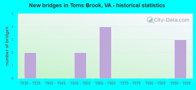
- New bridges - historical statistics
- 21930-1939
- 21950-1959
- 41960-1969
- 31990-1999

- Reconstructed bridges - Historical Statistics
- 11980-1989
- 11990-1999


- Bridge Condition - Deck
- 25.0%Very good
- 50.0%Good
- 25.0%Satisfactory

- Bridge Condition - Superstructure
- 22.2%Very good
- 44.4%Good
- 11.1%Satisfactory
- 22.2%Fair

- Bridge Condition - Substructure
- 22.2%Very good
- 22.2%Good
- 44.4%Satisfactory
- 11.1%Fair

- Bridge Condition - Channel
- 42.9%Very good
- 42.9%Good
- 14.3%Satisfactory
Find on map >> Show street view
Structure Number: 2514, Location: 8.90 TO 683 - 4.90 ALLEGH (Lat: 37.935669, Lng: -79.781617), Route carried "on" structure: County highway 629, Year Built: 1950, Status: Open, Structure Length: 1.32m (4.33ft), Average Daily Traffic: 102 (year 2020), Truck Traffic: 1%, Average Future Daily Traffic: 112 (year 2040), Design Load: H 15, Features Intersected: WILSON CREEK, Facility Carried by Structure: DOUTHAT ROAD
Minimum Vertical Clearance: 30+ m (98+ ft), Kilometerpoint: 8.402, Lanes on structure: 2, Owner: State Highway Agency, Approaching Roadway Width: 4.3m (14.1ft), Skew: 3 degrees, Material/Design: Concrete, Design/Construction: Tee Beam, Number Of Spans In Main Unit: 1, Length of Maximum Span: 12.5m (41.0ft), Curb or Sidewalk Widths: Left: 0.3m (1.0ft), Right: 0.3m (1.0ft), Curb-To-Curb Width: 5.5m (18.0ft), Out-to-Out Width: 5.9m (19.4ft)
Condition: Deck: Good, Superstructure: Satisfactory, Substructure: Satisfactory, Channel: Good, Operating Rating: 34.5 metric tons, Method Used To Determine Operating Rating: Load Factor (LF), Inventory Rating: 20.9 metric tons, Method Used To Determine Inventory Rating: Load Factor (LF), Structural Evaluation: Equal to present minimum criteria, Deck Geometry: High priority of corrective action, Waterway Adequacy: Better than present minimum criteria, Approach Roadway Alignment: Better than present minimum criteria, Length Of Structure Improvement: 1.31m (4.30ft), Designated Inspection Frequency: Every 24 months, Inspection Date: April 2020, Bridge Improvement Cost: $100,000, Roadway Improvement Cost: $50,000, Total Project Cost: $170,000, Deck Structure Type: Concrete Cast-file-Place, Wearing Surface/Protective System: Wearing Surface: Bituminous, Membrane: Epoxy
Find on map >> Show street view
Structure Number: 16951, Location: 0.11 TO 653 - 0.20 TO SCL (Lat: 38.945244, Lng: -78.441800), Route carried "on" structure: US 11, Year Built: 1934, Year Reconstructed: 1994, Status: Open, Structure Length: 1.62m (5.31ft), Average Daily Traffic: 6,550 (year 2020), Truck Traffic: 2%, Average Future Daily Traffic: 7,205 (year 2040), Design Load: HS 20+Mod, Features Intersected: TOMS BROOKS @ TOMS-BROOK, Facility Carried by Structure: SOUTH MAIN ST
Minimum Vertical Clearance: 30+ m (98+ ft), Kilometerpoint: 492.097, Lanes on structure: 2, Owner: State Highway Agency, Approaching Roadway Width: 11.9m (39.0ft), Material/Design: Prestressed concrete, Design/Construction: Slab, Number Of Spans In Main Unit: 2, Length of Maximum Span: 8.2m (26.9ft), Curb or Sidewalk Widths: Left: 1.5m (4.9ft), Right: 0.2m (0.7ft), Curb-To-Curb Width: 12.2m (40.0ft), Out-to-Out Width: 14.6m (47.9ft)
Condition: Deck: Good, Superstructure: Good, Substructure: Satisfactory, Channel: Good, Operating Rating: 84.4 metric tons, Method Used To Determine Operating Rating: Load and Resistance Factor (LRFR), Inventory Rating: 64.4 metric tons, Method Used To Determine Inventory Rating: Load and Resistance Factor (LRFR), Structural Evaluation: Equal to present minimum criteria, Deck Geometry: Somewhat better than minimum adequacy, Waterway Adequacy: Equal to present minimum criteria, Approach Roadway Alignment: Equal to present desirable criteria, Length Of Structure Improvement: 1.83m (6.00ft), Designated Inspection Frequency: Every 24 months, Inspection Date: July 2020, Bridge Improvement Cost: $151,000, Roadway Improvement Cost: $20,000, Total Project Cost: $172,000, Deck Structure Type: Other, Wearing Surface/Protective System: Wearing Surface: Bituminous
Find on map >> Show street view
Structure Number: 17148, Location: 1.80 TO 623 - 0.10 TO 757 (Lat: 38.972472, Lng: -78.428553), Route carried "on" structure: County highway 646, Year Built: 1965, Status: Open, Structure Length: 8.81m (28.90ft), Average Daily Traffic: 206 (year 2020), Average Future Daily Traffic: 227 (year 2040), Design Load: HS 20+Mod, Features Intersected: I-81, Facility Carried by Structure: MT HEBRON RD
Minimum Vertical Clearance: 30+ m (98+ ft), Kilometerpoint: 2.809, Lanes on structure: 2, Lanes under structure: 4, Owner: State Highway Agency, Approaching Roadway Width: 5.5m (18.0ft), Material/Design: Prestressed concrete, Design/Construction: Stringer/Multi-beam, Number Of Spans In Main Unit: 5, Length of Maximum Span: 18.3m (60.0ft), Curb or Sidewalk Widths: Left: 0.5m (1.6ft), Right: 0.5m (1.6ft), Curb-To-Curb Width: 7.3m (24.0ft), Out-to-Out Width: 8.8m (28.9ft)
Condition: Deck: Very good, Superstructure: Good, Substructure: Satisfactory, Operating Rating: 78.9 metric tons, Method Used To Determine Operating Rating: Load and Resistance Factor (LRFR), Inventory Rating: 56.2 metric tons, Method Used To Determine Inventory Rating: Load and Resistance Factor (LRFR), Structural Evaluation: Equal to present minimum criteria, Deck Geometry: Somewhat better than minimum adequacy, Underclear: Somewhat better than minimum adequacy, Approach Roadway Alignment: Better than present minimum criteria, Length Of Structure Improvement: 8.81m (28.90ft), Designated Inspection Frequency: Every 24 months, Inspection Date: July 2020, Bridge Improvement Cost: $80,000, Roadway Improvement Cost: $1,000, Total Project Cost: $82,000, Deck Structure Type: Concrete Cast-file-Place, Wearing Surface/Protective System: Wearing Surface: Epoxy Overlay
Find on map >> Show street view
Structure Number: 17152, Location: 0.42 TO 642 - 0.90 TO 11 (Lat: 38.965306, Lng: -78.437194), Route carried "on" structure: County highway 651, Year Built: 1965, Status: Open, Structure Length: 7.38m (24.21ft), Average Daily Traffic: 5,197 (year 2020), Truck Traffic: 4%, Average Future Daily Traffic: 5,717 (year 2040), Design Load: HS 20+Mod, Features Intersected: I-81, Facility Carried by Structure: MT OLIVE RD
Minimum Vertical Clearance: 30+ m (98+ ft), Kilometerpoint: 3.475, Lanes on structure: 2, Lanes under structure: 4, Owner: State Highway Agency, Approaching Roadway Width: 9.1m (29.9ft), Material/Design: Prestressed concrete, Design/Construction: Stringer/Multi-beam, Number Of Spans In Main Unit: 4, Length of Maximum Span: 22.6m (74.1ft), Curb or Sidewalk Widths: Left: 0.5m (1.6ft), Right: 0.5m (1.6ft), Curb-To-Curb Width: 9.1m (29.9ft), Out-to-Out Width: 10.7m (35.1ft)
Condition: Deck: Satisfactory, Superstructure: Fair, Substructure: Fair, Operating Rating: 67.1 metric tons, Method Used To Determine Operating Rating: Load and Resistance Factor (LRFR), Inventory Rating: 50.8 metric tons, Method Used To Determine Inventory Rating: Load and Resistance Factor (LRFR), Structural Evaluation: Somewhat better than minimum adequacy, Deck Geometry: Meets minimum limits, Underclear: Meets minimum limits, Approach Roadway Alignment: Better than present minimum criteria, Length Of Structure Improvement: 7.38m (24.21ft), Designated Inspection Frequency: Every 24 months, Inspection Date: Febuary 2021, Bridge Improvement Cost: $252,000, Roadway Improvement Cost: $50,000, Total Project Cost: $303,000, Deck Structure Type: Concrete Cast-file-Place, Wearing Surface/Protective System: Wearing Surface: Latex Concrete
Find on map >> Show street view
Structure Number: 1716, Location: 0.87 TO 650 - 0.10 TO 11 (Lat: 38.945369, Lng: -78.438847), Route carried "on" structure: County highway 653, Year Built: 1958, Status: Posted for load, Structure Length: 1.89m (6.20ft), Average Daily Traffic: 276 (year 2020), Truck Traffic: 2%, Average Future Daily Traffic: 304 (year 2040), Design Load: H 15, Features Intersected: TOMS BROOK, Facility Carried by Structure: EAST CREEK RD
Minimum Vertical Clearance: 30+ m (98+ ft), Kilometerpoint: 4.553, Lanes on structure: 2, Owner: State Highway Agency, Approaching Roadway Width: 5.2m (17.1ft), Material/Design: Steel, Design/Construction: Stringer/Multi-beam, Number Of Spans In Main Unit: 2, Length of Maximum Span: 9.4m (30.8ft), Curb or Sidewalk Widths: Left: 0.3m (1.0ft), Right: 0.3m (1.0ft), Curb-To-Curb Width: 6.1m (20.0ft), Out-to-Out Width: 6.8m (22.3ft)
Condition: Deck: Satisfactory, Superstructure: Fair, Substructure: Satisfactory, Channel: Satisfactory, Operating Rating: 31.8 metric tons, Method Used To Determine Operating Rating: Load Factor (LF), Inventory Rating: 19.1 metric tons, Method Used To Determine Inventory Rating: Load Factor (LF), Structural Evaluation: Somewhat better than minimum adequacy, Deck Geometry: Meets minimum limits, Waterway Adequacy: Better than present minimum criteria, Approach Roadway Alignment: Better than present minimum criteria, Bridge Posting: Required (Relationship of Operating Rating to Maximum Legal Load: 30.0 - 39.9% below), Length Of Structure Improvement: 1.89m (6.20ft), Designated Inspection Frequency: Every 24 months, Inspection Date: June 2021, Bridge Improvement Cost: $75,000, Roadway Improvement Cost: $9,000, Total Project Cost: $85,000, Deck Structure Type: Concrete Cast-file-Place
Find on map >> Show street view
Structure Number: 17318, Location: 1.33 TO 641 - 0.15 TO 646 (Lat: 38.972589, Lng: -78.424386), Route carried "on" structure: County highway 757, Year Built: 1932, Year Reconstructed: 1996, Status: Open, Structure Length: 0.70m (2.30ft), Average Daily Traffic: 225 (year 2017), Average Future Daily Traffic: 251 (year 2040), Design Load: HS 20+Mod, Features Intersected: SNAPPS RUN, Facility Carried by Structure: COPP RD
Minimum Vertical Clearance: 30+ m (98+ ft), Kilometerpoint: 0.032, Lanes on structure: 2, Owner: State Highway Agency, Approaching Roadway Width: 5.5m (18.0ft), Material/Design: Concrete, Design/Construction: Slab, Number Of Spans In Main Unit: 1, Length of Maximum Span: 6.4m (21.0ft), Curb-To-Curb Width: 6.4m (21.0ft), Out-to-Out Width: 7.3m (24.0ft)
Condition: Deck: Very good, Superstructure: Very good, Substructure: Very good, Channel: Good, Operating Rating: 79.8 metric tons, Method Used To Determine Operating Rating: Load and Resistance Factor (LRFR), Inventory Rating: 61.7 metric tons, Method Used To Determine Inventory Rating: Load and Resistance Factor (LRFR), Structural Evaluation: Equal to present desirable criteria, Deck Geometry: Meets minimum limits, Waterway Adequacy: Somewhat better than minimum adequacy, Approach Roadway Alignment: Somewhat better than minimum adequacy, Length Of Structure Improvement: 0.73m (2.40ft), Designated Inspection Frequency: Every 24 months, Inspection Date: September 2020, Bridge Improvement Cost: $35,000, Roadway Improvement Cost: $4,000, Total Project Cost: $40,000, Deck Structure Type: Other, Wearing Surface/Protective System: Wearing Surface: Epoxy Overlay
Find on map >> Show street view
Structure Number: 24267, Location: 0.70 TO 650 - 0.30 TO 11 (Lat: 38.943314, Lng: -78.437053), Route carried "on" structure: County highway 653, Year Built: 1995, Status: Open, Structure Length: 1.04m (3.41ft), Average Daily Traffic: 134 (year 2017), Average Future Daily Traffic: 149 (year 2040), Design Load: HS 20+Mod, Features Intersected: TOMS BROOK, Facility Carried by Structure: EAST CREEK RD
Minimum Vertical Clearance: 30+ m (98+ ft), Kilometerpoint: 4.827, Lanes on structure: 2, Owner: State Highway Agency, Approaching Roadway Width: 4.3m (14.1ft), Skew: 2 degrees, Material/Design: Prestressed concrete, Design/Construction: Slab, Number Of Spans In Main Unit: 1, Length of Maximum Span: 10.4m (34.1ft), Curb-To-Curb Width: 7.6m (24.9ft), Out-to-Out Width: 8.6m (28.2ft)
Condition: Deck: Good, Superstructure: Good, Substructure: Very good, Channel: Very good, Operating Rating: 71.7 metric tons, Method Used To Determine Operating Rating: Load and Resistance Factor (LRFR), Inventory Rating: 54.4 metric tons, Method Used To Determine Inventory Rating: Load and Resistance Factor (LRFR), Structural Evaluation: Better than present minimum criteria, Deck Geometry: Somewhat better than minimum adequacy, Waterway Adequacy: Equal to present minimum criteria, Approach Roadway Alignment: Somewhat better than minimum adequacy, Designated Inspection Frequency: Every 24 months, Inspection Date: July 2021, Deck Structure Type: Other, Wearing Surface/Protective System: Wearing Surface: Bituminous, Membrane: Epoxy
Find on map >> Show street view
Structure Number: 24777, Location: 0.01 Miles from Route 704 (Lat: 36.984806, Lng: -76.580586), Route carried "on" structure: County highway 1190, Year Built: 1996, Status: Open, Structure Length: 1.34m (4.40ft), Average Daily Traffic: 1,975 (year 2017), Average Future Daily Traffic: 2,884 (year 2040), Design Load: HS 20+Mod, Features Intersected: Branch Jones Creek, Facility Carried by Structure: Gatling Pointe Pky
Minimum Vertical Clearance: 30+ m (98+ ft), Kilometerpoint: 0.016, Lanes on structure: 2, Owner: State Highway Agency, Approaching Roadway Width: 7.9m (25.9ft), Material/Design: Aluminum, Iron, Design/Construction: Arch - Deck, Number Of Spans In Main Unit: 2, Length of Maximum Span: 6.1m (20.0ft), Curb-To-Curb Width: 10.0m (32.8ft), Out-to-Out Width: 11.2m (36.7ft)
Condition: Superstructure: Good, Substructure: Good, Channel: Very good, Operating Rating: 89.8 metric tons, Method Used To Determine Operating Rating: Load and Resistance Factor (LRFR), Inventory Rating: 89.8 metric tons, Method Used To Determine Inventory Rating: Load and Resistance Factor (LRFR), Structural Evaluation: Better than present minimum criteria, Deck Geometry: Somewhat better than minimum adequacy, Waterway Adequacy: Better than present minimum criteria, Approach Roadway Alignment: Equal to present desirable criteria, Designated Inspection Frequency: Every 24 months, Inspection Date: January 2021
Find on map >> Show street view
Structure Number: 24778, Location: 0.76-BOT.CL; 0.84-RTE117 (Lat: 37.351103, Lng: -79.941983), Route carried "on" structure: US 11, Year Built: 1996, Status: Open, Structure Length: 2.19m (7.19ft), Average Daily Traffic: 9,403 (year 2020), Truck Traffic: 1%, Average Future Daily Traffic: 10,343 (year 2040), Design Load: HS 20+Mod, Features Intersected: CARVINS CREEK
Minimum Vertical Clearance: 30+ m (98+ ft), Kilometerpoint: 254.578, Lanes on structure: 4, Base Highway Network: Yes, Owner: State Highway Agency, Approaching Roadway Width: 21.3m (69.9ft), Skew: 20 degrees, Material/Design: Steel, Design/Construction: Stringer/Multi-beam, Number Of Spans In Main Unit: 1, Length of Maximum Span: 21.9m (71.9ft), Curb or Sidewalk Widths: Left: 1.4m (4.6ft), Right: 1.4m (4.6ft), Curb-To-Curb Width: 21.3m (69.9ft), Out-to-Out Width: 25.0m (82.0ft)
Condition: Deck: Good, Superstructure: Very good, Substructure: Good, Channel: Very good, Operating Rating: 79.8 metric tons, Method Used To Determine Operating Rating: Load and Resistance Factor (LRFR), Inventory Rating: 61.7 metric tons, Method Used To Determine Inventory Rating: Load and Resistance Factor (LRFR), Structural Evaluation: Better than present minimum criteria, Deck Geometry: Superior to present desirable criteria, Waterway Adequacy: Somewhat better than minimum adequacy, Approach Roadway Alignment: Equal to present desirable criteria, Designated Inspection Frequency: Every 24 months, Inspection Date: October 2020, Deck Structure Type: Concrete Cast-file-Place, Wearing Surface/Protective System: Deck Protection: Epoxy Coated Reinforcing
Find on map >> Show street view
Structure Number: 17148, Location: 1.80 TO 623 - 0.10 TO 757 (Lat: 38.972472, Lng: -78.428553), Route carried "under" structure: Interstate 81, Year Built: 1965, Structure Length: 0. m, Average Daily Traffic: 42,296 (year 2008), Truck Traffic: 13%, Features Intersected: I-81, Facility Carried by Structure: MT HEBRON RD
Minimum Vertical Clearance: 5.13m (16.83ft), Kilometerpoint: 471.099, Lanes on structure: 2, Lanes under structure: 4, Material/Design: Prestressed concrete, Design/Construction: Stringer/Multi-beam, Length of Maximum Span: 18.3m (60.0ft)
Find on map >> Show street view
Structure Number: 17152, Location: 0.42 TO 642 - 0.90 TO 11 (Lat: 38.965306, Lng: -78.437194), Route carried "under" structure: Interstate 81, Year Built: 1965, Structure Length: 0. m, Average Daily Traffic: 42,296 (year 2008), Truck Traffic: 13%, Features Intersected: I-81, Facility Carried by Structure: MT OLIVE RD
Minimum Vertical Clearance: 5.26m (17.26ft), Kilometerpoint: 470.005, Lanes on structure: 2, Lanes under structure: 4, Material/Design: Prestressed concrete, Design/Construction: Stringer/Multi-beam, Length of Maximum Span: 22.6m (74.1ft)