Bridge Statistics for Toughkenamon, Pennsylvania (PA)
Condition, Traffic, Stress, Structural Evaluation, Project Costs
- National Bridge Inventory (NBI) Statistics
- 13Number of bridges
- 33ft / 10.4mTotal length
- $161,000Total costs
- 75,625Total average daily traffic
- 5,436Total average daily truck traffic
- National Bridge Inventory (NBI) Registered Bridges for Toughkenamon
- No street view available for this location
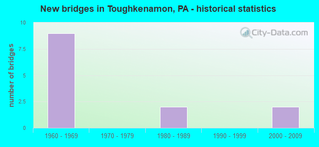
- New bridges - historical statistics
- 91960-1969
- 21980-1989
- 22000-2009


- Bridge Condition - Deck
- 25.0%Satisfactory
- 75.0%Fair

- Bridge Condition - Superstructure
- 25.0%Good
- 50.0%Satisfactory
- 25.0%Fair

- Bridge Condition - Substructure
- 50.0%Satisfactory
- 50.0%Fair

- Bridge Condition - Channel
- 50.0%Satisfactory
- 50.0%Fair
Find on map >> Show street view
Structure Number: 9908, Location: NEAR AVONDALE 46G4 (Lat: 39.846167, Lng: -75.766250), Route carried "on" structure: US 1, Year Built: 1965, Status: Open, Structure Length: 1.28m (4.20ft), Average Daily Traffic: 16,749 (year 2022), Truck Traffic: 6%, Average Future Daily Traffic: 18,446 (year 2032), Design Load: HS 20, Features Intersected: NEWARK ROAD
Minimum Vertical Clearance: 30+ m (98+ ft), Kilometerpoint: 29.567, Lanes on structure: 3, Lanes under structure: 2, Base Highway Network: Yes, Owner: State Highway Agency, Approaching Roadway Width: 16.5m (54.1ft), Skew: 10 degrees, Material/Design: Prestressed concrete, Design/Construction: Box Beam or Girders - Single/Spread, Number Of Spans In Main Unit: 1, Length of Maximum Span: 12.2m (40.0ft), Curb-To-Curb Width: 15.2m (49.9ft), Out-to-Out Width: 16.9m (55.4ft)
Condition: Deck: Fair, Superstructure: Satisfactory, Substructure: Fair, Operating Rating: 57.2 metric tons, Method Used To Determine Operating Rating: Load Factor (LF), Inventory Rating: 34.5 metric tons, Method Used To Determine Inventory Rating: Load Factor (LF), Structural Evaluation: Somewhat better than minimum adequacy, Deck Geometry: Meets minimum limits, Underclear: Somewhat better than minimum adequacy, Approach Roadway Alignment: Equal to present desirable criteria, Length Of Structure Improvement: 1.90m (6.23ft), Designated Inspection Frequency: Every 24 months, Inspection Date: April 2020, Deck Structure Type: Concrete Cast-file-Place, Wearing Surface/Protective System: Wearing Surface: Monolithic Concrete
Find on map >> Show street view
Structure Number: 9909, Location: NEAR AVONDALE 46G4 (Lat: 39.846472, Lng: -75.766361), Route carried "on" structure: US 1, Year Built: 1965, Status: Open, Structure Length: 1.28m (4.20ft), Average Daily Traffic: 10,023 (year 2020), Truck Traffic: 5%, Average Future Daily Traffic: 17,790 (year 2032), Design Load: HS 20, Features Intersected: NEWARK ROAD
Minimum Vertical Clearance: 30+ m (98+ ft), Kilometerpoint: 29.572, Lanes on structure: 3, Lanes under structure: 2, Base Highway Network: Yes, Owner: State Highway Agency, Approaching Roadway Width: 16.5m (54.1ft), Skew: 10 degrees, Material/Design: Prestressed concrete, Design/Construction: Box Beam or Girders - Single/Spread, Number Of Spans In Main Unit: 1, Length of Maximum Span: 12.2m (40.0ft), Curb-To-Curb Width: 15.2m (49.9ft), Out-to-Out Width: 16.8m (55.1ft)
Condition: Deck: Fair, Superstructure: Good, Substructure: Satisfactory, Operating Rating: 57.2 metric tons, Method Used To Determine Operating Rating: Load Factor (LF), Inventory Rating: 34.5 metric tons, Method Used To Determine Inventory Rating: Load Factor (LF), Structural Evaluation: Equal to present minimum criteria, Deck Geometry: Meets minimum limits, Underclear: Somewhat better than minimum adequacy, Approach Roadway Alignment: Equal to present desirable criteria, Length Of Structure Improvement: 1.90m (6.23ft), Designated Inspection Frequency: Every 24 months, Inspection Date: April 2020, Deck Structure Type: Concrete Cast-file-Place, Wearing Surface/Protective System: Wearing Surface: Monolithic Concrete
Find on map >> Show street view
Structure Number: 991, Location: .9 MI. N. SR 3046 46K3 (Lat: 39.850322, Lng: -75.751014), Route carried "on" structure: State highway , Year Built: 1965, Status: Open, Structure Length: 4.11m (13.48ft), Average Daily Traffic: 1,330 (year 2021), Truck Traffic: 10%, Average Future Daily Traffic: 1,093 (year 2032), Design Load: HS 20, Features Intersected: US-1 BY-PASS, Facility Carried by Structure: BANCROFT RD (T454)
Minimum Vertical Clearance: 30+ m (98+ ft), Kilometerpoint: 0.000, Lanes on structure: 2, Lanes under structure: 4, Owner: State Highway Agency, Approaching Roadway Width: 11.0m (36.1ft), Skew: 1 degrees, Material/Design: Prestressed concrete, Design/Construction: Stringer/Multi-beam, Number Of Spans In Main Unit: 2, Length of Maximum Span: 20.1m (65.9ft), Curb-To-Curb Width: 8.5m (27.9ft), Out-to-Out Width: 10.2m (33.5ft)
Condition: Deck: Fair, Superstructure: Fair, Substructure: Fair, Operating Rating: 62.6 metric tons, Method Used To Determine Operating Rating: Load Factor (LF), Inventory Rating: 29.9 metric tons, Method Used To Determine Inventory Rating: Load Factor (LF), Structural Evaluation: Somewhat better than minimum adequacy, Deck Geometry: Somewhat better than minimum adequacy, Underclear: High priority of corrective action, Approach Roadway Alignment: Equal to present desirable criteria, Length Of Structure Improvement: 5.00m (16.40ft), Designated Inspection Frequency: Every 24 months, Inspection Date: April 2020, Bridge Improvement Cost: $12,000, Roadway Improvement Cost: $35,000, Total Project Cost: $161,000, Deck Structure Type: Concrete Cast-file-Place, Wearing Surface/Protective System: Wearing Surface: Monolithic Concrete
Find on map >> Show street view
Structure Number: 54136, Location: E OF LONGO DRIVE 3911-B1 (Lat: 39.807106, Lng: -75.739583), Route carried "on" structure: Other road , Year Built: 2000, Status: Open, Structure Length: 1.28m (4.20ft), Average Daily Traffic: 500 (year 2017), Truck Traffic: 1%, Average Future Daily Traffic: 600 (year 2037), Design Load: HL 93, Features Intersected: BUCKTOE CREEK, Facility Carried by Structure: BERWICK DRIVE
Minimum Vertical Clearance: 30+ m (98+ ft), Kilometerpoint: 0.000, Lanes on structure: 2, Owner: Town or Township Highway Agency, Approaching Roadway Width: 7.3m (24.0ft), Skew: 5 degrees, Material/Design: Steel, Design/Construction: Culvert, Number Of Spans In Main Unit: 1, Length of Maximum Span: 12.8m (42.0ft), Curb or Sidewalk Widths: Left: 0.0m, Right: 1.5m (4.9ft)
Condition: Channel: Satisfactory, Culverts: Good, Operating Rating: 86.2 metric tons, Method Used To Determine Operating Rating: Field evaluation and documented engineering judgment, Inventory Rating: 51.7 metric tons, Method Used To Determine Inventory Rating: Field evaluation and documented engineering judgment, Structural Evaluation: Better than present minimum criteria, Waterway Adequacy: Better than present minimum criteria, Approach Roadway Alignment: Equal to present desirable criteria, Designated Inspection Frequency: Every 24 months, Inspection Date: Febuary 2021
Find on map >> Show street view
Structure Number: 54137, Location: E OF PENN RD 3910H02 (Lat: 39.803128, Lng: -75.763111), Route carried "on" structure: Other road , Year Built: 2000, Status: Open, Structure Length: 0.73m (2.40ft), Average Daily Traffic: 1,000 (year 2017), Truck Traffic: 1%, Average Future Daily Traffic: 1,300 (year 2037), Design Load: HL 93, Features Intersected: WHISKEY RUN, Facility Carried by Structure: STARR ROAD
Minimum Vertical Clearance: 30+ m (98+ ft), Kilometerpoint: 0.000, Lanes on structure: 2, Owner: Town or Township Highway Agency, Approaching Roadway Width: 7.9m (25.9ft), Material/Design: Concrete, Design/Construction: Culvert, Number Of Spans In Main Unit: 1, Length of Maximum Span: 7.3m (24.0ft), Curb or Sidewalk Widths: Left: 0.4m (1.3ft), Right: 0.4m (1.3ft), Curb-To-Curb Width: 8.7m (28.5ft), Out-to-Out Width: 9.4m (30.8ft)
Condition: Channel: Fair, Culverts: Good, Operating Rating: 86.2 metric tons, Method Used To Determine Operating Rating: Field evaluation and documented engineering judgment, Inventory Rating: 51.7 metric tons, Method Used To Determine Inventory Rating: Field evaluation and documented engineering judgment, Structural Evaluation: Better than present minimum criteria, Deck Geometry: Somewhat better than minimum adequacy, Waterway Adequacy: Better than present minimum criteria, Approach Roadway Alignment: Equal to present desirable criteria, Designated Inspection Frequency: Every 24 months, Inspection Date: Febuary 2021
Find on map >> Show street view
Structure Number: 54159, Location: W OF CHURCH RD 3800E05 (Lat: 39.849967, Lng: -75.783908), Route carried "on" structure: City street , Year Built: 1980, Status: Open, Structure Length: 1.10m (3.61ft), Average Daily Traffic: 500 (year 2017), Truck Traffic: 10%, Average Future Daily Traffic: 1,000 (year 2035), Design Load: HS 20, Features Intersected: E BR OF WHITE CLAY CREEK, Facility Carried by Structure: MCCUE ROAD
Minimum Vertical Clearance: 30+ m (98+ ft), Kilometerpoint: 0.000, Lanes on structure: 2, Owner: Town or Township Highway Agency, Approaching Roadway Width: 6.4m (21.0ft), Skew: 1 degrees, Material/Design: Steel, Design/Construction: Stringer/Multi-beam, Number Of Spans In Main Unit: 1, Length of Maximum Span: 10.4m (34.1ft), Curb-To-Curb Width: 6.2m (20.3ft), Out-to-Out Width: 6.4m (21.0ft)
Condition: Deck: Satisfactory, Superstructure: Satisfactory, Substructure: Satisfactory, Channel: Satisfactory, Operating Rating: 52.6 metric tons, Method Used To Determine Operating Rating: Load Factor (LF), Inventory Rating: 31.8 metric tons, Method Used To Determine Inventory Rating: Load Factor (LF), Structural Evaluation: Equal to present minimum criteria, Deck Geometry: High priority of corrective action, Waterway Adequacy: Equal to present desirable criteria, Approach Roadway Alignment: Equal to present minimum criteria, Designated Inspection Frequency: Every 24 months, Inspection Date: May 2021, Deck Structure Type: Concrete Cast-file-Place, Wearing Surface/Protective System: Wearing Surface: Monolithic Concrete, Deck Protection: Epoxy Coated Reinforcing
Find on map >> Show street view
Structure Number: 54251, Location: S of Cypress St 3801B7 (Lat: 39.836797, Lng: -75.738319), Route carried "on" structure: Other road , Year Built: 1980, Status: Open, Structure Length: 0.64m (2.10ft), Average Daily Traffic: 500 (year 2017), Truck Traffic: 2%, Average Future Daily Traffic: 650 (year 2037), Design Load: HS 20, Features Intersected: SCARLET RUN, Facility Carried by Structure: THOMPSON ROAD
Minimum Vertical Clearance: 30+ m (98+ ft), Kilometerpoint: 0.000, Lanes on structure: 2, Owner: Town or Township Highway Agency, Approaching Roadway Width: 5.2m (17.1ft), Skew: 1 degrees, Material/Design: Concrete, Design/Construction: Culvert, Number Of Spans In Main Unit: 1, Length of Maximum Span: 6.4m (21.0ft), Curb or Sidewalk Widths: Left: 0.5m (1.6ft), Right: 0.5m (1.6ft), Curb-To-Curb Width: 5.5m (18.0ft), Out-to-Out Width: 6.7m (22.0ft)
Condition: Channel: Fair, Culverts: Good, Operating Rating: 82.6 metric tons, Method Used To Determine Operating Rating: Field evaluation and documented engineering judgment, Inventory Rating: 49.9 metric tons, Method Used To Determine Inventory Rating: Field evaluation and documented engineering judgment, Structural Evaluation: Better than present minimum criteria, Deck Geometry: High priority of replacement, Waterway Adequacy: Better than present minimum criteria, Approach Roadway Alignment: Equal to present desirable criteria, Designated Inspection Frequency: Every 24 months, Inspection Date: March 2021
Find on map >> Show street view
Structure Number: 9906, Location: NEAR AVONDALE 46F04 (Lat: 39.845389, Lng: -75.774861), Route carried "under" structure: State highway , Year Built: 1965, Structure Length: 0. m, Average Daily Traffic: 1,245 (year 2020), Truck Traffic: 7%, Features Intersected: CHURCH ROAD, Facility Carried by Structure: US 1 BY-PASS (NB)
Minimum Vertical Clearance: 4.32m (14.17ft), Kilometerpoint: 2.482, Lanes on structure: 2, Lanes under structure: 2, Material/Design: Prestressed concrete, Design/Construction: Stringer/Multi-beam, Length of Maximum Span: 25.9m (85.0ft)
Find on map >> Show street view
Structure Number: 9907, Location: NEAR AVONDALE 46F04 (Lat: 39.845617, Lng: -75.774778), Route carried "under" structure: State highway , Year Built: 1965, Structure Length: 0. m, Average Daily Traffic: 1,245 (year 2020), Truck Traffic: 7%, Features Intersected: CHURCH ROAD, Facility Carried by Structure: US-1 BYPASS (SB)
Minimum Vertical Clearance: 4.54m (14.90ft), Kilometerpoint: 2.482, Lanes on structure: 2, Lanes under structure: 2, Material/Design: Prestressed concrete, Design/Construction: Stringer/Multi-beam, Length of Maximum Span: 26.5m (86.9ft)
Find on map >> Show street view
Structure Number: 9908, Location: NEAR AVONDALE 46G4 (Lat: 39.846167, Lng: -75.766250), Route carried "under" structure: State highway , Year Built: 1965, Structure Length: 0. m, Average Daily Traffic: 4,820 (year 2022), Truck Traffic: 8%, Features Intersected: NEWARK ROAD, Facility Carried by Structure: US 1 BY-PASS (NB)
Minimum Vertical Clearance: 4.65m (15.26ft), Kilometerpoint: 6.606, Lanes on structure: 3, Lanes under structure: 2, Material/Design: Prestressed concrete, Design/Construction: Box Beam or Girders - Single/Spread, Length of Maximum Span: 12.2m (40.0ft)
Find on map >> Show street view
Structure Number: 9909, Location: NEAR AVONDALE 46G4 (Lat: 39.846472, Lng: -75.766361), Route carried "under" structure: State highway , Year Built: 1965, Structure Length: 0. m, Average Daily Traffic: 4,820 (year 2022), Truck Traffic: 8%, Features Intersected: NEWARK ROAD, Facility Carried by Structure: US 1 BY-PASS (SB)
Minimum Vertical Clearance: 5.21m (17.09ft), Kilometerpoint: 6.606, Lanes on structure: 3, Lanes under structure: 2, Material/Design: Prestressed concrete, Design/Construction: Box Beam or Girders - Single/Spread, Length of Maximum Span: 12.2m (40.0ft)
Find on map >> Show street view
Structure Number: 991, Location: .9 MI. N. SR 3046 46K3 (Lat: 39.850322, Lng: -75.751014), Route carried "under" structure: US 1, Year Built: 1965, Structure Length: 0. m, Average Daily Traffic: 16,749 (year 2022), Truck Traffic: 6%, Features Intersected: US-1 BY-PASS, Facility Carried by Structure: BANCROFT RD (T454)
Minimum Vertical Clearance: 4.95m (16.24ft), Kilometerpoint: 30.957, Lanes on structure: 2, Lanes under structure: 2, Material/Design: Prestressed concrete, Design/Construction: Stringer/Multi-beam, Length of Maximum Span: 20.1m (65.9ft)
Find on map >> Show street view
Structure Number: 991, Location: .9 MI. N. SR 3046 46K3 (Lat: 39.850322, Lng: -75.751014), Route carried "under" structure: US 1, Year Built: 1965, Structure Length: 0. m, Average Daily Traffic: 16,144 (year 2022), Truck Traffic: 11%, Features Intersected: US-1 BY-PASS, Facility Carried by Structure: BANCROFT RD (T454)
Minimum Vertical Clearance: 4.50m (14.76ft), Kilometerpoint: 30.972, Lanes on structure: 2, Lanes under structure: 2, Material/Design: Prestressed concrete, Design/Construction: Stringer/Multi-beam, Length of Maximum Span: 20.1m (65.9ft)