Bridge Statistics for Town and Country, Missouri (MO)
Condition, Traffic, Stress, Structural Evaluation, Project Costs
- National Bridge Inventory (NBI) Statistics
- 51Number of bridges
- 581ft / 177mTotal length
- $6,445,000Total costs
- 1,481,861Total average daily traffic
- 164,179Total average daily truck traffic
- National Bridge Inventory (NBI) Registered Bridges for Town and Country
- No street view available for this location
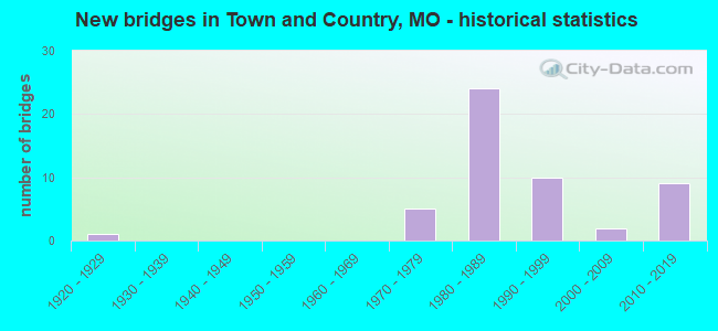
- New bridges - historical statistics
- 11920-1929
- 51970-1979
- 241980-1989
- 101990-1999
- 22000-2009
- 92010-2019


- Bridge Condition - Deck
- 10.5%Very good
- 47.4%Good
- 26.3%Satisfactory
- 10.5%Fair
- 5.3%Poor

- Bridge Condition - Superstructure
- 21.1%Very good
- 47.4%Good
- 15.8%Satisfactory
- 10.5%Fair
- 5.3%Poor

- Bridge Condition - Substructure
- 10.5%Very good
- 47.4%Good
- 26.3%Satisfactory
- 10.5%Fair
- 5.3%Poor

- Bridge Condition - Channel
- 11.8%Very good
- 23.5%Good
- 41.2%Satisfactory
- 23.5%Fair

- Bridge Condition - Culverts
- 80.0%Satisfactory
- 20.0%Fair
Find on map >> Show street view
Structure Number: 12031, Location: S 34 T 45 N R 5 E (Lat: 38.603825, Lng: -90.451939), Route carried "on" structure: State highway 100, Year Built: 1999, Status: Open, Structure Length: 45.45m (149.11ft), Average Daily Traffic: 22,580 (year 2021), Truck Traffic: 9%, Average Future Daily Traffic: 31,612 (year 2041), Design Load: HS 25 or greater, Features Intersected: IS 270, RP IS270W TO MO1
Minimum Vertical Clearance: 30+ m (98+ ft), Kilometerpoint: 23.270, Lanes on structure: 4, Lanes under structure: 13, Base Highway Network: Yes, Owner: State Highway Agency, Approaching Roadway Width: 19.5m (64.0ft), Skew: 1 degrees, Material/Design: Steel continuous, Design/Construction: Stringer/Multi-beam, Number Of Spans In Main Unit: 19, Length of Maximum Span: 41.0m (134.5ft), Curb-To-Curb Width: 19.5m (64.0ft), Out-to-Out Width: 20.4m (66.9ft)
Condition: Deck: Satisfactory, Superstructure: Good, Substructure: Good, Operating Rating: 67.5 metric tons, Method Used To Determine Operating Rating: Load Factor (LF), Inventory Rating: 40.5 metric tons, Method Used To Determine Inventory Rating: Load Factor (LF), Structural Evaluation: Better than present minimum criteria, Deck Geometry: Better than present minimum criteria, Underclear: Meets minimum limits, Approach Roadway Alignment: Equal to present desirable criteria, Designated Inspection Frequency: Every 24 months, Inspection Date: June 2020, Deck Structure Type: Concrete Cast-file-Place, Wearing Surface/Protective System: Wearing Surface: Monolithic Concrete, Deck Protection: Epoxy Coated Reinforcing
Find on map >> Show street view
Structure Number: 156, Location: S 32 T 45 N R 5 E (Lat: 38.598475, Lng: -90.491083), Route carried "on" structure: County highway , Year Built: 1973, Status: Posted for load, Structure Length: 2.29m (7.51ft), Average Daily Traffic: 3,173 (year 2020), Truck Traffic: 10%, Average Future Daily Traffic: 4,284 (year 2040), Design Load: H 20, Features Intersected: BR GRAND GLAIZE CR, Facility Carried by Structure: WYNCREST DR
Minimum Vertical Clearance: 30+ m (98+ ft), Kilometerpoint: 10.622, Lanes on structure: 2, Owner: County Highway Agency, Approaching Roadway Width: 7.6m (24.9ft), Material/Design: Steel, Design/Construction: Stringer/Multi-beam, Number Of Spans In Main Unit: 1, Length of Maximum Span: 21.3m (69.9ft), Curb or Sidewalk Widths: Left: 1.2m (3.9ft), Right: 1.2m (3.9ft), Curb-To-Curb Width: 7.9m (25.9ft), Out-to-Out Width: 11.0m (36.1ft)
Condition: Deck: Fair, Superstructure: Fair, Substructure: Satisfactory, Channel: Satisfactory, Operating Rating: 63.0 metric tons, Method Used To Determine Operating Rating: Allowable Stress (AS), Inventory Rating: 22.5 metric tons, Method Used To Determine Inventory Rating: Allowable Stress (AS), Structural Evaluation: Somewhat better than minimum adequacy, Deck Geometry: High priority of corrective action, Waterway Adequacy: Superior to present desirable criteria, Approach Roadway Alignment: Equal to present minimum criteria, Length Of Structure Improvement: 0.31m (1.02ft), Designated Inspection Frequency: Every 24 months, Inspection Date: March 2021, Bridge Improvement Cost: $392,000, Roadway Improvement Cost: $39,000, Total Project Cost: $587,000 ( Estimate for 2022), Deck Structure Type: Concrete Cast-file-Place, Wearing Surface/Protective System: Wearing Surface: Monolithic Concrete, Membrane: Epoxy
Find on map >> Show street view
Structure Number: 15609, Location: S 31 T 45 N R 5 E (Lat: 38.592811, Lng: -90.493075), Route carried "on" structure: County highway , Year Built: 1973, Status: Posted for load, Structure Length: 2.53m (8.30ft), Average Daily Traffic: 8,214 (year 2020), Truck Traffic: 2%, Average Future Daily Traffic: 11,089 (year 2040), Design Load: HS 20, Features Intersected: GRAND GLAIZE CR, Facility Carried by Structure: WEIDMAN RD
Minimum Vertical Clearance: 30+ m (98+ ft), Kilometerpoint: 10.622, Lanes on structure: 2, Owner: County Highway Agency, Approaching Roadway Width: 11.6m (38.1ft), Material/Design: Prestressed concrete, Design/Construction: Box Beam or Girders - Multiple, Number Of Spans In Main Unit: 3, Length of Maximum Span: 11.6m (38.1ft), Curb or Sidewalk Widths: Left: 1.2m (3.9ft), Right: 1.2m (3.9ft), Curb-To-Curb Width: 11.6m (38.1ft), Out-to-Out Width: 14.0m (45.9ft)
Condition: Deck: Poor, Superstructure: Poor, Substructure: Poor, Channel: Fair, Operating Rating: 63.0 metric tons, Method Used To Determine Operating Rating: Allowable Stress (AS), Inventory Rating: 22.5 metric tons, Method Used To Determine Inventory Rating: Allowable Stress (AS), Structural Evaluation: Meets minimum limits, Deck Geometry: Somewhat better than minimum adequacy, Waterway Adequacy: Superior to present desirable criteria, Approach Roadway Alignment: Equal to present minimum criteria, Length Of Structure Improvement: 0.34m (1.12ft), Designated Inspection Frequency: Every 24 months, Inspection Date: March 2021, Bridge Improvement Cost: $292,000, Roadway Improvement Cost: $29,000, Total Project Cost: $439,000 ( Estimate for 2022), Deck Structure Type: Other, Wearing Surface/Protective System: Wearing Surface: Bituminous
Find on map >> Show street view
Structure Number: 1561, Location: S 32 T 45 N R 5 E (Lat: 38.595164, Lng: -90.487450), Route carried "on" structure: County highway , Year Built: 1997, Status: Posted for load, Structure Length: 3.44m (11.29ft), Average Daily Traffic: 4,077 (year 2020), Truck Traffic: 2%, Average Future Daily Traffic: 5,504 (year 2040), Design Load: HS 20, Features Intersected: GRAND GLAIZE CR, Facility Carried by Structure: DIETRICH RD
Minimum Vertical Clearance: 30+ m (98+ ft), Kilometerpoint: 10.783, Lanes on structure: 2, Owner: County Highway Agency, Approaching Roadway Width: 11.6m (38.1ft), Material/Design: Prestressed concrete continuous, Design/Construction: Stringer/Multi-beam, Number Of Spans In Main Unit: 3, Length of Maximum Span: 15.2m (49.9ft), Curb or Sidewalk Widths: Left: 1.5m (4.9ft), Right: 1.5m (4.9ft), Curb-To-Curb Width: 13.4m (44.0ft), Out-to-Out Width: 17.3m (56.8ft)
Condition: Deck: Good, Superstructure: Good, Substructure: Satisfactory, Channel: Satisfactory, Operating Rating: 89.1 metric tons, Method Used To Determine Operating Rating: Load Factor (LF), Inventory Rating: 65.7 metric tons, Method Used To Determine Inventory Rating: Load Factor (LF), Structural Evaluation: Equal to present minimum criteria, Deck Geometry: Better than present minimum criteria, Waterway Adequacy: Superior to present desirable criteria, Approach Roadway Alignment: Better than present minimum criteria, Designated Inspection Frequency: Every 24 months, Inspection Date: March 2021, Deck Structure Type: Concrete Cast-file-Place, Wearing Surface/Protective System: Wearing Surface: Monolithic Concrete, Membrane: Other, Deck Protection: Epoxy Coated Reinforcing
Find on map >> Show street view
Structure Number: 2369, Location: S 36 T 61 N R 40 W (Lat: 40.051483, Lng: -95.362406), Route carried "on" structure: US 159, Year Built: 1974, Year Reconstructed: 2021, Status: Open, Structure Length: 3.17m (10.40ft), Average Daily Traffic: 1,048 (year 2021), Truck Traffic: 21%, Average Future Daily Traffic: 1,415 (year 2041), Design Load: H 20, Features Intersected: BIG LK OVRFL
Minimum Vertical Clearance: 30+ m (98+ ft), Kilometerpoint: 22.985, Lanes on structure: 2, Base Highway Network: Yes, Owner: State Highway Agency, Approaching Roadway Width: 7.3m (24.0ft), Material/Design: Concrete continuous, Design/Construction: Slab, Number Of Spans In Main Unit: 3, Length of Maximum Span: 12.8m (42.0ft), Curb-To-Curb Width: 10.4m (34.1ft), Out-to-Out Width: 11.2m (36.7ft)
Condition: Deck: Good, Superstructure: Good, Substructure: Good, Channel: Fair, Operating Rating: 58.5 metric tons, Method Used To Determine Operating Rating: Load Factor (LF), Inventory Rating: 35.1 metric tons, Method Used To Determine Inventory Rating: Load Factor (LF), Structural Evaluation: Better than present minimum criteria, Deck Geometry: Equal to present minimum criteria, Waterway Adequacy: Equal to present minimum criteria, Approach Roadway Alignment: Equal to present desirable criteria, Designated Inspection Frequency: Every 24 months, Inspection Date: November 2021, Deck Structure Type: Concrete Cast-file-Place, Wearing Surface/Protective System: Wearing Surface: Latex Concrete, Membrane: Built-up, Deck Protection: Bituminous
Find on map >> Show street view
Structure Number: 2369, Location: S 20 T 45 N R 5 E (Lat: 38.614694, Lng: -90.475806), Route carried "on" structure: City street , Year Built: 1973, Status: Posted for load, Structure Length: 0.88m (2.89ft), Average Daily Traffic: 500 (year 2020), Truck Traffic: 1%, Average Future Daily Traffic: 675 (year 2040), Design Load: HS 20, Features Intersected: BR OF GRAND GLAIZE, Facility Carried by Structure: FEATHERSTONE DR
Minimum Vertical Clearance: 30+ m (98+ ft), Kilometerpoint: 0.161, Lanes on structure: 2, Owner: City or Municipal Highway Agency, Approaching Roadway Width: 7.9m (25.9ft), Material/Design: Concrete continuous, Design/Construction: Culvert, Number Of Spans In Main Unit: 2, Length of Maximum Span: 3.4m (11.2ft)
Condition: Channel: Satisfactory, Culverts: Satisfactory, Operating Rating: 35.1 metric tons, Method Used To Determine Operating Rating: Allowable Stress (AS), Inventory Rating: 22.5 metric tons, Method Used To Determine Inventory Rating: Allowable Stress (AS), Structural Evaluation: Equal to present minimum criteria, Waterway Adequacy: Better than present minimum criteria, Approach Roadway Alignment: Equal to present desirable criteria, Designated Inspection Frequency: Every 24 months, Inspection Date: December 2021
Find on map >> Show street view
Structure Number: 23691, Location: S 20 T 45 N R 5 E (Lat: 38.612100, Lng: -90.476078), Route carried "on" structure: City street , Year Built: 1979, Status: Posted for load, Structure Length: 0.82m (2.69ft), Average Daily Traffic: 40 (year 2020), Truck Traffic: 5%, Average Future Daily Traffic: 54 (year 2040), Design Load: HS 20, Features Intersected: BR OF GRAND GLAIZE, Facility Carried by Structure: MASON KNOLL DR
Minimum Vertical Clearance: 30+ m (98+ ft), Kilometerpoint: 0.322, Lanes on structure: 2, Owner: City or Municipal Highway Agency, Approaching Roadway Width: 7.9m (25.9ft), Material/Design: Concrete continuous, Design/Construction: Culvert, Number Of Spans In Main Unit: 2, Length of Maximum Span: 3.7m (12.1ft)
Condition: Channel: Satisfactory, Culverts: Satisfactory, Operating Rating: 35.1 metric tons, Method Used To Determine Operating Rating: Allowable Stress (AS), Inventory Rating: 22.5 metric tons, Method Used To Determine Inventory Rating: Allowable Stress (AS), Structural Evaluation: Equal to present minimum criteria, Waterway Adequacy: Better than present minimum criteria, Approach Roadway Alignment: Equal to present desirable criteria, Designated Inspection Frequency: Every 24 months, Inspection Date: December 2021
Find on map >> Show street view
Structure Number: 23692, Location: S 32 T 45 N R 5 E (Lat: 38.600083, Lng: -90.473944), Route carried "on" structure: City street , Year Built: 1980, Status: Posted for load, Structure Length: 0.85m (2.79ft), Average Daily Traffic: 500 (year 2020), Truck Traffic: 1%, Average Future Daily Traffic: 675 (year 2040), Design Load: HS 20+Mod, Features Intersected: BR OF GRAND GLAIZE, Facility Carried by Structure: BARRETT STA RD
Minimum Vertical Clearance: 30+ m (98+ ft), Kilometerpoint: 0.483, Lanes on structure: 2, Owner: City or Municipal Highway Agency, Approaching Roadway Width: 6.7m (22.0ft), Material/Design: Concrete continuous, Design/Construction: Culvert, Number Of Spans In Main Unit: 2, Length of Maximum Span: 4.0m (13.1ft), Curb-To-Curb Width: 7.5m (24.6ft), Out-to-Out Width: 12.2m (40.0ft)
Condition: Channel: Satisfactory, Culverts: Satisfactory, Operating Rating: 35.1 metric tons, Method Used To Determine Operating Rating: Allowable Stress (AS), Inventory Rating: 22.5 metric tons, Method Used To Determine Inventory Rating: Allowable Stress (AS), Structural Evaluation: Equal to present minimum criteria, Deck Geometry: Meets minimum limits, Waterway Adequacy: Better than present minimum criteria, Approach Roadway Alignment: Equal to present desirable criteria, Designated Inspection Frequency: Every 24 months, Inspection Date: December 2021
Find on map >> Show street view
Structure Number: 29103, Location: S 31 T 45 N R 5 E (Lat: 38.617956, Lng: -90.498228), Route carried "on" structure: County highway , Year Built: 2001, Status: Posted for load, Structure Length: 3.23m (10.60ft), Average Daily Traffic: 4,626 (year 2020), Truck Traffic: 2%, Average Future Daily Traffic: 6,245 (year 2040), Design Load: HS 25 or greater, Features Intersected: GRAND GLAIZE CR, Facility Carried by Structure: WEIDMAN RD
Minimum Vertical Clearance: 30+ m (98+ ft), Kilometerpoint: 0.000, Lanes on structure: 3, Owner: County Highway Agency, Approaching Roadway Width: 11.6m (38.1ft), Skew: 4 degrees, Material/Design: Steel, Design/Construction: Stringer/Multi-beam, Number Of Spans In Main Unit: 1, Length of Maximum Span: 31.1m (102.0ft), Curb or Sidewalk Widths: Left: 2.0m (6.6ft), Right: 2.0m (6.6ft), Curb-To-Curb Width: 15.0m (49.2ft), Out-to-Out Width: 20.2m (66.3ft)
Condition: Deck: Good, Superstructure: Good, Substructure: Good, Channel: Satisfactory, Inventory Rating: 74.7 metric tons, Method Used To Determine Inventory Rating: Load Factor (LF), Structural Evaluation: Better than present minimum criteria, Deck Geometry: Equal to present minimum criteria, Waterway Adequacy: Superior to present desirable criteria, Approach Roadway Alignment: Equal to present desirable criteria, Designated Inspection Frequency: Every 24 months, Inspection Date: March 2021, Deck Structure Type: Concrete Cast-file-Place, Wearing Surface/Protective System: Wearing Surface: Monolithic Concrete, Membrane: Other, Deck Protection: Epoxy Coated Reinforcing
Find on map >> Show street view
Structure Number: 30518, Location: S 28 T 45 N R 5 E (Lat: 38.605417, Lng: -90.462639), Route carried "on" structure: City street , Year Built: 2004, Status: Open, Structure Length: 0.73m (2.40ft), Average Daily Traffic: 2,021 (year 2021), Truck Traffic: 4%, Average Future Daily Traffic: 3,032 (year 2041), Design Load: HS 20, Features Intersected: DITCH, Facility Carried by Structure: TOPPING RD N
Minimum Vertical Clearance: 30+ m (98+ ft), Kilometerpoint: 0.299, Lanes on structure: 2, Owner: State Highway Agency, Approaching Roadway Width: 9.6m (31.5ft), Skew: 2 degrees, Material/Design: Concrete continuous, Design/Construction: Culvert, Number Of Spans In Main Unit: 2, Length of Maximum Span: 3.0m (9.8ft)
Condition: Channel: Fair, Culverts: Satisfactory, Operating Rating: 87.3 metric tons, Method Used To Determine Operating Rating: Field evaluation and documented engineering judgment, Inventory Rating: 52.2 metric tons, Method Used To Determine Inventory Rating: Field evaluation and documented engineering judgment, Structural Evaluation: Equal to present minimum criteria, Waterway Adequacy: Superior to present desirable criteria, Approach Roadway Alignment: Equal to present desirable criteria, Designated Inspection Frequency: Every 24 months, Inspection Date: November 2021
Find on map >> Show street view
Structure Number: 32964, Location: S 109 T 45 N R 5 E (Lat: 38.661358, Lng: -90.502850), Route carried "on" structure: Ramp State highway , Year Built: 2010, Status: Open, Structure Length: 15.52m (50.92ft), Average Daily Traffic: 1,156 (year 2021), Truck Traffic: 5%, Average Future Daily Traffic: 1,445 (year 2041), Features Intersected: CREVE COEUR CR, Facility Carried by Structure: RP RTABE TO MO141N
Minimum Vertical Clearance: 30+ m (98+ ft), Kilometerpoint: 0.159, Lanes on structure: 1, Base Highway Network: Yes, Owner: State Highway Agency, Approaching Roadway Width: 7.3m (24.0ft), Skew: 2 degrees, Material/Design: Prestressed concrete continuous, Design/Construction: Stringer/Multi-beam, Number Of Spans In Main Unit: 7, Length of Maximum Span: 25.9m (85.0ft), Curb-To-Curb Width: 7.3m (24.0ft), Out-to-Out Width: 8.1m (26.6ft)
Condition: Deck: Good, Superstructure: Good, Substructure: Good, Channel: Good, Operating Rating: 96.3 metric tons, Method Used To Determine Operating Rating: Load Factor (LF), Inventory Rating: 41.4 metric tons, Method Used To Determine Inventory Rating: Load Factor (LF), Structural Evaluation: Better than present minimum criteria, Deck Geometry: Better than present minimum criteria, Waterway Adequacy: Superior to present desirable criteria, Approach Roadway Alignment: Equal to present desirable criteria, Designated Inspection Frequency: Every 48 months, Inspection Date: October 2018, Deck Structure Type: Concrete Cast-file-Place, Wearing Surface/Protective System: Wearing Surface: Monolithic Concrete, Deck Protection: Epoxy Coated Reinforcing
Find on map >> Show street view
Structure Number: 3297, Location: S 109 T 45 N R 5 E (Lat: 38.661969, Lng: -90.502978), Route carried "on" structure: State highway 141, Year Built: 2011, Status: Open, Structure Length: 15.01m (49.25ft), Average Daily Traffic: 12,393 (year 2021), Truck Traffic: 5%, Average Future Daily Traffic: 15,491 (year 2041), Features Intersected: CREVE COUER CR
Minimum Vertical Clearance: 30+ m (98+ ft), Kilometerpoint: 17.257, Lanes on structure: 4, Base Highway Network: Yes, Owner: State Highway Agency, Approaching Roadway Width: 21.9m (71.9ft), Skew: 32 degrees, Material/Design: Prestressed concrete continuous, Design/Construction: Stringer/Multi-beam, Number Of Spans In Main Unit: 7, Length of Maximum Span: 25.9m (85.0ft), Curb-To-Curb Width: 21.9m (71.9ft), Out-to-Out Width: 23.4m (76.8ft)
Condition: Deck: Good, Superstructure: Good, Substructure: Good, Channel: Good, Operating Rating: 69.3 metric tons, Method Used To Determine Operating Rating: Load Factor (LF), Inventory Rating: 36.0 metric tons, Method Used To Determine Inventory Rating: Load Factor (LF), Structural Evaluation: Better than present minimum criteria, Deck Geometry: Better than present minimum criteria, Waterway Adequacy: Superior to present desirable criteria, Approach Roadway Alignment: Equal to present desirable criteria, Designated Inspection Frequency: Every 24 months, Inspection Date: October 2020, Deck Structure Type: Concrete Cast-file-Place, Wearing Surface/Protective System: Wearing Surface: Monolithic Concrete, Deck Protection: Epoxy Coated Reinforcing
Find on map >> Show street view
Structure Number: 32971, Location: S 109 T 45 N R 5 E (Lat: 38.661939, Lng: -90.503200), Route carried "on" structure: Ramp State highway , Year Built: 2011, Status: Open, Structure Length: 14.71m (48.26ft), Average Daily Traffic: 526 (year 2021), Truck Traffic: 5%, Average Future Daily Traffic: 658 (year 2041), Features Intersected: CREVE COUER CR, Facility Carried by Structure: RP MO141S TO RTABE
Minimum Vertical Clearance: 30+ m (98+ ft), Kilometerpoint: 0.116, Lanes on structure: 1, Base Highway Network: Yes, Owner: State Highway Agency, Approaching Roadway Width: 7.3m (24.0ft), Skew: 2 degrees, Material/Design: Prestressed concrete continuous, Design/Construction: Stringer/Multi-beam, Number Of Spans In Main Unit: 6, Length of Maximum Span: 25.9m (85.0ft), Curb-To-Curb Width: 7.3m (24.0ft), Out-to-Out Width: 8.1m (26.6ft)
Condition: Deck: Good, Superstructure: Very good, Substructure: Good, Channel: Good, Operating Rating: 72.0 metric tons, Method Used To Determine Operating Rating: Load Factor (LF), Inventory Rating: 38.7 metric tons, Method Used To Determine Inventory Rating: Load Factor (LF), Structural Evaluation: Better than present minimum criteria, Deck Geometry: Better than present minimum criteria, Waterway Adequacy: Superior to present desirable criteria, Approach Roadway Alignment: Equal to present desirable criteria, Designated Inspection Frequency: Every 48 months, Inspection Date: October 2018, Deck Structure Type: Concrete Cast-file-Place, Wearing Surface/Protective System: Wearing Surface: Monolithic Concrete, Deck Protection: Epoxy Coated Reinforcing
Find on map >> Show street view
Structure Number: 3343, Location: S 13 T 45 N R 4 E (Lat: 38.642344, Lng: -90.510328), Route carried "on" structure: Interstate 64, Year Built: 1985, Status: Open, Structure Length: 7.25m (23.79ft), Average Daily Traffic: 64,994 (year 2021), Truck Traffic: 8%, Average Future Daily Traffic: 81,243 (year 2041), Design Load: HS 20+Mod, Features Intersected: CO NORTH FORTY DR TO SOR
Minimum Vertical Clearance: 30+ m (98+ ft), Kilometerpoint: 29.337, Lanes on structure: 4, Lanes under structure: 10, Base Highway Network: Yes, Owner: State Highway Agency, Approaching Roadway Width: 15.8m (51.8ft), Skew: 10 degrees, Material/Design: Steel continuous, Design/Construction: Stringer/Multi-beam, Number Of Spans In Main Unit: 3, Length of Maximum Span: 30.5m (100.1ft), Curb or Sidewalk Widths: Left: 0.2m (0.7ft), Right: 0.2m (0.7ft), Curb-To-Curb Width: 15.2m (49.9ft), Out-to-Out Width: 16.0m (52.5ft)
Condition: Deck: Satisfactory, Superstructure: Satisfactory, Substructure: Satisfactory, Operating Rating: 56.7 metric tons, Method Used To Determine Operating Rating: Load Factor (LF), Inventory Rating: 34.2 metric tons, Method Used To Determine Inventory Rating: Load Factor (LF), Structural Evaluation: Equal to present minimum criteria, Deck Geometry: High priority of replacement, Underclear: Meets minimum limits, Approach Roadway Alignment: Equal to present desirable criteria, Length Of Structure Improvement: 0.83m (2.72ft), Designated Inspection Frequency: Every 24 months, Inspection Date: October 2020, Bridge Improvement Cost: $1,076,000, Roadway Improvement Cost: $108,000, Total Project Cost: $1,615,000 ( Estimate for 2022), Deck Structure Type: Concrete Cast-file-Place, Wearing Surface/Protective System: Wearing Surface: Monolithic Concrete, Deck Protection: Epoxy Coated Reinforcing
Find on map >> Show street view
Structure Number: 34089, Location: S 7 T 45 N R 8 E (Lat: 38.661950, Lng: -90.503686), Route carried "on" structure: County highway , Year Built: 2012, Status: Posted for load, Structure Length: 10.58m (34.71ft), Average Daily Traffic: 5,041 (year 2020), Truck Traffic: 10%, Average Future Daily Traffic: 6,805 (year 2040), Features Intersected: CREVE COEUR CR, Facility Carried by Structure: N WOODS MILL RD
Minimum Vertical Clearance: 30+ m (98+ ft), Kilometerpoint: 0.000, Lanes on structure: 3, Owner: County Highway Agency, Approaching Roadway Width: 9.8m (32.2ft), Skew: 1 degrees, Material/Design: Prestressed concrete continuous, Design/Construction: Stringer/Multi-beam, Number Of Spans In Main Unit: 5, Length of Maximum Span: 25.9m (85.0ft), Curb-To-Curb Width: 9.8m (32.2ft), Out-to-Out Width: 12.7m (41.7ft)
Condition: Deck: Very good, Superstructure: Very good, Substructure: Good, Channel: Good, Operating Rating: 47.7 metric tons, Method Used To Determine Operating Rating: Load and Resistance Factor (LRFR), Inventory Rating: 36.0 metric tons, Method Used To Determine Inventory Rating: Load and Resistance Factor (LRFR), Structural Evaluation: Better than present minimum criteria, Deck Geometry: High priority of replacement, Waterway Adequacy: Superior to present desirable criteria, Approach Roadway Alignment: Equal to present desirable criteria, Length Of Structure Improvement: 1.15m (3.77ft), Designated Inspection Frequency: Every 24 months, Inspection Date: April 2021, Bridge Improvement Cost: $1,261,000, Roadway Improvement Cost: $126,000, Total Project Cost: $1,892,000 ( Estimate for 2022), Deck Structure Type: Concrete Cast-file-Place, Wearing Surface/Protective System: Wearing Surface: Monolithic Concrete, Deck Protection: Epoxy Coated Reinforcing
Find on map >> Show street view
Structure Number: 34642, Location: S 1923 T 45 N R 5 E (Lat: 38.670972, Lng: -90.469861), Route carried "on" structure: County highway , Year Built: 2013, Status: Posted for load, Structure Length: 1.24m (4.07ft), Average Daily Traffic: 12,294 (year 2020), Truck Traffic: 5%, Average Future Daily Traffic: 16,597 (year 2040), Design Load: HS 20, Features Intersected: SMITH CR, Facility Carried by Structure: MASON RD
Minimum Vertical Clearance: 30+ m (98+ ft), Kilometerpoint: 0.000, Lanes on structure: 2, Owner: County Highway Agency, Approaching Roadway Width: 7.3m (24.0ft), Material/Design: Prestressed concrete, Design/Construction: Box Beam or Girders - Multiple, Number Of Spans In Main Unit: 1, Length of Maximum Span: 10.6m (34.8ft), Curb-To-Curb Width: 6.7m (22.0ft), Out-to-Out Width: 7.3m (24.0ft)
Condition: Deck: Good, Superstructure: Very good, Substructure: Good, Channel: Satisfactory, Operating Rating: 95.4 metric tons, Method Used To Determine Operating Rating: Load Factor (LF), Inventory Rating: 50.4 metric tons, Method Used To Determine Inventory Rating: Load Factor (LF), Structural Evaluation: Better than present minimum criteria, Deck Geometry: High priority of replacement, Waterway Adequacy: Superior to present desirable criteria, Approach Roadway Alignment: Equal to present desirable criteria, Designated Inspection Frequency: Every 24 months, Inspection Date: November 2021, Wearing Surface/Protective System: Wearing Surface: Bituminous
Find on map >> Show street view
Structure Number: 34815, Location: S 8 T 45 N R 5 E (Lat: 38.660750, Lng: -90.479250), Route carried "on" structure: County highway , Year Built: 2015, Status: Posted for load, Structure Length: 1.53m (5.02ft), Average Daily Traffic: 5,892 (year 2020), Truck Traffic: 2%, Average Future Daily Traffic: 7,954 (year 2040), Design Load: HS 20, Features Intersected: SMITH CR, Facility Carried by Structure: MASON RD
Minimum Vertical Clearance: 30+ m (98+ ft), Kilometerpoint: 0.644, Lanes on structure: 2, Owner: County Highway Agency, Approaching Roadway Width: 6.1m (20.0ft), Material/Design: Prestressed concrete, Design/Construction: Box Beam or Girders - Single/Spread, Number Of Spans In Main Unit: 1, Length of Maximum Span: 14.4m (47.2ft), Curb or Sidewalk Widths: Left: 0.4m (1.3ft), Right: 0.4m (1.3ft), Curb-To-Curb Width: 9.8m (32.2ft), Out-to-Out Width: 12.8m (42.0ft)
Condition: Deck: Good, Superstructure: Very good, Substructure: Good, Channel: Very good, Operating Rating: 57.6 metric tons, Method Used To Determine Operating Rating: Field evaluation and documented engineering judgment, Inventory Rating: 39.6 metric tons, Method Used To Determine Inventory Rating: Field evaluation and documented engineering judgment, Structural Evaluation: Better than present minimum criteria, Deck Geometry: Meets minimum limits, Waterway Adequacy: Superior to present desirable criteria, Approach Roadway Alignment: Better than present minimum criteria, Designated Inspection Frequency: Every 24 months, Inspection Date: March 2021, Deck Structure Type: Concrete Cast-file-Place, Wearing Surface/Protective System: Wearing Surface: Monolithic Concrete
Find on map >> Show street view
Structure Number: 34957, Location: S 7 T 45 N R 5 E (Lat: 38.649611, Lng: -90.503694), Route carried "on" structure: County highway , Year Built: 2016, Status: Open, Structure Length: 2.21m (7.25ft), Average Daily Traffic: 9,189 (year 2020), Truck Traffic: 10%, Average Future Daily Traffic: 12,405 (year 2040), Design Load: HS 20, Features Intersected: MARYVILLE CR, Facility Carried by Structure: CONWAY RD
Minimum Vertical Clearance: 30+ m (98+ ft), Kilometerpoint: 0.966, Lanes on structure: 2, Owner: County Highway Agency, Approaching Roadway Width: 9.8m (32.2ft), Skew: 2 degrees, Material/Design: Prestressed concrete, Design/Construction: Tee Beam, Number Of Spans In Main Unit: 1, Length of Maximum Span: 20.9m (68.6ft), Curb or Sidewalk Widths: Left: 1.7m (5.6ft), Right: 1.7m (5.6ft), Curb-To-Curb Width: 9.8m (32.2ft), Out-to-Out Width: 14.2m (46.6ft)
Condition: Deck: Very good, Superstructure: Good, Substructure: Very good, Channel: Very good, Operating Rating: 55.8 metric tons, Method Used To Determine Operating Rating: Load Factor (LF), Inventory Rating: 43.2 metric tons, Method Used To Determine Inventory Rating: Load Factor (LF), Structural Evaluation: Better than present minimum criteria, Deck Geometry: Meets minimum limits, Waterway Adequacy: Better than present minimum criteria, Approach Roadway Alignment: Equal to present minimum criteria, Designated Inspection Frequency: Every 24 months, Inspection Date: March 2021, Deck Structure Type: Concrete Cast-file-Place, Wearing Surface/Protective System: Wearing Surface: Monolithic Concrete
Find on map >> Show street view
Structure Number: 3549, Location: S 17 T 45 N R 5 E (Lat: 38.638603, Lng: -90.480819), Route carried "on" structure: City street , Year Built: 1987, Status: Open, Structure Length: 7.68m (25.20ft), Average Daily Traffic: 7,868 (year 2021), Truck Traffic: 1%, Average Future Daily Traffic: 11,802 (year 2041), Design Load: HS 20, Features Intersected: IS 64, Facility Carried by Structure: MASON RD S
Minimum Vertical Clearance: 30+ m (98+ ft), Kilometerpoint: 1.053, Lanes on structure: 6, Lanes under structure: 6, Owner: State Highway Agency, Approaching Roadway Width: 25.0m (82.0ft), Material/Design: Steel continuous, Design/Construction: Stringer/Multi-beam, Number Of Spans In Main Unit: 2, Length of Maximum Span: 31.0m (101.7ft), Curb or Sidewalk Widths: Left: 0.2m (0.7ft), Right: 2.1m (6.9ft), Curb-To-Curb Width: 23.8m (78.1ft), Out-to-Out Width: 25.8m (84.6ft)
Condition: Deck: Satisfactory, Superstructure: Satisfactory, Substructure: Satisfactory, Operating Rating: 45.0 metric tons, Method Used To Determine Operating Rating: Allowable Stress (AS), Inventory Rating: 32.4 metric tons, Method Used To Determine Inventory Rating: Allowable Stress (AS), Structural Evaluation: Equal to present minimum criteria, Deck Geometry: Somewhat better than minimum adequacy, Underclear: Somewhat better than minimum adequacy, Approach Roadway Alignment: Equal to present desirable criteria, Designated Inspection Frequency: Every 24 months, Inspection Date: October 2020, Deck Structure Type: Concrete Cast-file-Place, Wearing Surface/Protective System: Wearing Surface: Monolithic Concrete, Deck Protection: Epoxy Coated Reinforcing
Find on map >> Show street view
Structure Number: 359, Location: S 22 T 45 N R 5 E (Lat: 38.627425, Lng: -90.450825), Route carried "on" structure: City street , Year Built: 1985, Status: Open, Structure Length: 9.88m (32.41ft), Average Daily Traffic: 7,911 (year 2021), Truck Traffic: 4%, Average Future Daily Traffic: 11,075 (year 2041), Design Load: HS 20+Mod, Features Intersected: IS 270, Facility Carried by Structure: CLAYTON RD E
Minimum Vertical Clearance: 30+ m (98+ ft), Kilometerpoint: 18.429, Lanes on structure: 3, Lanes under structure: 10, Owner: State Highway Agency, Approaching Roadway Width: 17.7m (58.1ft), Skew: 4 degrees, Material/Design: Steel continuous, Design/Construction: Stringer/Multi-beam, Number Of Spans In Main Unit: 2, Length of Maximum Span: 50.5m (165.7ft), Curb or Sidewalk Widths: Left: 3.0m (9.8ft), Right: 0.0m, Curb-To-Curb Width: 12.8m (42.0ft), Out-to-Out Width: 17.5m (57.4ft)
Condition: Deck: Satisfactory, Superstructure: Satisfactory, Substructure: Fair, Operating Rating: 54.0 metric tons, Method Used To Determine Operating Rating: Load Factor (LF), Inventory Rating: 32.4 metric tons, Method Used To Determine Inventory Rating: Load Factor (LF), Structural Evaluation: Somewhat better than minimum adequacy, Deck Geometry: Meets minimum limits, Underclear: Meets minimum limits, Approach Roadway Alignment: Equal to present desirable criteria, Designated Inspection Frequency: Every 24 months, Inspection Date: June 2020, Deck Structure Type: Concrete Cast-file-Place, Wearing Surface/Protective System: Wearing Surface: Monolithic Concrete, Deck Protection: Epoxy Coated Reinforcing
Find on map >> Show street view
Structure Number: 375, Location: S 15 T 45 N R 5 E (Lat: 38.638475, Lng: -90.443511), Route carried "on" structure: Interstate 64, Year Built: 1991, Status: Open, Structure Length: 5.49m (18.01ft), Average Daily Traffic: 64,195 (year 2021), Truck Traffic: 12%, Average Future Daily Traffic: 80,244 (year 2041), Design Load: HS 20+Mod, Features Intersected: RT JJ
Minimum Vertical Clearance: 30+ m (98+ ft), Kilometerpoint: 42.147, Lanes on structure: 3, Lanes under structure: 6, Base Highway Network: Yes, Owner: State Highway Agency, Approaching Roadway Width: 15.2m (49.9ft), Material/Design: Prestressed concrete continuous, Design/Construction: Stringer/Multi-beam, Number Of Spans In Main Unit: 3, Length of Maximum Span: 29.0m (95.1ft), Curb-To-Curb Width: 14.3m (46.9ft), Out-to-Out Width: 15.1m (49.5ft)
Condition: Deck: Good, Superstructure: Good, Substructure: Very good, Operating Rating: 72.0 metric tons, Method Used To Determine Operating Rating: Load Factor (LF), Inventory Rating: 36.9 metric tons, Method Used To Determine Inventory Rating: Load Factor (LF), Structural Evaluation: Better than present minimum criteria, Deck Geometry: Meets minimum limits, Underclear: Somewhat better than minimum adequacy, Approach Roadway Alignment: Equal to present desirable criteria, Designated Inspection Frequency: Every 24 months, Inspection Date: October 2020, Deck Structure Type: Concrete Cast-file-Place, Wearing Surface/Protective System: Wearing Surface: Monolithic Concrete, Membrane: Other, Deck Protection: Epoxy Coated Reinforcing
Find on map >> Show street view
Structure Number: 3812, Location: S 15 T 45 N R 5 E (Lat: 38.638100, Lng: -90.446506), Route carried "on" structure: Ramp State highway , Year Built: 1991, Status: Open, Structure Length: 11.00m (36.09ft), Average Daily Traffic: 3,513 (year 2021), Truck Traffic: 10%, Average Future Daily Traffic: 4,391 (year 2041), Design Load: HS 20+Mod, Features Intersected: RP IS270E TO IS64E, Facility Carried by Structure: RP IS64E TO RTJJ S
Minimum Vertical Clearance: 30+ m (98+ ft), Kilometerpoint: 0.037, Lanes on structure: 1, Lanes under structure: 3, Base Highway Network: Yes, Owner: State Highway Agency, Approaching Roadway Width: 8.5m (27.9ft), Skew: 6 degrees, Material/Design: Steel continuous, Design/Construction: Stringer/Multi-beam, Number Of Spans In Main Unit: 3, Length of Maximum Span: 43.3m (142.1ft), Curb-To-Curb Width: 8.2m (26.9ft), Out-to-Out Width: 9.0m (29.5ft)
Condition: Deck: Satisfactory, Superstructure: Good, Substructure: Fair, Operating Rating: 64.8 metric tons, Method Used To Determine Operating Rating: Load Factor (LF), Inventory Rating: 38.7 metric tons, Method Used To Determine Inventory Rating: Load Factor (LF), Structural Evaluation: Somewhat better than minimum adequacy, Deck Geometry: Superior to present desirable criteria, Underclear: Superior to present desirable criteria, Approach Roadway Alignment: Better than present minimum criteria, Designated Inspection Frequency: Every 24 months, Inspection Date: October 2020, Deck Structure Type: Concrete Cast-file-Place, Wearing Surface/Protective System: Wearing Surface: Monolithic Concrete, Membrane: Other, Deck Protection: Epoxy Coated Reinforcing
Find on map >> Show street view
Structure Number: 3844, Location: S 13 T 45 N R 4 E (Lat: 38.643169, Lng: -90.513964), Route carried "on" structure: City street , Year Built: 1988, Status: Open, Structure Length: 10.67m (35.01ft), Average Daily Traffic: 5,112 (year 2021), Truck Traffic: 5%, Average Future Daily Traffic: 7,668 (year 2041), Design Load: HS 20+Mod, Features Intersected: IS 64, RP IS64E TO MO141, Facility Carried by Structure: S WOODS MILL RD S
Minimum Vertical Clearance: 30+ m (98+ ft), Kilometerpoint: 2.084, Lanes on structure: 3, Lanes under structure: 9, Owner: State Highway Agency, Approaching Roadway Width: 20.7m (67.9ft), Skew: 1 degrees, Material/Design: Steel continuous, Design/Construction: Stringer/Multi-beam, Number Of Spans In Main Unit: 4, Length of Maximum Span: 34.4m (112.9ft), Curb or Sidewalk Widths: Left: 0.2m (0.7ft), Right: 0.2m (0.7ft), Curb-To-Curb Width: 20.4m (66.9ft), Out-to-Out Width: 21.2m (69.6ft)
Condition: Deck: Fair, Superstructure: Fair, Substructure: Satisfactory, Operating Rating: 57.6 metric tons, Method Used To Determine Operating Rating: Load Factor (LF), Inventory Rating: 34.2 metric tons, Method Used To Determine Inventory Rating: Load Factor (LF), Structural Evaluation: Somewhat better than minimum adequacy, Deck Geometry: Superior to present desirable criteria, Underclear: High priority of corrective action, Approach Roadway Alignment: Equal to present desirable criteria, Length Of Structure Improvement: 1.16m (3.81ft), Designated Inspection Frequency: Every 24 months, Inspection Date: October 2020, Bridge Improvement Cost: $1,275,000, Roadway Improvement Cost: $127,000, Total Project Cost: $1,912,000 ( Estimate for 2022), Deck Structure Type: Concrete Cast-file-Place, Wearing Surface/Protective System: Wearing Surface: Monolithic Concrete, Deck Protection: Epoxy Coated Reinforcing
Find on map >> Show street view
Structure Number: 4453, Location: S 31 T 45 N R 5 E (Lat: 38.596389, Lng: -90.487669), Route carried "on" structure: State highway 100, Year Built: 1921, Year Reconstructed: 1983, Status: Open, Structure Length: 1.33m (4.36ft), Average Daily Traffic: 40,016 (year 2021), Truck Traffic: 13%, Average Future Daily Traffic: 56,022 (year 2041), Design Load: H 20, Features Intersected: GLAIZE CR
Minimum Vertical Clearance: 30+ m (98+ ft), Kilometerpoint: 168.019, Lanes on structure: 5, Base Highway Network: Yes, Owner: State Highway Agency, Approaching Roadway Width: 21.3m (69.9ft), Skew: 2 degrees, Material/Design: Concrete continuous, Design/Construction: Culvert, Number Of Spans In Main Unit: 3, Length of Maximum Span: 4.0m (13.1ft)
Condition: Channel: Fair, Culverts: Fair, Operating Rating: 65.7 metric tons, Method Used To Determine Operating Rating: Load Factor (LF), Inventory Rating: 39.6 metric tons, Method Used To Determine Inventory Rating: Load Factor (LF), Structural Evaluation: Somewhat better than minimum adequacy, Waterway Adequacy: Equal to present minimum criteria, Approach Roadway Alignment: Equal to present desirable criteria, Designated Inspection Frequency: Every 24 months, Underwater Inspection Frequency: Every 60 months, Inspection Date: November 2021, Underwater Inspection Date: November 2021
Find on map >> Show street view
Structure Number: 12031, Location: S 34 T 45 N R 5 E (Lat: 38.603825, Lng: -90.451939), Route carried "under" structure: Ramp State highway , Year Built: 1999, Structure Length: 0. m, Average Daily Traffic: 6,221 (year 2021), Truck Traffic: 19%, Features Intersected: RP IS270W TO MO100E, Facility Carried by Structure: MO 100 W
Minimum Vertical Clearance: 5.33m (17.49ft), Kilometerpoint: 0.399, Lanes on structure: 4, Lanes under structure: 1, Material/Design: Steel continuous, Design/Construction: Stringer/Multi-beam, Length of Maximum Span: 41.0m (134.5ft)
Find on map >> Show street view
Structure Number: 12031, Location: S 34 T 45 N R 5 E (Lat: 38.603825, Lng: -90.451939), Route carried "under" structure: Interstate 270, Year Built: 1999, Structure Length: 0. m, Average Daily Traffic: 87,631 (year 2021), Truck Traffic: 18%, Features Intersected: IS 270, Facility Carried by Structure: MO 100 W
Minimum Vertical Clearance: 5.59m (18.34ft), Kilometerpoint: 16.517, Lanes on structure: 4, Lanes under structure: 5, Material/Design: Steel continuous, Design/Construction: Stringer/Multi-beam, Length of Maximum Span: 41.0m (134.5ft)
Find on map >> Show street view
Structure Number: 12031, Location: S 34 T 45 N R 5 E (Lat: 38.603825, Lng: -90.451939), Route carried "under" structure: Interstate 270, Year Built: 1999, Structure Length: 0. m, Average Daily Traffic: 89,121 (year 2021), Truck Traffic: 18%, Features Intersected: IS 270, Facility Carried by Structure: MO 100 W
Minimum Vertical Clearance: 5.18m (16.99ft), Kilometerpoint: 41.061, Lanes on structure: 4, Lanes under structure: 4, Material/Design: Steel continuous, Design/Construction: Stringer/Multi-beam, Length of Maximum Span: 41.0m (134.5ft)
Find on map >> Show street view
Structure Number: 32943, Location: S 109 T 45 N R 5 E (Lat: 38.660278, Lng: -90.503378), Route carried "under" structure: State highway 141, Year Built: 2011, Structure Length: 0. m, Average Daily Traffic: 15,165 (year 2021), Truck Traffic: 5%, Features Intersected: MO 141, Facility Carried by Structure: RT AB E
Minimum Vertical Clearance: 5.18m (16.99ft), Kilometerpoint: 17.527, Lanes on structure: 6, Lanes under structure: 2, Material/Design: Prestressed concrete continuous, Design/Construction: Stringer/Multi-beam, Length of Maximum Span: 28.7m (94.2ft)
Find on map >> Show street view
Structure Number: 32943, Location: S 109 T 45 N R 5 E (Lat: 38.660278, Lng: -90.503378), Route carried "under" structure: State highway 141, Year Built: 2011, Structure Length: 0. m, Average Daily Traffic: 15,326 (year 2021), Truck Traffic: 5%, Features Intersected: MO 141, Facility Carried by Structure: RT AB E
Minimum Vertical Clearance: 5.18m (16.99ft), Kilometerpoint: 32.145, Lanes on structure: 6, Lanes under structure: 2, Material/Design: Prestressed concrete continuous, Design/Construction: Stringer/Multi-beam, Length of Maximum Span: 28.7m (94.2ft)
Find on map >> Show street view
Structure Number: 3341, Location: S 24 T 45 N R 4 E (Lat: 38.625375, Lng: -90.513297), Route carried "under" structure: State highway 141, Year Built: 1987, Structure Length: 0. m, Average Daily Traffic: 19,212 (year 2021), Truck Traffic: 6%, Features Intersected: MO 141, Facility Carried by Structure: CLAYTON RD E
Minimum Vertical Clearance: 5.16m (16.93ft), Kilometerpoint: 21.599, Lanes on structure: 5, Lanes under structure: 3, Material/Design: Steel continuous, Design/Construction: Stringer/Multi-beam, Length of Maximum Span: 36.9m (121.1ft)
Find on map >> Show street view
Structure Number: 3341, Location: S 24 T 45 N R 4 E (Lat: 38.625375, Lng: -90.513297), Route carried "under" structure: State highway 141, Year Built: 1987, Structure Length: 0. m, Average Daily Traffic: 15,792 (year 2021), Truck Traffic: 5%, Features Intersected: MO 141, Facility Carried by Structure: CLAYTON RD E
Minimum Vertical Clearance: 5.44m (17.85ft), Kilometerpoint: 28.093, Lanes on structure: 5, Lanes under structure: 3, Material/Design: Steel continuous, Design/Construction: Stringer/Multi-beam, Length of Maximum Span: 36.9m (121.1ft)
Find on map >> Show street view
Structure Number: 3343, Location: S 13 T 45 N R 4 E (Lat: 38.642344, Lng: -90.510328), Route carried "under" structure: Ramp State highway , Year Built: 1985, Structure Length: 0. m, Average Daily Traffic: 549 (year 2021), Truck Traffic: 5%, Features Intersected: CO NORTH FORTY DR TO SOR, Facility Carried by Structure: IS 64 W
Minimum Vertical Clearance: 5.89m (19.32ft), Kilometerpoint: 0.175, Lanes on structure: 4, Lanes under structure: 1, Material/Design: Steel continuous, Design/Construction: Stringer/Multi-beam, Length of Maximum Span: 30.5m (100.1ft)
Find on map >> Show street view
Structure Number: 3343, Location: S 13 T 45 N R 4 E (Lat: 38.642344, Lng: -90.510328), Route carried "under" structure: State highway 141, Year Built: 1985, Structure Length: 0. m, Average Daily Traffic: 27,843 (year 2021), Truck Traffic: 5%, Features Intersected: MO 141, Facility Carried by Structure: IS 64 W
Minimum Vertical Clearance: 5.69m (18.67ft), Kilometerpoint: 30.047, Lanes on structure: 4, Lanes under structure: 4, Material/Design: Steel continuous, Design/Construction: Stringer/Multi-beam, Length of Maximum Span: 30.5m (100.1ft)
Find on map >> Show street view
Structure Number: 3343, Location: S 13 T 45 N R 4 E (Lat: 38.642344, Lng: -90.510328), Route carried "under" structure: State highway 141, Year Built: 1985, Structure Length: 0. m, Average Daily Traffic: 23,514 (year 2021), Truck Traffic: 5%, Features Intersected: MO 141, Facility Carried by Structure: IS 64 W
Minimum Vertical Clearance: 5.66m (18.57ft), Kilometerpoint: 19.629, Lanes on structure: 4, Lanes under structure: 4, Material/Design: Steel continuous, Design/Construction: Stringer/Multi-beam, Length of Maximum Span: 30.5m (100.1ft)
Find on map >> Show street view
Structure Number: 3344, Location: S 13 T 45 N R 4 E (Lat: 38.640322, Lng: -90.511081), Route carried "under" structure: State highway 141, Year Built: 1985, Structure Length: 0. m, Average Daily Traffic: 32,486 (year 2021), Truck Traffic: 6%, Features Intersected: MO 141, Facility Carried by Structure: OR 64 E
Minimum Vertical Clearance: 5.11m (16.77ft), Kilometerpoint: 19.869, Lanes on structure: 4, Lanes under structure: 3, Material/Design: Steel continuous, Design/Construction: Stringer/Multi-beam, Length of Maximum Span: 34.1m (111.9ft)
Find on map >> Show street view
Structure Number: 3344, Location: S 13 T 45 N R 4 E (Lat: 38.640322, Lng: -90.511081), Route carried "under" structure: State highway 141, Year Built: 1985, Structure Length: 0. m, Average Daily Traffic: 27,843 (year 2021), Truck Traffic: 5%, Features Intersected: MO 141, Facility Carried by Structure: OR 64 E
Minimum Vertical Clearance: 5.08m (16.67ft), Kilometerpoint: 29.810, Lanes on structure: 4, Lanes under structure: 3, Material/Design: Steel continuous, Design/Construction: Stringer/Multi-beam, Length of Maximum Span: 34.1m (111.9ft)
Find on map >> Show street view
Structure Number: 3549, Location: S 17 T 45 N R 5 E (Lat: 38.638603, Lng: -90.480819), Route carried "under" structure: Interstate 64, Year Built: 1987, Structure Length: 0. m, Average Daily Traffic: 66,779 (year 2021), Truck Traffic: 11%, Features Intersected: IS 64, Facility Carried by Structure: MASON RD S
Minimum Vertical Clearance: 5.26m (17.26ft), Kilometerpoint: 38.924, Lanes on structure: 6, Lanes under structure: 3, Material/Design: Steel continuous, Design/Construction: Stringer/Multi-beam, Length of Maximum Span: 31.0m (101.7ft)
Find on map >> Show street view
Structure Number: 3549, Location: S 17 T 45 N R 5 E (Lat: 38.638603, Lng: -90.480819), Route carried "under" structure: Interstate 64, Year Built: 1987, Structure Length: 0. m, Average Daily Traffic: 64,994 (year 2021), Truck Traffic: 8%, Features Intersected: IS 64, Facility Carried by Structure: MASON RD S
Minimum Vertical Clearance: 4.98m (16.34ft), Kilometerpoint: 26.771, Lanes on structure: 6, Lanes under structure: 3, Material/Design: Steel continuous, Design/Construction: Stringer/Multi-beam, Length of Maximum Span: 31.0m (101.7ft)
Find on map >> Show street view
Structure Number: 3575, Location: S 18 T 45 N R 5 E (Lat: 38.639511, Lng: -90.498394), Route carried "under" structure: Interstate 64, Year Built: 1985, Structure Length: 0. m, Average Daily Traffic: 66,779 (year 2021), Truck Traffic: 11%, Features Intersected: IS 64, Facility Carried by Structure: MARYVILLE CENTRE D
Minimum Vertical Clearance: 5.11m (16.77ft), Kilometerpoint: 37.387, Lanes on structure: 5, Lanes under structure: 4, Material/Design: Steel continuous, Design/Construction: Stringer/Multi-beam, Length of Maximum Span: 34.1m (111.9ft)
Find on map >> Show street view
Structure Number: 3575, Location: S 18 T 45 N R 5 E (Lat: 38.639511, Lng: -90.498394), Route carried "under" structure: Interstate 64, Year Built: 1985, Structure Length: 0. m, Average Daily Traffic: 64,994 (year 2021), Truck Traffic: 8%, Features Intersected: IS 64, Facility Carried by Structure: MARYVILLE CENTRE D
Minimum Vertical Clearance: 4.98m (16.34ft), Kilometerpoint: 28.302, Lanes on structure: 5, Lanes under structure: 4, Material/Design: Steel continuous, Design/Construction: Stringer/Multi-beam, Length of Maximum Span: 34.1m (111.9ft)
Find on map >> Show street view
Structure Number: 359, Location: S 22 T 45 N R 5 E (Lat: 38.627425, Lng: -90.450825), Route carried "under" structure: Interstate 270, Year Built: 1985, Structure Length: 0. m, Average Daily Traffic: 89,121 (year 2021), Truck Traffic: 18%, Features Intersected: IS 270, Facility Carried by Structure: CLAYTON RD E
Minimum Vertical Clearance: 5.06m (16.60ft), Kilometerpoint: 38.442, Lanes on structure: 3, Lanes under structure: 4, Material/Design: Steel continuous, Design/Construction: Stringer/Multi-beam, Length of Maximum Span: 50.5m (165.7ft)
Find on map >> Show street view
Structure Number: 359, Location: S 22 T 45 N R 5 E (Lat: 38.627425, Lng: -90.450825), Route carried "under" structure: Interstate 270, Year Built: 1985, Structure Length: 0. m, Average Daily Traffic: 92,845 (year 2021), Truck Traffic: 18%, Features Intersected: IS 270, Facility Carried by Structure: CLAYTON RD E
Minimum Vertical Clearance: 5.11m (16.77ft), Kilometerpoint: 19.158, Lanes on structure: 3, Lanes under structure: 6, Material/Design: Steel continuous, Design/Construction: Stringer/Multi-beam, Length of Maximum Span: 50.5m (165.7ft)
Find on map >> Show street view
Structure Number: 375, Location: S 15 T 45 N R 5 E (Lat: 38.638475, Lng: -90.443511), Route carried "under" structure: State highway JJ, Year Built: 1991, Structure Length: 0. m, Average Daily Traffic: 18,042 (year 2021), Truck Traffic: 5%, Features Intersected: RT JJ, Facility Carried by Structure: IS 64 E
Minimum Vertical Clearance: 5.03m (16.50ft), Kilometerpoint: 0.142, Lanes on structure: 3, Lanes under structure: 6, Material/Design: Prestressed concrete continuous, Design/Construction: Stringer/Multi-beam, Length of Maximum Span: 29.0m (95.1ft)
Find on map >> Show street view
Structure Number: 3751, Location: S 15 T 45 N R 5 E (Lat: 38.638669, Lng: -90.443528), Route carried "under" structure: State highway JJ, Year Built: 1991, Structure Length: 0. m, Average Daily Traffic: 18,042 (year 2021), Truck Traffic: 5%, Features Intersected: RT JJ, Facility Carried by Structure: IS 64 W
Minimum Vertical Clearance: 5.07m (16.63ft), Kilometerpoint: 0.122, Lanes on structure: 5, Lanes under structure: 6, Material/Design: Prestressed concrete continuous, Design/Construction: Stringer/Multi-beam, Length of Maximum Span: 29.0m (95.1ft)
Find on map >> Show street view
Structure Number: 3809, Location: S 15 T 45 N R 5 E (Lat: 38.638800, Lng: -90.451178), Route carried "under" structure: Interstate 270, Year Built: 1988, Structure Length: 0. m, Average Daily Traffic: 86,420 (year 2021), Truck Traffic: 12%, Features Intersected: IS 270
Minimum Vertical Clearance: 4.98m (16.34ft), Kilometerpoint: 37.047, Lanes on structure: 1, Lanes under structure: 4, Material/Design: Steel continuous, Design/Construction: Stringer/Multi-beam, Length of Maximum Span: 44.2m (145.0ft)
Find on map >> Show street view
Structure Number: 3809, Location: S 15 T 45 N R 5 E (Lat: 38.638800, Lng: -90.451178), Route carried "under" structure: Interstate 270, Year Built: 1988, Structure Length: 0. m, Average Daily Traffic: 87,819 (year 2021), Truck Traffic: 12%, Features Intersected: IS 270
Minimum Vertical Clearance: 5.04m (16.54ft), Kilometerpoint: 20.538, Lanes on structure: 1, Lanes under structure: 4, Material/Design: Steel continuous, Design/Construction: Stringer/Multi-beam, Length of Maximum Span: 44.2m (145.0ft)
Find on map >> Show street view
Structure Number: 3809, Location: S 15 T 45 N R 5 E (Lat: 38.638800, Lng: -90.451178), Route carried "under" structure: Ramp State highway , Year Built: 1988, Structure Length: 0. m, Average Daily Traffic: 16,619 (year 2021), Truck Traffic: 5%, Features Intersected: RP IS64E TO IS270W, Facility Carried by Structure: RP IS64W TO IS270W
Minimum Vertical Clearance: 5.54m (18.18ft), Kilometerpoint: 0.642, Lanes on structure: 1, Lanes under structure: 2, Material/Design: Steel continuous, Design/Construction: Stringer/Multi-beam, Length of Maximum Span: 44.2m (145.0ft)
Find on map >> Show street view
Structure Number: 3809, Location: S 15 T 45 N R 5 E (Lat: 38.638800, Lng: -90.451178), Route carried "under" structure: Ramp State highway , Year Built: 1988, Structure Length: 0. m, Average Daily Traffic: 20,502 (year 2021), Truck Traffic: 4%, Features Intersected: RP IS270W TO IS64E, Facility Carried by Structure: RP IS64W TO IS270W
Minimum Vertical Clearance: 4.49m (14.73ft), Kilometerpoint: 0.338, Lanes on structure: 1, Lanes under structure: 2, Material/Design: Steel continuous, Design/Construction: Stringer/Multi-beam, Length of Maximum Span: 44.2m (145.0ft)
Find on map >> Show street view
Structure Number: 3812, Location: S 15 T 45 N R 5 E (Lat: 38.638100, Lng: -90.446506), Route carried "under" structure: Ramp State highway , Year Built: 1991, Structure Length: 0. m, Average Daily Traffic: 14,124 (year 2021), Truck Traffic: 18%, Features Intersected: RP IS270E TO IS64E, Facility Carried by Structure: RP IS64E TO RTJJ S
Minimum Vertical Clearance: 5.51m (18.08ft), Kilometerpoint: 0.533, Lanes on structure: 1, Lanes under structure: 3, Material/Design: Steel continuous, Design/Construction: Stringer/Multi-beam, Length of Maximum Span: 43.3m (142.1ft)
Find on map >> Show street view
Structure Number: 3844, Location: S 13 T 45 N R 4 E (Lat: 38.643169, Lng: -90.513964), Route carried "under" structure: Interstate 64, Year Built: 1988, Structure Length: 0. m, Average Daily Traffic: 63,620 (year 2021), Truck Traffic: 8%, Features Intersected: IS 64, Facility Carried by Structure: S WOODS MILL RD S
Minimum Vertical Clearance: 5.33m (17.49ft), Kilometerpoint: 29.720, Lanes on structure: 3, Lanes under structure: 3, Material/Design: Steel continuous, Design/Construction: Stringer/Multi-beam, Length of Maximum Span: 34.4m (112.9ft)
Find on map >> Show street view
Structure Number: 3844, Location: S 13 T 45 N R 4 E (Lat: 38.643169, Lng: -90.513964), Route carried "under" structure: Interstate 64, Year Built: 1988, Structure Length: 0. m, Average Daily Traffic: 63,579 (year 2021), Truck Traffic: 11%, Features Intersected: IS 64, Facility Carried by Structure: S WOODS MILL RD S
Minimum Vertical Clearance: 5.23m (17.16ft), Kilometerpoint: 35.969, Lanes on structure: 3, Lanes under structure: 3, Material/Design: Steel continuous, Design/Construction: Stringer/Multi-beam, Length of Maximum Span: 34.4m (112.9ft)