Bridge Statistics for Townsend, Tennessee (TN)
Condition, Traffic, Stress, Structural Evaluation, Project Costs
- National Bridge Inventory (NBI) Statistics
- 38Number of bridges
- 545ft / 166mTotal length
- $4,672,000Total costs
- 94,381Total average daily traffic
- 5,387Total average daily truck traffic
- National Bridge Inventory (NBI) Registered Bridges for Townsend
- No street view available for this location
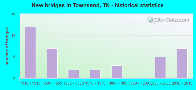
- New bridges - historical statistics
- 121940-1949
- 71950-1959
- 21960-1969
- 21970-1979
- 31980-1989
- 52000-2009
- 72010-2019

- Reconstructed bridges - Historical Statistics
- 11960-1969
- 11970-1979
- 01980-1989
- 11990-1999


- Bridge Condition - Deck
- 9.5%Very good
- 81.0%Good
- 4.8%Satisfactory
- 4.8%Fair

- Bridge Condition - Superstructure
- 14.8%Very good
- 66.7%Good
- 18.5%Satisfactory

- Bridge Condition - Substructure
- 14.8%Very good
- 66.7%Good
- 11.1%Satisfactory
- 7.4%Fair

- Bridge Condition - Channel
- 7.4%Very good
- 48.1%Good
- 33.3%Satisfactory
- 7.4%Fair
- 3.7%Poor

- Bridge Condition - Culverts
- 40.0%Good
- 60.0%Satisfactory
Find on map >> Show street view
Structure Number: 5012420001, Location: 2.O M S OF TOWNSEND (Lat: 35.678400, Lng: -83.732367), Route carried "on" structure: US 321, Year Built: 1970, Status: Open, Structure Length: 0.77m (2.53ft), Average Daily Traffic: 3,802 (year 2020), Truck Traffic: 4%, Average Future Daily Traffic: 6,083 (year 2042), Design Load: HS 20, Features Intersected: BRANCH, Facility Carried by Structure: FAP 337
Minimum Vertical Clearance: 30+ m (98+ ft), Kilometerpoint: 0.161, Lanes on structure: 2, Owner: State Highway Agency, Approaching Roadway Width: 9.4m (30.8ft), Skew: 4 degrees, Material/Design: Concrete continuous, Design/Construction: Culvert, Number Of Spans In Main Unit: 2, Length of Maximum Span: 3.4m (11.2ft)
Condition: Channel: Good, Culverts: Good, Operating Rating: 54.0 metric tons, Method Used To Determine Operating Rating: Field evaluation and documented engineering judgment, Inventory Rating: 32.4 metric tons, Method Used To Determine Inventory Rating: Field evaluation and documented engineering judgment, Structural Evaluation: Better than present minimum criteria, Waterway Adequacy: Better than present minimum criteria, Approach Roadway Alignment: Equal to present desirable criteria, Designated Inspection Frequency: Every 24 months, Inspection Date: October 2021
Find on map >> Show street view
Structure Number: 50A4240001, Location: 1.5 M. W. TOWNSEND. (Lat: 35.668450, Lng: -83.782667), Route carried "on" structure: County highway 424, Year Built: 1959, Status: Open, Structure Length: 0.76m (2.49ft), Average Daily Traffic: 1,490 (year 2019), Truck Traffic: 2%, Average Future Daily Traffic: 2,448 (year 2039), Design Load: HS 20, Features Intersected: SHORT CREEK
Minimum Vertical Clearance: 30+ m (98+ ft), Kilometerpoint: 17.344, Lanes on structure: 2, Owner: County Highway Agency, Approaching Roadway Width: 6.4m (21.0ft), Skew: 3 degrees, Material/Design: Concrete continuous, Design/Construction: Culvert, Number Of Spans In Main Unit: 2, Length of Maximum Span: 3.5m (11.5ft)
Condition: Channel: Good, Culverts: Good, Operating Rating: 45.0 metric tons, Method Used To Determine Operating Rating: Load Factor (LF), Inventory Rating: 26.1 metric tons, Method Used To Determine Inventory Rating: Load Factor (LF), Structural Evaluation: Equal to present minimum criteria, Waterway Adequacy: Better than present minimum criteria, Approach Roadway Alignment: Equal to present desirable criteria, Designated Inspection Frequency: Every 24 months, Inspection Date: November 2021
Find on map >> Show street view
Structure Number: 50A4240003, Location: 2 M. W. TOWNSEND. (Lat: 35.678233, Lng: -83.791533), Route carried "on" structure: County highway 421, Year Built: 2002, Status: Open, Structure Length: 0.93m (3.05ft), Average Daily Traffic: 1,050 (year 2022), Truck Traffic: 2%, Average Future Daily Traffic: 1,680 (year 2039), Design Load: H 20, Features Intersected: SHORT CREEK
Minimum Vertical Clearance: 30+ m (98+ ft), Kilometerpoint: 0.721, Lanes on structure: 2, Owner: County Highway Agency, Approaching Roadway Width: 7.2m (23.6ft), Skew: 3 degrees, Material/Design: Steel, Design/Construction: Stringer/Multi-beam, Number Of Spans In Main Unit: 1, Length of Maximum Span: 9.1m (29.9ft), Curb-To-Curb Width: 7.3m (24.0ft), Out-to-Out Width: 7.4m (24.3ft)
Condition: Deck: Very good, Superstructure: Very good, Substructure: Very good, Channel: Good, Operating Rating: 45.0 metric tons, Method Used To Determine Operating Rating: Load Factor (LF), Inventory Rating: 27.0 metric tons, Method Used To Determine Inventory Rating: Load Factor (LF), Structural Evaluation: Equal to present minimum criteria, Deck Geometry: Meets minimum limits, Waterway Adequacy: Better than present minimum criteria, Approach Roadway Alignment: Equal to present desirable criteria, Length Of Structure Improvement: 0.93m (3.05ft), Designated Inspection Frequency: Every 24 months, Inspection Date: November 2021, Bridge Improvement Cost: $103,000, Roadway Improvement Cost: $11,000, Total Project Cost: $155,000 ( Estimate for 2019), Deck Structure Type: Corrugated Steel, Wearing Surface/Protective System: Wearing Surface: Bituminous
Find on map >> Show street view
Structure Number: 50A5530005, Location: CAMERON RD. EXT. (Lat: 35.684450, Lng: -83.790361), Route carried "on" structure: County highway 553, Year Built: 2009, Status: Open, Structure Length: 8.72m (28.61ft), Average Daily Traffic: 1,790 (year 2022), Truck Traffic: 2%, Average Future Daily Traffic: 2,864 (year 2039), Design Load: HL 93, Features Intersected: LITTLE RIVER
Minimum Vertical Clearance: 30+ m (98+ ft), Kilometerpoint: 8.626, Lanes on structure: 2, Owner: County Highway Agency, Approaching Roadway Width: 8.5m (27.9ft), Skew: 1 degrees, Material/Design: Prestressed concrete continuous, Design/Construction: Box Beam or Girders - Single/Spread, Number Of Spans In Main Unit: 4, Length of Maximum Span: 21.8m (71.5ft), Curb-To-Curb Width: 9.5m (31.2ft), Out-to-Out Width: 10.0m (32.8ft)
Condition: Deck: Good, Superstructure: Very good, Substructure: Very good, Channel: Very good, Operating Rating: 52.5 metric tons, Method Used To Determine Operating Rating: Load and Resistance Factor Rating (LRFR) rating reported by rating factor(RF) method using HL-93 loadings, Inventory Rating: 30.5 metric tons, Method Used To Determine Inventory Rating: Load and Resistance Factor Rating (LRFR) rating reported by rating factor(RF) method using HL-93 loadings, Structural Evaluation: Better than present minimum criteria, Deck Geometry: Somewhat better than minimum adequacy, Waterway Adequacy: Equal to present desirable criteria, Approach Roadway Alignment: Equal to present desirable criteria, Designated Inspection Frequency: Every 24 months, Inspection Date: November 2021, Deck Structure Type: Concrete Cast-file-Place, Wearing Surface/Protective System: Wearing Surface: Monolithic Concrete, Deck Protection: Epoxy Coated Reinforcing
Find on map >> Show street view
Structure Number: 50A5680001, Location: 0.1M. N SR 321 @TOWNSEND. (Lat: 35.676617, Lng: -83.756367), Route carried "on" structure: City street 568, Year Built: 1964, Status: Open, Structure Length: 8.89m (29.17ft), Average Daily Traffic: 1,390 (year 2022), Truck Traffic: 2%, Average Future Daily Traffic: 2,224 (year 2039), Design Load: H 20, Features Intersected: LITTLE RIVER
Minimum Vertical Clearance: 30+ m (98+ ft), Kilometerpoint: 0.089, Lanes on structure: 2, Owner: City or Municipal Highway Agency, Approaching Roadway Width: 5.5m (18.0ft), Material/Design: Prestressed concrete, Design/Construction: Stringer/Multi-beam, Number Of Spans In Main Unit: 5, Length of Maximum Span: 17.9m (58.7ft), Curb-To-Curb Width: 7.3m (24.0ft), Out-to-Out Width: 8.7m (28.5ft)
Condition: Deck: Satisfactory, Superstructure: Good, Substructure: Good, Channel: Good, Operating Rating: 46.8 metric tons, Method Used To Determine Operating Rating: Load Factor (LF), Inventory Rating: 27.0 metric tons, Method Used To Determine Inventory Rating: Load Factor (LF), Structural Evaluation: Equal to present minimum criteria, Deck Geometry: Meets minimum limits, Waterway Adequacy: Better than present minimum criteria, Approach Roadway Alignment: Equal to present desirable criteria, Length Of Structure Improvement: 8.89m (29.17ft), Designated Inspection Frequency: Every 24 months, Inspection Date: November 2021, Bridge Improvement Cost: $529,000, Roadway Improvement Cost: $53,000, Total Project Cost: $794,000 ( Estimate for 2019), Deck Structure Type: Concrete Cast-file-Place, Wearing Surface/Protective System: Wearing Surface: Monolithic Concrete
Find on map >> Show street view
Structure Number: 50A5810001, Location: 5.5 M. SE. WALLAND. (Lat: 35.670467, Lng: -83.717367), Route carried "on" structure: County highway 581, Year Built: 2011, Status: Open, Structure Length: 3.81m (12.50ft), Average Daily Traffic: 200 (year 2022), Truck Traffic: 2%, Average Future Daily Traffic: 320 (year 2039), Design Load: HL 93, Features Intersected: LITTLE RIVER
Minimum Vertical Clearance: 30+ m (98+ ft), Kilometerpoint: 0.013, Lanes on structure: 2, Owner: County Highway Agency, Approaching Roadway Width: 6.1m (20.0ft), Material/Design: Steel, Design/Construction: Stringer/Multi-beam, Number Of Spans In Main Unit: 1, Length of Maximum Span: 38.1m (125.0ft), Curb-To-Curb Width: 7.9m (25.9ft), Out-to-Out Width: 8.6m (28.2ft)
Condition: Deck: Very good, Superstructure: Very good, Substructure: Very good, Channel: Very good, Operating Rating: 38.6 metric tons, Method Used To Determine Operating Rating: Load and Resistance Factor Rating (LRFR) rating reported by rating factor(RF) method using HL-93 loadings, Inventory Rating: 29.8 metric tons, Method Used To Determine Inventory Rating: Load and Resistance Factor Rating (LRFR) rating reported by rating factor(RF) method using HL-93 loadings, Structural Evaluation: Better than present minimum criteria, Deck Geometry: Somewhat better than minimum adequacy, Waterway Adequacy: Equal to present desirable criteria, Approach Roadway Alignment: Equal to present desirable criteria, Designated Inspection Frequency: Every 24 months, Inspection Date: November 2021, Deck Structure Type: Concrete Cast-file-Place, Wearing Surface/Protective System: Wearing Surface: Monolithic Concrete, Deck Protection: Epoxy Coated Reinforcing
Find on map >> Show street view
Structure Number: 5S24220001, Location: 4.0 M SW OF TOWNSAND (Lat: 35.680400, Lng: -83.732783), Route carried "on" structure: US 321, Year Built: 1948, Status: Posted for load, Structure Length: 7.43m (24.38ft), Average Daily Traffic: 6,354 (year 2020), Truck Traffic: 11%, Average Future Daily Traffic: 10,166 (year 2042), Design Load: H 15, Features Intersected: LITTLE RIVER, Facility Carried by Structure: FAP 73
Minimum Vertical Clearance: 30+ m (98+ ft), Kilometerpoint: 48.248, Lanes on structure: 2, Base Highway Network: Yes, Owner: State Highway Agency, Approaching Roadway Width: 6.4m (21.0ft), Material/Design: Concrete, Design/Construction: Tee Beam, Number Of Spans In Main Unit: 4, Length of Maximum Span: 16.3m (53.5ft), Curb-To-Curb Width: 6.8m (22.3ft), Out-to-Out Width: 8.8m (28.9ft)
Condition: Deck: Fair, Superstructure: Satisfactory, Substructure: Satisfactory, Channel: Good, Operating Rating: 25.2 metric tons, Method Used To Determine Operating Rating: Load Factor (LF), Inventory Rating: 20.7 metric tons, Method Used To Determine Inventory Rating: Load Factor (LF), Structural Evaluation: Somewhat better than minimum adequacy, Deck Geometry: High priority of replacement, Waterway Adequacy: Better than present minimum criteria, Approach Roadway Alignment: Better than present minimum criteria, Bridge Posting: Required (Relationship of Operating Rating to Maximum Legal Load: 0.1 - 9.9% below), Length Of Structure Improvement: 7.43m (24.38ft), Designated Inspection Frequency: Every 24 months, Inspection Date: October 2021, Bridge Improvement Cost: $933,000, Roadway Improvement Cost: $94,000, Total Project Cost: $1,400,000 ( Estimate for 2022), Deck Structure Type: Concrete Cast-file-Place, Wearing Surface/Protective System: Wearing Surface: Monolithic Concrete
Find on map >> Show street view
Structure Number: 5S24220003, Location: 1.7M S OF NPS (Lat: 35.690633, Lng: -83.707533), Route carried "on" structure: US 321, Year Built: 1948, Status: Open, Structure Length: 0.73m (2.40ft), Average Daily Traffic: 6,354 (year 2020), Truck Traffic: 11%, Average Future Daily Traffic: 10,166 (year 2042), Design Load: H 15, Features Intersected: BRANCH, Facility Carried by Structure: FAP 73
Minimum Vertical Clearance: 30+ m (98+ ft), Kilometerpoint: 51.129, Lanes on structure: 2, Base Highway Network: Yes, Owner: State Highway Agency, Approaching Roadway Width: 5.8m (19.0ft), Material/Design: Concrete continuous, Design/Construction: Culvert, Number Of Spans In Main Unit: 2, Length of Maximum Span: 3.0m (9.8ft), Curb-To-Curb Width: 7.3m (24.0ft), Out-to-Out Width: 8.6m (28.2ft)
Condition: Channel: Good, Culverts: Good, Operating Rating: 38.9 metric tons, Method Used To Determine Operating Rating: Load Factor (LF), Inventory Rating: 24.3 metric tons, Method Used To Determine Inventory Rating: Load Factor (LF), Structural Evaluation: Equal to present minimum criteria, Deck Geometry: High priority of replacement, Waterway Adequacy: Better than present minimum criteria, Approach Roadway Alignment: Equal to present desirable criteria, Length Of Structure Improvement: 0.73m (2.40ft), Designated Inspection Frequency: Every 24 months, Inspection Date: October 2021, Bridge Improvement Cost: $109,000, Roadway Improvement Cost: $11,000, Total Project Cost: $164,000 ( Estimate for 2022), Deck Structure Type: Concrete Cast-file-Place, Wearing Surface/Protective System: Wearing Surface: Bituminous
Find on map >> Show street view
Structure Number: 5SR0730027, Location: 1 M KINZEL SPRINGS (Lat: 35.686550, Lng: -83.797367), Route carried "on" structure: US 321, Year Built: 1953, Status: Open, Structure Length: 0.72m (2.36ft), Average Daily Traffic: 9,470 (year 2020), Truck Traffic: 11%, Average Future Daily Traffic: 15,152 (year 2042), Design Load: HS 20, Features Intersected: BRANCH, Facility Carried by Structure: FAP 73
Minimum Vertical Clearance: 30+ m (98+ ft), Kilometerpoint: 41.714, Lanes on structure: 3, Base Highway Network: Yes, Owner: State Highway Agency, Approaching Roadway Width: 15.5m (50.9ft), Skew: 1 degrees, Material/Design: Concrete continuous, Design/Construction: Culvert, Number Of Spans In Main Unit: 2, Length of Maximum Span: 3.1m (10.2ft)
Condition: Channel: Good, Culverts: Satisfactory, Operating Rating: 54.0 metric tons, Method Used To Determine Operating Rating: Field evaluation and documented engineering judgment, Inventory Rating: 32.4 metric tons, Method Used To Determine Inventory Rating: Field evaluation and documented engineering judgment, Structural Evaluation: Equal to present minimum criteria, Waterway Adequacy: Better than present minimum criteria, Approach Roadway Alignment: Equal to present desirable criteria, Length Of Structure Improvement: 0.72m (2.36ft), Designated Inspection Frequency: Every 24 months, Inspection Date: October 2021, Bridge Improvement Cost: $196,000, Roadway Improvement Cost: $20,000, Total Project Cost: $295,000 ( Estimate for 2022)
Find on map >> Show street view
Structure Number: 5SR0730029, Location: 3.0 M NE OF LITTLE MTN (Lat: 35.683200, Lng: -83.790533), Route carried "on" structure: US 321, Year Built: 1953, Status: Open, Structure Length: 1.49m (4.89ft), Average Daily Traffic: 9,470 (year 2020), Truck Traffic: 11%, Average Future Daily Traffic: 15,152 (year 2042), Design Load: HS 20, Features Intersected: SHORT CREEK, Facility Carried by Structure: FAP 73
Minimum Vertical Clearance: 30+ m (98+ ft), Kilometerpoint: 42.455, Lanes on structure: 2, Base Highway Network: Yes, Owner: State Highway Agency, Approaching Roadway Width: 11.3m (37.1ft), Material/Design: Concrete continuous, Design/Construction: Culvert, Number Of Spans In Main Unit: 3, Length of Maximum Span: 4.6m (15.1ft)
Condition: Channel: Good, Culverts: Good, Operating Rating: 54.0 metric tons, Method Used To Determine Operating Rating: Field evaluation and documented engineering judgment, Inventory Rating: 32.4 metric tons, Method Used To Determine Inventory Rating: Field evaluation and documented engineering judgment, Structural Evaluation: Better than present minimum criteria, Waterway Adequacy: Better than present minimum criteria, Approach Roadway Alignment: Equal to present desirable criteria, Designated Inspection Frequency: Every 24 months, Inspection Date: October 2021
Find on map >> Show street view
Structure Number: 5SR0730031, Location: 3.0 M W OF TOWNSEND (Lat: 35.678400, Lng: -83.741233), Route carried "on" structure: US 321, Year Built: 1953, Status: Open, Structure Length: 1.43m (4.69ft), Average Daily Traffic: 9,470 (year 2020), Truck Traffic: 11%, Average Future Daily Traffic: 15,152 (year 2042), Design Load: HS 20, Features Intersected: BRANCH, Facility Carried by Structure: FAP 73
Minimum Vertical Clearance: 30+ m (98+ ft), Kilometerpoint: 47.379, Lanes on structure: 4, Base Highway Network: Yes, Owner: State Highway Agency, Approaching Roadway Width: 19.5m (64.0ft), Skew: 4 degrees, Material/Design: Concrete continuous, Design/Construction: Culvert, Number Of Spans In Main Unit: 3, Length of Maximum Span: 4.6m (15.1ft)
Condition: Channel: Good, Culverts: Satisfactory, Operating Rating: 54.0 metric tons, Method Used To Determine Operating Rating: Field evaluation and documented engineering judgment, Inventory Rating: 32.4 metric tons, Method Used To Determine Inventory Rating: Field evaluation and documented engineering judgment, Structural Evaluation: Equal to present minimum criteria, Waterway Adequacy: Better than present minimum criteria, Approach Roadway Alignment: Equal to present desirable criteria, Length Of Structure Improvement: 1.43m (4.69ft), Designated Inspection Frequency: Every 24 months, Inspection Date: October 2021, Bridge Improvement Cost: $432,000, Roadway Improvement Cost: $44,000, Total Project Cost: $649,000 ( Estimate for 2022)
Find on map >> Show street view
Structure Number: 5460013P, Location: 11.3 MILES WEST FROM NPS (Lat: 35.669389, Lng: -83.662500), Route carried "on" structure: Spur Federal lands road 14, Year Built: 1950, Year Reconstructed: 1995, Status: Open, Structure Length: 2.00m (6.56ft), Average Daily Traffic: 1,410 (year 2010), Truck Traffic: 14%, Average Future Daily Traffic: 1,551 (year 2030), Design Load: H 20, Features Intersected: LITTLE RIVER, Facility Carried by Structure: LITTLE RIVER ROAD
Minimum Vertical Clearance: 30+ m (98+ ft), Kilometerpoint: 10.980, Lanes on structure: 2, Owner: National Park Service, Approaching Roadway Width: 6.7m (22.0ft), Skew: 2 degrees, Material/Design: Steel, Design/Construction: Stringer/Multi-beam, Number Of Spans In Main Unit: 1, Length of Maximum Span: 20.0m (65.6ft), Curb-To-Curb Width: 7.3m (24.0ft), Out-to-Out Width: 7.9m (25.9ft)
Condition: Deck: Good, Superstructure: Good, Substructure: Fair, Channel: Poor, Operating Rating: 39.9 metric tons, Method Used To Determine Operating Rating: Load Factor (LF), Inventory Rating: 23.6 metric tons, Method Used To Determine Inventory Rating: Load Factor (LF), Structural Evaluation: Somewhat better than minimum adequacy, Deck Geometry: Meets minimum limits, Waterway Adequacy: Equal to present desirable criteria, Approach Roadway Alignment: Equal to present desirable criteria, Designated Inspection Frequency: Every 24 months, Inspection Date: May 2020, Bridge Improvement Cost: $36,000, Roadway Improvement Cost: $4,000, Total Project Cost: $54,000 ( Estimate for 2016), Deck Structure Type: Concrete Cast-file-Place, Wearing Surface/Protective System: Wearing Surface: Bituminous
Find on map >> Show street view
Structure Number: 5460014P, Location: 0.1 MI TO NPS RTE. 14 (Lat: 35.659611, Lng: -83.708000), Route carried "on" structure: Ramp Federal lands road 16, Year Built: 1952, Status: Open, Structure Length: 2.74m (8.99ft), Average Daily Traffic: 2,706 (year 2010), Truck Traffic: 1%, Average Future Daily Traffic: 2,977 (year 2030), Features Intersected: LAUREL CREEK AND MIDDLE, Facility Carried by Structure: TOWNSEND ENTRANCE
Minimum Vertical Clearance: 30+ m (98+ ft), Kilometerpoint: 0.060, Lanes on structure: 2, Owner: National Park Service, Approaching Roadway Width: 13.4m (44.0ft), Material/Design: Concrete, Design/Construction: Arch - Deck, Number Of Spans In Main Unit: 1, Length of Maximum Span: 27.4m (89.9ft), Curb or Sidewalk Widths: Left: 0.0m, Right: 0.9m (3.0ft), Curb-To-Curb Width: 8.3m (27.2ft), Out-to-Out Width: 10.7m (35.1ft)
Condition: Superstructure: Good, Substructure: Good, Channel: Satisfactory, Operating Rating: 66.2 metric tons, Method Used To Determine Operating Rating: Load Factor (LF), Inventory Rating: 39.9 metric tons, Method Used To Determine Inventory Rating: Load Factor (LF), Structural Evaluation: Better than present minimum criteria, Deck Geometry: High priority of corrective action, Waterway Adequacy: Equal to present desirable criteria, Approach Roadway Alignment: Equal to present desirable criteria, Designated Inspection Frequency: Every 48 months, Inspection Date: May 2018, Bridge Improvement Cost: $22,000, Roadway Improvement Cost: $2,000, Total Project Cost: $33,000 ( Estimate for 2018)
Find on map >> Show street view
Structure Number: 5460015P, Location: 7.6 MI TO CADES COVE (Lat: 35.657417, Lng: -83.709833), Route carried "on" structure: Spur Federal lands road 15, Year Built: 1948, Status: Open, Structure Length: 2.13m (6.99ft), Average Daily Traffic: 3,060 (year 2010), Truck Traffic: 1%, Average Future Daily Traffic: 3,366 (year 2030), Features Intersected: MIDDLE PRONG LITTLE RIVE, Facility Carried by Structure: LAUREL CREEK ROAD
Minimum Vertical Clearance: 30+ m (98+ ft), Kilometerpoint: 0.320, Lanes on structure: 2, Owner: National Park Service, Approaching Roadway Width: 9.8m (32.2ft), Material/Design: Concrete, Design/Construction: Arch - Deck, Number Of Spans In Main Unit: 1, Length of Maximum Span: 21.3m (69.9ft), Curb-To-Curb Width: 6.1m (20.0ft), Out-to-Out Width: 10.2m (33.5ft)
Condition: Superstructure: Good, Substructure: Good, Channel: Good, Operating Rating: 29.0 metric tons, Method Used To Determine Operating Rating: Field evaluation and documented engineering judgment, Inventory Rating: 17.0 metric tons, Method Used To Determine Inventory Rating: Field evaluation and documented engineering judgment, Structural Evaluation: Meets minimum limits, Deck Geometry: High priority of replacement, Waterway Adequacy: Equal to present desirable criteria, Approach Roadway Alignment: Equal to present desirable criteria, Designated Inspection Frequency: Every 48 months, Inspection Date: May 2018, Wearing Surface/Protective System: Wearing Surface: Bituminous
Find on map >> Show street view
Structure Number: 5460017P, Location: 5.7 MI TO CADES COVE (Lat: 35.640083, Lng: -83.716028), Route carried "on" structure: Spur Federal lands road 15, Year Built: 1948, Status: Open, Structure Length: 1.47m (4.82ft), Average Daily Traffic: 3,060 (year 2010), Truck Traffic: 1%, Average Future Daily Traffic: 3,366 (year 2030), Features Intersected: WEST PRONG LITTLE RIVER, Facility Carried by Structure: LAUREL CREEK ROAD
Minimum Vertical Clearance: 30+ m (98+ ft), Kilometerpoint: 3.380, Lanes on structure: 2, Owner: National Park Service, Approaching Roadway Width: 9.8m (32.2ft), Skew: 2 degrees, Material/Design: Concrete, Design/Construction: Arch - Deck, Number Of Spans In Main Unit: 1, Length of Maximum Span: 14.7m (48.2ft), Curb-To-Curb Width: 9.8m (32.2ft), Out-to-Out Width: 11.1m (36.4ft)
Condition: Superstructure: Satisfactory, Substructure: Satisfactory, Channel: Fair, Operating Rating: 29.0 metric tons, Method Used To Determine Operating Rating: Field evaluation and documented engineering judgment, Inventory Rating: 17.0 metric tons, Method Used To Determine Inventory Rating: Field evaluation and documented engineering judgment, Structural Evaluation: Meets minimum limits, Deck Geometry: Meets minimum limits, Waterway Adequacy: Equal to present desirable criteria, Approach Roadway Alignment: Equal to present desirable criteria, Designated Inspection Frequency: Every 24 months, Inspection Date: May 2020, Bridge Improvement Cost: $47,000, Roadway Improvement Cost: $5,000, Total Project Cost: $71,000 ( Estimate for 2016)
Find on map >> Show street view
Structure Number: 5460018P, Location: 2.2 MI TO NPS RTE. 16 (Lat: 35.639750, Lng: -83.716417), Route carried "on" structure: Spur Federal lands road 15, Year Built: 1948, Status: Open, Structure Length: 1.52m (4.99ft), Average Daily Traffic: 3,060 (year 2010), Truck Traffic: 1%, Average Future Daily Traffic: 3,366 (year 2030), Design Load: H 15, Features Intersected: LAUREL CREEK, Facility Carried by Structure: LAUREL CREEK ROAD
Minimum Vertical Clearance: 30+ m (98+ ft), Kilometerpoint: 3.540, Lanes on structure: 2, Owner: National Park Service, Approaching Roadway Width: 10.4m (34.1ft), Skew: 2 degrees, Material/Design: Concrete, Design/Construction: Arch - Deck, Number Of Spans In Main Unit: 1, Length of Maximum Span: 15.2m (49.9ft), Curb-To-Curb Width: 6.6m (21.7ft), Out-to-Out Width: 11.1m (36.4ft)
Condition: Superstructure: Good, Substructure: Good, Channel: Satisfactory, Operating Rating: 28.1 metric tons, Method Used To Determine Operating Rating: Field evaluation and documented engineering judgment, Inventory Rating: 17.2 metric tons, Method Used To Determine Inventory Rating: Field evaluation and documented engineering judgment, Structural Evaluation: Meets minimum limits, Deck Geometry: High priority of replacement, Waterway Adequacy: Equal to present desirable criteria, Approach Roadway Alignment: Equal to present desirable criteria, Designated Inspection Frequency: Every 48 months, Inspection Date: May 2018
Find on map >> Show street view
Structure Number: 5460019P, Location: 2.7 MI TO NPS ROUTE 16 (Lat: 35.637556, Lng: -83.721806), Route carried "on" structure: Spur Federal lands road 15, Year Built: 1948, Status: Open, Structure Length: 1.55m (5.09ft), Average Daily Traffic: 3,060 (year 2010), Truck Traffic: 1%, Average Future Daily Traffic: 3,366 (year 2030), Design Load: H 15, Features Intersected: LAUREL CREEK, Facility Carried by Structure: LAUREL CREEK ROAD
Minimum Vertical Clearance: 30+ m (98+ ft), Kilometerpoint: 4.350, Lanes on structure: 2, Owner: National Park Service, Approaching Roadway Width: 10.4m (34.1ft), Skew: 4 degrees, Material/Design: Concrete, Design/Construction: Arch - Deck, Number Of Spans In Main Unit: 1, Length of Maximum Span: 15.5m (50.9ft), Curb-To-Curb Width: 10.4m (34.1ft), Out-to-Out Width: 11.9m (39.0ft)
Condition: Superstructure: Satisfactory, Substructure: Good, Channel: Satisfactory, Operating Rating: 29.0 metric tons, Method Used To Determine Operating Rating: Field evaluation and documented engineering judgment, Inventory Rating: 17.2 metric tons, Method Used To Determine Inventory Rating: Field evaluation and documented engineering judgment, Structural Evaluation: Meets minimum limits, Deck Geometry: Somewhat better than minimum adequacy, Waterway Adequacy: Equal to present desirable criteria, Approach Roadway Alignment: Equal to present desirable criteria, Designated Inspection Frequency: Every 24 months, Inspection Date: May 2020, Bridge Improvement Cost: $23,000, Roadway Improvement Cost: $2,000, Total Project Cost: $35,000 ( Estimate for 2018)
Find on map >> Show street view
Structure Number: 5460020P, Location: ADJACENT TO 5460-019P (Lat: 35.633306, Lng: -83.725500), Route carried "on" structure: Spur Federal lands road 15, Year Built: 1948, Status: Open, Structure Length: 1.39m (4.56ft), Average Daily Traffic: 3,060 (year 2010), Truck Traffic: 1%, Average Future Daily Traffic: 3,366 (year 2030), Features Intersected: LAUREL CREEK, Facility Carried by Structure: LAUREL CREEK ROAD
Minimum Vertical Clearance: 30+ m (98+ ft), Kilometerpoint: 5.010, Lanes on structure: 2, Owner: National Park Service, Approaching Roadway Width: 9.4m (30.8ft), Material/Design: Concrete continuous, Design/Construction: Slab, Number Of Spans In Main Unit: 2, Length of Maximum Span: 6.6m (21.7ft), Curb-To-Curb Width: 6.6m (21.7ft), Out-to-Out Width: 14.9m (48.9ft)
Condition: Deck: Good, Superstructure: Good, Substructure: Good, Channel: Satisfactory, Operating Rating: 40.8 metric tons, Method Used To Determine Operating Rating: Field evaluation and documented engineering judgment, Inventory Rating: 24.0 metric tons, Method Used To Determine Inventory Rating: Field evaluation and documented engineering judgment, Structural Evaluation: Equal to present minimum criteria, Deck Geometry: High priority of replacement, Waterway Adequacy: Equal to present desirable criteria, Approach Roadway Alignment: Equal to present minimum criteria, Designated Inspection Frequency: Every 48 months, Inspection Date: May 2018, Bridge Improvement Cost: $102,000, Roadway Improvement Cost: $10,000, Total Project Cost: $153,000 ( Estimate for 2018), Deck Structure Type: Concrete Cast-file-Place, Wearing Surface/Protective System: Wearing Surface: Bituminous
Find on map >> Show street view
Structure Number: 5460021P, Location: 3.6 MI TO N.P.S. ROUTE 16 (Lat: 35.627389, Lng: -83.726222), Route carried "on" structure: Spur Federal lands road 15, Year Built: 1948, Status: Open, Structure Length: 1.43m (4.69ft), Average Daily Traffic: 3,060 (year 2010), Truck Traffic: 1%, Average Future Daily Traffic: 3,366 (year 2030), Features Intersected: LAUREL CREEK, Facility Carried by Structure: LAUREL CREEK ROAD
Minimum Vertical Clearance: 30+ m (98+ ft), Kilometerpoint: 5.870, Lanes on structure: 2, Owner: National Park Service, Approaching Roadway Width: 9.4m (30.8ft), Skew: 3 degrees, Material/Design: Concrete, Design/Construction: Arch - Deck, Number Of Spans In Main Unit: 1, Length of Maximum Span: 14.3m (46.9ft), Curb-To-Curb Width: 9.1m (29.9ft), Out-to-Out Width: 10.3m (33.8ft)
Condition: Superstructure: Satisfactory, Substructure: Good, Channel: Satisfactory, Operating Rating: 29.9 metric tons, Method Used To Determine Operating Rating: Field evaluation and documented engineering judgment, Inventory Rating: 17.2 metric tons, Method Used To Determine Inventory Rating: Field evaluation and documented engineering judgment, Structural Evaluation: Meets minimum limits, Deck Geometry: Meets minimum limits, Waterway Adequacy: Equal to present desirable criteria, Approach Roadway Alignment: Equal to present desirable criteria, Designated Inspection Frequency: Every 24 months, Inspection Date: May 2020, Bridge Improvement Cost: $34,000, Roadway Improvement Cost: $3,000, Total Project Cost: $51,000 ( Estimate for 2018)
Find on map >> Show street view
Structure Number: 5460023P, Location: 3.4 MI TO NPS ROUTE 500 (Lat: 35.618278, Lng: -83.735556), Route carried "on" structure: Spur Federal lands road 15, Year Built: 1948, Status: Open, Structure Length: 1.17m (3.84ft), Average Daily Traffic: 3,060 (year 2010), Truck Traffic: 1%, Average Future Daily Traffic: 3,366 (year 2030), Features Intersected: LAUREL CREEK, Facility Carried by Structure: LAUREL CREEK ROAD
Minimum Vertical Clearance: 30+ m (98+ ft), Kilometerpoint: 7.340, Lanes on structure: 2, Owner: National Park Service, Approaching Roadway Width: 11.6m (38.1ft), Material/Design: Concrete, Design/Construction: Culvert, Number Of Spans In Main Unit: 2, Length of Maximum Span: 5.4m (17.7ft)
Condition: Channel: Satisfactory, Culverts: Satisfactory, Operating Rating: 40.8 metric tons, Method Used To Determine Operating Rating: Field evaluation and documented engineering judgment, Inventory Rating: 24.0 metric tons, Method Used To Determine Inventory Rating: Field evaluation and documented engineering judgment, Structural Evaluation: Equal to present minimum criteria, Waterway Adequacy: Equal to present desirable criteria, Approach Roadway Alignment: Equal to present desirable criteria, Designated Inspection Frequency: Every 24 months, Inspection Date: May 2020, Bridge Improvement Cost: $2,000, Total Project Cost: $3,000 ( Estimate for 2016)
Find on map >> Show street view
Structure Number: 5460024P, Location: 3.0 MI TO N.P.S. ROUTE 50 (Lat: 35.615972, Lng: -83.741278), Route carried "on" structure: Spur Federal lands road 15, Year Built: 1948, Status: Open, Structure Length: 1.22m (4.00ft), Average Daily Traffic: 3,060 (year 2010), Truck Traffic: 1%, Average Future Daily Traffic: 3,366 (year 2030), Features Intersected: LAUREL CREEK, Facility Carried by Structure: LAUREL CREEK ROAD
Minimum Vertical Clearance: 30+ m (98+ ft), Kilometerpoint: 7.980, Lanes on structure: 2, Owner: National Park Service, Approaching Roadway Width: 9.4m (30.8ft), Material/Design: Concrete, Design/Construction: Culvert, Number Of Spans In Main Unit: 2, Length of Maximum Span: 5.5m (18.0ft), Out-to-Out Width: 8.2m (26.9ft)
Condition: Channel: Satisfactory, Culverts: Satisfactory, Operating Rating: 40.8 metric tons, Method Used To Determine Operating Rating: Field evaluation and documented engineering judgment, Inventory Rating: 24.0 metric tons, Method Used To Determine Inventory Rating: Field evaluation and documented engineering judgment, Structural Evaluation: Equal to present minimum criteria, Waterway Adequacy: Equal to present desirable criteria, Approach Roadway Alignment: Equal to present desirable criteria, Designated Inspection Frequency: Every 48 months, Inspection Date: May 2018, Bridge Improvement Cost: $73,000, Roadway Improvement Cost: $7,000, Total Project Cost: $110,000 ( Estimate for 2018)
Find on map >> Show street view
Structure Number: 5460025P, Location: 2.6 MI TO N.P.S. ROUTE 50 (Lat: 35.611500, Lng: -83.745417), Route carried "on" structure: Spur Federal lands road 15, Year Built: 1948, Status: Open, Structure Length: 0.61m (2.00ft), Average Daily Traffic: 3,060 (year 2010), Truck Traffic: 1%, Average Future Daily Traffic: 3,366 (year 2030), Features Intersected: LAUREL CREEK, Facility Carried by Structure: LAUREL CREEK ROAD
Minimum Vertical Clearance: 30+ m (98+ ft), Kilometerpoint: 8.640, Lanes on structure: 2, Owner: National Park Service, Approaching Roadway Width: 6.1m (20.0ft), Material/Design: Concrete, Design/Construction: Culvert, Number Of Spans In Main Unit: 1, Length of Maximum Span: 6.1m (20.0ft)
Condition: Channel: Fair, Culverts: Satisfactory, Operating Rating: 40.8 metric tons, Method Used To Determine Operating Rating: Field evaluation and documented engineering judgment, Inventory Rating: 24.0 metric tons, Method Used To Determine Inventory Rating: Field evaluation and documented engineering judgment, Structural Evaluation: Equal to present minimum criteria, Waterway Adequacy: Better than present minimum criteria, Approach Roadway Alignment: Equal to present desirable criteria, Designated Inspection Frequency: Every 24 months, Inspection Date: May 2020, Bridge Improvement Cost: $95,000, Roadway Improvement Cost: $10,000, Total Project Cost: $143,000 ( Estimate for 2018)
Find on map >> Show street view
Structure Number: 5460071P, Location: 0.5 MILE TO ROUTE 15 (Lat: 35.653389, Lng: -83.701111), Route carried "on" structure: Spur Federal lands road 128, Year Built: 1984, Status: Open, Structure Length: 3.28m (10.76ft), Average Daily Traffic: 100 (year 2010), Truck Traffic: 1%, Average Future Daily Traffic: 110 (year 2030), Design Load: H 15, Features Intersected: MIDDLE PRONG LITTLE RIVE, Facility Carried by Structure: TREMONT ROAD
Minimum Vertical Clearance: 30+ m (98+ ft), Kilometerpoint: 1.060, Lanes on structure: 2, Owner: National Park Service, Approaching Roadway Width: 7.3m (24.0ft), Skew: 2 degrees, Material/Design: Concrete, Design/Construction: Tee Beam, Number Of Spans In Main Unit: 3, Length of Maximum Span: 21.2m (69.6ft), Curb-To-Curb Width: 7.3m (24.0ft), Out-to-Out Width: 8.7m (28.5ft)
Condition: Deck: Good, Superstructure: Good, Substructure: Fair, Channel: Good, Operating Rating: 30.8 metric tons, Method Used To Determine Operating Rating: Load Factor (LF), Inventory Rating: 18.1 metric tons, Method Used To Determine Inventory Rating: Load Factor (LF), Structural Evaluation: Somewhat better than minimum adequacy, Deck Geometry: Equal to present minimum criteria, Waterway Adequacy: Equal to present desirable criteria, Approach Roadway Alignment: Equal to present desirable criteria, Designated Inspection Frequency: Every 48 months, Inspection Date: May 2018, Deck Structure Type: Concrete Cast-file-Place, Wearing Surface/Protective System: Wearing Surface: Bituminous
Find on map >> Show street view
Structure Number: 5460072P, Location: 1.5 MILES TO NPS ROUTE 15 (Lat: 35.650611, Lng: -83.695833), Route carried "on" structure: Spur Federal lands road 128, Year Built: 1984, Status: Open, Structure Length: 2.50m (8.20ft), Average Daily Traffic: 100 (year 2010), Truck Traffic: 1%, Average Future Daily Traffic: 110 (year 2030), Design Load: H 15, Features Intersected: MIDDLE PRONG LITTLE RIVE, Facility Carried by Structure: TREMONT ROAD
Minimum Vertical Clearance: 30+ m (98+ ft), Kilometerpoint: 1.690, Lanes on structure: 2, Owner: National Park Service, Approaching Roadway Width: 7.3m (24.0ft), Skew: 1 degrees, Material/Design: Concrete continuous, Design/Construction: Tee Beam, Number Of Spans In Main Unit: 1, Length of Maximum Span: 23.2m (76.1ft), Curb-To-Curb Width: 7.5m (24.6ft), Out-to-Out Width: 8.7m (28.5ft)
Condition: Deck: Good, Superstructure: Satisfactory, Substructure: Good, Channel: Satisfactory, Operating Rating: 39.9 metric tons, Method Used To Determine Operating Rating: Load Factor (LF), Inventory Rating: 23.6 metric tons, Method Used To Determine Inventory Rating: Load Factor (LF), Structural Evaluation: Equal to present minimum criteria, Deck Geometry: Equal to present minimum criteria, Waterway Adequacy: Equal to present desirable criteria, Approach Roadway Alignment: Equal to present desirable criteria, Designated Inspection Frequency: Every 24 months, Inspection Date: May 2020, Bridge Improvement Cost: $19,000, Roadway Improvement Cost: $2,000, Total Project Cost: $29,000 ( Estimate for 2018), Deck Structure Type: Concrete Cast-file-Place, Wearing Surface/Protective System: Wearing Surface: Bituminous
Find on map >> Show street view
Structure Number: 5460075P, Location: 0.1 MILES TO NPS ROUTE 12 (Lat: 35.640972, Lng: -83.690278), Route carried "on" structure: Spur Federal lands road 433, Year Built: 1965, Year Reconstructed: 1982, Status: Open, Structure Length: 1.90m (6.23ft), Average Daily Traffic: 100 (year 2010), Truck Traffic: 1%, Average Future Daily Traffic: 110 (year 2030), Features Intersected: MIDDLE PRONG LITTLE RIVE, Facility Carried by Structure: GRSM INSTITUTE ENT
Minimum Vertical Clearance: 30+ m (98+ ft), Kilometerpoint: 7.050, Lanes on structure: 1, Owner: National Park Service, Approaching Roadway Width: 5.2m (17.1ft), Material/Design: Steel, Design/Construction: Stringer/Multi-beam, Number Of Spans In Main Unit: 1, Length of Maximum Span: 19.0m (62.3ft), Curb-To-Curb Width: 3.4m (11.2ft), Out-to-Out Width: 3.7m (12.1ft)
Condition: Deck: Good, Superstructure: Good, Substructure: Good, Channel: Good, Operating Rating: 57.2 metric tons, Method Used To Determine Operating Rating: Load Factor (LF), Inventory Rating: 34.5 metric tons, Method Used To Determine Inventory Rating: Load Factor (LF), Structural Evaluation: Better than present minimum criteria, Deck Geometry: High priority of corrective action, Waterway Adequacy: Equal to present desirable criteria, Approach Roadway Alignment: Equal to present desirable criteria, Designated Inspection Frequency: Every 24 months, Critical Feature Inspection Frequency: Every 24 months, Inspection Date: May 2020, Critical Feature Inspection Date: May 2020, Bridge Improvement Cost: $22,000, Roadway Improvement Cost: $2,000, Total Project Cost: $33,000 ( Estimate for 2016), Deck Structure Type: Wood or Timber
Find on map >> Show street view
Structure Number: 5460162P, Location: 3.3 MILES TO NPS ROUTE 16 (Lat: 35.668500, Lng: -83.683194), Route carried "on" structure: Spur Federal lands road 14, Year Built: 1950, Year Reconstructed: 1973, Status: Open, Structure Length: 3.07m (10.07ft), Average Daily Traffic: 2,384 (year 2010), Truck Traffic: 1%, Average Future Daily Traffic: 2,622 (year 2030), Design Load: H 20, Features Intersected: LITTLE RIVER, Facility Carried by Structure: LITTLE RIVER ROAD
Minimum Vertical Clearance: 30+ m (98+ ft), Kilometerpoint: 13.840, Lanes on structure: 2, Owner: National Park Service, Approaching Roadway Width: 6.7m (22.0ft), Material/Design: Steel, Design/Construction: Stringer/Multi-beam, Number Of Spans In Main Unit: 2, Length of Maximum Span: 15.4m (50.5ft), Curb-To-Curb Width: 7.3m (24.0ft), Out-to-Out Width: 7.9m (25.9ft)
Condition: Deck: Good, Superstructure: Good, Substructure: Satisfactory, Channel: Good, Operating Rating: 53.5 metric tons, Method Used To Determine Operating Rating: Load Factor (LF), Inventory Rating: 31.8 metric tons, Method Used To Determine Inventory Rating: Load Factor (LF), Structural Evaluation: Equal to present minimum criteria, Deck Geometry: High priority of replacement, Waterway Adequacy: Equal to present desirable criteria, Approach Roadway Alignment: High priority of corrective action, Designated Inspection Frequency: Every 24 months, Inspection Date: May 2020, Bridge Improvement Cost: $80,000, Roadway Improvement Cost: $8,000, Total Project Cost: $120,000 ( Estimate for 2016), Deck Structure Type: Concrete Cast-file-Place, Wearing Surface/Protective System: Wearing Surface: Bituminous
Find on map >> Show street view
Structure Number: 5460164P, Location: 2.8 MI TO NPS ROUTE 16. (Lat: 35.636917, Lng: -83.722556), Route carried "on" structure: Spur Federal lands road 15, Year Built: 1948, Status: Open, Structure Length: 1.19m (3.90ft), Average Daily Traffic: 3,060 (year 2010), Truck Traffic: 1%, Average Future Daily Traffic: 3,366 (year 2030), Features Intersected: LAUREL CREEK, Facility Carried by Structure: LAUREL CREEK ROAD
Minimum Vertical Clearance: 30+ m (98+ ft), Kilometerpoint: 4.430, Lanes on structure: 2, Owner: National Park Service, Approaching Roadway Width: 10.4m (34.1ft), Material/Design: Concrete, Design/Construction: Culvert, Number Of Spans In Main Unit: 2, Length of Maximum Span: 5.5m (18.0ft)
Condition: Channel: Satisfactory, Culverts: Satisfactory, Operating Rating: 40.8 metric tons, Method Used To Determine Operating Rating: Field evaluation and documented engineering judgment, Inventory Rating: 24.0 metric tons, Method Used To Determine Inventory Rating: Field evaluation and documented engineering judgment, Structural Evaluation: Equal to present minimum criteria, Waterway Adequacy: Equal to present desirable criteria, Approach Roadway Alignment: Equal to present desirable criteria, Designated Inspection Frequency: Every 48 months, Inspection Date: May 2018, Bridge Improvement Cost: $33,000, Roadway Improvement Cost: $3,000, Total Project Cost: $50,000 ( Estimate for 2018)
Find on map >> Show street view
Structure Number: 5460204P, Location: 6.2 MILES WEST OF ROUTE 3 (Lat: 35.727361, Lng: -83.735472), Route carried "on" structure: Federal lands road , Year Built: 1985, Status: Open, Structure Length: 4.83m (15.85ft), Average Daily Traffic: 1 (year 2010), Average Future Daily Traffic: 2 (year 2030), Design Load: HS 20, Features Intersected: CARR CREEK RD & CARR CRE, Facility Carried by Structure: FOOTHILLS PKWY
Minimum Vertical Clearance: 30+ m (98+ ft), Kilometerpoint: 37.500, Lanes on structure: 2, Lanes under structure: 2, Owner: National Park Service, Approaching Roadway Width: 9.1m (29.9ft), Material/Design: Prestressed concrete continuous, Design/Construction: Box Beam or Girders - Single/Spread, Number Of Spans In Main Unit: 2, Length of Maximum Span: 26.2m (86.0ft), Curb-To-Curb Width: 10.9m (35.8ft), Out-to-Out Width: 11.7m (38.4ft)
Condition: Deck: Good, Superstructure: Good, Substructure: Good, Operating Rating: 36.3 metric tons, Method Used To Determine Operating Rating: Field evaluation and documented engineering judgment, Inventory Rating: 32.7 metric tons, Method Used To Determine Inventory Rating: Field evaluation and documented engineering judgment, Structural Evaluation: Better than present minimum criteria, Deck Geometry: Superior to present desirable criteria, Underclear: Equal to present desirable criteria, Waterway Adequacy: Equal to present desirable criteria, Approach Roadway Alignment: Equal to present minimum criteria, Designated Inspection Frequency: Every 24 months, Inspection Date: May 2020, Bridge Improvement Cost: $50,000, Roadway Improvement Cost: $5,000, Total Project Cost: $75,000 ( Estimate for 2014), Deck Structure Type: Concrete Cast-file-Place, Wearing Surface/Protective System: Wearing Surface: Latex Concrete
Find on map >> Show street view
Structure Number: 5460209P, Location: 9.3 MILES EAST OF U.S. RO (Lat: 35.713417, Lng: -83.719722), Route carried "on" structure: Federal lands road , Year Built: 2001, Status: Open, Structure Length: 14.46m (47.44ft), Design Load: HL 93, Features Intersected: RAVINE, Facility Carried by Structure: FOOTHILLS PARKWAY
Minimum Vertical Clearance: 30+ m (98+ ft), Kilometerpoint: 41.840, Lanes on structure: 2, Owner: National Park Service, Approaching Roadway Width: 11.0m (36.1ft), Material/Design: Prestressed concrete continuous, Design/Construction: Segmental Box Girder, Number Of Spans In Main Unit: 3, Length of Maximum Span: 60.0m (196.9ft), Curb-To-Curb Width: 10.2m (33.5ft), Out-to-Out Width: 11.2m (36.7ft)
Condition: Deck: Good, Superstructure: Good, Substructure: Good, Operating Rating: 54.5 metric tons, Method Used To Determine Operating Rating: Load and Resistance Factor (LRFR), Inventory Rating: 32.7 metric tons, Method Used To Determine Inventory Rating: Load and Resistance Factor (LRFR), Structural Evaluation: Better than present minimum criteria, Deck Geometry: Superior to present desirable criteria, Approach Roadway Alignment: Equal to present desirable criteria, Designated Inspection Frequency: Every 24 months, Inspection Date: May 2020, Bridge Improvement Cost: $40,000, Roadway Improvement Cost: $4,000, Total Project Cost: $60,000 ( Estimate for 2014), Deck Structure Type: Concrete Cast-file-Place, Wearing Surface/Protective System: Wearing Surface: Integral Concrete
Find on map >> Show street view
Structure Number: 5460210P, Location: 9.4 MILES EAST OF U.S. RO (Lat: 35.713972, Lng: -83.717250), Route carried "on" structure: Federal lands road , Year Built: 2001, Status: Open, Structure Length: 14.65m (48.06ft), Design Load: HL 93, Features Intersected: RAVINE, Facility Carried by Structure: FOOTHILLS PARKWAY
Minimum Vertical Clearance: 30+ m (98+ ft), Kilometerpoint: 42.000, Lanes on structure: 2, Owner: National Park Service, Approaching Roadway Width: 10.6m (34.8ft), Material/Design: Prestressed concrete continuous, Design/Construction: Segmental Box Girder, Number Of Spans In Main Unit: 3, Length of Maximum Span: 61.4m (201.4ft), Curb-To-Curb Width: 10.6m (34.8ft), Out-to-Out Width: 11.6m (38.1ft)
Condition: Deck: Good, Superstructure: Good, Substructure: Very good, Operating Rating: 54.5 metric tons, Method Used To Determine Operating Rating: Load and Resistance Factor (LRFR), Inventory Rating: 32.7 metric tons, Method Used To Determine Inventory Rating: Load and Resistance Factor (LRFR), Structural Evaluation: Better than present minimum criteria, Deck Geometry: Superior to present desirable criteria, Approach Roadway Alignment: Equal to present desirable criteria, Designated Inspection Frequency: Every 24 months, Inspection Date: May 2020, Bridge Improvement Cost: $40,000, Roadway Improvement Cost: $4,000, Total Project Cost: $60,000 ( Estimate for 2014), Deck Structure Type: Concrete Cast-file-Place, Wearing Surface/Protective System: Wearing Surface: Integral Concrete
Find on map >> Show street view
Structure Number: 5460213P, Location: 9.5 MILES EAST OF U.S. RO (Lat: 35.713806, Lng: -83.714833), Route carried "on" structure: Federal lands road , Year Built: 2009, Status: Open, Structure Length: 6.40m (21.00ft), Design Load: HL 93, Features Intersected: RAVINE, Facility Carried by Structure: FOOTHILLS PARKWAY
Minimum Vertical Clearance: 30+ m (98+ ft), Kilometerpoint: 0.000, Lanes on structure: 2, Owner: National Park Service, Approaching Roadway Width: 10.3m (33.8ft), Skew: 1 degrees, Material/Design: Prestressed concrete continuous, Design/Construction: Stringer/Multi-beam, Number Of Spans In Main Unit: 3, Number Of Approach Spans: 2, Length of Maximum Span: 25.6m (84.0ft), Curb-To-Curb Width: 10.4m (34.1ft), Out-to-Out Width: 11.3m (37.1ft)
Condition: Deck: Good, Superstructure: Very good, Substructure: Good, Inventory Rating: 59.9 metric tons, Method Used To Determine Inventory Rating: Load and Resistance Factor (LRFR), Structural Evaluation: Better than present minimum criteria, Deck Geometry: Superior to present desirable criteria, Approach Roadway Alignment: Equal to present desirable criteria, Designated Inspection Frequency: Every 24 months, Inspection Date: May 2020, Bridge Improvement Cost: $40,000, Roadway Improvement Cost: $4,000, Total Project Cost: $60,000 ( Estimate for 2014), Deck Structure Type: Concrete Cast-file-Place, Wearing Surface/Protective System: Wearing Surface: Integral Concrete
Find on map >> Show street view
Structure Number: 5460214P, Location: 3.0 MILES WEST OF U.S. RO (Lat: 35.707278, Lng: -83.699944), Route carried "on" structure: Federal lands road , Year Built: 2013, Status: Open, Structure Length: 24.08m (79.00ft), Average Daily Traffic: 600 (year 2019), Average Future Daily Traffic: 720 (year 2039), Design Load: HL 93, Features Intersected: RAVINE, Facility Carried by Structure: FOOTHILLS PARKWAY
Minimum Vertical Clearance: 30+ m (98+ ft), Kilometerpoint: 43.930, Lanes on structure: 2, Owner: National Park Service, Approaching Roadway Width: 10.9m (35.8ft), Material/Design: Prestressed concrete continuous, Design/Construction: Segmental Box Girder, Number Of Spans In Main Unit: 5, Length of Maximum Span: 54.9m (180.1ft), Curb-To-Curb Width: 10.4m (34.1ft), Out-to-Out Width: 11.2m (36.7ft)
Condition: Deck: Good, Superstructure: Good, Substructure: Good, Inventory Rating: 70.8 metric tons, Method Used To Determine Inventory Rating: Load and Resistance Factor (LRFR), Structural Evaluation: Better than present minimum criteria, Deck Geometry: Equal to present minimum criteria, Approach Roadway Alignment: Equal to present desirable criteria, Designated Inspection Frequency: Every 24 months, Inspection Date: May 2020, Bridge Improvement Cost: $50,000, Roadway Improvement Cost: $5,000, Total Project Cost: $75,000 ( Estimate for 2014), Deck Structure Type: Concrete Precast Panels, Wearing Surface/Protective System: Wearing Surface: Latex Concrete
Find on map >> Show street view
Structure Number: 5460215P, Location: 10.2 miles east of juncti (Lat: 35.708550, Lng: -83.702153), Route carried "on" structure: Federal lands road , Year Built: 2018, Status: Open, Structure Length: 4.83m (15.85ft), Average Daily Traffic: 600 (year 2019), Average Future Daily Traffic: 720 (year 2039), Design Load: HL 93, Features Intersected: RAVINE, Facility Carried by Structure: FOOTHILLS PARKWAY
Minimum Vertical Clearance: 30+ m (98+ ft), Kilometerpoint: 43.770, Lanes on structure: 2, Owner: National Park Service, Approaching Roadway Width: 10.9m (35.8ft), Material/Design: Prestressed concrete, Design/Construction: Segmental Box Girder, Number Of Spans In Main Unit: 1, Length of Maximum Span: 45.7m (149.9ft), Curb-To-Curb Width: 10.4m (34.1ft), Out-to-Out Width: 11.2m (36.7ft)
Condition: Deck: Good, Superstructure: Good, Substructure: Good, Operating Rating: 44.4 metric tons, Method Used To Determine Operating Rating: Load and Resistance Factor (LRFR), Inventory Rating: 32.7 metric tons, Method Used To Determine Inventory Rating: Load and Resistance Factor (LRFR), Structural Evaluation: Better than present minimum criteria, Deck Geometry: Equal to present minimum criteria, Approach Roadway Alignment: Equal to present desirable criteria, Designated Inspection Frequency: Every 24 months, Inspection Date: May 2020, Deck Structure Type: Concrete Cast-file-Place, Wearing Surface/Protective System: Wearing Surface: Integral Concrete
Find on map >> Show street view
Structure Number: 5460216P, Location: 10.05 miles east of junct (Lat: 35.710250, Lng: -83.704808), Route carried "on" structure: Federal lands road , Year Built: 2018, Status: Open, Structure Length: 8.84m (29.00ft), Average Daily Traffic: 600 (year 2019), Average Future Daily Traffic: 720 (year 2039), Design Load: HL 93, Features Intersected: RAVINE, Facility Carried by Structure: FOOTHILLS PARKWAY
Minimum Vertical Clearance: 30+ m (98+ ft), Kilometerpoint: 43.530, Lanes on structure: 2, Owner: National Park Service, Approaching Roadway Width: 10.9m (35.8ft), Material/Design: Prestressed concrete continuous, Design/Construction: Segmental Box Girder, Number Of Spans In Main Unit: 2, Length of Maximum Span: 42.9m (140.7ft), Curb-To-Curb Width: 10.4m (34.1ft), Out-to-Out Width: 11.2m (36.7ft)
Condition: Deck: Good, Superstructure: Good, Substructure: Good, Operating Rating: 54.5 metric tons, Method Used To Determine Operating Rating: Load and Resistance Factor (LRFR), Inventory Rating: 32.7 metric tons, Method Used To Determine Inventory Rating: Load and Resistance Factor (LRFR), Structural Evaluation: Better than present minimum criteria, Deck Geometry: Equal to present minimum criteria, Approach Roadway Alignment: Equal to present desirable criteria, Designated Inspection Frequency: Every 24 months, Inspection Date: May 2020, Deck Structure Type: Concrete Cast-file-Place, Wearing Surface/Protective System: Wearing Surface: Integral Concrete
Find on map >> Show street view
Structure Number: 5460217P, Location: 9.9 miles east of junctio (Lat: 35.711208, Lng: -83.706439), Route carried "on" structure: Federal lands road , Year Built: 2018, Status: Open, Structure Length: 10.26m (33.66ft), Average Daily Traffic: 600 (year 2019), Average Future Daily Traffic: 720 (year 2039), Design Load: HL 93, Features Intersected: RAVINE, Facility Carried by Structure: FOOTHILLS PARKWAY
Minimum Vertical Clearance: 30+ m (98+ ft), Kilometerpoint: 43.290, Lanes on structure: 2, Owner: National Park Service, Approaching Roadway Width: 10.9m (35.8ft), Material/Design: Prestressed concrete continuous, Design/Construction: Segmental Box Girder, Number Of Spans In Main Unit: 2, Length of Maximum Span: 50.0m (164.0ft), Curb-To-Curb Width: 10.4m (34.1ft), Out-to-Out Width: 11.2m (36.7ft)
Condition: Deck: Good, Superstructure: Good, Substructure: Good, Operating Rating: 54.5 metric tons, Method Used To Determine Operating Rating: Load and Resistance Factor (LRFR), Inventory Rating: 32.7 metric tons, Method Used To Determine Inventory Rating: Load and Resistance Factor (LRFR), Structural Evaluation: Better than present minimum criteria, Deck Geometry: Equal to present minimum criteria, Approach Roadway Alignment: Equal to present desirable criteria, Designated Inspection Frequency: Every 24 months, Inspection Date: May 2020, Deck Structure Type: Concrete Cast-file-Place, Wearing Surface/Protective System: Wearing Surface: Integral Concrete
Find on map >> Show street view
Structure Number: 5460218P, Location: 9.8 miles east of junctio (Lat: 35.711667, Lng: -83.707408), Route carried "on" structure: Federal lands road , Year Built: 2018, Status: Open, Structure Length: 6.55m (21.49ft), Average Daily Traffic: 600 (year 2019), Average Future Daily Traffic: 720 (year 2039), Design Load: HL 93, Features Intersected: RAVINE, Facility Carried by Structure: FOOTHILLS PARKWAY
Minimum Vertical Clearance: 30+ m (98+ ft), Kilometerpoint: 43.130, Lanes on structure: 2, Owner: National Park Service, Approaching Roadway Width: 10.9m (35.8ft), Material/Design: Prestressed concrete, Design/Construction: Segmental Box Girder, Number Of Spans In Main Unit: 1, Length of Maximum Span: 62.9m (206.4ft), Curb-To-Curb Width: 10.4m (34.1ft), Out-to-Out Width: 11.2m (36.7ft)
Condition: Deck: Good, Superstructure: Good, Substructure: Good, Operating Rating: 54.5 metric tons, Method Used To Determine Operating Rating: Load and Resistance Factor (LRFR), Inventory Rating: 32.7 metric tons, Method Used To Determine Inventory Rating: Load and Resistance Factor (LRFR), Structural Evaluation: Better than present minimum criteria, Deck Geometry: Equal to present minimum criteria, Approach Roadway Alignment: Equal to present desirable criteria, Designated Inspection Frequency: Every 24 months, Inspection Date: May 2020, Deck Structure Type: Concrete Cast-file-Place, Wearing Surface/Protective System: Wearing Surface: Integral Concrete
Find on map >> Show street view
Structure Number: 5460219P, Location: 9.7 miles east of junctio (Lat: 35.711864, Lng: -83.709333), Route carried "on" structure: Federal lands road , Year Built: 2018, Status: Open, Structure Length: 6.55m (21.49ft), Average Daily Traffic: 600 (year 2019), Average Future Daily Traffic: 720 (year 2039), Design Load: HL 93, Features Intersected: RAVINE, Facility Carried by Structure: FOOTHILLS PARKWAY
Minimum Vertical Clearance: 30+ m (98+ ft), Kilometerpoint: 42.970, Lanes on structure: 2, Owner: National Park Service, Approaching Roadway Width: 10.9m (35.8ft), Material/Design: Prestressed concrete, Design/Construction: Segmental Box Girder, Number Of Spans In Main Unit: 1, Length of Maximum Span: 62.9m (206.4ft), Curb-To-Curb Width: 10.4m (34.1ft), Out-to-Out Width: 11.2m (36.7ft)
Condition: Deck: Good, Superstructure: Good, Substructure: Good, Operating Rating: 54.5 metric tons, Method Used To Determine Operating Rating: Load and Resistance Factor (LRFR), Inventory Rating: 32.7 metric tons, Method Used To Determine Inventory Rating: Load and Resistance Factor (LRFR), Structural Evaluation: Better than present minimum criteria, Deck Geometry: Equal to present minimum criteria, Approach Roadway Alignment: Equal to present desirable criteria, Designated Inspection Frequency: Every 24 months, Inspection Date: May 2020, Deck Structure Type: Concrete Cast-file-Place, Wearing Surface/Protective System: Wearing Surface: Integral Concrete
Find on map >> Show street view
Structure Number: 50A8200009, Location: 1 M. W OF CO. LINE (Lat: 35.727667, Lng: -83.735617), Route carried "under" structure: County highway 568, Year Built: 1970, Structure Length: 0. m, Average Daily Traffic: 2,540 (year 2022), Truck Traffic: 2%, Features Intersected: FOOTHILLS PARKWAY
Minimum Vertical Clearance: 6.13m (20.11ft), Kilometerpoint: 8.042, Lanes on structure: 2, Lanes under structure: 2, Material/Design: Concrete continuous, Design/Construction: Box Beam or Girders - Multiple, Length of Maximum Span: 9.0m (29.5ft)