Bridge Statistics for Tracy, Missouri (MO)
Condition, Traffic, Stress, Structural Evaluation, Project Costs
- National Bridge Inventory (NBI) Statistics
- 11Number of bridges
- 194ft / 58.9mTotal length
- $3,278,000Total costs
- 141,126Total average daily traffic
- 30,961Total average daily truck traffic
- National Bridge Inventory (NBI) Registered Bridges for Tracy
- No street view available for this location
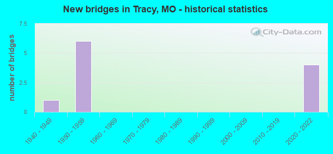
- New bridges - historical statistics
- 11940-1949
- 61950-1959
- 42020-2022

- Reconstructed bridges - Historical Statistics
- 31980-1989
- 01990-1999
- 12000-2009


- Bridge Condition - Deck
- 28.6%Excellent
- 42.9%Good
- 14.3%Fair
- 14.3%Poor

- Bridge Condition - Superstructure
- 28.6%Excellent
- 28.6%Good
- 14.3%Satisfactory
- 14.3%Fair
- 14.3%Poor

- Bridge Condition - Substructure
- 28.6%Excellent
- 42.9%Satisfactory
- 28.6%Fair

- Bridge Condition - Channel
- 33.3%Very good
- 50.0%Satisfactory
- 16.7%Fair
Find on map >> Show street view
Structure Number: 164, Location: S 25 T 53 N R 35 W (Lat: 39.379742, Lng: -94.783819), Route carried "on" structure: Interstate 29, Year Built: 1959, Year Reconstructed: 2007, Status: Open, Structure Length: 12.28m (40.29ft), Average Daily Traffic: 22,348 (year 2021), Truck Traffic: 19%, Average Future Daily Traffic: 45,813 (year 2041), Design Load: HS 20, Features Intersected: PLATTE RVR OVRFL
Minimum Vertical Clearance: 30+ m (98+ ft), Kilometerpoint: 40.263, Lanes on structure: 2, Base Highway Network: Yes, Owner: State Highway Agency, Approaching Roadway Width: 11.6m (38.1ft), Material/Design: Steel continuous, Design/Construction: Stringer/Multi-beam, Number Of Spans In Main Unit: 6, Number Of Approach Spans: 2, Length of Maximum Span: 18.3m (60.0ft), Curb or Sidewalk Widths: Left: 0.2m (0.7ft), Right: 0.2m (0.7ft), Curb-To-Curb Width: 9.4m (30.8ft), Out-to-Out Width: 10.2m (33.5ft)
Condition: Deck: Good, Superstructure: Good, Substructure: Fair, Channel: Fair, Operating Rating: 74.7 metric tons, Method Used To Determine Operating Rating: Load Factor (LF), Inventory Rating: 45.0 metric tons, Method Used To Determine Inventory Rating: Load Factor (LF), Structural Evaluation: Somewhat better than minimum adequacy, Deck Geometry: Meets minimum limits, Waterway Adequacy: Equal to present desirable criteria, Approach Roadway Alignment: Equal to present desirable criteria, Designated Inspection Frequency: Every 24 months, Inspection Date: October 2020, Deck Structure Type: Concrete Cast-file-Place, Wearing Surface/Protective System: Wearing Surface: Monolithic Concrete, Deck Protection: Epoxy Coated Reinforcing
Find on map >> Show street view
Structure Number: 165, Location: S 25 T 53 N R 35 W (Lat: 39.377744, Lng: -94.780408), Route carried "on" structure: Interstate 29, Year Built: 1959, Year Reconstructed: 1985, Status: Posted for load, Structure Length: 21.46m (70.41ft), Average Daily Traffic: 22,348 (year 2021), Truck Traffic: 19%, Average Future Daily Traffic: 45,813 (year 2041), Design Load: HS 20, Features Intersected: PLATTE RVR
Minimum Vertical Clearance: 30+ m (98+ ft), Kilometerpoint: 39.849, Lanes on structure: 2, Base Highway Network: Yes, Owner: State Highway Agency, Approaching Roadway Width: 11.6m (38.1ft), Material/Design: Steel continuous, Design/Construction: Stringer/Multi-beam, Number Of Spans In Main Unit: 3, Number Of Approach Spans: 7, Length of Maximum Span: 35.1m (115.2ft), Curb or Sidewalk Widths: Left: 0.2m (0.7ft), Right: 0.2m (0.7ft), Curb-To-Curb Width: 9.4m (30.8ft), Out-to-Out Width: 10.2m (33.5ft)
Condition: Deck: Poor, Superstructure: Satisfactory, Substructure: Fair, Channel: Satisfactory, Operating Rating: 50.4 metric tons, Method Used To Determine Operating Rating: Load Factor (LF), Inventory Rating: 29.7 metric tons, Method Used To Determine Inventory Rating: Load Factor (LF), Structural Evaluation: Somewhat better than minimum adequacy, Deck Geometry: Meets minimum limits, Waterway Adequacy: Equal to present desirable criteria, Approach Roadway Alignment: Equal to present desirable criteria, Length Of Structure Improvement: 2.18m (7.15ft), Designated Inspection Frequency: Every 24 months, Inspection Date: July 2020, Bridge Improvement Cost: $1,779,000, Roadway Improvement Cost: $178,000, Total Project Cost: $2,669,000 ( Estimate for 2022), Deck Structure Type: Concrete Cast-file-Place, Wearing Surface/Protective System: Wearing Surface: Low Slump Concrete
Find on map >> Show street view
Structure Number: 16967, Location: S 13 T 53 N R 35 W (Lat: 39.401292, Lng: -94.774228), Route carried "on" structure: County highway 138, Year Built: 1950, Status: Posted for load, Structure Length: 0.91m (2.99ft), Average Daily Traffic: 250 (year 2020), Truck Traffic: 10%, Average Future Daily Traffic: 463 (year 2040), Features Intersected: SMALL CR, Facility Carried by Structure: SHARP STATION-WEST
Minimum Vertical Clearance: 30+ m (98+ ft), Kilometerpoint: 0.966, Lanes on structure: 2, Owner: County Highway Agency, Approaching Roadway Width: 6.4m (21.0ft), Material/Design: Steel, Design/Construction: Stringer/Multi-beam, Number Of Spans In Main Unit: 1, Length of Maximum Span: 8.8m (28.9ft), Curb-To-Curb Width: 7.8m (25.6ft), Out-to-Out Width: 8.0m (26.2ft)
Condition: Deck: Fair, Superstructure: Poor, Substructure: Satisfactory, Channel: Satisfactory, Operating Rating: 12.6 metric tons, Method Used To Determine Operating Rating: Load Factor (LF), Inventory Rating: 8.1 metric tons, Method Used To Determine Inventory Rating: Load Factor (LF), Structural Evaluation: High priority of replacement, Deck Geometry: Somewhat better than minimum adequacy, Waterway Adequacy: Better than present minimum criteria, Approach Roadway Alignment: Equal to present minimum criteria, Bridge Posting: Required (Relationship of Operating Rating to Maximum Legal Load: > 39.9% below), Length Of Structure Improvement: 0.16m (0.52ft), Designated Inspection Frequency: Every 24 months, Inspection Date: April 2020, Bridge Improvement Cost: $115,000, Roadway Improvement Cost: $12,000, Total Project Cost: $173,000 ( Estimate for 2022), Deck Structure Type: Concrete Cast-file-Place, Wearing Surface/Protective System: Wearing Surface: Gravel
Find on map >> Show street view
Structure Number: 17239, Location: S 10 T 53 N R 35 W (Lat: 39.418817, Lng: -94.819561), Route carried "on" structure: County highway 146, Year Built: 1940, Year Reconstructed: 1987, Status: Posted for load, Structure Length: 3.14m (10.30ft), Average Daily Traffic: 225 (year 2020), Truck Traffic: 10%, Average Future Daily Traffic: 416 (year 2040), Features Intersected: BEE CR, Facility Carried by Structure: BEE CREEK BLVD
Minimum Vertical Clearance: 30+ m (98+ ft), Kilometerpoint: 3.541, Lanes on structure: 2, Owner: County Highway Agency, Approaching Roadway Width: 7.0m (23.0ft), Material/Design: Steel, Design/Construction: Truss - Thru, Number Of Spans In Main Unit: 1, Length of Maximum Span: 30.5m (100.1ft), Curb-To-Curb Width: 6.1m (20.0ft), Out-to-Out Width: 6.1m (20.0ft)
Condition: Deck: Good, Superstructure: Fair, Substructure: Satisfactory, Channel: Satisfactory, Operating Rating: 24.3 metric tons, Method Used To Determine Operating Rating: Allowable Stress (AS), Inventory Rating: 9.0 metric tons, Method Used To Determine Inventory Rating: Allowable Stress (AS), Structural Evaluation: High priority of replacement, Deck Geometry: Meets minimum limits, Waterway Adequacy: Better than present minimum criteria, Approach Roadway Alignment: Equal to present minimum criteria, Bridge Posting: Required (Relationship of Operating Rating to Maximum Legal Load: 0.1 - 9.9% below), Length Of Structure Improvement: 0.40m (1.31ft), Designated Inspection Frequency: Every 24 months, Critical Feature Inspection Frequency: Every 24 months, Inspection Date: April 2020, Critical Feature Inspection Date: April 2020, Bridge Improvement Cost: $291,000, Roadway Improvement Cost: $29,000, Total Project Cost: $436,000 ( Estimate for 2022), Deck Structure Type: Concrete Cast-file-Place, Wearing Surface/Protective System: Wearing Surface: Monolithic Concrete
Find on map >> Show street view
Structure Number: 36348, Location: S 23 T 53 N R 35 W (Lat: 39.385500, Lng: -94.789361), Route carried "on" structure: State highway 273, Year Built: 2020, Status: Open, Structure Length: 4.43m (14.53ft), Average Daily Traffic: 4,685 (year 2021), Truck Traffic: 6%, Average Future Daily Traffic: 8,902 (year 2041), Features Intersected: IS 29
Minimum Vertical Clearance: 30+ m (98+ ft), Kilometerpoint: 38.113, Lanes on structure: 2, Lanes under structure: 4, Owner: State Highway Agency, Approaching Roadway Width: 15.2m (49.9ft), Material/Design: Prestressed concrete continuous, Design/Construction: Stringer/Multi-beam, Number Of Spans In Main Unit: 2, Length of Maximum Span: 21.6m (70.9ft), Curb-To-Curb Width: 15.2m (49.9ft), Out-to-Out Width: 16.1m (52.8ft)
Condition: Deck: Excellent, Superstructure: Excellent, Substructure: Excellent, Operating Rating: 80.1 metric tons, Method Used To Determine Operating Rating: Load Factor (LF), Inventory Rating: 32.4 metric tons, Method Used To Determine Inventory Rating: Load Factor (LF), Structural Evaluation: Equal to present desirable criteria, Deck Geometry: Superior to present desirable criteria, Underclear: Meets minimum limits, Approach Roadway Alignment: Equal to present desirable criteria, Designated Inspection Frequency: Every 24 months, Inspection Date: March 2020, Deck Structure Type: Concrete Cast-file-Place, Wearing Surface/Protective System: Wearing Surface: Monolithic Concrete, Deck Protection: Epoxy Coated Reinforcing
Find on map >> Show street view
Structure Number: 36523, Location: S 10 T 53 N R 35 W (Lat: 39.418889, Lng: -94.819444), Route carried "on" structure: County highway 146, Year Built: 2020, Status: Not yet open, Structure Length: 4.40m (14.44ft), Average Daily Traffic: 225 (year 2021), Truck Traffic: 10%, Average Future Daily Traffic: 416 (year 2041), Design Load: HS 20, Features Intersected: BEE CR, Facility Carried by Structure: BEE CREEK BLVD
Minimum Vertical Clearance: 30+ m (98+ ft), Kilometerpoint: 3.541, Lanes on structure: 2, Owner: County Highway Agency, Approaching Roadway Width: 7.3m (24.0ft), Skew: 1 degrees, Material/Design: Prestressed concrete continuous, Design/Construction: Stringer/Multi-beam, Number Of Spans In Main Unit: 2, Length of Maximum Span: 25.8m (84.6ft), Curb-To-Curb Width: 7.3m (24.0ft), Out-to-Out Width: 7.5m (24.6ft)
Condition: Deck: Excellent, Superstructure: Excellent, Substructure: Excellent, Channel: Very good, Operating Rating: 66.6 metric tons, Method Used To Determine Operating Rating: Load Factor (LF), Inventory Rating: 39.6 metric tons, Method Used To Determine Inventory Rating: Load Factor (LF), Structural Evaluation: Superior to present desirable criteria, Deck Geometry: Somewhat better than minimum adequacy, Waterway Adequacy: Superior to present desirable criteria, Approach Roadway Alignment: Equal to present minimum criteria, Designated Inspection Frequency: Every 24 months, Inspection Date: January 2021, Deck Structure Type: Concrete Precast Panels, Wearing Surface/Protective System: Wearing Surface: Monolithic Concrete, Membrane: Built-up
Find on map >> Show street view
Structure Number: 6243, Location: S 25 T 53 N R 35 W (Lat: 39.379617, Lng: -94.784014), Route carried "on" structure: Interstate 29, Year Built: 1950, Year Reconstructed: 1992, Status: Open, Structure Length: 12.28m (40.29ft), Average Daily Traffic: 17,004 (year 2021), Truck Traffic: 20%, Average Future Daily Traffic: 34,858 (year 2041), Design Load: H 20, Features Intersected: PLATTE RVR OVRFL
Minimum Vertical Clearance: 30+ m (98+ ft), Kilometerpoint: 166.791, Lanes on structure: 2, Base Highway Network: Yes, Owner: State Highway Agency, Approaching Roadway Width: 11.6m (38.1ft), Material/Design: Steel continuous, Design/Construction: Stringer/Multi-beam, Number Of Spans In Main Unit: 6, Number Of Approach Spans: 2, Length of Maximum Span: 18.3m (60.0ft), Curb-To-Curb Width: 11.6m (38.1ft), Out-to-Out Width: 12.4m (40.7ft)
Condition: Deck: Good, Superstructure: Good, Substructure: Satisfactory, Channel: Very good, Operating Rating: 63.0 metric tons, Method Used To Determine Operating Rating: Load Factor (LF), Inventory Rating: 37.8 metric tons, Method Used To Determine Inventory Rating: Load Factor (LF), Structural Evaluation: Equal to present minimum criteria, Deck Geometry: Equal to present minimum criteria, Waterway Adequacy: Equal to present minimum criteria, Approach Roadway Alignment: Equal to present desirable criteria, Designated Inspection Frequency: Every 24 months, Inspection Date: October 2020, Deck Structure Type: Concrete Cast-file-Place, Wearing Surface/Protective System: Wearing Surface: Low Slump Concrete, Membrane: Built-up
Find on map >> Show street view
Structure Number: 36348, Location: S 23 T 53 N R 35 W (Lat: 39.385500, Lng: -94.789361), Route carried "under" structure: Interstate 29, Year Built: 2020, Structure Length: 0. m, Average Daily Traffic: 22,348 (year 2021), Truck Traffic: 19%, Features Intersected: IS 29, Facility Carried by Structure: MO 273 S
Minimum Vertical Clearance: 5.08m (16.67ft), Kilometerpoint: 41.159, Lanes on structure: 2, Lanes under structure: 2, Material/Design: Prestressed concrete continuous, Design/Construction: Stringer/Multi-beam, Length of Maximum Span: 21.6m (70.9ft)
Find on map >> Show street view
Structure Number: 36348, Location: S 23 T 53 N R 35 W (Lat: 39.385500, Lng: -94.789361), Route carried "under" structure: Interstate 29, Year Built: 2020, Structure Length: 0. m, Average Daily Traffic: 17,232 (year 2021), Truck Traffic: 29%, Features Intersected: IS 29, Facility Carried by Structure: MO 273 S
Minimum Vertical Clearance: 5.19m (17.03ft), Kilometerpoint: 166.027, Lanes on structure: 2, Lanes under structure: 2, Material/Design: Prestressed concrete continuous, Design/Construction: Stringer/Multi-beam, Length of Maximum Span: 21.6m (70.9ft)
Find on map >> Show street view
Structure Number: 86, Location: S 11 T 53 N R 35 W (Lat: 39.418947, Lng: -94.789758), Route carried "under" structure: Interstate 29, Year Built: 1958, Structure Length: 0. m, Average Daily Traffic: 17,232 (year 2021), Truck Traffic: 29%, Features Intersected: IS 29, Facility Carried by Structure: NORTH AMERICAN AVE
Minimum Vertical Clearance: 4.95m (16.24ft), Kilometerpoint: 162.312, Lanes on structure: 2, Lanes under structure: 2, Material/Design: Concrete continuous, Design/Construction: Slab, Length of Maximum Span: 17.1m (56.1ft)
Find on map >> Show street view
Structure Number: 86, Location: S 11 T 53 N R 35 W (Lat: 39.418947, Lng: -94.789758), Route carried "under" structure: Interstate 29, Year Built: 1958, Structure Length: 0. m, Average Daily Traffic: 17,229 (year 2021), Truck Traffic: 26%, Features Intersected: IS 29, Facility Carried by Structure: NORTH AMERICAN AVE
Minimum Vertical Clearance: 4.95m (16.24ft), Kilometerpoint: 44.870, Lanes on structure: 2, Lanes under structure: 2, Material/Design: Concrete continuous, Design/Construction: Slab, Length of Maximum Span: 17.1m (56.1ft)