Bridge Statistics for Tremont, Illinois (IL)
Condition, Traffic, Stress, Structural Evaluation, Project Costs
- National Bridge Inventory (NBI) Statistics
- 16Number of bridges
- 167ft / 50.5mTotal length
- $666,000Total costs
- 63,350Total average daily traffic
- 8,821Total average daily truck traffic
- National Bridge Inventory (NBI) Registered Bridges for Tremont
- No street view available for this location
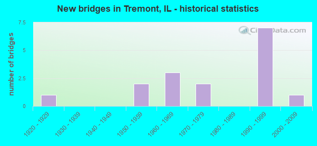
- New bridges - historical statistics
- 11920-1929
- 21950-1959
- 31960-1969
- 21970-1979
- 71990-1999
- 12000-2009


- Bridge Condition - Deck
- 8.3%Very good
- 8.3%Good
- 41.7%Satisfactory
- 16.7%Fair
- 25.0%Poor

- Bridge Condition - Superstructure
- 8.3%Very good
- 16.7%Good
- 33.3%Satisfactory
- 33.3%Fair
- 8.3%Poor

- Bridge Condition - Substructure
- 8.3%Very good
- 25.0%Good
- 50.0%Satisfactory
- 16.7%Fair

- Bridge Condition - Channel
- 20.0%Good
- 60.0%Satisfactory
- 20.0%Fair
Find on map >> Show street view
Structure Number: 90006, Location: 1 MI W OF TREMONT (Lat: 40.532967, Lng: -89.512464), Route carried "on" structure: State highway 9, Year Built: 1962, Status: Open, Structure Length: 2.83m (9.28ft), Average Daily Traffic: 7,200 (year 2021), Truck Traffic: 10%, Average Future Daily Traffic: 6,611 (year 2032), Design Load: HS 20, Features Intersected: DILLON CREEK
Minimum Vertical Clearance: 30+ m (98+ ft), Kilometerpoint: 175.092, Lanes on structure: 2, Base Highway Network: Yes, Owner: State Highway Agency, Approaching Roadway Width: 13.4m (44.0ft), Material/Design: Concrete continuous, Design/Construction: Slab, Number Of Spans In Main Unit: 3, Length of Maximum Span: 10.4m (34.1ft), Curb or Sidewalk Widths: Left: 0.6m (2.0ft), Right: 0.6m (2.0ft), Curb-To-Curb Width: 9.1m (29.9ft), Out-to-Out Width: 11.0m (36.1ft)
Condition: Deck: Poor, Superstructure: Poor, Substructure: Satisfactory, Channel: Satisfactory, Operating Rating: 48.3 metric tons, Method Used To Determine Operating Rating: Load Factor (LF) rating reported by rating factor (RF) method using MS18 loading, Inventory Rating: 28.8 metric tons, Method Used To Determine Inventory Rating: Load Factor (LF) rating reported by rating factor (RF) method using MS18 loading, Structural Evaluation: Meets minimum limits, Deck Geometry: High priority of corrective action, Waterway Adequacy: Equal to present desirable criteria, Approach Roadway Alignment: Equal to present minimum criteria, Length Of Structure Improvement: 3.69m (12.11ft), Designated Inspection Frequency: Every 12 months, Inspection Date: July 2021, Bridge Improvement Cost: $444,000, Roadway Improvement Cost: $44,000, Total Project Cost: $666,000, Deck Structure Type: Concrete Cast-file-Place, Wearing Surface/Protective System: Wearing Surface: Bituminous, Membrane: Built-up
Find on map >> Show street view
Structure Number: 900061, Location: E OF I-155 (Lat: 40.524056, Lng: -89.463461), Route carried "on" structure: State highway 9, Year Built: 1928, Year Reconstructed: 2007, Status: Open, Structure Length: 1.92m (6.30ft), Average Daily Traffic: 3,350 (year 2021), Truck Traffic: 11%, Average Future Daily Traffic: 3,601 (year 2032), Design Load: HS 20, Features Intersected: PRAIRIE CREEK
Minimum Vertical Clearance: 30+ m (98+ ft), Kilometerpoint: 179.405, Lanes on structure: 2, Base Highway Network: Yes, Owner: State Highway Agency, Approaching Roadway Width: 10.4m (34.1ft), Material/Design: Prestressed concrete, Design/Construction: Box Beam or Girders - Multiple, Number Of Spans In Main Unit: 1, Length of Maximum Span: 18.6m (61.0ft), Curb-To-Curb Width: 10.1m (33.1ft), Out-to-Out Width: 10.1m (33.1ft)
Condition: Deck: Satisfactory, Superstructure: Satisfactory, Substructure: Satisfactory, Channel: Fair, Operating Rating: 64.8 metric tons, Method Used To Determine Operating Rating: Load Factor (LF) rating reported by rating factor (RF) method using MS18 loading, Inventory Rating: 40.5 metric tons, Method Used To Determine Inventory Rating: Load Factor (LF) rating reported by rating factor (RF) method using MS18 loading, Structural Evaluation: Equal to present minimum criteria, Deck Geometry: Meets minimum limits, Waterway Adequacy: Better than present minimum criteria, Approach Roadway Alignment: Equal to present minimum criteria, Designated Inspection Frequency: Every 24 months, Inspection Date: November 2021, Deck Structure Type: Concrete Precast Panels, Wearing Surface/Protective System: Wearing Surface: Bituminous, Membrane: Built-up
Find on map >> Show street view
Structure Number: 900134, Location: 5.6 MI S OF IL 98 (Lat: 40.526253, Lng: -89.476822), Route carried "on" structure: Interstate 155, Year Built: 1990, Status: Open, Structure Length: 5.58m (18.31ft), Average Daily Traffic: 8,450 (year 2021), Truck Traffic: 17%, Average Future Daily Traffic: 9,729 (year 2032), Design Load: HS 20, Features Intersected: ILL 9
Minimum Vertical Clearance: 30+ m (98+ ft), Kilometerpoint: 41.069, Lanes on structure: 2, Lanes under structure: 4, Base Highway Network: Yes, Owner: State Highway Agency, Approaching Roadway Width: 12.8m (42.0ft), Material/Design: Steel, Design/Construction: Stringer/Multi-beam, Number Of Spans In Main Unit: 1, Number Of Approach Spans: 2, Length of Maximum Span: 37.8m (124.0ft), Curb-To-Curb Width: 12.8m (42.0ft), Out-to-Out Width: 13.8m (45.3ft)
Condition: Deck: Satisfactory, Superstructure: Satisfactory, Substructure: Good, Operating Rating: 63.2 metric tons, Method Used To Determine Operating Rating: Load Factor (LF) rating reported by rating factor (RF) method using MS18 loading, Inventory Rating: 37.9 metric tons, Method Used To Determine Inventory Rating: Load Factor (LF) rating reported by rating factor (RF) method using MS18 loading, Structural Evaluation: Equal to present minimum criteria, Deck Geometry: Equal to present desirable criteria, Underclear: Meets minimum limits, Approach Roadway Alignment: Equal to present desirable criteria, Designated Inspection Frequency: Every 24 months, Inspection Date: June 2020, Deck Structure Type: Concrete Cast-file-Place, Wearing Surface/Protective System: Deck Protection: Epoxy Coated Reinforcing
Find on map >> Show street view
Structure Number: 900135, Location: 5.6 MI S OF IL 98 (Lat: 40.526139, Lng: -89.476817), Route carried "on" structure: Interstate 155, Year Built: 1990, Status: Open, Structure Length: 5.58m (18.31ft), Average Daily Traffic: 7,050 (year 2021), Truck Traffic: 19%, Average Future Daily Traffic: 7,310 (year 2032), Design Load: HS 20, Features Intersected: ILL 9
Minimum Vertical Clearance: 30+ m (98+ ft), Kilometerpoint: 41.053, Lanes on structure: 2, Lanes under structure: 4, Base Highway Network: Yes, Owner: State Highway Agency, Approaching Roadway Width: 12.8m (42.0ft), Material/Design: Steel, Design/Construction: Stringer/Multi-beam, Number Of Spans In Main Unit: 1, Number Of Approach Spans: 2, Length of Maximum Span: 37.8m (124.0ft), Curb-To-Curb Width: 12.8m (42.0ft), Out-to-Out Width: 13.8m (45.3ft)
Condition: Deck: Satisfactory, Superstructure: Good, Substructure: Good, Operating Rating: 63.2 metric tons, Method Used To Determine Operating Rating: Load Factor (LF) rating reported by rating factor (RF) method using MS18 loading, Inventory Rating: 37.9 metric tons, Method Used To Determine Inventory Rating: Load Factor (LF) rating reported by rating factor (RF) method using MS18 loading, Structural Evaluation: Better than present minimum criteria, Deck Geometry: Equal to present desirable criteria, Underclear: Meets minimum limits, Approach Roadway Alignment: Equal to present desirable criteria, Designated Inspection Frequency: Every 24 months, Inspection Date: June 2020, Deck Structure Type: Concrete Cast-file-Place, Wearing Surface/Protective System: Deck Protection: Epoxy Coated Reinforcing
Find on map >> Show street view
Structure Number: 900136, Location: 3 MI S OF IL 9 (Lat: 40.481669, Lng: -89.472003), Route carried "on" structure: County highway , Year Built: 1992, Status: Open, Structure Length: 6.69m (21.95ft), Average Daily Traffic: 2,150 (year 2018), Truck Traffic: 12%, Average Future Daily Traffic: 1,720 (year 2032), Design Load: HS 20, Features Intersected: I-155, Facility Carried by Structure: TOWNLINE RD-CH 7
Minimum Vertical Clearance: 30+ m (98+ ft), Kilometerpoint: 5.810, Lanes on structure: 3, Lanes under structure: 4, Owner: State Highway Agency, Approaching Roadway Width: 12.2m (40.0ft), Skew: 30 degrees, Material/Design: Steel continuous, Design/Construction: Stringer/Multi-beam, Number Of Spans In Main Unit: 2, Number Of Approach Spans: 2, Length of Maximum Span: 29.1m (95.5ft), Curb-To-Curb Width: 17.7m (58.1ft), Out-to-Out Width: 19.9m (65.3ft)
Condition: Deck: Fair, Superstructure: Fair, Substructure: Satisfactory, Operating Rating: 61.2 metric tons, Method Used To Determine Operating Rating: Load Factor (LF) rating reported by rating factor (RF) method using MS18 loading, Inventory Rating: 36.6 metric tons, Method Used To Determine Inventory Rating: Load Factor (LF) rating reported by rating factor (RF) method using MS18 loading, Structural Evaluation: Somewhat better than minimum adequacy, Deck Geometry: Superior to present desirable criteria, Underclear: Somewhat better than minimum adequacy, Approach Roadway Alignment: Equal to present desirable criteria, Designated Inspection Frequency: Every 24 months, Inspection Date: January 2021, Deck Structure Type: Concrete Cast-file-Place, Wearing Surface/Protective System: Deck Protection: Epoxy Coated Reinforcing
Find on map >> Show street view
Structure Number: 903009, Location: N.CTR-4-T23NR3W (Lat: 40.482222, Lng: -89.449167), Route carried "on" structure: County highway , Year Built: 1959, Status: Open, Structure Length: 1.77m (5.81ft), Average Daily Traffic: 1,350 (year 2018), Truck Traffic: 10%, Average Future Daily Traffic: 1,236 (year 2032), Design Load: H 15, Features Intersected: PRAIRIE CREEK, Facility Carried by Structure: FAS 1481-CH 7
Minimum Vertical Clearance: 30+ m (98+ ft), Kilometerpoint: 7.725, Lanes on structure: 2, Owner: County Highway Agency, Approaching Roadway Width: 11.0m (36.1ft), Material/Design: Steel, Design/Construction: Stringer/Multi-beam, Number Of Spans In Main Unit: 1, Length of Maximum Span: 16.8m (55.1ft), Curb-To-Curb Width: 7.3m (24.0ft), Out-to-Out Width: 8.8m (28.9ft)
Condition: Deck: Poor, Superstructure: Fair, Substructure: Fair, Channel: Satisfactory, Operating Rating: 40.8 metric tons, Method Used To Determine Operating Rating: Load Factor (LF) rating reported by rating factor (RF) method using MS18 loading, Inventory Rating: 19.1 metric tons, Method Used To Determine Inventory Rating: Load Factor (LF) rating reported by rating factor (RF) method using MS18 loading, Structural Evaluation: Somewhat better than minimum adequacy, Deck Geometry: Meets minimum limits, Waterway Adequacy: Superior to present desirable criteria, Approach Roadway Alignment: Equal to present desirable criteria, Designated Inspection Frequency: Every 24 months, Inspection Date: January 2021, Deck Structure Type: Concrete Cast-file-Place, Wearing Surface/Protective System: Wearing Surface: Bituminous, Membrane: Built-up
Find on map >> Show street view
Structure Number: 903085, Location: SE-17-T24NR3W (Lat: 40.525525, Lng: -89.459753), Route carried "on" structure: County highway , Year Built: 1967, Status: Open, Structure Length: 1.77m (5.81ft), Average Daily Traffic: 800 (year 2018), Truck Traffic: 2%, Average Future Daily Traffic: 860 (year 2032), Features Intersected: PRAIRIE CREEK, Facility Carried by Structure: LAKE WINDMERE-TR10
Minimum Vertical Clearance: 30+ m (98+ ft), Kilometerpoint: 0.515, Lanes on structure: 2, Owner: Town or Township Highway Agency, Approaching Roadway Width: 8.5m (27.9ft), Material/Design: Steel, Design/Construction: Stringer/Multi-beam, Number Of Spans In Main Unit: 1, Length of Maximum Span: 17.1m (56.1ft), Curb-To-Curb Width: 7.9m (25.9ft), Out-to-Out Width: 8.6m (28.2ft)
Condition: Deck: Poor, Superstructure: Fair, Substructure: Satisfactory, Channel: Satisfactory, Operating Rating: 38.2 metric tons, Method Used To Determine Operating Rating: Allowable Stress (AS) rating reported by rating factor (RF) method using MS18 loading, Inventory Rating: 24.0 metric tons, Method Used To Determine Inventory Rating: Allowable Stress (AS) rating reported by rating factor (RF) method using MS18 loading, Structural Evaluation: Somewhat better than minimum adequacy, Deck Geometry: Somewhat better than minimum adequacy, Waterway Adequacy: Superior to present desirable criteria, Approach Roadway Alignment: Equal to present desirable criteria, Designated Inspection Frequency: Every 24 months, Inspection Date: January 2021, Deck Structure Type: Concrete Cast-file-Place, Wearing Surface/Protective System: Wearing Surface: Bituminous
Find on map >> Show street view
Structure Number: 903086, Location: NE-23-T24NR4W (Lat: 40.520908, Lng: -89.519586), Route carried "on" structure: County highway , Year Built: 1958, Status: Open, Structure Length: 1.77m (5.81ft), Average Daily Traffic: 500 (year 2018), Truck Traffic: 1%, Average Future Daily Traffic: 430 (year 2032), Features Intersected: DILLON CREEK, Facility Carried by Structure: FRANKLIN RD - TR 1
Minimum Vertical Clearance: 30+ m (98+ ft), Kilometerpoint: 1.770, Lanes on structure: 2, Owner: Town or Township Highway Agency, Approaching Roadway Width: 6.1m (20.0ft), Material/Design: Steel, Design/Construction: Stringer/Multi-beam, Number Of Spans In Main Unit: 1, Length of Maximum Span: 16.8m (55.1ft), Curb-To-Curb Width: 8.0m (26.2ft), Out-to-Out Width: 8.6m (28.2ft)
Condition: Deck: Satisfactory, Superstructure: Satisfactory, Substructure: Satisfactory, Channel: Good, Operating Rating: 33.7 metric tons, Method Used To Determine Operating Rating: Allowable Stress (AS) rating reported by rating factor (RF) method using MS18 loading, Inventory Rating: 20.4 metric tons, Method Used To Determine Inventory Rating: Allowable Stress (AS) rating reported by rating factor (RF) method using MS18 loading, Structural Evaluation: Somewhat better than minimum adequacy, Deck Geometry: Somewhat better than minimum adequacy, Waterway Adequacy: Equal to present desirable criteria, Approach Roadway Alignment: Equal to present desirable criteria, Designated Inspection Frequency: Every 24 months, Inspection Date: January 2021, Deck Structure Type: Concrete Cast-file-Place, Wearing Surface/Protective System: Wearing Surface: Bituminous
Find on map >> Show street view
Structure Number: 903093, Location: NE-34-T24NR4W (Lat: 40.495431, Lng: -89.534847), Route carried "on" structure: County highway , Year Built: 1962, Status: Open, Structure Length: 2.65m (8.69ft), Average Daily Traffic: 200 (year 2018), Truck Traffic: 1%, Average Future Daily Traffic: 269 (year 2032), Design Load: H 15, Features Intersected: DILLON CREEK, Facility Carried by Structure: RED SHALE HILL-TR1
Minimum Vertical Clearance: 30+ m (98+ ft), Kilometerpoint: 9.978, Lanes on structure: 2, Owner: Town or Township Highway Agency, Approaching Roadway Width: 6.1m (20.0ft), Material/Design: Steel continuous, Design/Construction: Stringer/Multi-beam, Number Of Spans In Main Unit: 2, Length of Maximum Span: 12.8m (42.0ft), Curb-To-Curb Width: 7.3m (24.0ft), Out-to-Out Width: 8.6m (28.2ft)
Condition: Deck: Good, Superstructure: Fair, Substructure: Satisfactory, Channel: Satisfactory, Operating Rating: 33.4 metric tons, Method Used To Determine Operating Rating: Allowable Stress (AS) rating reported by rating factor (RF) method using MS18 loading, Inventory Rating: 22.0 metric tons, Method Used To Determine Inventory Rating: Allowable Stress (AS) rating reported by rating factor (RF) method using MS18 loading, Structural Evaluation: Somewhat better than minimum adequacy, Deck Geometry: Somewhat better than minimum adequacy, Waterway Adequacy: Equal to present desirable criteria, Approach Roadway Alignment: Equal to present desirable criteria, Designated Inspection Frequency: Every 24 months, Inspection Date: January 2021, Deck Structure Type: Concrete Cast-file-Place, Wearing Surface/Protective System: Wearing Surface: Bituminous
Find on map >> Show street view
Structure Number: 90316, Location: SE-27-T24NR3W (Lat: 40.503208, Lng: -89.424417), Route carried "on" structure: County highway , Year Built: 1971, Status: Open, Structure Length: 12.50m (41.01ft), Average Daily Traffic: 150 (year 2018), Truck Traffic: 3%, Average Future Daily Traffic: 242 (year 2032), Design Load: HS 15, Features Intersected: MACKINAW R, Facility Carried by Structure: BENSON RD - TR 232
Minimum Vertical Clearance: 30+ m (98+ ft), Kilometerpoint: 1.802, Lanes on structure: 2, Owner: Town or Township Highway Agency, Approaching Roadway Width: 9.1m (29.9ft), Material/Design: Steel continuous, Design/Construction: Stringer/Multi-beam, Number Of Spans In Main Unit: 4, Length of Maximum Span: 34.7m (113.8ft), Curb-To-Curb Width: 7.9m (25.9ft), Out-to-Out Width: 8.5m (27.9ft)
Condition: Deck: Fair, Superstructure: Good, Substructure: Good, Channel: Fair, Operating Rating: 47.3 metric tons, Method Used To Determine Operating Rating: Load Factor (LF) rating reported by rating factor (RF) method using MS18 loading, Inventory Rating: 28.5 metric tons, Method Used To Determine Inventory Rating: Load Factor (LF) rating reported by rating factor (RF) method using MS18 loading, Structural Evaluation: Better than present minimum criteria, Deck Geometry: Somewhat better than minimum adequacy, Waterway Adequacy: Somewhat better than minimum adequacy, Approach Roadway Alignment: Equal to present desirable criteria, Designated Inspection Frequency: Every 24 months, Inspection Date: January 2022, Deck Structure Type: Concrete Cast-file-Place
Find on map >> Show street view
Structure Number: 903211, Location: NW-26-T24N-R4W (Lat: 40.506372, Lng: -89.530739), Route carried "on" structure: County highway , Year Built: 1992, Status: Open, Structure Length: 3.20m (10.50ft), Average Daily Traffic: 2,100 (year 2018), Truck Traffic: 4%, Average Future Daily Traffic: 2,204 (year 2032), Design Load: HS 20, Features Intersected: DILLON CREEK, Facility Carried by Structure: FAS 464 - CH 1
Minimum Vertical Clearance: 30+ m (98+ ft), Kilometerpoint: 9.318, Lanes on structure: 2, Owner: County Highway Agency, Approaching Roadway Width: 9.8m (32.2ft), Skew: 2 degrees, Material/Design: Prestressed concrete, Design/Construction: Box Beam or Girders - Multiple, Number Of Spans In Main Unit: 3, Length of Maximum Span: 11.6m (38.1ft), Curb-To-Curb Width: 9.1m (29.9ft), Out-to-Out Width: 9.1m (29.9ft)
Condition: Deck: Satisfactory, Superstructure: Satisfactory, Substructure: Fair, Channel: Satisfactory, Operating Rating: 44.1 metric tons, Method Used To Determine Operating Rating: Assigned rating based on Load Factor Design (LFD) reported by rating factor (RF) using MS18 loading, Inventory Rating: 32.4 metric tons, Method Used To Determine Inventory Rating: Assigned rating based on Load Factor Design (LFD) reported by rating factor (RF) using MS18 loading, Structural Evaluation: Somewhat better than minimum adequacy, Deck Geometry: Meets minimum limits, Waterway Adequacy: Equal to present desirable criteria, Approach Roadway Alignment: Equal to present desirable criteria, Designated Inspection Frequency: Every 24 months, Inspection Date: January 2021, Deck Structure Type: Concrete Precast Panels, Wearing Surface/Protective System: Wearing Surface: Bituminous, Membrane: Built-up
Find on map >> Show street view
Structure Number: 903238, Location: SW COR-1-T24NR4W (Lat: 40.553669, Lng: -89.508925), Route carried "on" structure: County highway , Year Built: 2005, Status: Open, Structure Length: 3.07m (10.07ft), Average Daily Traffic: 625 (year 2018), Truck Traffic: 6%, Average Future Daily Traffic: 645 (year 2032), Design Load: HS 20, Features Intersected: DILLON CREEK, Facility Carried by Structure: FAS 467-CH 5
Minimum Vertical Clearance: 30+ m (98+ ft), Kilometerpoint: 1.867, Lanes on structure: 2, Owner: County Highway Agency, Approaching Roadway Width: 6.7m (22.0ft), Material/Design: Steel continuous, Design/Construction: Stringer/Multi-beam, Number Of Spans In Main Unit: 3, Length of Maximum Span: 11.5m (37.7ft), Curb-To-Curb Width: 9.1m (29.9ft), Out-to-Out Width: 9.1m (29.9ft)
Condition: Deck: Very good, Superstructure: Very good, Substructure: Very good, Channel: Good, Operating Rating: 89.1 metric tons, Method Used To Determine Operating Rating: Load Factor (LF) rating reported by rating factor (RF) method using MS18 loading, Inventory Rating: 75.2 metric tons, Method Used To Determine Inventory Rating: Load Factor (LF) rating reported by rating factor (RF) method using MS18 loading, Structural Evaluation: Equal to present desirable criteria, Deck Geometry: Equal to present minimum criteria, Waterway Adequacy: Equal to present desirable criteria, Approach Roadway Alignment: Equal to present desirable criteria, Designated Inspection Frequency: Every 48 months, Inspection Date: January 2021, Deck Structure Type: Concrete Cast-file-Place, Wearing Surface/Protective System: Deck Protection: Epoxy Coated Reinforcing
Find on map >> Show street view
Structure Number: 905024, Location: E.CTR-29-T24NR3W (Lat: 40.503739, Lng: -89.460192), Route carried "on" structure: County highway , Year Built: 1975, Status: Open, Structure Length: 1.22m (4.00ft), Average Daily Traffic: 75 (year 2018), Truck Traffic: 1%, Average Future Daily Traffic: 108 (year 2032), Features Intersected: PRAIRIE CREEK, Facility Carried by Structure: TR 133A
Minimum Vertical Clearance: 30+ m (98+ ft), Kilometerpoint: 0.595, Lanes on structure: 2, Owner: Town or Township Highway Agency, Approaching Roadway Width: 8.5m (27.9ft), Material/Design: Concrete, Design/Construction: Culvert, Number Of Spans In Main Unit: 3, Length of Maximum Span: 3.7m (12.1ft), Curb-To-Curb Width: 8.1m (26.6ft), Out-to-Out Width: 9.3m (30.5ft)
Condition: Channel: Satisfactory, Culverts: Satisfactory, Operating Rating: 66.1 metric tons, Method Used To Determine Operating Rating: Allowable Stress (AS) rating reported by rating factor (RF) method using MS18 loading, Inventory Rating: 39.9 metric tons, Method Used To Determine Inventory Rating: Allowable Stress (AS) rating reported by rating factor (RF) method using MS18 loading, Structural Evaluation: Equal to present minimum criteria, Deck Geometry: Equal to present minimum criteria, Waterway Adequacy: Superior to present desirable criteria, Approach Roadway Alignment: Equal to present desirable criteria, Designated Inspection Frequency: Every 24 months, Inspection Date: January 2022, Deck Structure Type: Concrete Cast-file-Place
Find on map >> Show street view
Structure Number: 900134, Location: 5.6 MI S OF IL 98 (Lat: 40.526161, Lng: -89.477117), Route carried "under" structure: State highway 9, Year Built: 1990, Structure Length: 0. m, Average Daily Traffic: 9,150 (year 2021), Truck Traffic: 11%, Features Intersected: ILL 9, Facility Carried by Structure: SB I-155
Minimum Vertical Clearance: 5.03m (16.50ft), Kilometerpoint: 178.214, Lanes on structure: 2, Lanes under structure: 4, Material/Design: Steel, Design/Construction: Stringer/Multi-beam, Length of Maximum Span: 37.8m (124.0ft)
Find on map >> Show street view
Structure Number: 900135, Location: 5.6 MI S OF IL 98 (Lat: 40.526139, Lng: -89.476817), Route carried "under" structure: State highway 9, Year Built: 1990, Structure Length: 0. m, Average Daily Traffic: 6,100 (year 2021), Truck Traffic: 12%, Features Intersected: ILL 9, Facility Carried by Structure: NB I-155
Minimum Vertical Clearance: 5.05m (16.57ft), Kilometerpoint: 178.246, Lanes on structure: 2, Lanes under structure: 4, Material/Design: Steel, Design/Construction: Stringer/Multi-beam, Length of Maximum Span: 37.8m (124.0ft)
Find on map >> Show street view
Structure Number: 900136, Location: 3 MI S OF IL 9 (Lat: 40.481675, Lng: -89.471431), Route carried "under" structure: Interstate 155, Year Built: 1992, Structure Length: 0. m, Average Daily Traffic: 14,100 (year 2021), Truck Traffic: 19%, Features Intersected: I-155, Facility Carried by Structure: TOWNLINE RD-CH 7
Minimum Vertical Clearance: 4.95m (16.24ft), Kilometerpoint: 36.064, Lanes on structure: 3, Lanes under structure: 4, Material/Design: Steel continuous, Design/Construction: Stringer/Multi-beam, Length of Maximum Span: 29.1m (95.5ft)