Bridge Statistics for Tremonton, Utah (UT)
Condition, Traffic, Stress, Structural Evaluation, Project Costs
- National Bridge Inventory (NBI) Statistics
- 42Number of bridges
- 338ft / 103mTotal length
- 321,913Total average daily traffic
- 127,878Total average daily truck traffic
- National Bridge Inventory (NBI) Registered Bridges for Tremonton
- No street view available for this location
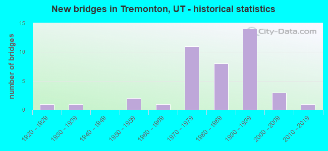
- New bridges - historical statistics
- 11920-1929
- 11930-1939
- 21950-1959
- 11960-1969
- 111970-1979
- 81980-1989
- 141990-1999
- 32000-2009
- 12010-2019
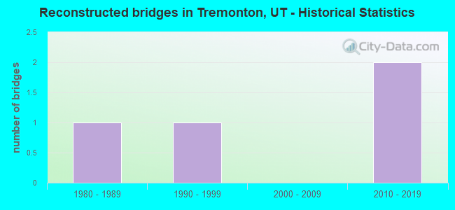
- Reconstructed bridges - Historical Statistics
- 11980-1989
- 11990-1999
- 02000-2009
- 22010-2019
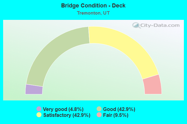
- Bridge Condition - Deck
- 4.8%Very good
- 42.9%Good
- 42.9%Satisfactory
- 9.5%Fair
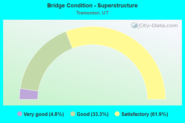
- Bridge Condition - Superstructure
- 4.8%Very good
- 33.3%Good
- 61.9%Satisfactory
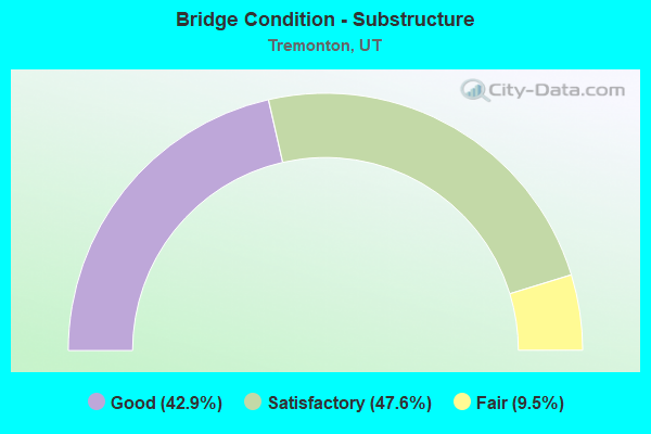
- Bridge Condition - Substructure
- 42.9%Good
- 47.6%Satisfactory
- 9.5%Fair
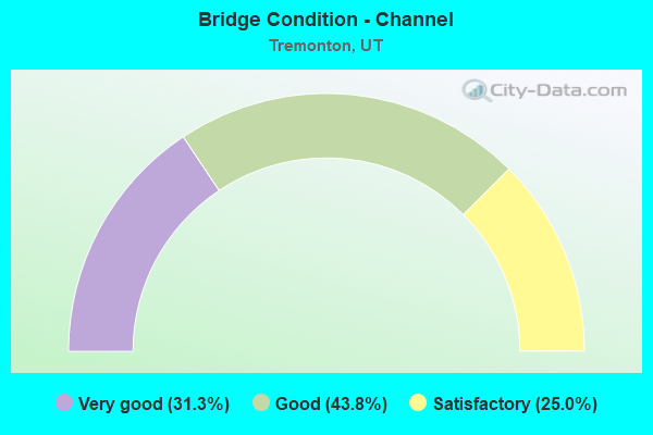
- Bridge Condition - Channel
- 31.3%Very good
- 43.8%Good
- 25.0%Satisfactory
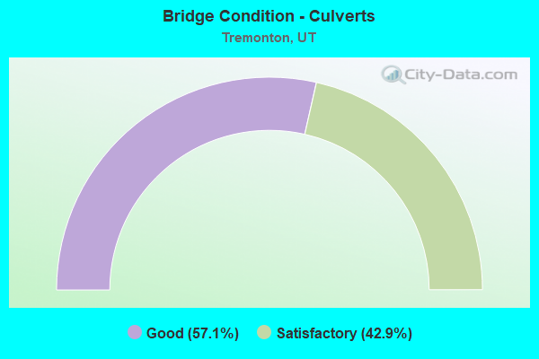
- Bridge Condition - Culverts
- 57.1%Good
- 42.9%Satisfactory
Find on map >> Show street view
Structure Number: 3008D, Location: NW SIDE OF TREMONTON (Lat: 41.725464, Lng: -112.201472), Route carried "on" structure: City street 1127, Year Built: 1950, Year Reconstructed: 2010, Status: Open, Structure Length: 0.91m (2.99ft), Average Daily Traffic: 605 (year 2020), Average Future Daily Traffic: 756 (year 2040), Design Load: H 15, Features Intersected: HIGHLINE CANAL, Facility Carried by Structure: CITY RD-TREMONTON
Minimum Vertical Clearance: 30+ m (98+ ft), Kilometerpoint: 2.322, Lanes on structure: 2, Owner: City or Municipal Highway Agency, Approaching Roadway Width: 7.2m (23.6ft), Skew: 4 degrees, Material/Design: Concrete, Design/Construction: Slab, Number Of Spans In Main Unit: 1, Length of Maximum Span: 8.5m (27.9ft), Curb-To-Curb Width: 7.2m (23.6ft), Out-to-Out Width: 9.8m (32.2ft)
Condition: Deck: Satisfactory, Superstructure: Satisfactory, Substructure: Satisfactory, Channel: Satisfactory, Operating Rating: 32.4 metric tons, Method Used To Determine Operating Rating: Load Factor (LF) rating reported by rating factor (RF) method using MS18 loading, Inventory Rating: 19.8 metric tons, Method Used To Determine Inventory Rating: Load Factor (LF) rating reported by rating factor (RF) method using MS18 loading, Structural Evaluation: Somewhat better than minimum adequacy, Deck Geometry: Meets minimum limits, Waterway Adequacy: Equal to present minimum criteria, Approach Roadway Alignment: Equal to present desirable criteria, Designated Inspection Frequency: Every 24 months, Inspection Date: November 2021, Deck Structure Type: Concrete Cast-file-Place, Wearing Surface/Protective System: Wearing Surface: Bituminous
Find on map >> Show street view
Structure Number: 3009V, Location: NW SIDE OF TREMONTON (Lat: 41.723400, Lng: -112.200800), Route carried "on" structure: City street 1125, Year Built: 1980, Status: Posted for load, Structure Length: 0.75m (2.46ft), Average Daily Traffic: 1,608 (year 2020), Average Future Daily Traffic: 2,010 (year 2040), Design Load: HS 20+Mod, Features Intersected: WEST CANAL, Facility Carried by Structure: CITY RD-TREMONTON
Minimum Vertical Clearance: 30+ m (98+ ft), Kilometerpoint: 1.382, Lanes on structure: 2, Owner: City or Municipal Highway Agency, Approaching Roadway Width: 7.6m (24.9ft), Skew: 3 degrees, Material/Design: Steel, Design/Construction: Culvert, Number Of Spans In Main Unit: 2, Length of Maximum Span: 3.0m (9.8ft)
Condition: Channel: Satisfactory, Culverts: Good, Operating Rating: 97.2 metric tons, Method Used To Determine Operating Rating: Load and Resistance Factor Rating (LRFR) rating reported by rating factor(RF) method using HL-93 loadings, Inventory Rating: 96.9 metric tons, Method Used To Determine Inventory Rating: Load and Resistance Factor Rating (LRFR) rating reported by rating factor(RF) method using HL-93 loadings, Structural Evaluation: Better than present minimum criteria, Waterway Adequacy: Better than present minimum criteria, Approach Roadway Alignment: Equal to present desirable criteria, Designated Inspection Frequency: Every 24 months, Inspection Date: November 2021
Find on map >> Show street view
Structure Number: 3042F, Location: SOUTH SIDE OF TREMONTON (Lat: 41.697375, Lng: -112.161836), Route carried "on" structure: City street 1124, Year Built: 1965, Status: Open, Structure Length: 1.52m (4.99ft), Average Daily Traffic: 281 (year 2020), Average Future Daily Traffic: 351 (year 2040), Design Load: HL 93, Features Intersected: MALAD RIVER, Facility Carried by Structure: CITY STREET
Minimum Vertical Clearance: 30+ m (98+ ft), Kilometerpoint: 1.654, Lanes on structure: 2, Owner: City or Municipal Highway Agency, Approaching Roadway Width: 8.0m (26.2ft), Material/Design: Prestressed concrete, Design/Construction: Tee Beam, Number Of Spans In Main Unit: 1, Length of Maximum Span: 14.9m (48.9ft), Curb-To-Curb Width: 8.0m (26.2ft), Out-to-Out Width: 8.6m (28.2ft)
Condition: Deck: Satisfactory, Superstructure: Satisfactory, Substructure: Satisfactory, Channel: Good, Operating Rating: 32.4 metric tons, Method Used To Determine Operating Rating: Load and Resistance Factor Rating (LRFR) rating reported by rating factor(RF) method using HL-93 loadings, Inventory Rating: 22.0 metric tons, Method Used To Determine Inventory Rating: Load and Resistance Factor Rating (LRFR) rating reported by rating factor(RF) method using HL-93 loadings, Structural Evaluation: Equal to present minimum criteria, Deck Geometry: Somewhat better than minimum adequacy, Waterway Adequacy: Equal to present minimum criteria, Approach Roadway Alignment: Equal to present desirable criteria, Designated Inspection Frequency: Every 24 months, Inspection Date: November 2021, Deck Structure Type: Concrete Precast Panels, Wearing Surface/Protective System: Wearing Surface: Bituminous
Find on map >> Show street view
Structure Number: 3043F, Location: 5200 W.10800 N. IN COUNTY (Lat: 41.705064, Lng: -112.142447), Route carried "on" structure: County highway , Year Built: 1977, Status: Open, Structure Length: 0.71m (2.33ft), Average Daily Traffic: 126 (year 2020), Average Future Daily Traffic: 153 (year 2040), Design Load: HS 20+Mod, Features Intersected: CORINNE CANAL, Facility Carried by Structure: COUNTY ROAD
Minimum Vertical Clearance: 30+ m (98+ ft), Kilometerpoint: 0.369, Lanes on structure: 2, Owner: County Highway Agency, Approaching Roadway Width: 9.1m (29.9ft), Material/Design: Prestressed concrete, Design/Construction: Tee Beam, Number Of Spans In Main Unit: 1, Length of Maximum Span: 6.5m (21.3ft), Curb-To-Curb Width: 9.1m (29.9ft), Out-to-Out Width: 9.1m (29.9ft)
Condition: Deck: Satisfactory, Superstructure: Satisfactory, Substructure: Satisfactory, Channel: Good, Operating Rating: 32.4 metric tons, Method Used To Determine Operating Rating: Load and Resistance Factor Rating (LRFR) rating reported by rating factor(RF) method using HL-93 loadings, Inventory Rating: 19.4 metric tons, Method Used To Determine Inventory Rating: Load and Resistance Factor Rating (LRFR) rating reported by rating factor(RF) method using HL-93 loadings, Structural Evaluation: Somewhat better than minimum adequacy, Deck Geometry: Equal to present minimum criteria, Waterway Adequacy: Better than present minimum criteria, Approach Roadway Alignment: Equal to present desirable criteria, Designated Inspection Frequency: Every 24 months, Inspection Date: November 2021, Deck Structure Type: Concrete Precast Panels, Wearing Surface/Protective System: Wearing Surface: Bituminous
Find on map >> Show street view
Structure Number: 3045E, Location: 1000 N Tremonton (Lat: 41.725611, Lng: -112.195442), Route carried "on" structure: City street 1127, Year Built: 1988, Status: Open, Structure Length: 1.06m (3.48ft), Average Daily Traffic: 605 (year 2020), Average Future Daily Traffic: 756 (year 2040), Design Load: HS 20+Mod, Features Intersected: WEST CANAL, Facility Carried by Structure: 1000 NORTH
Minimum Vertical Clearance: 30+ m (98+ ft), Kilometerpoint: 2.824, Lanes on structure: 2, Owner: City or Municipal Highway Agency, Approaching Roadway Width: 15.9m (52.2ft), Skew: 4 degrees, Material/Design: Concrete, Design/Construction: Culvert, Number Of Spans In Main Unit: 1, Length of Maximum Span: 10.1m (33.1ft), Out-to-Out Width: 11.6m (38.1ft)
Condition: Channel: Good, Culverts: Satisfactory, Operating Rating: 41.5 metric tons, Method Used To Determine Operating Rating: Load Factor (LF) rating reported by rating factor (RF) method using MS18 loading, Inventory Rating: 25.6 metric tons, Method Used To Determine Inventory Rating: Load Factor (LF) rating reported by rating factor (RF) method using MS18 loading, Structural Evaluation: Equal to present minimum criteria, Waterway Adequacy: Equal to present minimum criteria, Approach Roadway Alignment: Equal to present desirable criteria, Designated Inspection Frequency: Every 24 months, Inspection Date: November 2021
Find on map >> Show street view
Structure Number: 3046D, Location: 2 MI.W. TREMONTON AIRPORT (Lat: 41.715486, Lng: -112.225700), Route carried "on" structure: County highway 1119, Year Built: 1928, Status: Open, Structure Length: 0.81m (2.66ft), Average Daily Traffic: 104 (year 2020), Average Future Daily Traffic: 130 (year 2040), Design Load: H 15, Features Intersected: WEST CANAL, Facility Carried by Structure: CO. RD., 8600 WEST
Minimum Vertical Clearance: 30+ m (98+ ft), Kilometerpoint: 0.695, Lanes on structure: 2, Owner: County Highway Agency, Approaching Roadway Width: 7.3m (24.0ft), Skew: 1 degrees, Material/Design: Concrete, Design/Construction: Tee Beam, Number Of Spans In Main Unit: 1, Length of Maximum Span: 7.3m (24.0ft), Curb-To-Curb Width: 7.3m (24.0ft), Out-to-Out Width: 8.2m (26.9ft)
Condition: Deck: Good, Superstructure: Good, Substructure: Good, Channel: Satisfactory, Operating Rating: 34.3 metric tons, Method Used To Determine Operating Rating: Load and Resistance Factor Rating (LRFR) rating reported by rating factor(RF) method using HL-93 loadings, Inventory Rating: 22.0 metric tons, Method Used To Determine Inventory Rating: Load and Resistance Factor Rating (LRFR) rating reported by rating factor(RF) method using HL-93 loadings, Structural Evaluation: Equal to present minimum criteria, Deck Geometry: Somewhat better than minimum adequacy, Waterway Adequacy: Equal to present minimum criteria, Approach Roadway Alignment: Equal to present desirable criteria, Designated Inspection Frequency: Every 24 months, Inspection Date: November 2021, Deck Structure Type: Concrete Cast-file-Place, Wearing Surface/Protective System: Wearing Surface: Bituminous
Find on map >> Show street view
Structure Number: 3054E, Location: 990 NORTH 2000 WEST (Lat: 41.725208, Lng: -112.196017), Route carried "on" structure: Alternate City street 1123, Year Built: 2006, Status: Open, Structure Length: 0.77m (2.53ft), Average Daily Traffic: 519 (year 2020), Average Future Daily Traffic: 649 (year 2040), Design Load: HS 20+Mod, Features Intersected: WEST CANAL, Facility Carried by Structure: 2000 WEST ST.
Minimum Vertical Clearance: 30+ m (98+ ft), Kilometerpoint: 1.576, Lanes on structure: 3, Owner: City or Municipal Highway Agency, Approaching Roadway Width: 17.4m (57.1ft), Skew: 2 degrees, Material/Design: Concrete, Design/Construction: Culvert, Number Of Spans In Main Unit: 1, Length of Maximum Span: 7.0m (23.0ft), Curb-To-Curb Width: 17.4m (57.1ft), Out-to-Out Width: 24.7m (81.0ft)
Condition: Channel: Good, Culverts: Good, Operating Rating: 33.0 metric tons, Method Used To Determine Operating Rating: Load Factor (LF) rating reported by rating factor (RF) method using MS18 loading, Inventory Rating: 26.9 metric tons, Method Used To Determine Inventory Rating: Load Factor (LF) rating reported by rating factor (RF) method using MS18 loading, Structural Evaluation: Equal to present minimum criteria, Deck Geometry: Superior to present desirable criteria, Waterway Adequacy: Equal to present desirable criteria, Approach Roadway Alignment: Equal to present desirable criteria, Designated Inspection Frequency: Every 24 months, Inspection Date: November 2021
Find on map >> Show street view
Structure Number: 3069D, Location: 10000 W. 12000 N. (Lat: 41.724103, Lng: -112.259122), Route carried "on" structure: County highway 1080, Year Built: 2008, Status: Open, Structure Length: 0.83m (2.72ft), Average Daily Traffic: 110 (year 2020), Truck Traffic: 5%, Average Future Daily Traffic: 138 (year 2040), Design Load: HS 20+Mod, Features Intersected: WEST CANAL, Facility Carried by Structure: 10000 WEST ST.
Minimum Vertical Clearance: 30+ m (98+ ft), Kilometerpoint: 1.599, Lanes on structure: 2, Owner: County Highway Agency, Approaching Roadway Width: 10.2m (33.5ft), Material/Design: Concrete, Design/Construction: Slab, Number Of Spans In Main Unit: 1, Length of Maximum Span: 7.7m (25.3ft), Curb-To-Curb Width: 10.2m (33.5ft), Out-to-Out Width: 10.8m (35.4ft)
Condition: Deck: Good, Superstructure: Good, Substructure: Good, Channel: Very good, Operating Rating: 32.4 metric tons, Method Used To Determine Operating Rating: Load and Resistance Factor Rating (LRFR) rating reported by rating factor(RF) method using HL-93 loadings, Inventory Rating: 20.4 metric tons, Method Used To Determine Inventory Rating: Load and Resistance Factor Rating (LRFR) rating reported by rating factor(RF) method using HL-93 loadings, Structural Evaluation: Somewhat better than minimum adequacy, Deck Geometry: Better than present minimum criteria, Waterway Adequacy: Equal to present desirable criteria, Approach Roadway Alignment: Equal to present desirable criteria, Designated Inspection Frequency: Every 24 months, Inspection Date: November 2021, Deck Structure Type: Concrete Cast-file-Place, Wearing Surface/Protective System: Wearing Surface: Bituminous, Deck Protection: Epoxy Coated Reinforcing
Find on map >> Show street view
Structure Number: 3081E, Location: 11785 N. 9200 W. (Lat: 41.720047, Lng: -112.239514), Route carried "on" structure: County highway , Year Built: 2013, Status: Open, Structure Length: 0.78m (2.56ft), Average Daily Traffic: 214 (year 2020), Truck Traffic: 1%, Average Future Daily Traffic: 260 (year 2040), Design Load: HL 93, Features Intersected: WEST CANAL, Facility Carried by Structure: 9200 WEST ST
Minimum Vertical Clearance: 30+ m (98+ ft), Kilometerpoint: 0.312, Lanes on structure: 2, Owner: County Highway Agency, Approaching Roadway Width: 8.5m (27.9ft), Material/Design: Concrete, Design/Construction: Culvert, Number Of Spans In Main Unit: 1, Length of Maximum Span: 7.3m (24.0ft), Curb-To-Curb Width: 8.5m (27.9ft), Out-to-Out Width: 9.8m (32.2ft)
Condition: Channel: Good, Culverts: Good, Operating Rating: 66.1 metric tons, Method Used To Determine Operating Rating: Load and Resistance Factor Rating (LRFR) rating reported by rating factor(RF) method using HL-93 loadings, Inventory Rating: 54.8 metric tons, Method Used To Determine Inventory Rating: Load and Resistance Factor Rating (LRFR) rating reported by rating factor(RF) method using HL-93 loadings, Structural Evaluation: Better than present minimum criteria, Deck Geometry: Equal to present minimum criteria, Waterway Adequacy: Equal to present desirable criteria, Approach Roadway Alignment: Equal to present desirable criteria, Designated Inspection Frequency: Every 24 months, Inspection Date: November 2021, Deck Structure Type: Concrete Precast Panels, Wearing Surface/Protective System: Wearing Surface: Bituminous
Find on map >> Show street view
Structure Number: C 542, Location: WEST TREMONTON INTERCHG. (Lat: 41.710783, Lng: -112.206878), Route carried "on" structure: State highway 102, Year Built: 1972, Status: Open, Structure Length: 13.99m (45.90ft), Average Daily Traffic: 2,670 (year 2020), Truck Traffic: 33%, Average Future Daily Traffic: 3,338 (year 2040), Design Load: HS 20+Mod, Features Intersected: I-84 (SR-84) EBL & W
Minimum Vertical Clearance: 30+ m (98+ ft), Kilometerpoint: 22.809, Lanes on structure: 2, Lanes under structure: 4, Owner: State Highway Agency, Approaching Roadway Width: 13.0m (42.7ft), Skew: 5 degrees, Material/Design: Steel continuous, Design/Construction: Stringer/Multi-beam, Number Of Spans In Main Unit: 4, Length of Maximum Span: 50.7m (166.3ft), Curb-To-Curb Width: 13.0m (42.7ft), Out-to-Out Width: 14.0m (45.9ft)
Condition: Deck: Satisfactory, Superstructure: Satisfactory, Substructure: Fair, Operating Rating: 55.1 metric tons, Method Used To Determine Operating Rating: Load and Resistance Factor Rating (LRFR) rating reported by rating factor(RF) method using HL-93 loadings, Inventory Rating: 46.7 metric tons, Method Used To Determine Inventory Rating: Load Factor (LF) rating reported by rating factor (RF) method using MS18 loading, Structural Evaluation: Somewhat better than minimum adequacy, Deck Geometry: Equal to present minimum criteria, Underclear: Somewhat better than minimum adequacy, Approach Roadway Alignment: Equal to present desirable criteria, Designated Inspection Frequency: Every 24 months, Inspection Date: April 2021, Deck Structure Type: Concrete Cast-file-Place, Wearing Surface/Protective System: Wearing Surface: Epoxy Overlay
Find on map >> Show street view
Structure Number: D 411, Location: 0.7 MI NORTH HAWS CORNER (Lat: 41.722161, Lng: -112.142678), Route carried "on" structure: State highway 13, Year Built: 1938, Status: Open, Structure Length: 0.67m (2.20ft), Average Daily Traffic: 4,497 (year 2020), Truck Traffic: 40%, Average Future Daily Traffic: 5,621 (year 2040), Design Load: H 15, Features Intersected: CORINNE CANAL
Minimum Vertical Clearance: 30+ m (98+ ft), Kilometerpoint: 33.645, Lanes on structure: 2, Owner: State Highway Agency, Approaching Roadway Width: 9.1m (29.9ft), Material/Design: Concrete, Design/Construction: Frame, Number Of Spans In Main Unit: 1, Length of Maximum Span: 6.1m (20.0ft), Curb-To-Curb Width: 9.1m (29.9ft), Out-to-Out Width: 10.0m (32.8ft)
Condition: Deck: Satisfactory, Superstructure: Satisfactory, Substructure: Satisfactory, Channel: Satisfactory, Operating Rating: 35.6 metric tons, Method Used To Determine Operating Rating: Load Factor (LF) rating reported by rating factor (RF) method using MS18 loading, Inventory Rating: 22.7 metric tons, Method Used To Determine Inventory Rating: Load Factor (LF) rating reported by rating factor (RF) method using MS18 loading, Structural Evaluation: Equal to present minimum criteria, Deck Geometry: Meets minimum limits, Waterway Adequacy: Better than present minimum criteria, Approach Roadway Alignment: Equal to present desirable criteria, Designated Inspection Frequency: Every 24 months, Inspection Date: April 2021, Deck Structure Type: Concrete Cast-file-Place, Wearing Surface/Protective System: Wearing Surface: Bituminous
Find on map >> Show street view
Structure Number: E2207, Location: 3.3 MILES W OF TREMONTON (Lat: 41.717256, Lng: -112.221114), Route carried "on" structure: Interstate 84, Year Built: 1955, Year Reconstructed: 1985, Status: Open, Structure Length: 1.14m (3.74ft), Average Daily Traffic: 10,003 (year 2020), Truck Traffic: 46%, Average Future Daily Traffic: 12,504 (year 2040), Design Load: HS 20+Mod, Features Intersected: BOTHWELL CANAL
Minimum Vertical Clearance: 30+ m (98+ ft), Kilometerpoint: 64.351, Lanes on structure: 4, Base Highway Network: Yes, Owner: State Highway Agency, Approaching Roadway Width: 23.2m (76.1ft), Skew: 23 degrees, Material/Design: Concrete continuous, Design/Construction: Culvert, Number Of Spans In Main Unit: 2, Length of Maximum Span: 5.5m (18.0ft)
Condition: Channel: Good, Culverts: Satisfactory, Operating Rating: 32.4 metric tons, Method Used To Determine Operating Rating: Load Factor (LF) rating reported by rating factor (RF) method using MS18 loading, Inventory Rating: 11.0 metric tons, Method Used To Determine Inventory Rating: Load Factor (LF) rating reported by rating factor (RF) method using MS18 loading, Structural Evaluation: High priority of corrective action, Waterway Adequacy: Equal to present desirable criteria, Approach Roadway Alignment: Equal to present desirable criteria, Designated Inspection Frequency: Every 24 months, Inspection Date: April 2021
Find on map >> Show street view
Structure Number: E2541, Location: At Haws Corner (Lat: 41.712283, Lng: -112.142872), Route carried "on" structure: State highway 102, Year Built: 2005, Status: Open, Structure Length: 0.61m (2.00ft), Average Daily Traffic: 7,772 (year 2020), Truck Traffic: 46%, Average Future Daily Traffic: 9,715 (year 2040), Design Load: HL 93, Features Intersected: CORINNE CANAL
Minimum Vertical Clearance: 30+ m (98+ ft), Kilometerpoint: 28.137, Lanes on structure: 4, Base Highway Network: Yes, Owner: State Highway Agency, Approaching Roadway Width: 21.3m (69.9ft), Material/Design: Concrete, Design/Construction: Culvert, Number Of Spans In Main Unit: 1, Length of Maximum Span: 6.1m (20.0ft)
Condition: Channel: Very good, Culverts: Good, Operating Rating: 50.9 metric tons, Method Used To Determine Operating Rating: Load and Resistance Factor Rating (LRFR) rating reported by rating factor(RF) method using HL-93 loadings, Inventory Rating: 40.8 metric tons, Method Used To Determine Inventory Rating: Load and Resistance Factor Rating (LRFR) rating reported by rating factor(RF) method using HL-93 loadings, Structural Evaluation: Better than present minimum criteria, Waterway Adequacy: Superior to present desirable criteria, Approach Roadway Alignment: Equal to present desirable criteria, Designated Inspection Frequency: Every 24 months, Inspection Date: April 2021
Find on map >> Show street view
Structure Number: F 472, Location: AT THE BOTHWELL INTERCHG. (Lat: 41.720864, Lng: -112.228183), Route carried "on" structure: County highway 84, Year Built: 1989, Status: Open, Structure Length: 7.73m (25.36ft), Average Daily Traffic: 9,151 (year 2020), Truck Traffic: 52%, Average Future Daily Traffic: 11,439 (year 2040), Design Load: HS 20+Mod, Features Intersected: I-84 (SR-84), Facility Carried by Structure: CO.RD.-INTCHG.X-RD
Minimum Vertical Clearance: 30+ m (98+ ft), Kilometerpoint: 0.060, Lanes on structure: 2, Lanes under structure: 4, Owner: State Highway Agency, Approaching Roadway Width: 9.4m (30.8ft), Material/Design: Prestressed concrete continuous, Design/Construction: Stringer/Multi-beam, Number Of Spans In Main Unit: 2, Length of Maximum Span: 38.3m (125.7ft), Curb-To-Curb Width: 9.4m (30.8ft), Out-to-Out Width: 10.4m (34.1ft)
Condition: Deck: Fair, Superstructure: Satisfactory, Substructure: Fair, Operating Rating: 37.9 metric tons, Method Used To Determine Operating Rating: Load and Resistance Factor Rating (LRFR) rating reported by rating factor(RF) method using HL-93 loadings, Inventory Rating: 25.3 metric tons, Method Used To Determine Inventory Rating: Load and Resistance Factor Rating (LRFR) rating reported by rating factor(RF) method using HL-93 loadings, Structural Evaluation: Somewhat better than minimum adequacy, Deck Geometry: Meets minimum limits, Underclear: Somewhat better than minimum adequacy, Approach Roadway Alignment: Equal to present minimum criteria, Designated Inspection Frequency: Every 24 months, Inspection Date: April 2021, Deck Structure Type: Concrete Cast-file-Place, Wearing Surface/Protective System: Wearing Surface: Epoxy Overlay, Deck Protection: Epoxy Coated Reinforcing
Find on map >> Show street view
Structure Number: F 473, Location: 2.5 MI.NW.BOTHWELL INTCHG (Lat: 41.747689, Lng: -112.258417), Route carried "on" structure: County highway , Year Built: 1985, Status: Open, Structure Length: 7.86m (25.79ft), Average Daily Traffic: 500 (year 2020), Average Future Daily Traffic: 1,000 (year 2040), Design Load: HS 20+Mod, Features Intersected: I-84 (SR-84), Facility Carried by Structure: COUNTY ROAD
Minimum Vertical Clearance: 30+ m (98+ ft), Kilometerpoint: 0.036, Lanes on structure: 2, Lanes under structure: 4, Owner: State Highway Agency, Approaching Roadway Width: 9.4m (30.8ft), Material/Design: Prestressed concrete continuous, Design/Construction: Stringer/Multi-beam, Number Of Spans In Main Unit: 2, Length of Maximum Span: 41.1m (134.8ft), Curb-To-Curb Width: 9.4m (30.8ft), Out-to-Out Width: 10.4m (34.1ft)
Condition: Deck: Good, Superstructure: Good, Substructure: Satisfactory, Operating Rating: 48.3 metric tons, Method Used To Determine Operating Rating: Load and Resistance Factor Rating (LRFR) rating reported by rating factor(RF) method using HL-93 loadings, Inventory Rating: 42.4 metric tons, Method Used To Determine Inventory Rating: Load Factor (LF) rating reported by rating factor (RF) method using MS18 loading, Structural Evaluation: Equal to present minimum criteria, Deck Geometry: Equal to present minimum criteria, Underclear: Equal to present minimum criteria, Approach Roadway Alignment: Equal to present desirable criteria, Designated Inspection Frequency: Every 24 months, Inspection Date: April 2021, Deck Structure Type: Concrete Cast-file-Place, Wearing Surface/Protective System: Wearing Surface: Epoxy Overlay, Deck Protection: Epoxy Coated Reinforcing
Find on map >> Show street view
Structure Number: F 545, Location: EAST SIDE OF TREMONTON (Lat: 41.711881, Lng: -112.161122), Route carried "on" structure: State highway 102, Year Built: 1988, Status: Open, Structure Length: 2.06m (6.76ft), Average Daily Traffic: 7,772 (year 2020), Truck Traffic: 46%, Average Future Daily Traffic: 9,715 (year 2040), Design Load: HS 20+Mod, Features Intersected: MALAD RIVER
Minimum Vertical Clearance: 30+ m (98+ ft), Kilometerpoint: 26.618, Lanes on structure: 2, Owner: State Highway Agency, Approaching Roadway Width: 19.5m (64.0ft), Material/Design: Prestressed concrete, Design/Construction: Stringer/Multi-beam, Number Of Spans In Main Unit: 1, Length of Maximum Span: 19.8m (65.0ft), Curb or Sidewalk Widths: Left: 1.4m (4.6ft), Right: 1.4m (4.6ft), Curb-To-Curb Width: 19.5m (64.0ft), Out-to-Out Width: 23.3m (76.4ft)
Condition: Deck: Satisfactory, Superstructure: Very good, Substructure: Good, Channel: Good, Operating Rating: 58.3 metric tons, Method Used To Determine Operating Rating: Load and Resistance Factor Rating (LRFR) rating reported by rating factor(RF) method using HL-93 loadings, Inventory Rating: 41.8 metric tons, Method Used To Determine Inventory Rating: Load Factor (LF) rating reported by rating factor (RF) method using MS18 loading, Structural Evaluation: Better than present minimum criteria, Deck Geometry: Superior to present desirable criteria, Waterway Adequacy: Equal to present desirable criteria, Approach Roadway Alignment: Equal to present desirable criteria, Designated Inspection Frequency: Every 24 months, Inspection Date: April 2021, Deck Structure Type: Concrete Cast-file-Place, Wearing Surface/Protective System: Wearing Surface: Monolithic Concrete, Deck Protection: Epoxy Coated Reinforcing
Find on map >> Show street view
Structure Number: 1E2314, Location: GARLAND INTERCHANGE (Lat: 41.727072, Lng: -112.191567), Route carried "on" structure: Ramp Interstate 15, Year Built: 1988, Status: Open, Structure Length: 0.82m (2.69ft), Average Daily Traffic: 23,546 (year 2020), Truck Traffic: 25%, Average Future Daily Traffic: 29,433 (year 2040), Design Load: HS 20+Mod, Features Intersected: WEST CANAL
Minimum Vertical Clearance: 30+ m (98+ ft), Kilometerpoint: 0.156, Lanes on structure: 1, Owner: State Highway Agency, Approaching Roadway Width: 7.3m (24.0ft), Skew: 3 degrees, Material/Design: Concrete, Design/Construction: Culvert, Number Of Spans In Main Unit: 1, Length of Maximum Span: 7.3m (24.0ft)
Condition: Channel: Very good, Culverts: Satisfactory, Operating Rating: 67.1 metric tons, Method Used To Determine Operating Rating: Load and Resistance Factor Rating (LRFR) rating reported by rating factor(RF) method using HL-93 loadings, Inventory Rating: 47.3 metric tons, Method Used To Determine Inventory Rating: Load and Resistance Factor Rating (LRFR) rating reported by rating factor(RF) method using HL-93 loadings, Structural Evaluation: Equal to present minimum criteria, Waterway Adequacy: Equal to present desirable criteria, Approach Roadway Alignment: Equal to present desirable criteria, Designated Inspection Frequency: Every 24 months, Inspection Date: April 2021
Find on map >> Show street view
Structure Number: 1F 184, Location: SOUTH TREMONTON (Lat: 41.698825, Lng: -112.180322), Route carried "on" structure: Interstate 15, Year Built: 1972, Year Reconstructed: 2019, Status: Open, Structure Length: 3.85m (12.63ft), Average Daily Traffic: 20,588 (year 2020), Truck Traffic: 45%, Average Future Daily Traffic: 25,735 (year 2040), Design Load: HS 20+Mod, Features Intersected: CO.RD.(IOWA STRING RD)
Minimum Vertical Clearance: 30+ m (98+ ft), Kilometerpoint: 610.309, Lanes on structure: 2, Lanes under structure: 2, Base Highway Network: Yes, Owner: State Highway Agency, Approaching Roadway Width: 12.3m (40.4ft), Skew: 3 degrees, Material/Design: Prestressed concrete, Design/Construction: Stringer/Multi-beam, Number Of Spans In Main Unit: 3, Length of Maximum Span: 18.6m (61.0ft), Curb-To-Curb Width: 12.3m (40.4ft), Out-to-Out Width: 13.4m (44.0ft)
Condition: Deck: Satisfactory, Superstructure: Satisfactory, Substructure: Satisfactory, Operating Rating: 43.7 metric tons, Method Used To Determine Operating Rating: Load and Resistance Factor Rating (LRFR) rating reported by rating factor(RF) method using HL-93 loadings, Inventory Rating: 28.2 metric tons, Method Used To Determine Inventory Rating: Load Factor (LF) rating reported by rating factor (RF) method using MS18 loading, Structural Evaluation: Equal to present minimum criteria, Deck Geometry: Better than present minimum criteria, Underclear: Meets minimum limits, Approach Roadway Alignment: Equal to present desirable criteria, Designated Inspection Frequency: Every 24 months, Inspection Date: April 2021, Deck Structure Type: Concrete Cast-file-Place, Wearing Surface/Protective System: Wearing Surface: Epoxy Overlay
Find on map >> Show street view
Structure Number: 1F 316, Location: SOUTH TREMONTON (Lat: 41.694117, Lng: -112.170456), Route carried "on" structure: Interstate 15, Year Built: 1972, Status: Open, Structure Length: 5.19m (17.03ft), Average Daily Traffic: 20,588 (year 2020), Truck Traffic: 45%, Average Future Daily Traffic: 25,735 (year 2040), Design Load: HS 20+Mod, Features Intersected: COUNTY ROAD & UPRR
Minimum Vertical Clearance: 30+ m (98+ ft), Kilometerpoint: 609.335, Lanes on structure: 2, Lanes under structure: 2, Base Highway Network: Yes, Owner: State Highway Agency, Approaching Roadway Width: 12.3m (40.4ft), Skew: 12 degrees, Material/Design: Prestressed concrete, Design/Construction: Stringer/Multi-beam, Number Of Spans In Main Unit: 2, Length of Maximum Span: 26.2m (86.0ft), Curb-To-Curb Width: 12.3m (40.4ft), Out-to-Out Width: 13.4m (44.0ft)
Condition: Deck: Satisfactory, Superstructure: Satisfactory, Substructure: Satisfactory, Operating Rating: 40.5 metric tons, Method Used To Determine Operating Rating: Load Factor (LF) rating reported by rating factor (RF) method using MS18 loading, Inventory Rating: 26.6 metric tons, Method Used To Determine Inventory Rating: Load Factor (LF) rating reported by rating factor (RF) method using MS18 loading, Structural Evaluation: Equal to present minimum criteria, Deck Geometry: Better than present minimum criteria, Underclear: Meets minimum limits, Approach Roadway Alignment: Equal to present desirable criteria, Designated Inspection Frequency: Every 24 months, Inspection Date: April 2021, Deck Structure Type: Concrete Cast-file-Place, Wearing Surface/Protective System: Wearing Surface: Epoxy Overlay, Deck Protection: Epoxy Coated Reinforcing
Find on map >> Show street view
Structure Number: 1F 514, Location: WEST OF TREMONTON (Lat: 41.710858, Lng: -112.192331), Route carried "on" structure: Interstate 15, Year Built: 1990, Status: Open, Structure Length: 4.15m (13.62ft), Average Daily Traffic: 13,423 (year 2020), Truck Traffic: 40%, Average Future Daily Traffic: 16,779 (year 2040), Design Load: HS 20+Mod, Features Intersected: SR-102, MAIN STREET
Minimum Vertical Clearance: 30+ m (98+ ft), Kilometerpoint: 612.098, Lanes on structure: 3, Lanes under structure: 2, Base Highway Network: Yes, Owner: State Highway Agency, Approaching Roadway Width: 16.1m (52.8ft), Material/Design: Prestressed concrete, Design/Construction: Stringer/Multi-beam, Number Of Spans In Main Unit: 1, Length of Maximum Span: 40.8m (133.9ft), Curb-To-Curb Width: 16.1m (52.8ft), Out-to-Out Width: 17.1m (56.1ft)
Condition: Deck: Very good, Superstructure: Good, Substructure: Good, Operating Rating: 41.1 metric tons, Method Used To Determine Operating Rating: Load and Resistance Factor Rating (LRFR) rating reported by rating factor(RF) method using HL-93 loadings, Inventory Rating: 37.3 metric tons, Method Used To Determine Inventory Rating: Load and Resistance Factor Rating (LRFR) rating reported by rating factor(RF) method using HL-93 loadings, Structural Evaluation: Better than present minimum criteria, Deck Geometry: Equal to present minimum criteria, Underclear: Better than present minimum criteria, Approach Roadway Alignment: Better than present minimum criteria, Designated Inspection Frequency: Every 24 months, Inspection Date: April 2021, Deck Structure Type: Concrete Cast-file-Place, Wearing Surface/Protective System: Wearing Surface: Epoxy Overlay, Deck Protection: Epoxy Coated Reinforcing
Find on map >> Show street view
Structure Number: 1F 516, Location: GARLAND INTERCHANGE (Lat: 41.725422, Lng: -112.192481), Route carried "on" structure: Interstate 15, Year Built: 1990, Status: Open, Structure Length: 6.76m (22.18ft), Average Daily Traffic: 13,953 (year 2020), Truck Traffic: 34%, Average Future Daily Traffic: 17,441 (year 2040), Design Load: HS 20+Mod, Features Intersected: COUNTY RD.,INTCHG.X-ROAD
Minimum Vertical Clearance: 30+ m (98+ ft), Kilometerpoint: 613.716, Lanes on structure: 2, Lanes under structure: 3, Base Highway Network: Yes, Owner: State Highway Agency, Approaching Roadway Width: 12.4m (40.7ft), Skew: 10 degrees, Material/Design: Prestressed concrete continuous, Design/Construction: Stringer/Multi-beam, Number Of Spans In Main Unit: 2, Length of Maximum Span: 36.7m (120.4ft), Curb-To-Curb Width: 12.4m (40.7ft), Out-to-Out Width: 13.4m (44.0ft)
Condition: Deck: Good, Superstructure: Satisfactory, Substructure: Good, Channel: Very good, Operating Rating: 35.6 metric tons, Method Used To Determine Operating Rating: Load and Resistance Factor Rating (LRFR) rating reported by rating factor(RF) method using HL-93 loadings, Inventory Rating: 32.7 metric tons, Method Used To Determine Inventory Rating: Load and Resistance Factor Rating (LRFR) rating reported by rating factor(RF) method using HL-93 loadings, Structural Evaluation: Equal to present minimum criteria, Deck Geometry: Better than present minimum criteria, Underclear: Superior to present desirable criteria, Waterway Adequacy: Equal to present desirable criteria, Approach Roadway Alignment: Equal to present desirable criteria, Designated Inspection Frequency: Every 24 months, Inspection Date: April 2021, Deck Structure Type: Concrete Cast-file-Place, Wearing Surface/Protective System: Wearing Surface: Epoxy Overlay, Deck Protection: Epoxy Coated Reinforcing
Find on map >> Show street view
Structure Number: 1F 517, Location: I-15,I-84 INT.@ TREMONTON (Lat: 41.703969, Lng: -112.192314), Route carried "on" structure: Ramp Interstate 84, Year Built: 1990, Status: Open, Structure Length: 8.42m (27.62ft), Average Daily Traffic: 9,151 (year 2020), Truck Traffic: 52%, Average Future Daily Traffic: 11,439 (year 2040), Design Load: HS 20+Mod, Features Intersected: I-84 (SR-84)
Minimum Vertical Clearance: 30+ m (98+ ft), Kilometerpoint: 1.164, Lanes on structure: 1, Lanes under structure: 4, Base Highway Network: Yes (Inventory Route: 84PR0, Subroute: 1), Owner: State Highway Agency, Approaching Roadway Width: 8.1m (26.6ft), Skew: 3 degrees, Material/Design: Prestressed concrete continuous, Design/Construction: Stringer/Multi-beam, Number Of Spans In Main Unit: 2, Length of Maximum Span: 41.5m (136.2ft), Curb-To-Curb Width: 8.1m (26.6ft), Out-to-Out Width: 9.1m (29.9ft)
Condition: Deck: Good, Superstructure: Good, Substructure: Good, Operating Rating: 71.9 metric tons, Method Used To Determine Operating Rating: Load and Resistance Factor Rating (LRFR) rating reported by rating factor(RF) method using HL-93 loadings, Inventory Rating: 41.5 metric tons, Method Used To Determine Inventory Rating: Load Factor (LF) rating reported by rating factor (RF) method using MS18 loading, Structural Evaluation: Better than present minimum criteria, Deck Geometry: Superior to present desirable criteria, Underclear: Equal to present minimum criteria, Approach Roadway Alignment: Equal to present desirable criteria, Designated Inspection Frequency: Every 24 months, Inspection Date: April 2021, Deck Structure Type: Concrete Cast-file-Place, Wearing Surface/Protective System: Wearing Surface: Epoxy Overlay, Deck Protection: Epoxy Coated Reinforcing
Find on map >> Show street view
Structure Number: 2F 184, Location: SOUTH TREMONTON (Lat: 41.698789, Lng: -112.180850), Route carried "on" structure: Interstate 84, Year Built: 1972, Status: Open, Structure Length: 3.85m (12.63ft), Average Daily Traffic: 12,145 (year 2020), Truck Traffic: 36%, Average Future Daily Traffic: 15,181 (year 2040), Design Load: HS 20+Mod, Features Intersected: CO.RD.(IOWA STRING RD)
Minimum Vertical Clearance: 30+ m (98+ ft), Kilometerpoint: 68.280, Lanes on structure: 2, Lanes under structure: 2, Base Highway Network: Yes, Owner: State Highway Agency, Approaching Roadway Width: 12.3m (40.4ft), Skew: 3 degrees, Material/Design: Prestressed concrete, Design/Construction: Stringer/Multi-beam, Number Of Spans In Main Unit: 3, Length of Maximum Span: 18.6m (61.0ft), Curb-To-Curb Width: 12.3m (40.4ft), Out-to-Out Width: 13.4m (44.0ft)
Condition: Deck: Fair, Superstructure: Satisfactory, Substructure: Satisfactory, Operating Rating: 46.0 metric tons, Method Used To Determine Operating Rating: Load and Resistance Factor Rating (LRFR) rating reported by rating factor(RF) method using HL-93 loadings, Inventory Rating: 28.2 metric tons, Method Used To Determine Inventory Rating: Load Factor (LF) rating reported by rating factor (RF) method using MS18 loading, Structural Evaluation: Equal to present minimum criteria, Deck Geometry: Better than present minimum criteria, Underclear: Meets minimum limits, Approach Roadway Alignment: Equal to present desirable criteria, Designated Inspection Frequency: Every 24 months, Inspection Date: April 2021, Deck Structure Type: Concrete Cast-file-Place, Wearing Surface/Protective System: Wearing Surface: Epoxy Overlay
Find on map >> Show street view
Structure Number: 3F 316, Location: SOUTH TREMONTON (Lat: 41.694106, Lng: -112.171183), Route carried "on" structure: Interstate 15, Year Built: 1972, Year Reconstructed: 1990, Status: Open, Structure Length: 5.19m (17.03ft), Average Daily Traffic: 20,588 (year 2020), Truck Traffic: 45%, Average Future Daily Traffic: 25,735 (year 2040), Design Load: HS 20+Mod, Features Intersected: COUNTY ROAD AND UPRR
Minimum Vertical Clearance: 30+ m (98+ ft), Kilometerpoint: 609.171, Lanes on structure: 2, Lanes under structure: 2, Base Highway Network: Yes, Owner: State Highway Agency, Approaching Roadway Width: 12.3m (40.4ft), Skew: 12 degrees, Material/Design: Prestressed concrete, Design/Construction: Stringer/Multi-beam, Number Of Spans In Main Unit: 2, Length of Maximum Span: 26.2m (86.0ft), Curb-To-Curb Width: 12.3m (40.4ft), Out-to-Out Width: 16.1m (52.8ft)
Condition: Deck: Satisfactory, Superstructure: Satisfactory, Substructure: Satisfactory, Operating Rating: 49.9 metric tons, Method Used To Determine Operating Rating: Load and Resistance Factor Rating (LRFR) rating reported by rating factor(RF) method using HL-93 loadings, Inventory Rating: 36.9 metric tons, Method Used To Determine Inventory Rating: Load Factor (LF) rating reported by rating factor (RF) method using MS18 loading, Structural Evaluation: Equal to present minimum criteria, Deck Geometry: Better than present minimum criteria, Underclear: High priority of corrective action, Approach Roadway Alignment: Equal to present desirable criteria, Designated Inspection Frequency: Every 24 months, Inspection Date: April 2021, Deck Structure Type: Concrete Cast-file-Place, Wearing Surface/Protective System: Wearing Surface: Epoxy Overlay
Find on map >> Show street view
Structure Number: 3F 514, Location: WEST OF TREMONTON (Lat: 41.711361, Lng: -112.192692), Route carried "on" structure: Interstate 15, Year Built: 1990, Status: Open, Structure Length: 4.15m (13.62ft), Average Daily Traffic: 13,423 (year 2020), Truck Traffic: 40%, Average Future Daily Traffic: 16,779 (year 2040), Design Load: HS 20+Mod, Features Intersected: SR-102
Minimum Vertical Clearance: 30+ m (98+ ft), Kilometerpoint: 612.380, Lanes on structure: 2, Lanes under structure: 2, Base Highway Network: Yes, Owner: State Highway Agency, Approaching Roadway Width: 12.4m (40.7ft), Material/Design: Prestressed concrete, Design/Construction: Stringer/Multi-beam, Number Of Spans In Main Unit: 1, Length of Maximum Span: 40.8m (133.9ft), Curb-To-Curb Width: 12.4m (40.7ft), Out-to-Out Width: 13.4m (44.0ft)
Condition: Deck: Good, Superstructure: Satisfactory, Substructure: Good, Operating Rating: 45.4 metric tons, Method Used To Determine Operating Rating: Load and Resistance Factor Rating (LRFR) rating reported by rating factor(RF) method using HL-93 loadings, Inventory Rating: 41.1 metric tons, Method Used To Determine Inventory Rating: Load and Resistance Factor Rating (LRFR) rating reported by rating factor(RF) method using HL-93 loadings, Structural Evaluation: Equal to present minimum criteria, Deck Geometry: Better than present minimum criteria, Underclear: Better than present minimum criteria, Approach Roadway Alignment: Equal to present desirable criteria, Designated Inspection Frequency: Every 24 months, Inspection Date: April 2021, Deck Structure Type: Concrete Cast-file-Place, Wearing Surface/Protective System: Wearing Surface: Epoxy Overlay, Deck Protection: Epoxy Coated Reinforcing
Find on map >> Show street view
Structure Number: 3F 515, Location: I-15, I-84 INT.TREMONTON (Lat: 41.697072, Lng: -112.180233), Route carried "on" structure: Interstate 15, Year Built: 1990, Status: Open, Structure Length: 3.43m (11.25ft), Average Daily Traffic: 20,588 (year 2020), Truck Traffic: 45%, Average Future Daily Traffic: 25,735 (year 2040), Design Load: HS 20+Mod, Features Intersected: CO.RD,IOWA STRING ROAD)
Minimum Vertical Clearance: 30+ m (98+ ft), Kilometerpoint: 610.010, Lanes on structure: 2, Lanes under structure: 2, Base Highway Network: Yes, Owner: State Highway Agency, Approaching Roadway Width: 12.4m (40.7ft), Material/Design: Prestressed concrete, Design/Construction: Stringer/Multi-beam, Number Of Spans In Main Unit: 1, Length of Maximum Span: 33.5m (109.9ft), Curb-To-Curb Width: 12.4m (40.7ft), Out-to-Out Width: 13.7m (44.9ft)
Condition: Deck: Good, Superstructure: Good, Substructure: Good, Operating Rating: 45.4 metric tons, Method Used To Determine Operating Rating: Load and Resistance Factor Rating (LRFR) rating reported by rating factor(RF) method using HL-93 loadings, Inventory Rating: 40.5 metric tons, Method Used To Determine Inventory Rating: Load and Resistance Factor Rating (LRFR) rating reported by rating factor(RF) method using HL-93 loadings, Structural Evaluation: Better than present minimum criteria, Deck Geometry: Better than present minimum criteria, Underclear: Equal to present minimum criteria, Approach Roadway Alignment: Equal to present desirable criteria, Designated Inspection Frequency: Every 24 months, Inspection Date: April 2021, Deck Structure Type: Concrete Cast-file-Place, Wearing Surface/Protective System: Wearing Surface: Epoxy Overlay, Deck Protection: Epoxy Coated Reinforcing
Find on map >> Show street view
Structure Number: 3F 516, Location: GARLAND INTERCHANGE (Lat: 41.726161, Lng: -112.192842), Route carried "on" structure: Interstate 15, Year Built: 1990, Status: Open, Structure Length: 6.76m (22.18ft), Average Daily Traffic: 13,953 (year 2020), Truck Traffic: 34%, Average Future Daily Traffic: 17,441 (year 2040), Design Load: HS 20+Mod, Features Intersected: COUNTY RD.,INTCHG.X-ROAD
Minimum Vertical Clearance: 30+ m (98+ ft), Kilometerpoint: 614.023, Lanes on structure: 2, Lanes under structure: 3, Base Highway Network: Yes, Owner: State Highway Agency, Approaching Roadway Width: 12.4m (40.7ft), Skew: 10 degrees, Material/Design: Prestressed concrete continuous, Design/Construction: Stringer/Multi-beam, Number Of Spans In Main Unit: 2, Length of Maximum Span: 36.7m (120.4ft), Curb-To-Curb Width: 12.4m (40.7ft), Out-to-Out Width: 13.4m (44.0ft)
Condition: Deck: Good, Superstructure: Satisfactory, Substructure: Satisfactory, Channel: Very good, Operating Rating: 35.6 metric tons, Method Used To Determine Operating Rating: Load and Resistance Factor Rating (LRFR) rating reported by rating factor(RF) method using HL-93 loadings, Inventory Rating: 32.7 metric tons, Method Used To Determine Inventory Rating: Load and Resistance Factor Rating (LRFR) rating reported by rating factor(RF) method using HL-93 loadings, Structural Evaluation: Equal to present minimum criteria, Deck Geometry: Better than present minimum criteria, Underclear: Superior to present desirable criteria, Waterway Adequacy: Equal to present desirable criteria, Approach Roadway Alignment: Equal to present desirable criteria, Designated Inspection Frequency: Every 24 months, Inspection Date: April 2021, Deck Structure Type: Concrete Cast-file-Place, Wearing Surface/Protective System: Wearing Surface: Epoxy Overlay, Deck Protection: Epoxy Coated Reinforcing
Find on map >> Show street view
Structure Number: 3F 517, Location: I-15, I-84 INT.-TREMONTON (Lat: 41.705014, Lng: -112.192619), Route carried "on" structure: Interstate 15, Year Built: 1990, Status: Open, Structure Length: 8.42m (27.62ft), Average Daily Traffic: 20,588 (year 2020), Truck Traffic: 45%, Average Future Daily Traffic: 25,735 (year 2040), Design Load: HS 20+Mod, Features Intersected: I-84 (SR-84)
Minimum Vertical Clearance: 30+ m (98+ ft), Kilometerpoint: 611.675, Lanes on structure: 2, Lanes under structure: 4, Base Highway Network: Yes, Owner: State Highway Agency, Approaching Roadway Width: 12.3m (40.4ft), Skew: 3 degrees, Material/Design: Prestressed concrete continuous, Design/Construction: Stringer/Multi-beam, Number Of Spans In Main Unit: 2, Length of Maximum Span: 41.5m (136.2ft), Curb-To-Curb Width: 12.3m (40.4ft), Out-to-Out Width: 13.4m (44.0ft)
Condition: Deck: Good, Superstructure: Good, Substructure: Good, Operating Rating: 73.2 metric tons, Method Used To Determine Operating Rating: Load and Resistance Factor Rating (LRFR) rating reported by rating factor(RF) method using HL-93 loadings, Inventory Rating: 44.4 metric tons, Method Used To Determine Inventory Rating: Load Factor (LF) rating reported by rating factor (RF) method using MS18 loading, Structural Evaluation: Better than present minimum criteria, Deck Geometry: Better than present minimum criteria, Underclear: Equal to present minimum criteria, Approach Roadway Alignment: Equal to present desirable criteria, Designated Inspection Frequency: Every 24 months, Inspection Date: April 2021, Deck Structure Type: Concrete Cast-file-Place, Wearing Surface/Protective System: Wearing Surface: Epoxy Overlay, Deck Protection: Epoxy Coated Reinforcing
Find on map >> Show street view
Structure Number: C 542, Location: WEST TREMONTON INTERCHG. (Lat: 41.710783, Lng: -112.206878), Route carried "under" structure: Interstate 84, Year Built: 1972, Structure Length: 0. m, Average Daily Traffic: 10,003 (year 2020), Truck Traffic: 46%, Features Intersected: I-84 (SR-84) EBL & W, Facility Carried by Structure: SR-102
Minimum Vertical Clearance: 4.95m (16.24ft), Kilometerpoint: 65.695, Lanes on structure: 2, Lanes under structure: 4, Material/Design: Steel continuous, Design/Construction: Stringer/Multi-beam, Length of Maximum Span: 50.7m (166.3ft)
Find on map >> Show street view
Structure Number: F 472, Location: AT THE BOTHWELL INTERCHG. (Lat: 41.720864, Lng: -112.228183), Route carried "under" structure: Interstate 84, Year Built: 1989, Structure Length: 0. m, Average Daily Traffic: 10,003 (year 2020), Truck Traffic: 46%, Features Intersected: I-84 (SR-84), Facility Carried by Structure: CO.RD.-INTCHG.X-RD
Minimum Vertical Clearance: 5.00m (16.40ft), Kilometerpoint: 63.926, Lanes on structure: 2, Lanes under structure: 4, Material/Design: Prestressed concrete continuous, Design/Construction: Stringer/Multi-beam, Length of Maximum Span: 38.3m (125.7ft)
Find on map >> Show street view
Structure Number: F 473, Location: 2.5 MI.NW.BOTHWELL INTCHG (Lat: 41.747689, Lng: -112.258417), Route carried "under" structure: Interstate 84, Year Built: 1985, Structure Length: 0. m, Average Daily Traffic: 9,941 (year 2020), Truck Traffic: 48%, Features Intersected: I-84 (SR-84), Facility Carried by Structure: COUNTY ROAD
Minimum Vertical Clearance: 5.08m (16.67ft), Kilometerpoint: 59.528, Lanes on structure: 2, Lanes under structure: 4, Material/Design: Prestressed concrete continuous, Design/Construction: Stringer/Multi-beam, Length of Maximum Span: 41.1m (134.8ft)
Find on map >> Show street view
Structure Number: 1F 184, Location: SOUTH TREMONTON (Lat: 41.698825, Lng: -112.180322), Route carried "under" structure: County highway 1110, Year Built: 1972, Structure Length: 0. m, Average Daily Traffic: 1,399 (year 2020), Features Intersected: CO.RD.(IOWA STRING RD), Facility Carried by Structure: I-15 (SR-15) NBL
Minimum Vertical Clearance: 4.89m (16.04ft), Kilometerpoint: 0.000, Lanes on structure: 2, Lanes under structure: 2, Material/Design: Prestressed concrete, Design/Construction: Stringer/Multi-beam, Length of Maximum Span: 18.6m (61.0ft)
Find on map >> Show street view
Structure Number: 1F 316, Location: SOUTH TREMONTON (Lat: 41.694117, Lng: -112.170456), Route carried "under" structure: County highway , Year Built: 1972, Structure Length: 0. m, Features Intersected: COUNTY ROAD & UPRR, Facility Carried by Structure: I-15 (SR-15) NBL
Minimum Vertical Clearance: 7.34m (24.08ft), Kilometerpoint: 0.000, Lanes on structure: 2, Lanes under structure: 2, Material/Design: Prestressed concrete, Design/Construction: Stringer/Multi-beam, Length of Maximum Span: 26.2m (86.0ft)
Find on map >> Show street view
Structure Number: 1F 514, Location: WEST OF TREMONTON (Lat: 41.710858, Lng: -112.192331), Route carried "under" structure: State highway 102, Year Built: 1990, Structure Length: 0. m, Average Daily Traffic: 6,674 (year 2020), Truck Traffic: 33%, Features Intersected: SR-102, MAIN STREET, Facility Carried by Structure: I-15 (SR-15) NBL
Minimum Vertical Clearance: 4.90m (16.08ft), Kilometerpoint: 24.007, Lanes on structure: 3, Lanes under structure: 2, Material/Design: Prestressed concrete, Design/Construction: Stringer/Multi-beam, Length of Maximum Span: 40.8m (133.9ft)
Find on map >> Show street view
Structure Number: 1F 516, Location: GARLAND INTERCHANGE (Lat: 41.725422, Lng: -112.192481), Route carried "under" structure: County highway , Year Built: 1990, Structure Length: 0. m, Features Intersected: COUNTY RD.,INTCHG.X-ROAD, Facility Carried by Structure: I-15 (SR-15) NBL
Minimum Vertical Clearance: 5.05m (16.57ft), Kilometerpoint: 0.000, Lanes on structure: 2, Lanes under structure: 3, Material/Design: Prestressed concrete continuous, Design/Construction: Stringer/Multi-beam, Length of Maximum Span: 36.7m (120.4ft)
Find on map >> Show street view
Structure Number: 1F 517, Location: I-15,I-84 INT.@ TREMONTON (Lat: 41.703969, Lng: -112.192314), Route carried "under" structure: Interstate 84, Year Built: 1990, Structure Length: 0. m, Average Daily Traffic: 12,145 (year 2020), Truck Traffic: 36%, Features Intersected: I-84 (SR-84)
Minimum Vertical Clearance: 5.03m (16.50ft), Kilometerpoint: 67.079, Lanes on structure: 1, Lanes under structure: 4, Material/Design: Prestressed concrete continuous, Design/Construction: Stringer/Multi-beam, Length of Maximum Span: 41.5m (136.2ft)
Find on map >> Show street view
Structure Number: 2F 184, Location: SOUTH TREMONTON (Lat: 41.698789, Lng: -112.180850), Route carried "under" structure: County highway 1110, Year Built: 1972, Structure Length: 0. m, Average Daily Traffic: 1,399 (year 2020), Features Intersected: CO.RD.(IOWA STRING RD), Facility Carried by Structure: I-84 (SR-84) EBL
Minimum Vertical Clearance: 5.12m (16.80ft), Kilometerpoint: 0.000, Lanes on structure: 2, Lanes under structure: 2, Material/Design: Prestressed concrete, Design/Construction: Stringer/Multi-beam, Length of Maximum Span: 18.6m (61.0ft)
Find on map >> Show street view
Structure Number: 3F 316, Location: SOUTH TREMONTON (Lat: 41.694106, Lng: -112.171183), Route carried "under" structure: County highway , Year Built: 1972, Structure Length: 0. m, Features Intersected: COUNTY ROAD AND UPRR, Facility Carried by Structure: I-15 (SR-15) SBL
Minimum Vertical Clearance: 7.48m (24.54ft), Kilometerpoint: 0.000, Lanes on structure: 2, Lanes under structure: 2, Material/Design: Prestressed concrete, Design/Construction: Stringer/Multi-beam, Length of Maximum Span: 26.2m (86.0ft)
Find on map >> Show street view
Structure Number: 3F 514, Location: WEST OF TREMONTON (Lat: 41.711361, Lng: -112.192692), Route carried "under" structure: State highway 102, Year Built: 1990, Structure Length: 0. m, Average Daily Traffic: 6,674 (year 2020), Truck Traffic: 33%, Features Intersected: SR-102, Facility Carried by Structure: I-15 (SR-15) SBL
Minimum Vertical Clearance: 5.03m (16.50ft), Kilometerpoint: 23.974, Lanes on structure: 2, Lanes under structure: 2, Material/Design: Prestressed concrete, Design/Construction: Stringer/Multi-beam, Length of Maximum Span: 40.8m (133.9ft)
Find on map >> Show street view
Structure Number: 3F 515, Location: I-15, I-84 INT.TREMONTON (Lat: 41.697072, Lng: -112.180233), Route carried "under" structure: County highway 1110, Year Built: 1990, Structure Length: 0. m, Average Daily Traffic: 2,459 (year 2020), Features Intersected: CO.RD,IOWA STRING ROAD), Facility Carried by Structure: I-15 (SR-15) SBL
Minimum Vertical Clearance: 4.94m (16.21ft), Kilometerpoint: 14.661, Lanes on structure: 2, Lanes under structure: 2, Material/Design: Prestressed concrete, Design/Construction: Stringer/Multi-beam, Length of Maximum Span: 33.5m (109.9ft)
Find on map >> Show street view
Structure Number: 3F 516, Location: GARLAND INTERCHANGE (Lat: 41.726161, Lng: -112.192842), Route carried "under" structure: County highway , Year Built: 1990, Structure Length: 0. m, Features Intersected: COUNTY RD.,INTCHG.X-ROAD, Facility Carried by Structure: I-15 (SR-15) SBL
Minimum Vertical Clearance: 5.03m (16.50ft), Kilometerpoint: 0.000, Lanes on structure: 2, Lanes under structure: 3, Material/Design: Prestressed concrete continuous, Design/Construction: Stringer/Multi-beam, Length of Maximum Span: 36.7m (120.4ft)
Find on map >> Show street view
Structure Number: 3F 517, Location: I-15, I-84 INT.-TREMONTON (Lat: 41.705014, Lng: -112.192619), Route carried "under" structure: Interstate 84, Year Built: 1990, Structure Length: 0. m, Average Daily Traffic: 12,145 (year 2020), Truck Traffic: 36%, Features Intersected: I-84 (SR-84), Facility Carried by Structure: I-15 (SR-15) SBL
Minimum Vertical Clearance: 5.08m (16.67ft), Kilometerpoint: 67.047, Lanes on structure: 2, Lanes under structure: 4, Material/Design: Prestressed concrete continuous, Design/Construction: Stringer/Multi-beam, Length of Maximum Span: 41.5m (136.2ft)