Bridge Statistics for Trenton, Michigan (MI)
Condition, Traffic, Stress, Structural Evaluation, Project Costs
- National Bridge Inventory (NBI) Statistics
- 15Number of bridges
- 203ft / 61.7mTotal length
- 180,096Total average daily traffic
- 10,305Total average daily truck traffic
- National Bridge Inventory (NBI) Registered Bridges for Trenton
- No street view available for this location
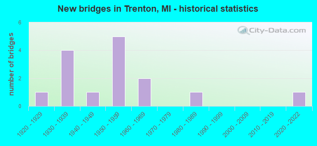
- New bridges - historical statistics
- 11920-1929
- 41930-1939
- 11940-1949
- 51950-1959
- 21960-1969
- 11980-1989
- 12020-2022
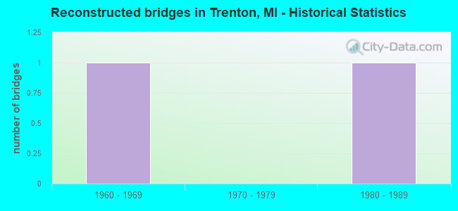
- Reconstructed bridges - Historical Statistics
- 11960-1969
- 01970-1979
- 11980-1989
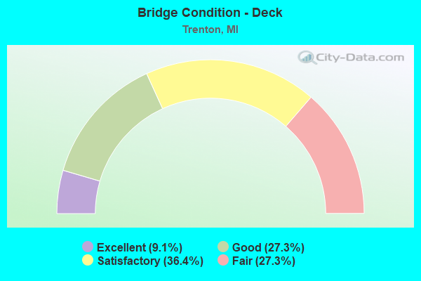
- Bridge Condition - Deck
- 9.1%Excellent
- 27.3%Good
- 36.4%Satisfactory
- 27.3%Fair
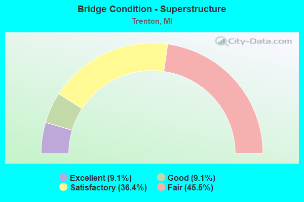
- Bridge Condition - Superstructure
- 9.1%Excellent
- 9.1%Good
- 36.4%Satisfactory
- 45.5%Fair
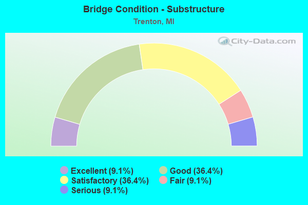
- Bridge Condition - Substructure
- 9.1%Excellent
- 36.4%Good
- 36.4%Satisfactory
- 9.1%Fair
- 9.1%Serious
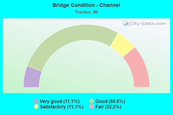
- Bridge Condition - Channel
- 11.1%Very good
- 55.6%Good
- 11.1%Satisfactory
- 22.2%Fair
Find on map >> Show street view
Structure Number: 122, Location: 3.7 MI NE OF SAUGATUCK (Lat: 42.710519, Lng: -86.162647), Route carried "on" structure: County highway , Year Built: 1964, Status: Open, Structure Length: 7.44m (24.41ft), Average Daily Traffic: 178 (year 1996), Truck Traffic: 2%, Average Future Daily Traffic: 140 (year 1977), Design Load: H 15, Features Intersected: I-196 & US-31, Facility Carried by Structure: 140 TH AVE
Minimum Vertical Clearance: 30.48m (100.00ft), Kilometerpoint: 2.665, Lanes on structure: 2, Lanes under structure: 4, Owner: State Highway Agency, Approaching Roadway Width: 9.1m (29.9ft), Skew: 2 degrees, Material/Design: Steel, Design/Construction: Stringer/Multi-beam, Number Of Spans In Main Unit: 4, Length of Maximum Span: 24.4m (80.1ft), Curb or Sidewalk Widths: Left: 0.7m (2.3ft), Right: 0.7m (2.3ft), Curb-To-Curb Width: 7.5m (24.6ft), Out-to-Out Width: 9.6m (31.5ft)
Condition: Deck: Fair, Superstructure: Satisfactory, Substructure: Good, Operating Rating: 51.5 metric tons, Method Used To Determine Operating Rating: Load Factor (LF) rating reported by rating factor (RF) method using MS18 loading, Inventory Rating: 30.8 metric tons, Method Used To Determine Inventory Rating: Load Factor (LF) rating reported by rating factor (RF) method using MS18 loading, Structural Evaluation: Equal to present minimum criteria, Deck Geometry: Somewhat better than minimum adequacy, Underclear: Somewhat better than minimum adequacy, Approach Roadway Alignment: Equal to present desirable criteria, Designated Inspection Frequency: Every 24 months, Inspection Date: May 2021, Deck Structure Type: Concrete Cast-file-Place, Wearing Surface/Protective System: Wearing Surface: Monolithic Concrete
Find on map >> Show street view
Structure Number: 11787, Location: IN TRENTON (Lat: 42.124764, Lng: -83.203361), Route carried "on" structure: State highway 85, Year Built: 1958, Status: Open, Structure Length: 1.68m (5.51ft), Average Daily Traffic: 15,575 (year 2014), Truck Traffic: 7%, Average Future Daily Traffic: 17,325 (year 2036), Design Load: HS 20+Mod, Features Intersected: FRANK & POET DRAIN
Minimum Vertical Clearance: 30.48m (100.00ft), Kilometerpoint: 6.125, Lanes on structure: 2, Base Highway Network: Yes (Inventory Route: 159, Subroute: 5), Owner: State Highway Agency, Approaching Roadway Width: 11.6m (38.1ft), Material/Design: Concrete, Design/Construction: Tee Beam, Number Of Spans In Main Unit: 1, Length of Maximum Span: 16.8m (55.1ft), Curb-To-Curb Width: 13.1m (43.0ft), Out-to-Out Width: 14.0m (45.9ft)
Condition: Deck: Satisfactory, Superstructure: Satisfactory, Substructure: Good, Channel: Satisfactory, Operating Rating: 87.8 metric tons, Method Used To Determine Operating Rating: Load Factor (LF) rating reported by rating factor (RF) method using MS18 loading, Inventory Rating: 52.8 metric tons, Method Used To Determine Inventory Rating: Load Factor (LF) rating reported by rating factor (RF) method using MS18 loading, Structural Evaluation: Equal to present minimum criteria, Deck Geometry: Superior to present desirable criteria, Waterway Adequacy: Equal to present desirable criteria, Approach Roadway Alignment: Equal to present desirable criteria, Designated Inspection Frequency: Every 24 months, Inspection Date: May 2020, Deck Structure Type: Concrete Cast-file-Place, Wearing Surface/Protective System: Wearing Surface: Latex Concrete
Find on map >> Show street view
Structure Number: 11788, Location: IN TRENTON (Lat: 42.125047, Lng: -83.203958), Route carried "on" structure: State highway 85, Year Built: 1958, Status: Open, Structure Length: 1.68m (5.51ft), Average Daily Traffic: 15,575 (year 2014), Truck Traffic: 7%, Average Future Daily Traffic: 17,325 (year 2036), Design Load: HS 20+Mod, Features Intersected: FRANK & POET DRAIN
Minimum Vertical Clearance: 30.48m (100.00ft), Kilometerpoint: 5.908, Lanes on structure: 2, Base Highway Network: Yes (Inventory Route: 159, Subroute: 6), Owner: State Highway Agency, Approaching Roadway Width: 11.6m (38.1ft), Material/Design: Concrete, Design/Construction: Tee Beam, Number Of Spans In Main Unit: 1, Length of Maximum Span: 16.8m (55.1ft), Curb-To-Curb Width: 13.1m (43.0ft), Out-to-Out Width: 14.0m (45.9ft)
Condition: Deck: Good, Superstructure: Fair, Substructure: Good, Channel: Fair, Operating Rating: 86.2 metric tons, Method Used To Determine Operating Rating: Load Factor (LF) rating reported by rating factor (RF) method using MS18 loading, Inventory Rating: 52.2 metric tons, Method Used To Determine Inventory Rating: Load Factor (LF) rating reported by rating factor (RF) method using MS18 loading, Structural Evaluation: Somewhat better than minimum adequacy, Deck Geometry: Superior to present desirable criteria, Waterway Adequacy: Equal to present desirable criteria, Approach Roadway Alignment: Equal to present desirable criteria, Designated Inspection Frequency: Every 24 months, Inspection Date: May 2020, Deck Structure Type: Concrete Cast-file-Place, Wearing Surface/Protective System: Wearing Surface: Latex Concrete
Find on map >> Show street view
Structure Number: 12004, Location: TRENTON W/FORT (Lat: 42.126672, Lng: -83.203194), Route carried "on" structure: County highway 2057, Year Built: 1982, Status: Open, Structure Length: 2.28m (7.48ft), Average Daily Traffic: 23,384 (year 1996), Truck Traffic: 7%, Average Future Daily Traffic: 17,636 (year 2015), Design Load: HS 25 or greater, Features Intersected: FRANK & POET DRAIN, Facility Carried by Structure: VAN HORN ROAD
Minimum Vertical Clearance: 30.48m (100.00ft), Kilometerpoint: 12.246, Lanes on structure: 5, Owner: County Highway Agency, Approaching Roadway Width: 18.9m (62.0ft), Material/Design: Prestressed concrete, Design/Construction: Box Beam or Girders - Multiple, Number Of Spans In Main Unit: 2, Length of Maximum Span: 10.9m (35.8ft), Curb or Sidewalk Widths: Left: 1.6m (5.2ft), Right: 1.6m (5.2ft), Curb-To-Curb Width: 18.9m (62.0ft), Out-to-Out Width: 23.0m (75.5ft)
Condition: Deck: Fair, Superstructure: Fair, Substructure: Satisfactory, Channel: Fair, Operating Rating: 97.2 metric tons, Method Used To Determine Operating Rating: Load Factor (LF) rating reported by rating factor (RF) method using MS18 loading, Inventory Rating: 68.7 metric tons, Method Used To Determine Inventory Rating: Load Factor (LF) rating reported by rating factor (RF) method using MS18 loading, Structural Evaluation: Somewhat better than minimum adequacy, Deck Geometry: Meets minimum limits, Waterway Adequacy: Somewhat better than minimum adequacy, Approach Roadway Alignment: Equal to present desirable criteria, Designated Inspection Frequency: Every 24 months, Inspection Date: November 2020, Deck Structure Type: Concrete Cast-file-Place, Wearing Surface/Protective System: Wearing Surface: Monolithic Concrete, Deck Protection: Epoxy Coated Reinforcing
Find on map >> Show street view
Structure Number: 12005, Location: TRENTON E/JEFFERSON (Lat: 42.127817, Lng: -83.183725), Route carried "on" structure: County highway 2057, Year Built: 1931, Status: Open, Structure Length: 1.58m (5.18ft), Average Daily Traffic: 21,198 (year 1995), Truck Traffic: 2%, Average Future Daily Traffic: 16,574 (year 2015), Design Load: HS 20+Mod, Features Intersected: ELIZABETH PARK CANAL, Facility Carried by Structure: GROSSE ILE PARKWAY
Minimum Vertical Clearance: 30.48m (100.00ft), Kilometerpoint: 0.135, Lanes on structure: 3, Owner: County Highway Agency, Approaching Roadway Width: 15.9m (52.2ft), Material/Design: Concrete, Design/Construction: Arch - Thru, Number Of Spans In Main Unit: 1, Length of Maximum Span: 15.8m (51.8ft), Curb or Sidewalk Widths: Left: 1.8m (5.9ft), Right: 0.2m (0.7ft), Curb-To-Curb Width: 11.6m (38.1ft), Out-to-Out Width: 14.0m (45.9ft)
Condition: Deck: Satisfactory, Superstructure: Satisfactory, Substructure: Satisfactory, Channel: Good, Operating Rating: 39.5 metric tons, Method Used To Determine Operating Rating: Load Factor (LF) rating reported by rating factor (RF) method using MS18 loading, Inventory Rating: 35.3 metric tons, Method Used To Determine Inventory Rating: Load Factor (LF) rating reported by rating factor (RF) method using MS18 loading, Structural Evaluation: Equal to present minimum criteria, Deck Geometry: High priority of replacement, Waterway Adequacy: Equal to present desirable criteria, Approach Roadway Alignment: Equal to present desirable criteria, Designated Inspection Frequency: Every 24 months, Inspection Date: November 2020
Find on map >> Show street view
Structure Number: 12012, Location: TRENTON W/FORT (Lat: 42.141064, Lng: -83.206178), Route carried "on" structure: County highway 2057, Year Built: 2020, Status: Open, Structure Length: 2.86m (9.38ft), Average Daily Traffic: 23,000 (year 2019), Truck Traffic: 8%, Average Future Daily Traffic: 23,100 (year 2039), Design Load: Greater than HL93, Features Intersected: FRANK & POET DRAIN, Facility Carried by Structure: WEST ROAD
Minimum Vertical Clearance: 30.48m (100.00ft), Kilometerpoint: 13.004, Lanes on structure: 5, Base Highway Network: Yes (Inventory Route: 167, Subroute: 10), Owner: County Highway Agency, Approaching Roadway Width: 18.9m (62.0ft), Material/Design: Concrete, Design/Construction: Slab, Number Of Spans In Main Unit: 3, Length of Maximum Span: 11.0m (36.1ft), Curb or Sidewalk Widths: Left: 2.4m (7.9ft), Right: 2.4m (7.9ft), Curb-To-Curb Width: 19.2m (63.0ft), Out-to-Out Width: 24.8m (81.4ft)
Condition: Deck: Excellent, Superstructure: Excellent, Substructure: Excellent, Channel: Very good, Operating Rating: 57.7 metric tons, Method Used To Determine Operating Rating: Load and Resistance Factor Rating (LRFR) rating reported by rating factor(RF) method using HL-93 loadings, Inventory Rating: 44.4 metric tons, Method Used To Determine Inventory Rating: Load and Resistance Factor Rating (LRFR) rating reported by rating factor(RF) method using HL-93 loadings, Structural Evaluation: Superior to present desirable criteria, Deck Geometry: Meets minimum limits, Waterway Adequacy: Equal to present desirable criteria, Approach Roadway Alignment: Equal to present desirable criteria, Designated Inspection Frequency: Every 24 months, Inspection Date: November 2020, Deck Structure Type: Concrete Cast-file-Place, Wearing Surface/Protective System: Wearing Surface: Monolithic Concrete, Deck Protection: Epoxy Coated Reinforcing
Find on map >> Show street view
Structure Number: 12013, Location: TRENTON E/FORT (Lat: 42.141347, Lng: -83.182911), Route carried "on" structure: County highway 2057, Year Built: 1939, Year Reconstructed: 1985, Status: Temporarily open, Structure Length: 37.50m (123.03ft), Average Daily Traffic: 11,876 (year 1997), Truck Traffic: 8%, Average Future Daily Traffic: 14,733 (year 2015), Design Load: HS 20+Mod, Features Intersected: 5TH ST, CONRAIL,GTW RR, Facility Carried by Structure: WEST ROAD
Minimum Vertical Clearance: 30.48m (100.00ft), Kilometerpoint: 14.927, Lanes on structure: 4, Lanes under structure: 9, Base Highway Network: Yes (Inventory Route: 167, Subroute: 10), Owner: County Highway Agency, Approaching Roadway Width: 14.3m (46.9ft), Material/Design: Prestressed concrete, Design/Construction: Stringer/Multi-beam, Number Of Spans In Main Unit: 35, Length of Maximum Span: 13.4m (44.0ft), Curb or Sidewalk Widths: Left: 0.2m (0.7ft), Right: 1.5m (4.9ft), Curb-To-Curb Width: 14.4m (47.2ft), Out-to-Out Width: 16.7m (54.8ft)
Condition: Deck: Satisfactory, Superstructure: Satisfactory, Substructure: Serious, Operating Rating: 55.4 metric tons, Method Used To Determine Operating Rating: Load Factor (LF) rating reported by rating factor (RF) method using MS18 loading, Inventory Rating: 29.2 metric tons, Method Used To Determine Inventory Rating: Load Factor (LF) rating reported by rating factor (RF) method using MS18 loading, Structural Evaluation: High priority of corrective action, Deck Geometry: High priority of replacement, Underclear: High priority of corrective action, Approach Roadway Alignment: Equal to present desirable criteria, Designated Inspection Frequency: Every 12 months, Inspection Date: May 2021, Deck Structure Type: Concrete Cast-file-Place, Wearing Surface/Protective System: Wearing Surface: Integral Concrete, Deck Protection: Epoxy Coated Reinforcing
Find on map >> Show street view
Structure Number: 12185, Location: BROWNSTOWN N/SIBLEY (Lat: 42.170675, Lng: -83.227158), Route carried "on" structure: County highway 2057, Year Built: 1940, Year Reconstructed: 1968, Status: Posted for load, Structure Length: 1.28m (4.20ft), Average Daily Traffic: 24,837 (year 1994), Truck Traffic: 5%, Average Future Daily Traffic: 30,000 (year 2015), Features Intersected: BLAKELY DRAIN, Facility Carried by Structure: ALLEN ROAD
Minimum Vertical Clearance: 30.48m (100.00ft), Kilometerpoint: 7.875, Lanes on structure: 5, Base Highway Network: Yes (Inventory Route: 470, Subroute: 56), Owner: County Highway Agency, Approaching Roadway Width: 18.3m (60.0ft), Skew: 4 degrees, Material/Design: Concrete continuous, Design/Construction: Slab, Number Of Spans In Main Unit: 2, Length of Maximum Span: 5.4m (17.7ft), Curb or Sidewalk Widths: Left: 3.0m (9.8ft), Right: 3.0m (9.8ft), Curb-To-Curb Width: 18.3m (60.0ft), Out-to-Out Width: 25.0m (82.0ft)
Condition: Deck: Good, Superstructure: Good, Substructure: Satisfactory, Channel: Good, Operating Rating: 24.9 metric tons, Method Used To Determine Operating Rating: Load Factor (LF) rating reported by rating factor (RF) method using MS18 loading, Inventory Rating: 14.9 metric tons, Method Used To Determine Inventory Rating: Load Factor (LF) rating reported by rating factor (RF) method using MS18 loading, Structural Evaluation: High priority of corrective action, Deck Geometry: High priority of replacement, Waterway Adequacy: Better than present minimum criteria, Approach Roadway Alignment: Equal to present desirable criteria, Bridge Posting: Required (Relationship of Operating Rating to Maximum Legal Load: > 39.9% below), Designated Inspection Frequency: Every 24 months, Inspection Date: November 2020, Deck Structure Type: Concrete Cast-file-Place, Wearing Surface/Protective System: Wearing Surface: Monolithic Concrete
Find on map >> Show street view
Structure Number: 12303, Location: TRENTON S/WEST RD (Lat: 42.136308, Lng: -83.179000), Route carried "on" structure: County highway 2057, Year Built: 1923, Status: Open, Structure Length: 1.82m (5.97ft), Average Daily Traffic: 5,140 (year 1993), Truck Traffic: 1%, Average Future Daily Traffic: 5,397 (year 2015), Design Load: H 20, Features Intersected: ELIZABETH PK CANAL, Facility Carried by Structure: ELIZABETH PK DRIVE
Minimum Vertical Clearance: 30.48m (100.00ft), Kilometerpoint: 1.009, Lanes on structure: 4, Owner: County Highway Agency, Approaching Roadway Width: 11.9m (39.0ft), Material/Design: Concrete, Design/Construction: Arch - Deck, Number Of Spans In Main Unit: 1, Length of Maximum Span: 18.2m (59.7ft), Curb or Sidewalk Widths: Left: 2.5m (8.2ft), Right: 2.5m (8.2ft), Curb-To-Curb Width: 11.9m (39.0ft), Out-to-Out Width: 18.0m (59.1ft)
Condition: Deck: Fair, Superstructure: Fair, Substructure: Good, Channel: Good, Operating Rating: 95.9 metric tons, Method Used To Determine Operating Rating: Load and Resistance Factor Rating (LRFR) rating reported by rating factor(RF) method using HL-93 loadings, Inventory Rating: 73.2 metric tons, Method Used To Determine Inventory Rating: Load and Resistance Factor Rating (LRFR) rating reported by rating factor(RF) method using HL-93 loadings, Structural Evaluation: Somewhat better than minimum adequacy, Deck Geometry: High priority of replacement, Waterway Adequacy: Equal to present desirable criteria, Approach Roadway Alignment: Meets minimum limits, Designated Inspection Frequency: Every 24 months, Underwater Inspection Frequency: Every 60 months, Inspection Date: November 2020, Underwater Inspection Date: August 2019
Find on map >> Show street view
Structure Number: 12516, Location: IN TRENTON (Lat: 42.133414, Lng: -83.203906), Route carried "on" structure: City street , Year Built: 1959, Status: Open, Structure Length: 1.79m (5.87ft), Average Daily Traffic: 3,300 (year 1993), Truck Traffic: 1%, Average Future Daily Traffic: 3,700 (year 2010), Design Load: HS 20+Mod, Features Intersected: FRANK AND POET DRAIN, Facility Carried by Structure: MARIAN DRIVE
Minimum Vertical Clearance: 30.48m (100.00ft), Kilometerpoint: 1.043, Lanes on structure: 2, Owner: City or Municipal Highway Agency, Approaching Roadway Width: 12.5m (41.0ft), Material/Design: Prestressed concrete, Design/Construction: Box Beam or Girders - Multiple, Number Of Spans In Main Unit: 1, Length of Maximum Span: 17.1m (56.1ft), Curb or Sidewalk Widths: Left: 2.2m (7.2ft), Right: 2.2m (7.2ft), Curb-To-Curb Width: 12.5m (41.0ft), Out-to-Out Width: 16.9m (55.4ft)
Condition: Deck: Satisfactory, Superstructure: Fair, Substructure: Fair, Channel: Good, Operating Rating: 92.0 metric tons, Method Used To Determine Operating Rating: Load Factor (LF) rating reported by rating factor (RF) method using MS18 loading, Inventory Rating: 55.1 metric tons, Method Used To Determine Inventory Rating: Load Factor (LF) rating reported by rating factor (RF) method using MS18 loading, Structural Evaluation: Somewhat better than minimum adequacy, Deck Geometry: Equal to present minimum criteria, Waterway Adequacy: Equal to present desirable criteria, Approach Roadway Alignment: Equal to present minimum criteria, Designated Inspection Frequency: Every 24 months, Inspection Date: June 2021, Deck Structure Type: Other, Wearing Surface/Protective System: Wearing Surface: Bituminous
Find on map >> Show street view
Structure Number: 12517, Location: IN TRENTON (Lat: 42.148242, Lng: -83.206964), Route carried "on" structure: City street , Year Built: 1964, Status: Open, Structure Length: 1.79m (5.87ft), Average Daily Traffic: 2,600 (year 1993), Truck Traffic: 1%, Average Future Daily Traffic: 3,000 (year 2010), Design Load: HS 20+Mod, Features Intersected: FRANK AND POET DRAIN, Facility Carried by Structure: HARRISON AVENUE
Minimum Vertical Clearance: 30.48m (100.00ft), Kilometerpoint: 0.811, Lanes on structure: 2, Owner: City or Municipal Highway Agency, Approaching Roadway Width: 12.5m (41.0ft), Material/Design: Prestressed concrete, Design/Construction: Box Beam or Girders - Multiple, Number Of Spans In Main Unit: 1, Length of Maximum Span: 17.1m (56.1ft), Curb or Sidewalk Widths: Left: 2.2m (7.2ft), Right: 2.2m (7.2ft), Curb-To-Curb Width: 12.5m (41.0ft), Out-to-Out Width: 16.9m (55.4ft)
Condition: Deck: Good, Superstructure: Fair, Substructure: Satisfactory, Channel: Good, Operating Rating: 96.6 metric tons, Method Used To Determine Operating Rating: Load Factor (LF) rating reported by rating factor (RF) method using MS18 loading, Inventory Rating: 57.7 metric tons, Method Used To Determine Inventory Rating: Load Factor (LF) rating reported by rating factor (RF) method using MS18 loading, Structural Evaluation: Somewhat better than minimum adequacy, Deck Geometry: Equal to present minimum criteria, Waterway Adequacy: Equal to present desirable criteria, Approach Roadway Alignment: Equal to present desirable criteria, Designated Inspection Frequency: Every 24 months, Inspection Date: June 2021, Deck Structure Type: Other, Wearing Surface/Protective System: Wearing Surface: Bituminous
Find on map >> Show street view
Structure Number: 12013, Location: TRENTON E/FORT (Lat: 42.141347, Lng: -83.182911), Route carried "under" structure: County highway 2057, Year Built: 1939, Structure Length: 0. m, Average Daily Traffic: 1,000 (year 1992), Features Intersected: 5TH ST, CONRAIL,GTW RR, Facility Carried by Structure: WEST ROAD
Minimum Vertical Clearance: 4.19m (13.75ft), Kilometerpoint: 10.508, Lanes on structure: 4, Lanes under structure: 9, Material/Design: Prestressed concrete, Design/Construction: Stringer/Multi-beam, Length of Maximum Span: 13.4m (44.0ft)
Find on map >> Show street view
Structure Number: 122, Location: TRENTON S/VAN HORN (Lat: 42.120189, Lng: -83.188775), Route carried "under" structure: County highway 2057, Year Built: 1956, Structure Length: 0. m, Average Daily Traffic: 10,098 (year 1995), Truck Traffic: 8%, Features Intersected: JEFFERSON AVENUE, Facility Carried by Structure: PEDESTRIAN WALKWAY
Minimum Vertical Clearance: 4.55m (14.93ft), Kilometerpoint: 9.217, Lanes under structure: 2, Material/Design: Steel, Design/Construction: Truss - Thru, Length of Maximum Span: 37.2m (122.0ft)
Find on map >> Show street view
Structure Number: 12201, Location: TRENTON S/VAN HORN (Lat: 42.124906, Lng: -83.186114), Route carried "under" structure: County highway 2057, Year Built: 1931, Structure Length: 0. m, Average Daily Traffic: 10,098 (year 1995), Truck Traffic: 5%, Features Intersected: W JEFFERSON AVENUE, Facility Carried by Structure: DTE COAL CONVEYOR
Minimum Vertical Clearance: 8.66m (28.41ft), Kilometerpoint: 9.784, Lanes under structure: 2, Material/Design: Steel, Design/Construction: Truss - Thru, Length of Maximum Span: 48.1m (157.8ft)
Find on map >> Show street view
Structure Number: 12207, Location: TRENTON @ KING (Lat: 42.156100, Lng: -83.175011), Route carried "under" structure: County highway 2057, Year Built: 1954, Structure Length: 0. m, Average Daily Traffic: 12,237 (year 1995), Truck Traffic: 5%, Features Intersected: JEFFERSON AVENUE, Facility Carried by Structure: CONRAIL RR
Minimum Vertical Clearance: 4.44m (14.57ft), Kilometerpoint: 13.696, Lanes under structure: 4, Material/Design: Steel, Design/Construction: Girder and Floorbeam System, Length of Maximum Span: 40.2m (131.9ft)