Bridge Statistics for Trenton, New York (NY)
Condition, Traffic, Stress, Structural Evaluation, Project Costs
- National Bridge Inventory (NBI) Statistics
- 31Number of bridges
- 233ft / 70.9mTotal length
- $35,245,000Total costs
- 92,233Total average daily traffic
- 6,869Total average daily truck traffic
- National Bridge Inventory (NBI) Registered Bridges for Trenton
- No street view available for this location
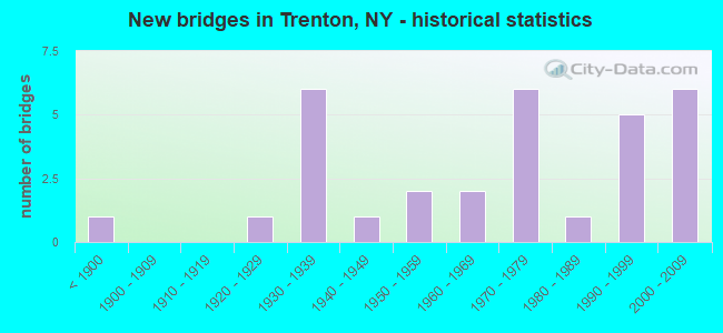
- New bridges - historical statistics
- 1Before 1900
- 11920-1929
- 61930-1939
- 11940-1949
- 21950-1959
- 21960-1969
- 61970-1979
- 11980-1989
- 51990-1999
- 62000-2009

- Reconstructed bridges - Historical Statistics
- 31980-1989
- 21990-1999
- 22000-2009


- Bridge Condition - Deck
- 4.8%Excellent
- 14.3%Very good
- 33.3%Good
- 33.3%Satisfactory
- 9.5%Fair
- 4.8%Poor

- Bridge Condition - Superstructure
- 22.7%Excellent
- 31.8%Very good
- 22.7%Good
- 9.1%Satisfactory
- 9.1%Fair
- 4.5%Poor

- Bridge Condition - Substructure
- 9.1%Excellent
- 18.2%Very good
- 27.3%Good
- 18.2%Satisfactory
- 13.6%Fair
- 13.6%Poor

- Bridge Condition - Channel
- 19.0%Very good
- 19.0%Good
- 33.3%Satisfactory
- 14.3%Fair
- 14.3%Poor

- Bridge Condition - Culverts
- 33.3%Very good
- 33.3%Good
- 33.3%Satisfactory
Find on map >> Show street view
Structure Number: 1009459, Location: 1.4 MI S JCT SH 12 & SH2 (Lat: 43.237506, Lng: -75.182014), Route carried "on" structure: State highway 12, Year Built: 1948, Year Reconstructed: 1991, Status: Open, Structure Length: 0.67m (2.20ft), Average Daily Traffic: 9,655 (year 2020), Truck Traffic: 9%, Average Future Daily Traffic: 10,413 (year 2040), Design Load: HS 20, Features Intersected: NINEMILE FDR CANL
Minimum Vertical Clearance: 30+ m (98+ ft), Kilometerpoint: 51.102, Lanes on structure: 4, Base Highway Network: Yes, Owner: State Highway Agency, Approaching Roadway Width: 19.5m (64.0ft), Skew: 30 degrees, Material/Design: Steel, Design/Construction: Culvert, Number Of Spans In Main Unit: 1, Length of Maximum Span: 6.1m (20.0ft)
Condition: Channel: Good, Culverts: Good, Operating Rating: 76.9 metric tons, Method Used To Determine Operating Rating: Field evaluation and documented engineering judgment, Inventory Rating: 32.7 metric tons, Method Used To Determine Inventory Rating: Field evaluation and documented engineering judgment, Structural Evaluation: Better than present minimum criteria, Waterway Adequacy: Equal to present minimum criteria, Approach Roadway Alignment: Equal to present desirable criteria, Length Of Structure Improvement: 0.64m (2.10ft), Designated Inspection Frequency: Every 24 months, Inspection Date: September 2021, Bridge Improvement Cost: $243,000, Roadway Improvement Cost: $142,000, Total Project Cost: $385,000 ( Estimate for 2021)
Find on map >> Show street view
Structure Number: 1009489, Location: 1.1MI N JCT SH 12 & SH28 (Lat: 43.275717, Lng: -75.183606), Route carried "on" structure: State highway 12, Year Built: 2008, Status: Open, Structure Length: 2.74m (8.99ft), Average Daily Traffic: 9,530 (year 2020), Truck Traffic: 9%, Average Future Daily Traffic: 10,279 (year 2040), Design Load: HL 93, Features Intersected: CINCINNATI CREEK
Minimum Vertical Clearance: 30+ m (98+ ft), Kilometerpoint: 55.334, Lanes on structure: 4, Base Highway Network: Yes, Owner: State Highway Agency, Approaching Roadway Width: 21.9m (71.9ft), Skew: 20 degrees, Material/Design: Prestressed concrete, Design/Construction: Box Beam or Girders - Multiple, Number Of Spans In Main Unit: 1, Length of Maximum Span: 27.0m (88.6ft), Curb-To-Curb Width: 21.3m (69.9ft), Out-to-Out Width: 22.9m (75.1ft)
Condition: Deck: Good, Superstructure: Excellent, Substructure: Excellent, Channel: Very good, Inventory Rating: 74.4 metric tons, Method Used To Determine Inventory Rating: Load Factor (LF), Structural Evaluation: Superior to present desirable criteria, Deck Geometry: Superior to present desirable criteria, Waterway Adequacy: Equal to present desirable criteria, Approach Roadway Alignment: Equal to present desirable criteria, Length Of Structure Improvement: 2.74m (8.99ft), Designated Inspection Frequency: Every 24 months, Inspection Date: November 2020, Bridge Improvement Cost: $1,151,000, Roadway Improvement Cost: $674,000, Total Project Cost: $1,824,000 ( Estimate for 2021), Wearing Surface/Protective System: Wearing Surface: Integral Concrete
Find on map >> Show street view
Structure Number: 1009499, Location: 1.3 MI N JCT SH 12 & SH28 (Lat: 43.276961, Lng: -75.183400), Route carried "on" structure: State highway 12, Year Built: 2008, Status: Open, Structure Length: 1.22m (4.00ft), Average Daily Traffic: 9,530 (year 2020), Truck Traffic: 9%, Average Future Daily Traffic: 10,279 (year 2040), Design Load: HL 93, Features Intersected: PARKER HOLLOW RD
Minimum Vertical Clearance: 30+ m (98+ ft), Kilometerpoint: 55.462, Lanes on structure: 4, Lanes under structure: 2, Base Highway Network: Yes, Owner: State Highway Agency, Approaching Roadway Width: 21.6m (70.9ft), Skew: 33 degrees, Material/Design: Concrete, Design/Construction: Frame, Number Of Spans In Main Unit: 1, Length of Maximum Span: 11.6m (38.1ft), Curb-To-Curb Width: 21.6m (70.9ft), Out-to-Out Width: 40.2m (131.9ft)
Condition: Superstructure: Good, Substructure: Good, Structural Evaluation: Better than present minimum criteria, Deck Geometry: Superior to present desirable criteria, Underclear: High priority of corrective action, Approach Roadway Alignment: Equal to present desirable criteria, Length Of Structure Improvement: 1.21m (3.97ft), Designated Inspection Frequency: Every 24 months, Inspection Date: April 2020, Bridge Improvement Cost: $2,982,000, Roadway Improvement Cost: $1,746,000, Total Project Cost: $4,729,000 ( Estimate for 2021), Wearing Surface/Protective System: Wearing Surface: Bituminous
Find on map >> Show street view
Structure Number: 1009509, Location: 1.8 MI N JCT RTS 28 & 12 (Lat: 43.285406, Lng: -75.183158), Route carried "on" structure: State highway 12, Year Built: 2007, Status: Open, Structure Length: 2.56m (8.40ft), Average Daily Traffic: 9,530 (year 2020), Truck Traffic: 12%, Average Future Daily Traffic: 10,279 (year 2040), Design Load: HL 93, Features Intersected: RTE 365
Minimum Vertical Clearance: 30+ m (98+ ft), Kilometerpoint: 56.412, Lanes on structure: 6, Lanes under structure: 2, Base Highway Network: Yes, Owner: State Highway Agency, Approaching Roadway Width: 29.9m (98.1ft), Skew: 23 degrees, Material/Design: Steel, Design/Construction: Stringer/Multi-beam, Number Of Spans In Main Unit: 1, Length of Maximum Span: 24.0m (78.7ft), Curb-To-Curb Width: 28.7m (94.2ft), Out-to-Out Width: 30.2m (99.1ft)
Condition: Deck: Good, Superstructure: Very good, Substructure: Good, Operating Rating: 88.0 metric tons, Method Used To Determine Operating Rating: Load Factor (LF), Inventory Rating: 52.6 metric tons, Method Used To Determine Inventory Rating: Load Factor (LF), Structural Evaluation: Better than present minimum criteria, Deck Geometry: Superior to present desirable criteria, Underclear: Meets minimum limits, Approach Roadway Alignment: Equal to present desirable criteria, Length Of Structure Improvement: 2.56m (8.40ft), Designated Inspection Frequency: Every 24 months, Inspection Date: April 2021, Bridge Improvement Cost: $2,319,000, Roadway Improvement Cost: $1,358,000, Total Project Cost: $3,676,000 ( Estimate for 2021), Deck Structure Type: Concrete Cast-file-Place, Wearing Surface/Protective System: Wearing Surface: Integral Concrete, Deck Protection: Epoxy Coated Reinforcing
Find on map >> Show street view
Structure Number: 102017, Location: 3.0 MI NW JCT RTS 8 & 28 (Lat: 43.249556, Lng: -75.137783), Route carried "on" structure: State highway 28, Year Built: 1981, Status: Open, Structure Length: 8.87m (29.10ft), Average Daily Traffic: 1,974 (year 2020), Truck Traffic: 16%, Average Future Daily Traffic: 1,986 (year 2040), Design Load: HS 20, Features Intersected: WEST CANADA CREEK
Minimum Vertical Clearance: 30+ m (98+ ft), Kilometerpoint: 0.000, Lanes on structure: 2, Base Highway Network: Yes, Owner: State Highway Agency, Approaching Roadway Width: 14.6m (47.9ft), Skew: 1 degrees, Material/Design: Steel continuous, Design/Construction: Stringer/Multi-beam, Number Of Spans In Main Unit: 2, Length of Maximum Span: 43.5m (142.7ft), Curb-To-Curb Width: 14.6m (47.9ft), Out-to-Out Width: 15.3m (50.2ft)
Condition: Deck: Fair, Superstructure: Good, Substructure: Fair, Channel: Very good, Inventory Rating: 63.5 metric tons, Method Used To Determine Inventory Rating: Load Factor (LF), Structural Evaluation: Somewhat better than minimum adequacy, Deck Geometry: Superior to present desirable criteria, Waterway Adequacy: Equal to present minimum criteria, Approach Roadway Alignment: Equal to present desirable criteria, Length Of Structure Improvement: 8.86m (29.07ft), Designated Inspection Frequency: Every 24 months, Inspection Date: September 2021, Bridge Improvement Cost: $2,233,000, Roadway Improvement Cost: $1,307,000, Total Project Cost: $3,540,000 ( Estimate for 2021), Deck Structure Type: Concrete Cast-file-Place, Wearing Surface/Protective System: Wearing Surface: Integral Concrete, Deck Protection: Epoxy Coated Reinforcing
Find on map >> Show street view
Structure Number: 102019, Location: 2 MI E JCT RTS 28 & 12 (Lat: 43.246239, Lng: -75.154700), Route carried "on" structure: State highway 28, Year Built: 1999, Status: Open, Structure Length: 5.06m (16.60ft), Average Daily Traffic: 1,974 (year 2020), Truck Traffic: 16%, Average Future Daily Traffic: 1,986 (year 2040), Design Load: HS 25 or greater, Features Intersected: CINCINNATI CREEK
Minimum Vertical Clearance: 30+ m (98+ ft), Kilometerpoint: 1.480, Lanes on structure: 2, Base Highway Network: Yes, Owner: State Highway Agency, Approaching Roadway Width: 12.2m (40.0ft), Skew: 3 degrees, Material/Design: Steel, Design/Construction: Stringer/Multi-beam, Number Of Spans In Main Unit: 1, Length of Maximum Span: 48.8m (160.1ft), Curb-To-Curb Width: 12.2m (40.0ft), Out-to-Out Width: 12.8m (42.0ft)
Condition: Deck: Very good, Superstructure: Very good, Substructure: Very good, Channel: Satisfactory, Operating Rating: 89.8 metric tons, Method Used To Determine Operating Rating: Load Factor (LF), Inventory Rating: 50.8 metric tons, Method Used To Determine Inventory Rating: Load Factor (LF), Structural Evaluation: Equal to present desirable criteria, Deck Geometry: Better than present minimum criteria, Waterway Adequacy: Meets minimum limits, Approach Roadway Alignment: Equal to present desirable criteria, Length Of Structure Improvement: 5.05m (16.57ft), Designated Inspection Frequency: Every 24 months, Inspection Date: March 2021, Bridge Improvement Cost: $1,424,000, Roadway Improvement Cost: $834,000, Total Project Cost: $2,258,000 ( Estimate for 2021), Deck Structure Type: Concrete Cast-file-Place, Wearing Surface/Protective System: Wearing Surface: Integral Concrete, Deck Protection: Epoxy Coated Reinforcing
Find on map >> Show street view
Structure Number: 10202, Location: .5 MI E JCT RTS 12 & 28 (Lat: 43.259994, Lng: -75.176083), Route carried "on" structure: State highway 28, Year Built: 1937, Year Reconstructed: 1987, Status: Open, Structure Length: 2.71m (8.89ft), Average Daily Traffic: 1,974 (year 2020), Truck Traffic: 16%, Average Future Daily Traffic: 1,986 (year 2040), Design Load: HS 20, Features Intersected: CINCINNATI CREEK
Minimum Vertical Clearance: 30+ m (98+ ft), Kilometerpoint: 4.023, Lanes on structure: 2, Base Highway Network: Yes, Owner: State Highway Agency, Approaching Roadway Width: 8.5m (27.9ft), Skew: 1 degrees, Material/Design: Steel, Design/Construction: Girder and Floorbeam System, Number Of Spans In Main Unit: 1, Length of Maximum Span: 25.9m (85.0ft), Curb-To-Curb Width: 7.9m (25.9ft), Out-to-Out Width: 9.0m (29.5ft)
Condition: Deck: Fair, Superstructure: Fair, Substructure: Poor, Channel: Very good, Operating Rating: 54.4 metric tons, Method Used To Determine Operating Rating: Allowable Stress (AS), Inventory Rating: 29.0 metric tons, Method Used To Determine Inventory Rating: Allowable Stress (AS), Structural Evaluation: Meets minimum limits, Deck Geometry: Meets minimum limits, Waterway Adequacy: Somewhat better than minimum adequacy, Approach Roadway Alignment: Equal to present desirable criteria, Length Of Structure Improvement: 2.71m (8.89ft), Designated Inspection Frequency: Every 24 months, Critical Feature Inspection Frequency: Every 24 months, Inspection Date: September 2020, Critical Feature Inspection Date: September 2020, Bridge Improvement Cost: $706,000, Roadway Improvement Cost: $413,000, Total Project Cost: $1,119,000 ( Estimate for 2021), Deck Structure Type: Concrete Cast-file-Place, Wearing Surface/Protective System: Wearing Surface: Integral Concrete, Deck Protection: Epoxy Coated Reinforcing
Find on map >> Show street view
Structure Number: 105204, Location: 04MI N JCT RTS 365+12 (Lat: 43.287950, Lng: -75.175428), Route carried "on" structure: State highway 365, Year Built: 1955, Status: Open, Structure Length: 1.37m (4.49ft), Average Daily Traffic: 3,213 (year 2018), Truck Traffic: 5%, Average Future Daily Traffic: 3,351 (year 2040), Design Load: HS 25 or greater, Features Intersected: CINCINNATI CREEK
Minimum Vertical Clearance: 30+ m (98+ ft), Kilometerpoint: 48.415, Lanes on structure: 2, Base Highway Network: Yes, Owner: State Highway Agency, Approaching Roadway Width: 11.9m (39.0ft), Skew: 2 degrees, Material/Design: Concrete, Design/Construction: Culvert, Number Of Spans In Main Unit: 1, Length of Maximum Span: 13.1m (43.0ft)
Condition: Channel: Good, Culverts: Satisfactory, Operating Rating: 81.9 metric tons, Method Used To Determine Operating Rating: Field evaluation and documented engineering judgment, Inventory Rating: 40.8 metric tons, Method Used To Determine Inventory Rating: Field evaluation and documented engineering judgment, Structural Evaluation: Equal to present minimum criteria, Waterway Adequacy: Somewhat better than minimum adequacy, Approach Roadway Alignment: Equal to present desirable criteria, Length Of Structure Improvement: 1.37m (4.49ft), Designated Inspection Frequency: Every 24 months, Inspection Date: September 2020, Bridge Improvement Cost: $318,000, Roadway Improvement Cost: $186,000, Total Project Cost: $504,000 ( Estimate for 2021), Wearing Surface/Protective System: Wearing Surface: Bituminous
Find on map >> Show street view
Structure Number: 1090401, Location: 7 MI N JCT RTS 12 & 49 (Lat: 43.208106, Lng: -75.171603), Route carried "on" structure: State highway 12, Year Built: 1971, Status: Open, Structure Length: 3.11m (10.20ft), Average Daily Traffic: 4,828 (year 2020), Truck Traffic: 9%, Average Future Daily Traffic: 7,533 (year 2040), Design Load: HS 20, Features Intersected: NINE MILE CREEK
Minimum Vertical Clearance: 30+ m (98+ ft), Kilometerpoint: 47.659, Lanes on structure: 2, Base Highway Network: Yes, Owner: State Highway Agency, Approaching Roadway Width: 7.3m (24.0ft), Material/Design: Steel, Design/Construction: Stringer/Multi-beam, Number Of Spans In Main Unit: 1, Length of Maximum Span: 29.8m (97.8ft), Curb-To-Curb Width: 12.5m (41.0ft), Out-to-Out Width: 13.4m (44.0ft)
Condition: Deck: Good, Superstructure: Excellent, Substructure: Very good, Channel: Good, Operating Rating: 88.0 metric tons, Method Used To Determine Operating Rating: Load Factor (LF), Inventory Rating: 52.6 metric tons, Method Used To Determine Inventory Rating: Load Factor (LF), Structural Evaluation: Equal to present desirable criteria, Deck Geometry: Better than present minimum criteria, Waterway Adequacy: Equal to present minimum criteria, Approach Roadway Alignment: Equal to present desirable criteria, Length Of Structure Improvement: 3.10m (10.17ft), Designated Inspection Frequency: Every 24 months, Inspection Date: April 2021, Bridge Improvement Cost: $765,000, Roadway Improvement Cost: $448,000, Total Project Cost: $1,213,000 ( Estimate for 2021), Deck Structure Type: Concrete Cast-file-Place, Wearing Surface/Protective System: Wearing Surface: Monolithic Concrete
Find on map >> Show street view
Structure Number: 1090402, Location: 7 MI N JCT RTS 12 & 49 (Lat: 43.208228, Lng: -75.171164), Route carried "on" structure: State highway 12, Year Built: 1971, Status: Open, Structure Length: 3.38m (11.09ft), Average Daily Traffic: 4,828 (year 2020), Truck Traffic: 9%, Average Future Daily Traffic: 7,533 (year 2040), Design Load: HS 20, Features Intersected: NINE MILE CREEK
Minimum Vertical Clearance: 30+ m (98+ ft), Kilometerpoint: 47.659, Lanes on structure: 2, Base Highway Network: Yes, Owner: State Highway Agency, Approaching Roadway Width: 7.3m (24.0ft), Material/Design: Steel, Design/Construction: Stringer/Multi-beam, Number Of Spans In Main Unit: 1, Length of Maximum Span: 32.6m (107.0ft), Curb-To-Curb Width: 12.5m (41.0ft), Out-to-Out Width: 13.4m (44.0ft)
Condition: Deck: Satisfactory, Superstructure: Very good, Substructure: Very good, Channel: Satisfactory, Operating Rating: 86.2 metric tons, Method Used To Determine Operating Rating: Load Factor (LF), Inventory Rating: 51.7 metric tons, Method Used To Determine Inventory Rating: Load Factor (LF), Structural Evaluation: Equal to present desirable criteria, Deck Geometry: Better than present minimum criteria, Waterway Adequacy: Somewhat better than minimum adequacy, Approach Roadway Alignment: Equal to present desirable criteria, Length Of Structure Improvement: 3.38m (11.09ft), Designated Inspection Frequency: Every 24 months, Inspection Date: April 2021, Bridge Improvement Cost: $841,000, Roadway Improvement Cost: $493,000, Total Project Cost: $1,334,000 ( Estimate for 2021), Deck Structure Type: Concrete Cast-file-Place, Wearing Surface/Protective System: Wearing Surface: Monolithic Concrete
Find on map >> Show street view
Structure Number: 1090421, Location: 7.8 MI N JCT SH 12 & SH49 (Lat: 43.221986, Lng: -75.176336), Route carried "on" structure: State highway 12, Year Built: 1971, Status: Open, Structure Length: 3.93m (12.89ft), Average Daily Traffic: 4,828 (year 2020), Truck Traffic: 9%, Average Future Daily Traffic: 7,533 (year 2040), Design Load: HS 20, Features Intersected: PUTNAM ROAD
Minimum Vertical Clearance: 30+ m (98+ ft), Kilometerpoint: 49.251, Lanes on structure: 2, Lanes under structure: 2, Base Highway Network: Yes, Owner: State Highway Agency, Approaching Roadway Width: 7.3m (24.0ft), Material/Design: Steel, Design/Construction: Stringer/Multi-beam, Number Of Spans In Main Unit: 1, Length of Maximum Span: 38.1m (125.0ft), Curb-To-Curb Width: 12.5m (41.0ft), Out-to-Out Width: 13.4m (44.0ft)
Condition: Deck: Good, Superstructure: Very good, Substructure: Good, Operating Rating: 81.6 metric tons, Method Used To Determine Operating Rating: Load Factor (LF), Inventory Rating: 48.1 metric tons, Method Used To Determine Inventory Rating: Load Factor (LF), Structural Evaluation: Better than present minimum criteria, Deck Geometry: Better than present minimum criteria, Underclear: Somewhat better than minimum adequacy, Approach Roadway Alignment: Equal to present desirable criteria, Length Of Structure Improvement: 3.90m (12.80ft), Designated Inspection Frequency: Every 24 months, Inspection Date: May 2021, Bridge Improvement Cost: $1,037,000, Roadway Improvement Cost: $607,000, Total Project Cost: $1,644,000 ( Estimate for 2021), Deck Structure Type: Concrete Cast-file-Place, Wearing Surface/Protective System: Wearing Surface: Monolithic Concrete
Find on map >> Show street view
Structure Number: 1090422, Location: 7.8 MI N JCT SH 12 & SH49 (Lat: 43.222042, Lng: -75.175875), Route carried "on" structure: State highway 12, Year Built: 1971, Status: Open, Structure Length: 3.93m (12.89ft), Average Daily Traffic: 4,828 (year 2020), Truck Traffic: 9%, Average Future Daily Traffic: 7,533 (year 2040), Design Load: HS 20, Features Intersected: PUTNAM ROAD
Minimum Vertical Clearance: 30+ m (98+ ft), Kilometerpoint: 49.251, Lanes on structure: 2, Lanes under structure: 2, Base Highway Network: Yes, Owner: State Highway Agency, Approaching Roadway Width: 7.6m (24.9ft), Material/Design: Steel, Design/Construction: Stringer/Multi-beam, Number Of Spans In Main Unit: 1, Length of Maximum Span: 38.1m (125.0ft), Curb-To-Curb Width: 12.5m (41.0ft), Out-to-Out Width: 13.4m (44.0ft)
Condition: Deck: Satisfactory, Superstructure: Very good, Substructure: Good, Operating Rating: 86.2 metric tons, Method Used To Determine Operating Rating: Load Factor (LF), Inventory Rating: 50.8 metric tons, Method Used To Determine Inventory Rating: Load Factor (LF), Structural Evaluation: Better than present minimum criteria, Deck Geometry: Better than present minimum criteria, Underclear: Somewhat better than minimum adequacy, Approach Roadway Alignment: Equal to present desirable criteria, Length Of Structure Improvement: 3.90m (12.80ft), Designated Inspection Frequency: Every 24 months, Inspection Date: April 2021, Bridge Improvement Cost: $1,037,000, Roadway Improvement Cost: $607,000, Total Project Cost: $1,644,000 ( Estimate for 2021), Deck Structure Type: Concrete Cast-file-Place, Wearing Surface/Protective System: Wearing Surface: Monolithic Concrete
Find on map >> Show street view
Structure Number: 220596, Location: .2 MI W SH12 AT BARNEVELD (Lat: 43.272883, Lng: -75.187258), Route carried "on" structure: Other road , Year Built: 1930, Status: Posted for load, Structure Length: 3.20m (10.50ft), Average Daily Traffic: 454 (year 2016), Truck Traffic: 5%, Average Future Daily Traffic: 636 (year 2036), Design Load: H 15, Features Intersected: CINCINNATI CREEK, Facility Carried by Structure: CR56 OLD POLAND RO
Minimum Vertical Clearance: 30+ m (98+ ft), Kilometerpoint: 0.193, Lanes on structure: 2, Owner: Town or Township Highway Agency, Approaching Roadway Width: 6.4m (21.0ft), Skew: 1 degrees, Material/Design: Steel, Design/Construction: Girder and Floorbeam System, Number Of Spans In Main Unit: 1, Length of Maximum Span: 30.4m (99.7ft), Curb or Sidewalk Widths: Left: 1.6m (5.2ft), Right: 0.0m, Curb-To-Curb Width: 7.3m (24.0ft), Out-to-Out Width: 8.4m (27.6ft)
Condition: Deck: Poor, Superstructure: Poor, Substructure: Poor, Channel: Satisfactory, Operating Rating: 18.5 metric tons, Method Used To Determine Operating Rating: Load and Resistance Factor Rating (LRFR) rating reported by rating factor(RF) method using HL-93 loadings, Inventory Rating: 14.3 metric tons, Method Used To Determine Inventory Rating: Load and Resistance Factor Rating (LRFR) rating reported by rating factor(RF) method using HL-93 loadings, Structural Evaluation: Meets minimum limits, Deck Geometry: Meets minimum limits, Waterway Adequacy: Somewhat better than minimum adequacy, Approach Roadway Alignment: Equal to present minimum criteria, Bridge Posting: Required (Relationship of Operating Rating to Maximum Legal Load: > 39.9% below), Length Of Structure Improvement: 3.20m (10.50ft), Designated Inspection Frequency: Every 12 months, Critical Feature Inspection Frequency: Every 12 months, Inspection Date: August 2021, Critical Feature Inspection Date: August 2021, Bridge Improvement Cost: $600,000, Roadway Improvement Cost: $351,000, Total Project Cost: $952,000 ( Estimate for 2021), Deck Structure Type: Concrete Cast-file-Place, Wearing Surface/Protective System: Wearing Surface: Integral Concrete
Find on map >> Show street view
Structure Number: 2206, Location: AT HOLLAND PATENT (Lat: 43.228556, Lng: -75.266317), Route carried "on" structure: Other road , Year Built: 1933, Year Reconstructed: 2004, Status: Open, Structure Length: 2.29m (7.51ft), Average Daily Traffic: 287 (year 2019), Truck Traffic: 4%, Average Future Daily Traffic: 402 (year 2039), Design Load: HS 25 or greater, Features Intersected: NINE MILE CREEK, Facility Carried by Structure: MILLER ROAD
Minimum Vertical Clearance: 30+ m (98+ ft), Kilometerpoint: 0.644, Lanes on structure: 2, Owner: Town or Township Highway Agency, Approaching Roadway Width: 7.3m (24.0ft), Material/Design: Prestressed concrete, Design/Construction: Box Beam or Girders - Multiple, Number Of Spans In Main Unit: 1, Length of Maximum Span: 22.2m (72.8ft), Curb-To-Curb Width: 6.6m (21.7ft), Out-to-Out Width: 6.8m (22.3ft)
Condition: Deck: Excellent, Superstructure: Excellent, Substructure: Fair, Channel: Poor, Operating Rating: 66.2 metric tons, Method Used To Determine Operating Rating: Load Factor (LF), Inventory Rating: 42.6 metric tons, Method Used To Determine Inventory Rating: Load Factor (LF), Structural Evaluation: Somewhat better than minimum adequacy, Deck Geometry: Meets minimum limits, Waterway Adequacy: Meets minimum limits, Approach Roadway Alignment: High priority of replacement, Length Of Structure Improvement: 2.28m (7.48ft), Designated Inspection Frequency: Every 24 months, Inspection Date: May 2020, Bridge Improvement Cost: $376,000, Roadway Improvement Cost: $220,000, Total Project Cost: $596,000 ( Estimate for 2021), Wearing Surface/Protective System: Wearing Surface: Bituminous
Find on map >> Show street view
Structure Number: 220601, Location: 3.5 MILES SW OF BARNEVELD (Lat: 43.221325, Lng: -75.208103), Route carried "on" structure: Other road , Year Built: 1920, Year Reconstructed: 1993, Status: Open, Structure Length: 2.59m (8.50ft), Average Daily Traffic: 32 (year 2018), Truck Traffic: 26%, Average Future Daily Traffic: 45 (year 2038), Features Intersected: NINE MILE CREEK, Facility Carried by Structure: HOFFMAN ROAD
Minimum Vertical Clearance: 30+ m (98+ ft), Kilometerpoint: 1.094, Lanes on structure: 1, Owner: Town or Township Highway Agency, Approaching Roadway Width: 4.9m (16.1ft), Material/Design: Prestressed concrete, Design/Construction: Box Beam or Girders - Multiple, Number Of Spans In Main Unit: 1, Length of Maximum Span: 23.4m (76.8ft), Curb-To-Curb Width: 4.9m (16.1ft), Out-to-Out Width: 5.0m (16.4ft)
Condition: Deck: Satisfactory, Superstructure: Satisfactory, Substructure: Poor, Channel: Poor, Operating Rating: 78.0 metric tons, Method Used To Determine Operating Rating: Load Factor (LF), Inventory Rating: 51.7 metric tons, Method Used To Determine Inventory Rating: Load Factor (LF), Structural Evaluation: Meets minimum limits, Deck Geometry: High priority of corrective action, Waterway Adequacy: Meets minimum limits, Approach Roadway Alignment: Somewhat better than minimum adequacy, Length Of Structure Improvement: 2.59m (8.50ft), Designated Inspection Frequency: Every 24 months, Inspection Date: August 2021, Bridge Improvement Cost: $333,000, Roadway Improvement Cost: $195,000, Total Project Cost: $528,000 ( Estimate for 2021), Wearing Surface/Protective System: Wearing Surface: Bituminous
Find on map >> Show street view
Structure Number: 220602, Location: 2 MILES NORTH BARNEVELD (Lat: 43.295525, Lng: -75.181839), Route carried "on" structure: Other road , Year Built: 1994, Status: Open, Structure Length: 1.71m (5.61ft), Average Daily Traffic: 45 (year 2017), Truck Traffic: 5%, Average Future Daily Traffic: 63 (year 2037), Features Intersected: CINCINNATI CREEK, Facility Carried by Structure: TAYLOR ROAD
Minimum Vertical Clearance: 30+ m (98+ ft), Kilometerpoint: 0.097, Lanes on structure: 1, Owner: Town or Township Highway Agency, Approaching Roadway Width: 5.5m (18.0ft), Material/Design: Prestressed concrete, Design/Construction: Box Beam or Girders - Multiple, Number Of Spans In Main Unit: 1, Length of Maximum Span: 15.2m (49.9ft), Curb-To-Curb Width: 4.9m (16.1ft), Out-to-Out Width: 4.9m (16.1ft)
Condition: Deck: Good, Superstructure: Good, Substructure: Satisfactory, Channel: Satisfactory, Operating Rating: 48.6 metric tons, Method Used To Determine Operating Rating: Load and Resistance Factor Rating (LRFR) rating reported by rating factor(RF) method using HL-93 loadings, Inventory Rating: 37.3 metric tons, Method Used To Determine Inventory Rating: Load and Resistance Factor Rating (LRFR) rating reported by rating factor(RF) method using HL-93 loadings, Structural Evaluation: Equal to present minimum criteria, Deck Geometry: High priority of corrective action, Waterway Adequacy: Meets minimum limits, Approach Roadway Alignment: Better than present minimum criteria, Length Of Structure Improvement: 1.70m (5.58ft), Designated Inspection Frequency: Every 24 months, Inspection Date: September 2020, Bridge Improvement Cost: $133,000, Roadway Improvement Cost: $78,000, Total Project Cost: $211,000 ( Estimate for 2021), Wearing Surface/Protective System: Wearing Surface: Bituminous
Find on map >> Show street view
Structure Number: 220603, Location: 3 MI N BARNEVELD (Lat: 43.308803, Lng: -75.184233), Route carried "on" structure: Other road , Year Built: 1999, Status: Open, Structure Length: 1.37m (4.49ft), Average Daily Traffic: 51 (year 2016), Truck Traffic: 4%, Average Future Daily Traffic: 71 (year 2036), Features Intersected: CINCINNATI CREEK, Facility Carried by Structure: PROSPECT JUNCTION
Minimum Vertical Clearance: 30+ m (98+ ft), Kilometerpoint: 0.113, Lanes on structure: 2, Owner: Town or Township Highway Agency, Approaching Roadway Width: 5.2m (17.1ft), Material/Design: Prestressed concrete, Design/Construction: Box Beam or Girders - Multiple, Number Of Spans In Main Unit: 1, Length of Maximum Span: 13.4m (44.0ft), Curb-To-Curb Width: 5.4m (17.7ft), Out-to-Out Width: 5.5m (18.0ft)
Condition: Deck: Very good, Superstructure: Very good, Substructure: Fair, Channel: Fair, Operating Rating: 56.7 metric tons, Method Used To Determine Operating Rating: Load and Resistance Factor Rating (LRFR) rating reported by rating factor(RF) method using HL-93 loadings, Inventory Rating: 42.4 metric tons, Method Used To Determine Inventory Rating: Load and Resistance Factor Rating (LRFR) rating reported by rating factor(RF) method using HL-93 loadings, Structural Evaluation: Somewhat better than minimum adequacy, Deck Geometry: High priority of corrective action, Waterway Adequacy: Meets minimum limits, Approach Roadway Alignment: Equal to present desirable criteria, Length Of Structure Improvement: 1.37m (4.49ft), Designated Inspection Frequency: Every 24 months, Inspection Date: August 2021, Bridge Improvement Cost: $163,000, Roadway Improvement Cost: $96,000, Total Project Cost: $259,000 ( Estimate for 2021), Wearing Surface/Protective System: Wearing Surface: Bituminous, Membrane: Other
Find on map >> Show street view
Structure Number: 220606, Location: 2 MILES NE OF BARNEVELD (Lat: 43.284225, Lng: -75.170244), Route carried "on" structure: Other road , Year Built: 1880, Year Reconstructed: 1999, Status: Open, Structure Length: 1.52m (4.99ft), Average Daily Traffic: 81 (year 2016), Truck Traffic: 4%, Average Future Daily Traffic: 113 (year 2036), Features Intersected: CINCINNATI CREEK, Facility Carried by Structure: PARKER HOLLOW RD
Minimum Vertical Clearance: 30+ m (98+ ft), Kilometerpoint: 1.561, Lanes on structure: 2, Owner: Town or Township Highway Agency, Approaching Roadway Width: 5.5m (18.0ft), Material/Design: Masonry, Design/Construction: Arch - Deck, Number Of Spans In Main Unit: 2, Length of Maximum Span: 6.7m (22.0ft), Curb-To-Curb Width: 7.2m (23.6ft), Out-to-Out Width: 8.0m (26.2ft)
Condition: Deck: Satisfactory, Superstructure: Satisfactory, Substructure: Satisfactory, Channel: Poor, Operating Rating: 50.8 metric tons, Method Used To Determine Operating Rating: Load Factor (LF), Inventory Rating: 37.2 metric tons, Method Used To Determine Inventory Rating: Load Factor (LF), Structural Evaluation: Equal to present minimum criteria, Deck Geometry: Somewhat better than minimum adequacy, Waterway Adequacy: Meets minimum limits, Approach Roadway Alignment: High priority of replacement, Length Of Structure Improvement: 1.52m (4.99ft), Designated Inspection Frequency: Every 24 months, Inspection Date: August 2021, Bridge Improvement Cost: $462,000, Roadway Improvement Cost: $271,000, Total Project Cost: $733,000 ( Estimate for 2021)
Find on map >> Show street view
Structure Number: 331105, Location: 2.4 Mi East of Holland Pa (Lat: 43.230511, Lng: -75.239056), Route carried "on" structure: County highway , Year Built: 1957, Status: Open, Structure Length: 2.56m (8.40ft), Average Daily Traffic: 785 (year 2016), Truck Traffic: 5%, Average Future Daily Traffic: 1,099 (year 2036), Design Load: H 20, Features Intersected: NINE MILE CREEK, Facility Carried by Structure: CR36 GLASS FACTORY
Minimum Vertical Clearance: 30+ m (98+ ft), Kilometerpoint: 9.429, Lanes on structure: 2, Owner: County Highway Agency, Approaching Roadway Width: 6.4m (21.0ft), Skew: 2 degrees, Material/Design: Steel, Design/Construction: Stringer/Multi-beam, Number Of Spans In Main Unit: 1, Length of Maximum Span: 24.3m (79.7ft), Curb-To-Curb Width: 7.5m (24.6ft), Out-to-Out Width: 7.6m (24.9ft)
Condition: Deck: Satisfactory, Superstructure: Good, Substructure: Satisfactory, Channel: Fair, Operating Rating: 36.3 metric tons, Method Used To Determine Operating Rating: Load and Resistance Factor Rating (LRFR) rating reported by rating factor(RF) method using HL-93 loadings, Inventory Rating: 28.2 metric tons, Method Used To Determine Inventory Rating: Load and Resistance Factor Rating (LRFR) rating reported by rating factor(RF) method using HL-93 loadings, Structural Evaluation: Equal to present minimum criteria, Deck Geometry: Meets minimum limits, Waterway Adequacy: Better than present minimum criteria, Approach Roadway Alignment: Equal to present minimum criteria, Length Of Structure Improvement: 2.56m (8.40ft), Designated Inspection Frequency: Every 24 months, Inspection Date: July 2020, Bridge Improvement Cost: $490,000, Roadway Improvement Cost: $287,000, Total Project Cost: $777,000 ( Estimate for 2021), Deck Structure Type: Open Grating, Wearing Surface/Protective System: Wearing Surface: Other
Find on map >> Show street view
Structure Number: 331106, Location: 3.5 MI SW OF BARNEVELD (Lat: 43.236211, Lng: -75.253194), Route carried "on" structure: County highway , Year Built: 1960, Year Reconstructed: 2013, Status: Open, Structure Length: 2.56m (8.40ft), Average Daily Traffic: 1,009 (year 2016), Truck Traffic: 5%, Average Future Daily Traffic: 1,413 (year 2036), Design Load: HS 20, Features Intersected: NINE MILE CREEK, Facility Carried by Structure: CR38 FOX ROAD
Minimum Vertical Clearance: 30+ m (98+ ft), Kilometerpoint: 8.270, Lanes on structure: 2, Owner: County Highway Agency, Approaching Roadway Width: 6.4m (21.0ft), Material/Design: Steel, Design/Construction: Stringer/Multi-beam, Number Of Spans In Main Unit: 1, Length of Maximum Span: 24.3m (79.7ft), Curb-To-Curb Width: 7.5m (24.6ft), Out-to-Out Width: 7.7m (25.3ft)
Condition: Deck: Good, Superstructure: Very good, Substructure: Good, Channel: Good, Operating Rating: 56.2 metric tons, Method Used To Determine Operating Rating: Load Factor (LF), Inventory Rating: 33.6 metric tons, Method Used To Determine Inventory Rating: Load Factor (LF), Structural Evaluation: Better than present minimum criteria, Deck Geometry: Meets minimum limits, Waterway Adequacy: Meets minimum limits, Approach Roadway Alignment: Equal to present desirable criteria, Length Of Structure Improvement: 2.56m (8.40ft), Designated Inspection Frequency: Every 24 months, Inspection Date: August 2020, Bridge Improvement Cost: $514,000, Roadway Improvement Cost: $301,000, Total Project Cost: $816,000 ( Estimate for 2021), Deck Structure Type: Open Grating, Wearing Surface/Protective System: Wearing Surface: Other
Find on map >> Show street view
Structure Number: 331107, Location: 1 MI SW HINKLEY RESERVOIR (Lat: 43.303078, Lng: -75.146797), Route carried "on" structure: County highway , Year Built: 1998, Status: Open, Structure Length: 5.55m (18.21ft), Truck Traffic: 10%, Design Load: HS 25 or greater, Features Intersected: WEST CANADA CREEK, Facility Carried by Structure: CR15 SOUTH STATE S
Minimum Vertical Clearance: 30+ m (98+ ft), Kilometerpoint: 0.097, Lanes on structure: 2, Owner: County Highway Agency, Approaching Roadway Width: 7.9m (25.9ft), Material/Design: Wood or Timber, Design/Construction: Arch - Deck, Number Of Spans In Main Unit: 1, Number Of Approach Spans: 4, Length of Maximum Span: 40.5m (132.9ft), Curb-To-Curb Width: 7.8m (25.6ft), Out-to-Out Width: 8.4m (27.6ft)
Condition: Deck: Satisfactory, Superstructure: Good, Substructure: Good, Channel: Satisfactory, Operating Rating: 74.5 metric tons, Method Used To Determine Operating Rating: Field evaluation and documented engineering judgment, Inventory Rating: 40.8 metric tons, Method Used To Determine Inventory Rating: Field evaluation and documented engineering judgment, Structural Evaluation: Better than present minimum criteria, Deck Geometry: Equal to present minimum criteria, Waterway Adequacy: Meets minimum limits, Approach Roadway Alignment: Equal to present desirable criteria, Length Of Structure Improvement: 5.54m (18.18ft), Designated Inspection Frequency: Every 24 months, Inspection Date: June 2020, Bridge Improvement Cost: $2,340,000, Roadway Improvement Cost: $1,370,000, Total Project Cost: $3,710,000 ( Estimate for 2021), Wearing Surface/Protective System: Wearing Surface: Bituminous, Membrane: Other
Find on map >> Show street view
Structure Number: 331108, Location: 2.5 MI NW OF BARNEVELD (Lat: 43.289181, Lng: -75.223942), Route carried "on" structure: County highway , Year Built: 1969, Status: Open, Structure Length: 1.65m (5.41ft), Average Daily Traffic: 300 (year 2016), Truck Traffic: 4%, Average Future Daily Traffic: 420 (year 2036), Design Load: H 20, Features Intersected: STEUBEN CREEK, Facility Carried by Structure: CR 56 STEUBEN VALL
Minimum Vertical Clearance: 30+ m (98+ ft), Kilometerpoint: 4.232, Lanes on structure: 2, Owner: County Highway Agency, Approaching Roadway Width: 6.1m (20.0ft), Skew: 3 degrees, Material/Design: Steel, Design/Construction: Stringer/Multi-beam, Number Of Spans In Main Unit: 1, Length of Maximum Span: 15.2m (49.9ft), Curb-To-Curb Width: 7.5m (24.6ft), Out-to-Out Width: 7.7m (25.3ft)
Condition: Deck: Satisfactory, Superstructure: Fair, Substructure: Satisfactory, Channel: Fair, Operating Rating: 50.8 metric tons, Method Used To Determine Operating Rating: Load Factor (LF), Inventory Rating: 29.9 metric tons, Method Used To Determine Inventory Rating: Load Factor (LF), Structural Evaluation: Somewhat better than minimum adequacy, Deck Geometry: Somewhat better than minimum adequacy, Waterway Adequacy: Meets minimum limits, Approach Roadway Alignment: Better than present minimum criteria, Length Of Structure Improvement: 1.64m (5.38ft), Designated Inspection Frequency: Every 24 months, Inspection Date: June 2020, Bridge Improvement Cost: $378,000, Roadway Improvement Cost: $221,000, Total Project Cost: $599,000 ( Estimate for 2021), Deck Structure Type: Concrete Cast-file-Place, Wearing Surface/Protective System: Wearing Surface: Bituminous
Find on map >> Show street view
Structure Number: 331109, Location: .3 MI S INT SH12 & PUTMN (Lat: 43.215861, Lng: -75.179433), Route carried "on" structure: County highway , Year Built: 2005, Status: Open, Structure Length: 4.75m (15.58ft), Average Daily Traffic: 889 (year 2020), Truck Traffic: 6%, Average Future Daily Traffic: 927 (year 2040), Design Load: HS 20, Features Intersected: NINE MILE CREEK, Facility Carried by Structure: CR 91 TRENTON RD
Minimum Vertical Clearance: 30+ m (98+ ft), Kilometerpoint: 11.166, Lanes on structure: 2, Owner: County Highway Agency, Approaching Roadway Width: 10.7m (35.1ft), Skew: 3 degrees, Material/Design: Steel, Design/Construction: Stringer/Multi-beam, Number Of Spans In Main Unit: 1, Length of Maximum Span: 47.0m (154.2ft), Curb-To-Curb Width: 10.2m (33.5ft), Out-to-Out Width: 11.2m (36.7ft)
Condition: Deck: Good, Superstructure: Excellent, Substructure: Excellent, Channel: Satisfactory, Operating Rating: 98.0 metric tons, Method Used To Determine Operating Rating: Load Factor (LF), Inventory Rating: 58.1 metric tons, Method Used To Determine Inventory Rating: Load Factor (LF), Structural Evaluation: Superior to present desirable criteria, Deck Geometry: Equal to present minimum criteria, Waterway Adequacy: Equal to present minimum criteria, Approach Roadway Alignment: Equal to present desirable criteria, Length Of Structure Improvement: 4.75m (15.58ft), Designated Inspection Frequency: Every 24 months, Inspection Date: July 2021, Bridge Improvement Cost: $949,000, Roadway Improvement Cost: $556,000, Total Project Cost: $1,505,000 ( Estimate for 2021), Deck Structure Type: Concrete Cast-file-Place, Wearing Surface/Protective System: Wearing Surface: Integral Concrete, Deck Protection: Epoxy Coated Reinforcing
Find on map >> Show street view
Structure Number: 33701, Location: IN HOLLAND PATENT (Lat: 43.237664, Lng: -75.246444), Route carried "on" structure: County highway , Year Built: 1935, Year Reconstructed: 2009, Status: Open, Structure Length: 0.70m (2.30ft), Average Daily Traffic: 1,172 (year 2020), Truck Traffic: 6%, Average Future Daily Traffic: 1,641 (year 2040), Design Load: HL 93, Features Intersected: BEAVER CREEK, Facility Carried by Structure: CR35 POWELL ROAD
Minimum Vertical Clearance: 30+ m (98+ ft), Kilometerpoint: 0.418, Lanes on structure: 2, Owner: County Highway Agency, Approaching Roadway Width: 6.1m (20.0ft), Skew: 1 degrees, Material/Design: Prestressed concrete, Design/Construction: Box Beam or Girders - Multiple, Number Of Spans In Main Unit: 1, Length of Maximum Span: 6.7m (22.0ft), Curb-To-Curb Width: 6.9m (22.6ft), Out-to-Out Width: 7.7m (25.3ft)
Condition: Deck: Very good, Superstructure: Excellent, Substructure: Very good, Channel: Satisfactory, Operating Rating: 63.5 metric tons, Method Used To Determine Operating Rating: Load Factor (LF), Inventory Rating: 37.2 metric tons, Method Used To Determine Inventory Rating: Load Factor (LF), Structural Evaluation: Equal to present desirable criteria, Deck Geometry: High priority of corrective action, Waterway Adequacy: Meets minimum limits, Approach Roadway Alignment: Equal to present desirable criteria, Length Of Structure Improvement: 0.70m (2.30ft), Designated Inspection Frequency: Every 24 months, Inspection Date: July 2020, Bridge Improvement Cost: $267,000, Roadway Improvement Cost: $157,000, Total Project Cost: $424,000 ( Estimate for 2021), Deck Structure Type: Concrete Cast-file-Place, Wearing Surface/Protective System: Wearing Surface: Bituminous, Deck Protection: Epoxy Coated Reinforcing
Find on map >> Show street view
Structure Number: 442614, Location: 0.6 MI SE RTE 12 (Lat: 43.261633, Lng: -75.169825), Route carried "on" structure: Other road , Year Built: 1992, Status: Open, Structure Length: 0.91m (2.99ft), Average Daily Traffic: 379 (year 2017), Truck Traffic: 4%, Average Future Daily Traffic: 531 (year 2037), Design Load: HS 20, Features Intersected: NINE MILE FEEDER, Facility Carried by Structure: OLD POLAND ROAD
Minimum Vertical Clearance: 30+ m (98+ ft), Kilometerpoint: 2.204, Lanes on structure: 2, Owner: State Highway Agency, Approaching Roadway Width: 8.5m (27.9ft), Skew: 4 degrees, Material/Design: Concrete, Design/Construction: Culvert, Number Of Spans In Main Unit: 2, Length of Maximum Span: 3.7m (12.1ft), Curb-To-Curb Width: 8.4m (27.6ft), Out-to-Out Width: 9.4m (30.8ft)
Condition: Channel: Very good, Culverts: Very good, Operating Rating: 44.5 metric tons, Method Used To Determine Operating Rating: Load Factor (LF), Inventory Rating: 32.7 metric tons, Method Used To Determine Inventory Rating: Load Factor (LF), Structural Evaluation: Equal to present desirable criteria, Deck Geometry: Somewhat better than minimum adequacy, Waterway Adequacy: Equal to present minimum criteria, Approach Roadway Alignment: Equal to present desirable criteria, Length Of Structure Improvement: 0.91m (2.99ft), Designated Inspection Frequency: Every 24 months, Inspection Date: June 2020, Bridge Improvement Cost: $167,000, Roadway Improvement Cost: $98,000, Total Project Cost: $265,000 ( Estimate for 2021), Wearing Surface/Protective System: Wearing Surface: Bituminous
Find on map >> Show street view
Structure Number: 1009499, Location: 1.3 MI N JCT SH 12 & SH28 (Lat: 43.276961, Lng: -75.183400), Route carried "under" structure: Alternate Other road , Year Built: 2008, Structure Length: 0. m, Average Daily Traffic: 100 (year 2021), Features Intersected: PARKER HOLLOW RD, Facility Carried by Structure: RTE 12
Minimum Vertical Clearance: 5.28m (17.32ft), Kilometerpoint: 0.000, Lanes on structure: 4, Lanes under structure: 2, Material/Design: Concrete, Design/Construction: Frame, Length of Maximum Span: 11.6m (38.1ft)
Find on map >> Show street view
Structure Number: 1009509, Location: 1.8 MI N JCT RTS 28 & 12 (Lat: 43.285406, Lng: -75.183158), Route carried "under" structure: State highway 365, Year Built: 2007, Structure Length: 0. m, Average Daily Traffic: 4,020 (year 2003), Features Intersected: RTE 365, Facility Carried by Structure: RTE 12
Minimum Vertical Clearance: 4.52m (14.83ft), Kilometerpoint: 47.803, Lanes on structure: 6, Lanes under structure: 2, Material/Design: Steel, Design/Construction: Stringer/Multi-beam, Length of Maximum Span: 24.0m (78.7ft)
Find on map >> Show street view
Structure Number: 1090421, Location: 7.8 MI N JCT SH 12 & SH49 (Lat: 43.221986, Lng: -75.176336), Route carried "under" structure: Other road , Year Built: 1971, Structure Length: 0. m, Average Daily Traffic: 224 (year 2010), Truck Traffic: 4%, Features Intersected: PUTNAM ROAD, Facility Carried by Structure: RTE 12
Minimum Vertical Clearance: 4.67m (15.32ft), Kilometerpoint: 0.000, Lanes on structure: 2, Lanes under structure: 2, Material/Design: Steel, Design/Construction: Stringer/Multi-beam, Length of Maximum Span: 38.1m (125.0ft)
Find on map >> Show street view
Structure Number: 1090422, Location: 7.8 MI N JCT SH 12 & SH49 (Lat: 43.222042, Lng: -75.175875), Route carried "under" structure: Other road , Year Built: 1971, Structure Length: 0. m, Average Daily Traffic: 224 (year 2010), Truck Traffic: 4%, Features Intersected: PUTNAM ROAD, Facility Carried by Structure: RTE 12
Minimum Vertical Clearance: 4.60m (15.09ft), Kilometerpoint: 0.241, Lanes on structure: 2, Lanes under structure: 2, Material/Design: Steel, Design/Construction: Stringer/Multi-beam, Length of Maximum Span: 38.1m (125.0ft)
Find on map >> Show street view
Structure Number: 700946, Location: .5 MI N JCT SH 12 & SH 2 (Lat: 43.263139, Lng: -75.185408), Route carried "under" structure: State highway 12, Year Built: 1939, Structure Length: 0. m, Average Daily Traffic: 13,089 (year 2012), Features Intersected: RTE 12, Facility Carried by Structure: MOHAWK ADIR & NO R
Minimum Vertical Clearance: 4.60m (15.09ft), Kilometerpoint: 28.576, Lanes under structure: 4, Material/Design: Steel, Design/Construction: Girder and Floorbeam System, Length of Maximum Span: 23.7m (77.8ft)
Find on map >> Show street view
Structure Number: 705382, Location: .4 MI N JCT SH 12 & SH36 (Lat: 43.289589, Lng: -75.173325), Route carried "under" structure: State highway 365, Year Built: 1931, Structure Length: 0. m, Average Daily Traffic: 2,400 (year 1971), Features Intersected: RTE 365, Facility Carried by Structure: MOHAWK ADIR & NO
Minimum Vertical Clearance: 4.42m (14.50ft), Kilometerpoint: 0.000, Lanes under structure: 2, Material/Design: Steel, Design/Construction: Stringer/Multi-beam, Length of Maximum Span: 12.4m (40.7ft)