Bridge Statistics for Triadelphia, West Virginia (WV)
Condition, Traffic, Stress, Structural Evaluation, Project Costs
- National Bridge Inventory (NBI) Statistics
- 14Number of bridges
- 180ft / 55.0mTotal length
- $2,777,000Total costs
- 87,021Total average daily traffic
- 15,066Total average daily truck traffic
- National Bridge Inventory (NBI) Registered Bridges for Triadelphia
- No street view available for this location
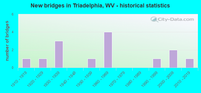
- New bridges - historical statistics
- 11910-1919
- 11920-1929
- 31930-1939
- 11950-1959
- 41960-1969
- 11990-1999
- 22000-2009
- 12010-2019

- Reconstructed bridges - Historical Statistics
- 11970-1979
- 31980-1989
- 11990-1999


- Bridge Condition - Deck
- 40.0%Good
- 10.0%Satisfactory
- 20.0%Fair
- 20.0%Poor
- 10.0%Serious

- Bridge Condition - Superstructure
- 18.2%Good
- 18.2%Satisfactory
- 27.3%Fair
- 27.3%Poor
- 9.1%Serious

- Bridge Condition - Substructure
- 20.0%Good
- 10.0%Satisfactory
- 60.0%Fair
- 10.0%Poor

- Bridge Condition - Channel
- 16.7%Very good
- 41.7%Good
- 16.7%Satisfactory
- 25.0%Fair
Find on map >> Show street view
Structure Number: 35A027, Location: 0.06 mi. East jct US 40 (Lat: 40.048700, Lng: -80.634261), Route carried "on" structure: County highway 39, Year Built: 1932, Status: Posted for load, Structure Length: 2.48m (8.14ft), Average Daily Traffic: 1,500 (year 2019), Truck Traffic: 7%, Average Future Daily Traffic: 1,830 (year 2039), Features Intersected: Little Wheeling Creek
Minimum Vertical Clearance: 30+ m (98+ ft), Kilometerpoint: 0.097, Lanes on structure: 2, Owner: State Highway Agency, Approaching Roadway Width: 2.4m (7.9ft), Skew: 1 degrees, Material/Design: Concrete, Design/Construction: Frame, Number Of Spans In Main Unit: 1, Length of Maximum Span: 21.3m (69.9ft), Curb or Sidewalk Widths: Left: 0.2m (0.7ft), Right: 1.6m (5.2ft), Curb-To-Curb Width: 7.3m (24.0ft), Out-to-Out Width: 9.8m (32.2ft)
Condition: Deck: Poor, Superstructure: Poor, Substructure: Fair, Channel: Good, Operating Rating: 37.2 metric tons, Method Used To Determine Operating Rating: Field evaluation and documented engineering judgment, Inventory Rating: 14.5 metric tons, Method Used To Determine Inventory Rating: Field evaluation and documented engineering judgment, Structural Evaluation: Meets minimum limits, Deck Geometry: Meets minimum limits, Waterway Adequacy: Equal to present desirable criteria, Approach Roadway Alignment: Equal to present minimum criteria, Length Of Structure Improvement: 3.26m (10.70ft), Designated Inspection Frequency: Every 24 months, Inspection Date: August 2020, Bridge Improvement Cost: $34,000, Roadway Improvement Cost: $33,000, Total Project Cost: $67,000 ( Estimate for 2018), Deck Structure Type: Concrete Cast-file-Place, Wearing Surface/Protective System: Wearing Surface: Bituminous
Find on map >> Show street view
Structure Number: 35A029, Location: 0.52 mi. East jct CR23/2 (Lat: 40.031819, Lng: -80.583200), Route carried "on" structure: County highway 39, Year Built: 1959, Year Reconstructed: 1988, Status: Open, Structure Length: 3.08m (10.10ft), Average Daily Traffic: 90 (year 2020), Truck Traffic: 7%, Average Future Daily Traffic: 110 (year 2040), Design Load: HS 20, Features Intersected: Middle Wheeling Creek
Minimum Vertical Clearance: 30+ m (98+ ft), Kilometerpoint: 6.276, Lanes on structure: 2, Owner: State Highway Agency, Approaching Roadway Width: 6.1m (20.0ft), Skew: 4 degrees, Material/Design: Steel, Design/Construction: Stringer/Multi-beam, Number Of Spans In Main Unit: 2, Length of Maximum Span: 14.8m (48.6ft), Curb-To-Curb Width: 5.2m (17.1ft), Out-to-Out Width: 6.1m (20.0ft)
Condition: Deck: Poor, Superstructure: Poor, Substructure: Poor, Channel: Fair, Operating Rating: 84.4 metric tons, Method Used To Determine Operating Rating: Load Factor (LF), Inventory Rating: 50.8 metric tons, Method Used To Determine Inventory Rating: Load Factor (LF), Structural Evaluation: Meets minimum limits, Deck Geometry: High priority of corrective action, Waterway Adequacy: Superior to present desirable criteria, Approach Roadway Alignment: Somewhat better than minimum adequacy, Length Of Structure Improvement: 3.93m (12.89ft), Designated Inspection Frequency: Every 24 months, Other Special Inspection Frequency: Every 12 months, Inspection Date: December 2021, Other Special Inspection Date: December 2021, Bridge Improvement Cost: $412,000, Roadway Improvement Cost: $408,000, Total Project Cost: $1,069,000 ( Estimate for 2020), Deck Structure Type: Closed Grating, Wearing Surface/Protective System: Wearing Surface: Other
Find on map >> Show street view
Structure Number: 35A039, Location: 0.01 mi. East jct CR25 (Lat: 40.048669, Lng: -80.642539), Route carried "on" structure: US 40, Year Built: 1934, Year Reconstructed: 2003, Status: Open, Structure Length: 1.20m (3.94ft), Average Daily Traffic: 7,700 (year 2020), Truck Traffic: 5%, Average Future Daily Traffic: 9,394 (year 2040), Features Intersected: Peters Run
Minimum Vertical Clearance: 30+ m (98+ ft), Kilometerpoint: 12.279, Lanes on structure: 3, Owner: State Highway Agency, Approaching Roadway Width: 11.9m (39.0ft), Material/Design: Concrete continuous, Design/Construction: Culvert, Number Of Spans In Main Unit: 2, Length of Maximum Span: 4.9m (16.1ft), Curb or Sidewalk Widths: Left: 0.0m, Right: 1.7m (5.6ft)
Condition: Channel: Satisfactory, Culverts: Satisfactory, Operating Rating: 63.5 metric tons, Method Used To Determine Operating Rating: Field evaluation and documented engineering judgment, Inventory Rating: 29.0 metric tons, Method Used To Determine Inventory Rating: Field evaluation and documented engineering judgment, Structural Evaluation: Equal to present minimum criteria, Waterway Adequacy: Equal to present desirable criteria, Approach Roadway Alignment: Better than present minimum criteria, Designated Inspection Frequency: Every 24 months, Inspection Date: May 2021
Find on map >> Show street view
Structure Number: 35A04, Location: 0.60 mi. East jct CR 8 (Lat: 40.057281, Lng: -80.619181), Route carried "on" structure: US 40, Year Built: 1991, Status: Open, Structure Length: 3.04m (9.97ft), Average Daily Traffic: 5,000 (year 2020), Truck Traffic: 5%, Average Future Daily Traffic: 6,750 (year 2040), Design Load: HS 25 or greater, Features Intersected: Little Wheeling Creek
Minimum Vertical Clearance: 30+ m (98+ ft), Kilometerpoint: 14.645, Lanes on structure: 2, Owner: State Highway Agency, Approaching Roadway Width: 11.6m (38.1ft), Skew: 4 degrees, Material/Design: Prestressed concrete, Design/Construction: Box Beam or Girders - Multiple, Number Of Spans In Main Unit: 1, Length of Maximum Span: 28.7m (94.2ft), Curb or Sidewalk Widths: Left: 0.8m (2.6ft), Right: 0.2m (0.7ft), Curb-To-Curb Width: 10.5m (34.4ft), Out-to-Out Width: 12.1m (39.7ft)
Condition: Deck: Satisfactory, Superstructure: Satisfactory, Substructure: Fair, Channel: Fair, Operating Rating: 82.5 metric tons, Method Used To Determine Operating Rating: Load Factor (LF), Inventory Rating: 49.9 metric tons, Method Used To Determine Inventory Rating: Load Factor (LF), Structural Evaluation: Somewhat better than minimum adequacy, Deck Geometry: Somewhat better than minimum adequacy, Waterway Adequacy: Equal to present minimum criteria, Approach Roadway Alignment: Equal to present minimum criteria, Length Of Structure Improvement: 3.81m (12.50ft), Designated Inspection Frequency: Every 24 months, Underwater Inspection Frequency: Every 60 months, Inspection Date: October 2021, Underwater Inspection Date: September 2020, Bridge Improvement Cost: $11,000, Roadway Improvement Cost: $10,000, Total Project Cost: $25,000 ( Estimate for 2019), Deck Structure Type: Other, Wearing Surface/Protective System: Wearing Surface: Bituminous, Deck Protection: Epoxy Coated Reinforcing
Find on map >> Show street view
Structure Number: 35A041, Location: 0.43 mi. West jct CR40/3 (Lat: 40.063611, Lng: -80.613711), Route carried "on" structure: US 40, Year Built: 1931, Status: Open, Structure Length: 2.44m (8.01ft), Average Daily Traffic: 4,500 (year 2020), Truck Traffic: 11%, Average Future Daily Traffic: 5,490 (year 2040), Features Intersected: Little Wheeling Creek
Minimum Vertical Clearance: 30+ m (98+ ft), Kilometerpoint: 15.514, Lanes on structure: 2, Owner: State Highway Agency, Approaching Roadway Width: 7.3m (24.0ft), Skew: 3 degrees, Material/Design: Concrete, Design/Construction: Arch - Deck, Number Of Spans In Main Unit: 1, Length of Maximum Span: 24.4m (80.1ft), Curb or Sidewalk Widths: Left: 1.5m (4.9ft), Right: 0.3m (1.0ft), Curb-To-Curb Width: 9.3m (30.5ft), Out-to-Out Width: 11.6m (38.1ft)
Condition: Superstructure: Poor, Channel: Satisfactory, Operating Rating: 49.9 metric tons, Method Used To Determine Operating Rating: Field evaluation and documented engineering judgment, Inventory Rating: 20.0 metric tons, Method Used To Determine Inventory Rating: Field evaluation and documented engineering judgment, Structural Evaluation: Meets minimum limits, Deck Geometry: Meets minimum limits, Waterway Adequacy: Equal to present minimum criteria, Approach Roadway Alignment: Somewhat better than minimum adequacy, Length Of Structure Improvement: 2.44m (8.01ft), Designated Inspection Frequency: Every 24 months, Inspection Date: September 2021, Bridge Improvement Cost: $24,000, Roadway Improvement Cost: $1,000, Total Project Cost: $40,000 ( Estimate for 2021), Deck Structure Type: Concrete Cast-file-Place
Find on map >> Show street view
Structure Number: 35A042, Location: 0.02 mi. West jct CR 40/3 (Lat: 40.065039, Lng: -80.606389), Route carried "on" structure: US 40, Year Built: 1922, Status: Open, Structure Length: 0.80m (2.62ft), Average Daily Traffic: 4,500 (year 2020), Truck Traffic: 5%, Average Future Daily Traffic: 5,490 (year 2040), Features Intersected: Gashell Run
Minimum Vertical Clearance: 30+ m (98+ ft), Kilometerpoint: 16.174, Lanes on structure: 3, Owner: State Highway Agency, Approaching Roadway Width: 15.9m (52.2ft), Skew: 2 degrees, Material/Design: Concrete, Design/Construction: Slab, Number Of Spans In Main Unit: 1, Length of Maximum Span: 7.0m (23.0ft), Curb-To-Curb Width: 14.9m (48.9ft), Out-to-Out Width: 16.8m (55.1ft)
Condition: Deck: Fair, Superstructure: Fair, Substructure: Fair, Channel: Fair, Operating Rating: 54.4 metric tons, Method Used To Determine Operating Rating: Field evaluation and documented engineering judgment, Inventory Rating: 24.5 metric tons, Method Used To Determine Inventory Rating: Field evaluation and documented engineering judgment, Structural Evaluation: Somewhat better than minimum adequacy, Deck Geometry: Equal to present minimum criteria, Waterway Adequacy: Equal to present minimum criteria, Approach Roadway Alignment: Equal to present desirable criteria, Length Of Structure Improvement: 0.79m (2.59ft), Designated Inspection Frequency: Every 24 months, Inspection Date: April 2021, Bridge Improvement Cost: $42,000, Roadway Improvement Cost: $25,000, Total Project Cost: $67,000 ( Estimate for 2021), Deck Structure Type: Other, Wearing Surface/Protective System: Wearing Surface: Bituminous
Find on map >> Show street view
Structure Number: 35A077, Location: 1.42 Mi. East Jct. US 40 (Lat: 40.044689, Lng: -80.630561), Route carried "on" structure: Interstate 70, Year Built: 1968, Year Reconstructed: 1981, Status: Open, Structure Length: 14.22m (46.65ft), Average Daily Traffic: 19,350 (year 2019), Truck Traffic: 28%, Average Future Daily Traffic: 28,832 (year 2039), Design Load: HS 20+Mod, Features Intersected: Middle Creek & CR 39
Minimum Vertical Clearance: 30+ m (98+ ft), Kilometerpoint: 10.847, Lanes on structure: 2, Lanes under structure: 2, Base Highway Network: Yes, Owner: State Highway Agency, Approaching Roadway Width: 11.3m (37.1ft), Skew: 4 degrees, Material/Design: Steel continuous, Design/Construction: Stringer/Multi-beam, Number Of Spans In Main Unit: 2, Number Of Approach Spans: 3, Length of Maximum Span: 33.5m (109.9ft), Curb or Sidewalk Widths: Left: 0.2m (0.7ft), Right: 0.2m (0.7ft), Curb-To-Curb Width: 12.5m (41.0ft), Out-to-Out Width: 13.6m (44.6ft)
Condition: Deck: Fair, Superstructure: Serious, Substructure: Fair, Channel: Very good, Operating Rating: 55.3 metric tons, Method Used To Determine Operating Rating: Load Factor (LF), Inventory Rating: 32.7 metric tons, Method Used To Determine Inventory Rating: Load Factor (LF), Structural Evaluation: High priority of corrective action, Deck Geometry: Better than present minimum criteria, Underclear: Equal to present minimum criteria, Waterway Adequacy: Superior to present desirable criteria, Approach Roadway Alignment: Better than present minimum criteria, Length Of Structure Improvement: 14.20m (46.59ft), Designated Inspection Frequency: Every 24 months, Other Special Inspection Frequency: Every 12 months, Inspection Date: August 2020, Other Special Inspection Date: August 2021, Bridge Improvement Cost: $573,000, Roadway Improvement Cost: $1,000, Total Project Cost: $574,000 ( Estimate for 2019), Deck Structure Type: Concrete Cast-file-Place, Wearing Surface/Protective System: Wearing Surface: Monolithic Concrete, Deck Protection: Epoxy Coated Reinforcing
Find on map >> Show street view
Structure Number: 35A078, Location: 1.42 mi. East jct US 40 (Lat: 40.044489, Lng: -80.630550), Route carried "on" structure: Interstate 70, Year Built: 1968, Year Reconstructed: 1980, Status: Open, Structure Length: 12.63m (41.44ft), Average Daily Traffic: 25,683 (year 2017), Truck Traffic: 28%, Average Future Daily Traffic: 41,093 (year 2037), Design Load: HS 20, Features Intersected: Middle Creek & CR39
Minimum Vertical Clearance: 30+ m (98+ ft), Kilometerpoint: 10.847, Lanes on structure: 2, Lanes under structure: 2, Base Highway Network: Yes, Owner: State Highway Agency, Approaching Roadway Width: 12.2m (40.0ft), Skew: 4 degrees, Material/Design: Steel continuous, Design/Construction: Stringer/Multi-beam, Number Of Spans In Main Unit: 2, Number Of Approach Spans: 2, Length of Maximum Span: 33.5m (109.9ft), Curb or Sidewalk Widths: Left: 0.2m (0.7ft), Right: 0.2m (0.7ft), Curb-To-Curb Width: 12.5m (41.0ft), Out-to-Out Width: 13.6m (44.6ft)
Condition: Deck: Good, Superstructure: Fair, Substructure: Fair, Channel: Very good, Operating Rating: 57.1 metric tons, Method Used To Determine Operating Rating: Load Factor (LF), Inventory Rating: 34.5 metric tons, Method Used To Determine Inventory Rating: Load Factor (LF), Structural Evaluation: Somewhat better than minimum adequacy, Deck Geometry: Better than present minimum criteria, Underclear: Somewhat better than minimum adequacy, Waterway Adequacy: Equal to present desirable criteria, Approach Roadway Alignment: Equal to present desirable criteria, Length Of Structure Improvement: 12.62m (41.40ft), Designated Inspection Frequency: Every 24 months, Other Special Inspection Frequency: Every 12 months, Inspection Date: August 2020, Other Special Inspection Date: August 2021, Bridge Improvement Cost: $509,000, Roadway Improvement Cost: $1,000, Total Project Cost: $510,000 ( Estimate for 2020), Deck Structure Type: Concrete Cast-file-Place, Wearing Surface/Protective System: Wearing Surface: Monolithic Concrete, Deck Protection: Epoxy Coated Reinforcing
Find on map >> Show street view
Structure Number: 35A103, Location: 0.01 mi. West jct CR39 (Lat: 40.047131, Lng: -80.632981), Route carried "on" structure: County highway 398, Year Built: 1919, Year Reconstructed: 1986, Status: Open, Structure Length: 1.97m (6.46ft), Average Daily Traffic: 50 (year 2020), Truck Traffic: 7%, Average Future Daily Traffic: 61 (year 2040), Features Intersected: Middle Wheeling Creek, Facility Carried by Structure: County Route 39/8
Minimum Vertical Clearance: 30+ m (98+ ft), Kilometerpoint: 0.016, Lanes on structure: 1, Owner: State Highway Agency, Approaching Roadway Width: 10.4m (34.1ft), Material/Design: Steel, Design/Construction: Stringer/Multi-beam, Number Of Spans In Main Unit: 1, Number Of Approach Spans: 1, Length of Maximum Span: 11.4m (37.4ft), Curb-To-Curb Width: 4.5m (14.8ft), Out-to-Out Width: 4.8m (15.7ft)
Condition: Deck: Serious, Superstructure: Fair, Substructure: Fair, Channel: Good, Operating Rating: 63.5 metric tons, Method Used To Determine Operating Rating: Load Factor (LF), Inventory Rating: 38.1 metric tons, Method Used To Determine Inventory Rating: Load Factor (LF), Structural Evaluation: Somewhat better than minimum adequacy, Deck Geometry: Equal to present minimum criteria, Waterway Adequacy: Equal to present desirable criteria, Approach Roadway Alignment: Somewhat better than minimum adequacy, Length Of Structure Improvement: 2.56m (8.40ft), Designated Inspection Frequency: Every 24 months, Inspection Date: June 2021, Bridge Improvement Cost: $174,000, Roadway Improvement Cost: $168,000, Total Project Cost: $342,000 ( Estimate for 2019), Deck Structure Type: Concrete Cast-file-Place, Wearing Surface/Protective System: Wearing Surface: Bituminous
Find on map >> Show street view
Structure Number: 35A135, Location: 0.21 mi. West jct CR 27 (Lat: 40.070931, Lng: -80.600250), Route carried "on" structure: US 40, Year Built: 2000, Status: Open, Structure Length: 2.30m (7.55ft), Average Daily Traffic: 3,923 (year 2017), Truck Traffic: 5%, Average Future Daily Traffic: 5,296 (year 2037), Design Load: HS 25 or greater, Features Intersected: Little Wheeling Creek
Minimum Vertical Clearance: 30+ m (98+ ft), Kilometerpoint: 17.156, Lanes on structure: 2, Owner: State Highway Agency, Approaching Roadway Width: 10.7m (35.1ft), Skew: 3 degrees, Material/Design: Concrete, Design/Construction: Stringer/Multi-beam, Number Of Spans In Main Unit: 1, Length of Maximum Span: 22.0m (72.2ft), Curb-To-Curb Width: 10.3m (33.8ft), Out-to-Out Width: 11.3m (37.1ft)
Condition: Deck: Good, Superstructure: Good, Substructure: Good, Channel: Good, Operating Rating: 81.6 metric tons, Method Used To Determine Operating Rating: Load Factor (LF), Inventory Rating: 49.0 metric tons, Method Used To Determine Inventory Rating: Load Factor (LF), Structural Evaluation: Better than present minimum criteria, Deck Geometry: Meets minimum limits, Waterway Adequacy: Superior to present desirable criteria, Approach Roadway Alignment: Equal to present desirable criteria, Length Of Structure Improvement: 2.32m (7.61ft), Designated Inspection Frequency: Every 48 months, Inspection Date: January 2019, Bridge Improvement Cost: $78,000, Roadway Improvement Cost: $5,000, Total Project Cost: $83,000 ( Estimate for 2019), Deck Structure Type: Concrete Cast-file-Place, Wearing Surface/Protective System: Wearing Surface: Monolithic Concrete, Deck Protection: Epoxy Coated Reinforcing
Find on map >> Show street view
Structure Number: 35A139, Location: 0.10 mi. West jct CR25 (Lat: 40.048200, Lng: -80.643339), Route carried "on" structure: US 40, Year Built: 2005, Status: Open, Structure Length: 7.67m (25.16ft), Average Daily Traffic: 11,900 (year 2020), Truck Traffic: 5%, Average Future Daily Traffic: 14,518 (year 2040), Design Load: HS 25 or greater, Features Intersected: Little Wheeling Creek
Minimum Vertical Clearance: 30+ m (98+ ft), Kilometerpoint: 12.102, Lanes on structure: 3, Owner: State Highway Agency, Approaching Roadway Width: 13.1m (43.0ft), Skew: 4 degrees, Material/Design: Prestressed concrete, Design/Construction: Stringer/Multi-beam, Number Of Spans In Main Unit: 2, Length of Maximum Span: 37.9m (124.3ft), Curb or Sidewalk Widths: Left: 0.0m, Right: 1.5m (4.9ft), Curb-To-Curb Width: 12.0m (39.4ft), Out-to-Out Width: 14.2m (46.6ft)
Condition: Deck: Good, Superstructure: Satisfactory, Substructure: Good, Channel: Good, Operating Rating: 88.9 metric tons, Method Used To Determine Operating Rating: Load Factor (LF), Inventory Rating: 55.3 metric tons, Method Used To Determine Inventory Rating: Load Factor (LF), Structural Evaluation: Equal to present minimum criteria, Deck Geometry: Meets minimum limits, Waterway Adequacy: Equal to present desirable criteria, Approach Roadway Alignment: Equal to present desirable criteria, Designated Inspection Frequency: Every 24 months, Inspection Date: October 2021, Deck Structure Type: Concrete Cast-file-Place, Wearing Surface/Protective System: Wearing Surface: Monolithic Concrete, Deck Protection: Epoxy Coated Reinforcing
Find on map >> Show street view
Structure Number: 35A144, Location: 0.03 mi. West jct CR 23/2 (Lat: 40.037181, Lng: -80.595489), Route carried "on" structure: County highway 39, Year Built: 2012, Status: Open, Structure Length: 3.12m (10.24ft), Average Daily Traffic: 400 (year 2019), Truck Traffic: 7%, Average Future Daily Traffic: 488 (year 2039), Design Load: HL 93, Features Intersected: Middle Wheeling Creek
Minimum Vertical Clearance: 30+ m (98+ ft), Kilometerpoint: 5.391, Lanes on structure: 2, Owner: State Highway Agency, Approaching Roadway Width: 7.3m (24.0ft), Material/Design: Prestressed concrete, Design/Construction: Box Beam or Girders - Multiple, Number Of Spans In Main Unit: 2, Length of Maximum Span: 14.3m (46.9ft), Curb-To-Curb Width: 7.4m (24.3ft), Out-to-Out Width: 7.5m (24.6ft)
Condition: Deck: Good, Superstructure: Good, Substructure: Satisfactory, Channel: Good, Operating Rating: 67.1 metric tons, Method Used To Determine Operating Rating: Load and Resistance Factor (LRFR), Inventory Rating: 52.6 metric tons, Method Used To Determine Inventory Rating: Load and Resistance Factor (LRFR), Structural Evaluation: Equal to present minimum criteria, Deck Geometry: Somewhat better than minimum adequacy, Waterway Adequacy: Meets minimum limits, Approach Roadway Alignment: Equal to present minimum criteria, Designated Inspection Frequency: Every 48 months, Inspection Date: August 2020, Deck Structure Type: Concrete Precast Panels, Wearing Surface/Protective System: Wearing Surface: Bituminous
Find on map >> Show street view
Structure Number: 35A077, Location: 1.42 Mi. East Jct. US 40 (Lat: 40.044539, Lng: -80.630569), Route carried "under" structure: County highway 39, Year Built: 1968, Structure Length: 0. m, Average Daily Traffic: 1,450 (year 0008), Truck Traffic: 7%, Features Intersected: Middle Creek & CR 39, Facility Carried by Structure: Interstate 70
Minimum Vertical Clearance: 12.19m (39.99ft), Kilometerpoint: 0.676, Lanes on structure: 2, Lanes under structure: 2, Length of Maximum Span: 33.5m (109.9ft)
Find on map >> Show street view
Structure Number: 35A078, Location: 1.42 mi. East jct US 40 (Lat: 40.044419, Lng: -80.630419), Route carried "under" structure: County highway 3900, Year Built: 1968, Structure Length: 0. m, Average Daily Traffic: 975 (year 0015), Truck Traffic: 7%, Features Intersected: Middle Creek & CR39, Facility Carried by Structure: Interstate 70
Minimum Vertical Clearance: 12.19m (39.99ft), Kilometerpoint: 0.676, Lanes on structure: 2, Lanes under structure: 2, Length of Maximum Span: 33.5m (109.9ft)