Bridge Statistics for Triangle, New York (NY)
Condition, Traffic, Stress, Structural Evaluation, Project Costs
- National Bridge Inventory (NBI) Statistics
- 11Number of bridges
- 79ft / 24.2mTotal length
- $11,396,000Total costs
- 50,063Total average daily traffic
- 6,890Total average daily truck traffic
- National Bridge Inventory (NBI) Registered Bridges for Triangle
- No street view available for this location
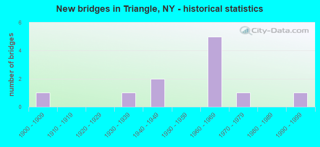
- New bridges - historical statistics
- 11900-1909
- 11930-1939
- 21940-1949
- 51960-1969
- 11970-1979
- 11990-1999

- Reconstructed bridges - Historical Statistics
- 11980-1989
- 01990-1999
- 22000-2009
- 12010-2019
- 12020-2022


- Bridge Condition - Deck
- 16.7%Excellent
- 33.3%Good
- 50.0%Satisfactory

- Bridge Condition - Superstructure
- 57.1%Good
- 14.3%Satisfactory
- 28.6%Fair

- Bridge Condition - Substructure
- 42.9%Good
- 28.6%Satisfactory
- 14.3%Fair
- 14.3%Poor

- Bridge Condition - Channel
- 28.6%Good
- 57.1%Satisfactory
- 14.3%Fair

- Bridge Condition - Culverts
- 50.0%Satisfactory
- 50.0%Fair
Find on map >> Show street view
Structure Number: 1008331, Location: 1.3 MI N JCT RTS I-81+26 (Lat: 42.338442, Lng: -75.978561), Route carried "on" structure: Interstate 81, Year Built: 1969, Year Reconstructed: 2008, Status: Open, Structure Length: 4.42m (14.50ft), Average Daily Traffic: 10,338 (year 2011), Truck Traffic: 36%, Average Future Daily Traffic: 14,473 (year 2031), Design Load: HS 20+Mod, Features Intersected: RTE 11
Minimum Vertical Clearance: 30+ m (98+ ft), Kilometerpoint: 48.898, Lanes on structure: 2, Lanes under structure: 2, Base Highway Network: Yes, Owner: State Highway Agency, Approaching Roadway Width: 11.9m (39.0ft), Skew: 2 degrees, Material/Design: Steel, Design/Construction: Stringer/Multi-beam, Number Of Spans In Main Unit: 3, Length of Maximum Span: 16.1m (52.8ft), Curb-To-Curb Width: 11.4m (37.4ft), Out-to-Out Width: 12.6m (41.3ft)
Condition: Deck: Satisfactory, Superstructure: Good, Substructure: Good, Operating Rating: 93.4 metric tons, Method Used To Determine Operating Rating: Load Factor (LF), Inventory Rating: 55.3 metric tons, Method Used To Determine Inventory Rating: Load Factor (LF), Structural Evaluation: Better than present minimum criteria, Deck Geometry: Somewhat better than minimum adequacy, Underclear: Meets minimum limits, Approach Roadway Alignment: Equal to present desirable criteria, Length Of Structure Improvement: 4.41m (14.47ft), Designated Inspection Frequency: Every 24 months, Inspection Date: May 2020, Bridge Improvement Cost: $1,296,000, Roadway Improvement Cost: $759,000, Total Project Cost: $2,054,000 ( Estimate for 2021), Deck Structure Type: Concrete Cast-file-Place, Wearing Surface/Protective System: Wearing Surface: Integral Concrete
Find on map >> Show street view
Structure Number: 1008332, Location: 1.3 MI N JCT RTS I-81+26 (Lat: 42.338333, Lng: -75.978339), Route carried "on" structure: Interstate 81, Year Built: 1969, Year Reconstructed: 2008, Status: Open, Structure Length: 4.36m (14.30ft), Average Daily Traffic: 7,914 (year 2019), Truck Traffic: 30%, Average Future Daily Traffic: 9,425 (year 2040), Design Load: HS 20+Mod, Features Intersected: RTE 11
Minimum Vertical Clearance: 30+ m (98+ ft), Kilometerpoint: 48.881, Lanes on structure: 2, Lanes under structure: 2, Base Highway Network: Yes, Owner: State Highway Agency, Approaching Roadway Width: 11.6m (38.1ft), Skew: 2 degrees, Material/Design: Steel, Design/Construction: Stringer/Multi-beam, Number Of Spans In Main Unit: 3, Length of Maximum Span: 16.1m (52.8ft), Curb or Sidewalk Widths: Left: 0.5m (1.6ft), Right: 0.5m (1.6ft), Curb-To-Curb Width: 11.2m (36.7ft), Out-to-Out Width: 12.7m (41.7ft)
Condition: Deck: Satisfactory, Superstructure: Good, Substructure: Good, Operating Rating: 72.6 metric tons, Method Used To Determine Operating Rating: Load Factor (LF), Inventory Rating: 43.5 metric tons, Method Used To Determine Inventory Rating: Load Factor (LF), Structural Evaluation: Better than present minimum criteria, Deck Geometry: Somewhat better than minimum adequacy, Underclear: High priority of corrective action, Approach Roadway Alignment: Equal to present desirable criteria, Length Of Structure Improvement: 4.35m (14.27ft), Designated Inspection Frequency: Every 24 months, Inspection Date: May 2020, Bridge Improvement Cost: $1,290,000, Roadway Improvement Cost: $755,000, Total Project Cost: $2,045,000 ( Estimate for 2021), Deck Structure Type: Concrete Cast-file-Place, Wearing Surface/Protective System: Wearing Surface: Monolithic Concrete
Find on map >> Show street view
Structure Number: 101861, Location: 1.7 MI N JCT RTS 26 + 206 (Lat: 42.352183, Lng: -75.967808), Route carried "on" structure: State highway 26, Year Built: 1942, Status: Open, Structure Length: 1.58m (5.18ft), Average Daily Traffic: 2,417 (year 2020), Truck Traffic: 12%, Average Future Daily Traffic: 2,521 (year 2040), Features Intersected: PAGE BROOK
Minimum Vertical Clearance: 30+ m (98+ ft), Kilometerpoint: 48.045, Lanes on structure: 2, Base Highway Network: Yes, Owner: State Highway Agency, Approaching Roadway Width: 11.3m (37.1ft), Material/Design: Concrete, Design/Construction: Arch - Deck, Number Of Spans In Main Unit: 1, Length of Maximum Span: 14.0m (45.9ft), Curb-To-Curb Width: 11.6m (38.1ft), Out-to-Out Width: 14.9m (48.9ft)
Condition: Superstructure: Fair, Substructure: Fair, Channel: Good, Operating Rating: 55.1 metric tons, Method Used To Determine Operating Rating: Field evaluation and documented engineering judgment, Inventory Rating: 14.2 metric tons, Method Used To Determine Inventory Rating: Field evaluation and documented engineering judgment, Structural Evaluation: Meets minimum limits, Deck Geometry: Somewhat better than minimum adequacy, Waterway Adequacy: Equal to present minimum criteria, Approach Roadway Alignment: Equal to present desirable criteria, Length Of Structure Improvement: 1.58m (5.18ft), Designated Inspection Frequency: Every 24 months, Inspection Date: May 2021, Bridge Improvement Cost: $472,000, Roadway Improvement Cost: $276,000, Total Project Cost: $748,000 ( Estimate for 2021), Wearing Surface/Protective System: Wearing Surface: Bituminous
Find on map >> Show street view
Structure Number: 104035, Location: 4.4 MI E JCT SH 206 & SH (Lat: 42.338475, Lng: -75.888083), Route carried "on" structure: State highway 206, Year Built: 1996, Status: Open, Structure Length: 2.83m (9.28ft), Average Daily Traffic: 2,590 (year 2017), Truck Traffic: 9%, Average Future Daily Traffic: 2,606 (year 2040), Design Load: HS 25 or greater, Features Intersected: TICKNOR BROOK
Minimum Vertical Clearance: 30+ m (98+ ft), Kilometerpoint: 7.031, Lanes on structure: 2, Base Highway Network: Yes, Owner: State Highway Agency, Approaching Roadway Width: 11.0m (36.1ft), Skew: 4 degrees, Material/Design: Steel, Design/Construction: Stringer/Multi-beam, Number Of Spans In Main Unit: 1, Length of Maximum Span: 27.4m (89.9ft), Curb-To-Curb Width: 11.0m (36.1ft), Out-to-Out Width: 11.6m (38.1ft)
Condition: Deck: Satisfactory, Superstructure: Good, Substructure: Good, Channel: Satisfactory, Operating Rating: 87.1 metric tons, Method Used To Determine Operating Rating: Load Factor (LF), Inventory Rating: 51.7 metric tons, Method Used To Determine Inventory Rating: Load Factor (LF), Structural Evaluation: Better than present minimum criteria, Deck Geometry: Somewhat better than minimum adequacy, Waterway Adequacy: Somewhat better than minimum adequacy, Approach Roadway Alignment: Equal to present desirable criteria, Length Of Structure Improvement: 2.83m (9.28ft), Designated Inspection Frequency: Every 24 months, Inspection Date: May 2020, Bridge Improvement Cost: $807,000, Roadway Improvement Cost: $473,000, Total Project Cost: $1,280,000 ( Estimate for 2021), Deck Structure Type: Concrete Cast-file-Place, Wearing Surface/Protective System: Wearing Surface: Integral Concrete, Deck Protection: Epoxy Coated Reinforcing
Find on map >> Show street view
Structure Number: 104036, Location: 4.7 MI E JCT RTS 206+26 (Lat: 42.339464, Lng: -75.882669), Route carried "on" structure: State highway 206, Year Built: 1936, Year Reconstructed: 1988, Status: Open, Structure Length: 1.58m (5.18ft), Average Daily Traffic: 2,260 (year 2020), Truck Traffic: 11%, Average Future Daily Traffic: 2,274 (year 2040), Design Load: H 20, Features Intersected: HALFWAY BROOK
Minimum Vertical Clearance: 30+ m (98+ ft), Kilometerpoint: 7.498, Lanes on structure: 2, Base Highway Network: Yes, Owner: State Highway Agency, Approaching Roadway Width: 10.1m (33.1ft), Skew: 2 degrees, Material/Design: Steel, Design/Construction: Stringer/Multi-beam, Number Of Spans In Main Unit: 1, Length of Maximum Span: 13.7m (44.9ft), Curb-To-Curb Width: 11.0m (36.1ft), Out-to-Out Width: 11.6m (38.1ft)
Condition: Deck: Good, Superstructure: Satisfactory, Substructure: Satisfactory, Channel: Satisfactory, Operating Rating: 50.5 metric tons, Method Used To Determine Operating Rating: Load and Resistance Factor Rating (LRFR) rating reported by rating factor(RF) method using HL-93 loadings, Inventory Rating: 38.6 metric tons, Method Used To Determine Inventory Rating: Load and Resistance Factor Rating (LRFR) rating reported by rating factor(RF) method using HL-93 loadings, Structural Evaluation: Equal to present minimum criteria, Deck Geometry: Somewhat better than minimum adequacy, Waterway Adequacy: Somewhat better than minimum adequacy, Approach Roadway Alignment: Equal to present desirable criteria, Length Of Structure Improvement: 1.58m (5.18ft), Designated Inspection Frequency: Every 24 months, Inspection Date: April 2021, Bridge Improvement Cost: $604,000, Roadway Improvement Cost: $354,000, Total Project Cost: $958,000 ( Estimate for 2021), Deck Structure Type: Concrete Cast-file-Place, Wearing Surface/Protective System: Wearing Surface: Integral Concrete, Deck Protection: Epoxy Coated Reinforcing
Find on map >> Show street view
Structure Number: 334968, Location: 0.1 MI WEST OF LISLE (Lat: 42.396708, Lng: -75.959906), Route carried "on" structure: County highway , Year Built: 1902, Year Reconstructed: 2018, Status: Posted for load, Structure Length: 5.67m (18.60ft), Average Daily Traffic: 250 (year 2020), Average Future Daily Traffic: 350 (year 2040), Features Intersected: OTSELIC RIVER, Facility Carried by Structure: UPPER LISLE ROAD
Minimum Vertical Clearance: 4.21m (13.81ft), Kilometerpoint: 0.193, Lanes on structure: 1, Owner: County Highway Agency, Approaching Roadway Width: 4.6m (15.1ft), Material/Design: Steel, Design/Construction: Truss - Thru, Number Of Spans In Main Unit: 1, Length of Maximum Span: 55.2m (181.1ft), Curb-To-Curb Width: 4.6m (15.1ft), Out-to-Out Width: 4.9m (16.1ft)
Condition: Deck: Excellent, Superstructure: Fair, Substructure: Poor, Channel: Satisfactory, Operating Rating: 10.0 metric tons, Method Used To Determine Operating Rating: Load Factor (LF), Inventory Rating: 5.4 metric tons, Method Used To Determine Inventory Rating: Load Factor (LF), Structural Evaluation: High priority of corrective action, Deck Geometry: High priority of replacement, Waterway Adequacy: Somewhat better than minimum adequacy, Approach Roadway Alignment: High priority of corrective action, Bridge Posting: Required (Relationship of Operating Rating to Maximum Legal Load: > 39.9% below), Length Of Structure Improvement: 5.66m (18.57ft), Designated Inspection Frequency: Every 12 months, Critical Feature Inspection Frequency: Every 12 months, Underwater Inspection Frequency: Every 60 months, Inspection Date: October 2021, Critical Feature Inspection Date: October 2021, Underwater Inspection Date: June 2021, Bridge Improvement Cost: $1,962,000, Roadway Improvement Cost: $1,149,000, Total Project Cost: $3,111,000 ( Estimate for 2021), Deck Structure Type: Open Grating, Wearing Surface/Protective System: Wearing Surface: Other
Find on map >> Show street view
Structure Number: 334969, Location: 3.0 MI NE WHITNEY POINT (Lat: 42.371039, Lng: -75.935925), Route carried "on" structure: County highway , Year Built: 1943, Status: Open, Structure Length: 1.04m (3.41ft), Average Daily Traffic: 286 (year 2016), Truck Traffic: 8%, Average Future Daily Traffic: 400 (year 2036), Features Intersected: PAGE BROOK, Facility Carried by Structure: PAGE BROOK ROAD
Minimum Vertical Clearance: 30+ m (98+ ft), Kilometerpoint: 3.298, Lanes on structure: 2, Owner: County Highway Agency, Approaching Roadway Width: 6.1m (20.0ft), Skew: 3 degrees, Material/Design: Steel, Design/Construction: Stringer/Multi-beam, Number Of Spans In Main Unit: 1, Length of Maximum Span: 9.7m (31.8ft), Curb-To-Curb Width: 7.4m (24.3ft), Out-to-Out Width: 8.3m (27.2ft)
Condition: Deck: Good, Superstructure: Good, Substructure: Satisfactory, Channel: Good, Operating Rating: 39.9 metric tons, Method Used To Determine Operating Rating: Load Factor (LF), Inventory Rating: 23.6 metric tons, Method Used To Determine Inventory Rating: Load Factor (LF), Structural Evaluation: Equal to present minimum criteria, Deck Geometry: Somewhat better than minimum adequacy, Waterway Adequacy: Equal to present desirable criteria, Approach Roadway Alignment: Meets minimum limits, Length Of Structure Improvement: 1.03m (3.38ft), Designated Inspection Frequency: Every 24 months, Inspection Date: June 2020, Bridge Improvement Cost: $402,000, Roadway Improvement Cost: $236,000, Total Project Cost: $638,000 ( Estimate for 2021), Deck Structure Type: Concrete Cast-file-Place, Wearing Surface/Protective System: Wearing Surface: Bituminous
Find on map >> Show street view
Structure Number: 33497, Location: 3 MIL. E. OF KILLAWOG (Lat: 42.403400, Lng: -75.974969), Route carried "on" structure: Other road , Year Built: 1971, Status: Open, Structure Length: 1.25m (4.10ft), Average Daily Traffic: 78 (year 2018), Average Future Daily Traffic: 109 (year 2038), Design Load: H 20, Features Intersected: MERRILL CREEK, Facility Carried by Structure: BASSETT RD
Minimum Vertical Clearance: 30+ m (98+ ft), Kilometerpoint: 0.129, Lanes on structure: 2, Owner: County Highway Agency, Approaching Roadway Width: 5.5m (18.0ft), Skew: 2 degrees, Material/Design: Steel, Design/Construction: Culvert, Number Of Spans In Main Unit: 2, Length of Maximum Span: 5.1m (16.7ft)
Condition: Channel: Fair, Culverts: Fair, Operating Rating: 72.2 metric tons, Method Used To Determine Operating Rating: Field evaluation and documented engineering judgment, Inventory Rating: 19.6 metric tons, Method Used To Determine Inventory Rating: Field evaluation and documented engineering judgment, Structural Evaluation: Somewhat better than minimum adequacy, Waterway Adequacy: Equal to present desirable criteria, Approach Roadway Alignment: Meets minimum limits, Length Of Structure Improvement: 1.24m (4.07ft), Designated Inspection Frequency: Every 24 months, Inspection Date: April 2020, Bridge Improvement Cost: $121,000, Roadway Improvement Cost: $71,000, Total Project Cost: $192,000 ( Estimate for 2021)
Find on map >> Show street view
Structure Number: 334972, Location: 1.0 MI N OF WHITNEY POINT (Lat: 42.350692, Lng: -75.970772), Route carried "on" structure: Federal lands road , Year Built: 1969, Year Reconstructed: 2020, Status: Open, Structure Length: 1.43m (4.69ft), Average Daily Traffic: 54 (year 2019), Truck Traffic: 5%, Average Future Daily Traffic: 76 (year 2039), Features Intersected: PAGE BROOK, Facility Carried by Structure: DORCHESTER PARK RO
Minimum Vertical Clearance: 30+ m (98+ ft), Kilometerpoint: 0.064, Lanes on structure: 2, Owner: County Highway Agency, Approaching Roadway Width: 6.7m (22.0ft), Material/Design: Steel, Design/Construction: Culvert, Number Of Spans In Main Unit: 2, Length of Maximum Span: 6.7m (22.0ft), Curb or Sidewalk Widths: Left: 1.8m (5.9ft), Right: 0.0m, Curb-To-Curb Width: 6.9m (22.6ft), Out-to-Out Width: 9.2m (30.2ft)
Condition: Channel: Satisfactory, Culverts: Satisfactory, Operating Rating: 32.7 metric tons, Method Used To Determine Operating Rating: Load Factor (LF), Inventory Rating: 32.7 metric tons, Method Used To Determine Inventory Rating: Load Factor (LF), Structural Evaluation: Equal to present minimum criteria, Deck Geometry: Somewhat better than minimum adequacy, Waterway Adequacy: Equal to present desirable criteria, Approach Roadway Alignment: Equal to present minimum criteria, Length Of Structure Improvement: 1.43m (4.69ft), Designated Inspection Frequency: Every 24 months, Inspection Date: July 2020, Bridge Improvement Cost: $233,000, Roadway Improvement Cost: $137,000, Total Project Cost: $370,000 ( Estimate for 2021)
Find on map >> Show street view
Structure Number: 1008331, Location: 1.3 MI N JCT RTS I-81+26 (Lat: 42.338442, Lng: -75.978561), Route carried "under" structure: US 11, Year Built: 1969, Structure Length: 0. m, Average Daily Traffic: 11,938 (year 1999), Features Intersected: RTE 11, Facility Carried by Structure: RTE I81
Minimum Vertical Clearance: 5.08m (16.67ft), Kilometerpoint: 27.546, Lanes on structure: 2, Lanes under structure: 2, Material/Design: Steel, Design/Construction: Stringer/Multi-beam, Length of Maximum Span: 16.1m (52.8ft)
Find on map >> Show street view
Structure Number: 1008332, Location: 1.3 MI N JCT RTS I-81+26 (Lat: 42.338333, Lng: -75.978339), Route carried "under" structure: US 11, Year Built: 1969, Structure Length: 0. m, Average Daily Traffic: 11,938 (year 1999), Features Intersected: RTE 11, Facility Carried by Structure: RTE I81
Minimum Vertical Clearance: 4.88m (16.01ft), Kilometerpoint: 27.546, Lanes on structure: 2, Lanes under structure: 2, Material/Design: Steel, Design/Construction: Stringer/Multi-beam, Length of Maximum Span: 16.1m (52.8ft)