Bridge Statistics for Troutdale, Oregon (OR)
Condition, Traffic, Stress, Structural Evaluation, Project Costs
- National Bridge Inventory (NBI) Statistics
- 20Number of bridges
- 315ft / 95.6mTotal length
- $4,447,000Total costs
- 172,857Total average daily traffic
- 28,986Total average daily truck traffic
- National Bridge Inventory (NBI) Registered Bridges for Troutdale
- No street view available for this location
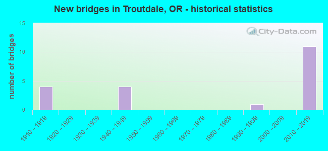
- New bridges - historical statistics
- 41910-1919
- 41940-1949
- 11990-1999
- 112010-2019
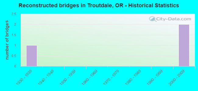
- Reconstructed bridges - Historical Statistics
- 11930-1939
- 01940-1949
- 01950-1959
- 01960-1969
- 01970-1979
- 01980-1989
- 01990-1999
- 22000-2009
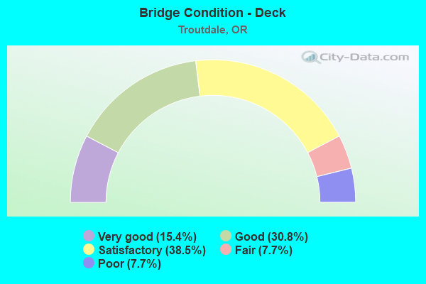
- Bridge Condition - Deck
- 15.4%Very good
- 30.8%Good
- 38.5%Satisfactory
- 7.7%Fair
- 7.7%Poor
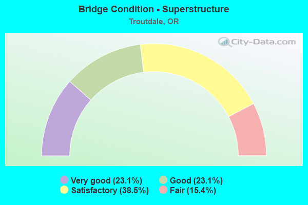
- Bridge Condition - Superstructure
- 23.1%Very good
- 23.1%Good
- 38.5%Satisfactory
- 15.4%Fair
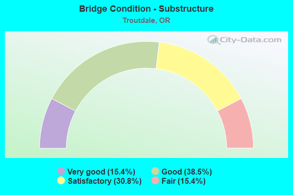
- Bridge Condition - Substructure
- 15.4%Very good
- 38.5%Good
- 30.8%Satisfactory
- 15.4%Fair
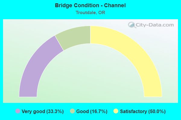
- Bridge Condition - Channel
- 33.3%Very good
- 16.7%Good
- 50.0%Satisfactory
Find on map >> Show street view
Structure Number: 2019 125 00185, Location: AT TROUTDALE (Lat: 45.538431, Lng: -122.376681), Route carried "on" structure: State highway 30, Year Built: 1912, Status: Posted for load, Structure Length: 11.16m (36.61ft), Average Daily Traffic: 1,809 (year 2020), Truck Traffic: 13%, Average Future Daily Traffic: 3,700 (year 2040), Design Load: HS 15, Features Intersected: Sandy River, Facility Carried by Structure: Hwy 100
Minimum Vertical Clearance: 4.90m (16.08ft), Kilometerpoint: 0.048, Lanes on structure: 2, Base Highway Network: Yes, Owner: State Highway Agency, Approaching Roadway Width: 5.3m (17.4ft), Material/Design: Steel, Design/Construction: Truss - Thru, Number Of Spans In Main Unit: 2, Number Of Approach Spans: 1, Length of Maximum Span: 49.7m (163.1ft), Curb or Sidewalk Widths: Left: 0.0m, Right: 1.0m (3.3ft), Curb-To-Curb Width: 5.3m (17.4ft), Out-to-Out Width: 7.2m (23.6ft)
Condition: Deck: Fair, Superstructure: Fair, Substructure: Fair, Channel: Satisfactory, Operating Rating: 10.4 metric tons, Method Used To Determine Operating Rating: Load and Resistance Factor Rating (LRFR) rating reported by rating factor(RF) method using HL-93 loadings, Inventory Rating: 8.1 metric tons, Method Used To Determine Inventory Rating: Load and Resistance Factor Rating (LRFR) rating reported by rating factor(RF) method using HL-93 loadings, Structural Evaluation: High priority of corrective action, Deck Geometry: High priority of replacement, Waterway Adequacy: Equal to present desirable criteria, Approach Roadway Alignment: High priority of corrective action, Bridge Posting: Required (Relationship of Operating Rating to Maximum Legal Load: > 39.9% below), Length Of Structure Improvement: 11.10m (36.42ft), Designated Inspection Frequency: Every 12 months, Critical Feature Inspection Frequency: Every 12 months, Inspection Date: September 2021, Critical Feature Inspection Date: September 2021, Bridge Improvement Cost: $1,166,000, Roadway Improvement Cost: $117,000, Total Project Cost: $1,865,000, Deck Structure Type: Concrete Cast-file-Place, Wearing Surface/Protective System: Wearing Surface: Monolithic Concrete
Find on map >> Show street view
Structure Number: 4522 125 00174, Location: AT TROUTDALE (Lat: 45.537450, Lng: -122.379339), Route carried "on" structure: County highway 917, Year Built: 1912, Status: Posted for load, Structure Length: 1.22m (4.00ft), Average Daily Traffic: 5,399 (year 2020), Truck Traffic: 7%, Average Future Daily Traffic: 6,021 (year 2025), Design Load: H 15, Features Intersected: BEAVER CREEK, Facility Carried by Structure: HWY 100
Minimum Vertical Clearance: 30+ m (98+ ft), Kilometerpoint: 2.800, Lanes on structure: 2, Owner: County Highway Agency, Approaching Roadway Width: 8.8m (28.9ft), Material/Design: Concrete, Design/Construction: Girder and Floorbeam System, Number Of Spans In Main Unit: 1, Length of Maximum Span: 12.2m (40.0ft), Curb-To-Curb Width: 6.1m (20.0ft), Out-to-Out Width: 6.9m (22.6ft)
Condition: Deck: Satisfactory, Superstructure: Satisfactory, Substructure: Satisfactory, Channel: Satisfactory, Operating Rating: 10.4 metric tons, Method Used To Determine Operating Rating: Load and Resistance Factor Rating (LRFR) rating reported by rating factor(RF) method using HL-93 loadings, Inventory Rating: 8.1 metric tons, Method Used To Determine Inventory Rating: Load and Resistance Factor Rating (LRFR) rating reported by rating factor(RF) method using HL-93 loadings, Structural Evaluation: High priority of corrective action, Deck Geometry: High priority of replacement, Waterway Adequacy: Equal to present desirable criteria, Approach Roadway Alignment: Equal to present desirable criteria, Bridge Posting: Required (Relationship of Operating Rating to Maximum Legal Load: 20.0 - 29.9% below), Length Of Structure Improvement: 1.20m (3.94ft), Designated Inspection Frequency: Every 24 months, Inspection Date: July 2020, Bridge Improvement Cost: $128,000, Roadway Improvement Cost: $13,000, Total Project Cost: $205,000, Deck Structure Type: Concrete Cast-file-Place, Wearing Surface/Protective System: Wearing Surface: Bituminous
Find on map >> Show street view
Structure Number: 6945 002 01782, Location: 0.1 MI E SANDY RIVER (Lat: 45.544389, Lng: -122.381606), Route carried "on" structure: Interstate 84, Year Built: 1946, Year Reconstructed: 2013, Status: Open, Structure Length: 0.96m (3.15ft), Average Daily Traffic: 12,470 (year 2020), Truck Traffic: 24%, Average Future Daily Traffic: 17,800 (year 2040), Design Load: HS 20, Features Intersected: Conn 2 Jordan Rd, Facility Carried by Structure: Why 002 EB
Minimum Vertical Clearance: 30+ m (98+ ft), Kilometerpoint: 28.679, Lanes on structure: 3, Lanes under structure: 2, Base Highway Network: Yes, Owner: State Highway Agency, Approaching Roadway Width: 18.3m (60.0ft), Material/Design: Concrete, Design/Construction: Frame, Number Of Spans In Main Unit: 1, Length of Maximum Span: 8.8m (28.9ft), Curb-To-Curb Width: 18.3m (60.0ft), Out-to-Out Width: 19.3m (63.3ft)
Condition: Deck: Satisfactory, Superstructure: Satisfactory, Substructure: Good, Operating Rating: 39.5 metric tons, Method Used To Determine Operating Rating: Load and Resistance Factor Rating (LRFR) rating reported by rating factor(RF) method using HL-93 loadings, Inventory Rating: 30.5 metric tons, Method Used To Determine Inventory Rating: Load and Resistance Factor Rating (LRFR) rating reported by rating factor(RF) method using HL-93 loadings, Structural Evaluation: Equal to present minimum criteria, Deck Geometry: Better than present minimum criteria, Underclear: High priority of corrective action, Approach Roadway Alignment: Equal to present desirable criteria, Length Of Structure Improvement: 0.90m (2.95ft), Designated Inspection Frequency: Every 24 months, Inspection Date: April 2021, Bridge Improvement Cost: $96,000, Roadway Improvement Cost: $10,000, Total Project Cost: $154,000, Deck Structure Type: Concrete Cast-file-Place, Wearing Surface/Protective System: Wearing Surface: Monolithic Concrete
Find on map >> Show street view
Structure Number: 6945A002 01782, Location: 0.1 MI E SANDY RIVER (Lat: 45.544639, Lng: -122.381475), Route carried "on" structure: Interstate 84, Year Built: 1946, Year Reconstructed: 2013, Status: Open, Structure Length: 1.02m (3.35ft), Average Daily Traffic: 12,470 (year 2020), Truck Traffic: 24%, Average Future Daily Traffic: 17,800 (year 2040), Design Load: HS 20, Features Intersected: Conn 2 Jordan Rd, Facility Carried by Structure: Hwy 002 WB
Minimum Vertical Clearance: 30+ m (98+ ft), Kilometerpoint: 28.679, Lanes on structure: 3, Lanes under structure: 2, Base Highway Network: Yes, Owner: State Highway Agency, Approaching Roadway Width: 18.3m (60.0ft), Material/Design: Concrete, Design/Construction: Frame, Number Of Spans In Main Unit: 1, Length of Maximum Span: 9.7m (31.8ft), Curb-To-Curb Width: 18.3m (60.0ft), Out-to-Out Width: 19.3m (63.3ft)
Condition: Deck: Good, Superstructure: Good, Substructure: Good, Operating Rating: 43.7 metric tons, Method Used To Determine Operating Rating: Load and Resistance Factor Rating (LRFR) rating reported by rating factor(RF) method using HL-93 loadings, Inventory Rating: 33.7 metric tons, Method Used To Determine Inventory Rating: Load and Resistance Factor Rating (LRFR) rating reported by rating factor(RF) method using HL-93 loadings, Structural Evaluation: Better than present minimum criteria, Deck Geometry: Better than present minimum criteria, Underclear: High priority of corrective action, Approach Roadway Alignment: Equal to present desirable criteria, Length Of Structure Improvement: 0.90m (2.95ft), Designated Inspection Frequency: Every 24 months, Inspection Date: April 2021, Bridge Improvement Cost: $96,000, Roadway Improvement Cost: $10,000, Total Project Cost: $154,000, Deck Structure Type: Concrete Cast-file-Place, Wearing Surface/Protective System: Wearing Surface: Bituminous, Membrane: Preformed Fabric, Deck Protection: Epoxy Coated Reinforcing
Find on map >> Show street view
Structure Number: 6967A002C0181, Location: TROUTDALE CC (Lat: 45.541350, Lng: -122.390581), Route carried "on" structure: Ramp County highway 84, Year Built: 1992, Status: Open, Structure Length: 5.15m (16.90ft), Average Daily Traffic: 28,168 (year 2020), Truck Traffic: 19%, Average Future Daily Traffic: 41,049 (year 2025), Design Load: HS 25 or greater, Features Intersected: UPRR, Facility Carried by Structure: 2C TO HIST COL HWY
Minimum Vertical Clearance: 30+ m (98+ ft), Kilometerpoint: 29.129, Lanes on structure: 4, Owner: County Highway Agency, Approaching Roadway Width: 22.6m (74.1ft), Material/Design: Prestressed concrete, Design/Construction: Box Beam or Girders - Multiple, Number Of Spans In Main Unit: 3, Length of Maximum Span: 28.3m (92.8ft), Curb or Sidewalk Widths: Left: 1.5m (4.9ft), Right: 2.1m (6.9ft), Curb-To-Curb Width: 22.6m (74.1ft), Out-to-Out Width: 26.8m (87.9ft)
Condition: Deck: Good, Superstructure: Good, Substructure: Satisfactory, Operating Rating: 13.3 metric tons, Method Used To Determine Operating Rating: Load and Resistance Factor Rating (LRFR) rating reported by rating factor(RF) method using HL-93 loadings, Inventory Rating: 10.4 metric tons, Method Used To Determine Inventory Rating: Load and Resistance Factor Rating (LRFR) rating reported by rating factor(RF) method using HL-93 loadings, Structural Evaluation: High priority of corrective action, Deck Geometry: Superior to present desirable criteria, Underclear: Equal to present desirable criteria, Approach Roadway Alignment: Equal to present desirable criteria, Bridge Posting: Required (Relationship of Operating Rating to Maximum Legal Load: 30.0 - 39.9% below), Designated Inspection Frequency: Every 24 months, Inspection Date: July 2020, Deck Structure Type: Concrete Precast Panels, Wearing Surface/Protective System: Wearing Surface: Bituminous, Membrane: Preformed Fabric
Find on map >> Show street view
Structure Number: 11112 000 01132, Location: 040 MI SE TROUTDALE (Lat: 45.515200, Lng: -122.361269), Route carried "on" structure: Alternate County highway A656, Year Built: 1914, Status: Posted for load, Structure Length: 8.47m (27.79ft), Average Daily Traffic: 6,445 (year 2020), Truck Traffic: 10%, Average Future Daily Traffic: 7,385 (year 2025), Features Intersected: SANDY RIVER
Minimum Vertical Clearance: 4.27m (14.01ft), Kilometerpoint: 18.218, Lanes on structure: 2, Owner: County Highway Agency, Approaching Roadway Width: 7.6m (24.9ft), Material/Design: Steel, Design/Construction: Truss - Thru, Number Of Spans In Main Unit: 1, Number Of Approach Spans: 1, Length of Maximum Span: 61.0m (200.1ft), Curb or Sidewalk Widths: Left: 0.0m, Right: 1.2m (3.9ft), Curb-To-Curb Width: 5.5m (18.0ft), Out-to-Out Width: 6.1m (20.0ft)
Condition: Deck: Poor, Superstructure: Fair, Substructure: Fair, Channel: Satisfactory, Operating Rating: 14.3 metric tons, Method Used To Determine Operating Rating: Load and Resistance Factor Rating (LRFR) rating reported by rating factor(RF) method using HL-93 loadings, Inventory Rating: 11.0 metric tons, Method Used To Determine Inventory Rating: Load and Resistance Factor Rating (LRFR) rating reported by rating factor(RF) method using HL-93 loadings, Structural Evaluation: High priority of replacement, Deck Geometry: High priority of replacement, Waterway Adequacy: Equal to present desirable criteria, Approach Roadway Alignment: Equal to present minimum criteria, Bridge Posting: Required (Relationship of Operating Rating to Maximum Legal Load: 30.0 - 39.9% below), Length Of Structure Improvement: 9.30m (30.51ft), Designated Inspection Frequency: Every 12 months, Critical Feature Inspection Frequency: Every 24 months, Inspection Date: October 2021, Critical Feature Inspection Date: October 2021, Bridge Improvement Cost: $979,000, Roadway Improvement Cost: $98,000, Total Project Cost: $1,567,000, Deck Structure Type: Concrete Cast-file-Place, Wearing Surface/Protective System: Wearing Surface: Epoxy Overlay
Find on map >> Show street view
Structure Number: 11113 000 01053, Location: IN SE PORTLAND (Lat: 45.511031, Lng: -122.371781), Route carried "on" structure: Alternate County highway A656, Year Built: 1915, Year Reconstructed: 1939, Status: Open, Structure Length: 2.99m (9.81ft), Average Daily Traffic: 6,555 (year 2020), Truck Traffic: 10%, Average Future Daily Traffic: 7,305 (year 2025), Design Load: H 15, Features Intersected: DRAW, Facility Carried by Structure: STARK STREET
Minimum Vertical Clearance: 30+ m (98+ ft), Kilometerpoint: 16.946, Lanes on structure: 2, Owner: County Highway Agency, Approaching Roadway Width: 10.1m (33.1ft), Material/Design: Concrete, Design/Construction: Arch - Deck, Number Of Spans In Main Unit: 1, Number Of Approach Spans: 2, Length of Maximum Span: 19.5m (64.0ft), Curb-To-Curb Width: 10.1m (33.1ft), Out-to-Out Width: 10.7m (35.1ft)
Condition: Deck: Good, Superstructure: Satisfactory, Substructure: Good, Operating Rating: 29.8 metric tons, Method Used To Determine Operating Rating: Load and Resistance Factor Rating (LRFR) rating reported by rating factor(RF) method using HL-93 loadings, Inventory Rating: 23.0 metric tons, Method Used To Determine Inventory Rating: Load and Resistance Factor Rating (LRFR) rating reported by rating factor(RF) method using HL-93 loadings, Structural Evaluation: Somewhat better than minimum adequacy, Deck Geometry: Meets minimum limits, Approach Roadway Alignment: Equal to present desirable criteria, Length Of Structure Improvement: 3.00m (9.84ft), Designated Inspection Frequency: Every 24 months, Inspection Date: July 2020, Bridge Improvement Cost: $314,000, Roadway Improvement Cost: $31,000, Total Project Cost: $502,000, Deck Structure Type: Concrete Cast-file-Place, Wearing Surface/Protective System: Wearing Surface: Bituminous, Membrane: Preformed Fabric
Find on map >> Show street view
Structure Number: 20878 002 01768, Location: AT SANDY RIVER (Lat: 45.544611, Lng: -122.384642), Route carried "on" structure: Interstate 84, Year Built: 2011, Status: Open, Structure Length: 25.60m (83.99ft), Average Daily Traffic: 12,470 (year 2020), Truck Traffic: 24%, Average Future Daily Traffic: 17,800 (year 2040), Design Load: HL 93, Features Intersected: Sandy River, Facility Carried by Structure: Hwy 002 EB
Minimum Vertical Clearance: 30+ m (98+ ft), Kilometerpoint: 28.453, Lanes on structure: 3, Base Highway Network: Yes, Owner: State Highway Agency, Approaching Roadway Width: 18.3m (60.0ft), Material/Design: Steel continuous, Design/Construction: Box Beam or Girders - Single/Spread, Number Of Spans In Main Unit: 4, Length of Maximum Span: 67.1m (220.1ft), Curb or Sidewalk Widths: Left: 0.0m, Right: 4.9m (16.1ft), Curb-To-Curb Width: 18.3m (60.0ft), Out-to-Out Width: 24.6m (80.7ft)
Condition: Deck: Satisfactory, Superstructure: Satisfactory, Substructure: Satisfactory, Channel: Very good, Operating Rating: 39.2 metric tons, Method Used To Determine Operating Rating: Load and Resistance Factor Rating (LRFR) rating reported by rating factor(RF) method using HL-93 loadings, Inventory Rating: 30.5 metric tons, Method Used To Determine Inventory Rating: Load and Resistance Factor Rating (LRFR) rating reported by rating factor(RF) method using HL-93 loadings, Structural Evaluation: Equal to present minimum criteria, Deck Geometry: Better than present minimum criteria, Waterway Adequacy: Equal to present desirable criteria, Approach Roadway Alignment: Equal to present desirable criteria, Designated Inspection Frequency: Every 24 months, Underwater Inspection Frequency: Every 60 months, Inspection Date: April 2021, Underwater Inspection Date: October 2018, Deck Structure Type: Concrete Cast-file-Place, Wearing Surface/Protective System: Wearing Surface: Monolithic Concrete, Deck Protection: Epoxy Coated Reinforcing
Find on map >> Show street view
Structure Number: 20879 002 01782, Location: 0.1 MI E SANDY RIVER (Lat: 45.544881, Lng: -122.384678), Route carried "on" structure: Interstate 84, Year Built: 2013, Status: Open, Structure Length: 25.60m (83.99ft), Average Daily Traffic: 12,470 (year 2020), Truck Traffic: 24%, Average Future Daily Traffic: 17,800 (year 2040), Design Load: HL 93, Features Intersected: Sandy River, Facility Carried by Structure: Hwy 002 WB
Minimum Vertical Clearance: 30+ m (98+ ft), Kilometerpoint: 28.453, Lanes on structure: 3, Lanes under structure: 2, Base Highway Network: Yes, Owner: State Highway Agency, Approaching Roadway Width: 18.3m (60.0ft), Material/Design: Steel continuous, Design/Construction: Box Beam or Girders - Single/Spread, Number Of Spans In Main Unit: 4, Length of Maximum Span: 67.1m (220.1ft), Curb-To-Curb Width: 18.3m (60.0ft), Out-to-Out Width: 19.3m (63.3ft)
Condition: Deck: Satisfactory, Superstructure: Satisfactory, Substructure: Satisfactory, Operating Rating: 31.4 metric tons, Method Used To Determine Operating Rating: Load and Resistance Factor Rating (LRFR) rating reported by rating factor(RF) method using HL-93 loadings, Inventory Rating: 24.3 metric tons, Method Used To Determine Inventory Rating: Load and Resistance Factor Rating (LRFR) rating reported by rating factor(RF) method using HL-93 loadings, Structural Evaluation: Equal to present minimum criteria, Deck Geometry: Better than present minimum criteria, Underclear: High priority of corrective action, Approach Roadway Alignment: Equal to present desirable criteria, Designated Inspection Frequency: Every 24 months, Underwater Inspection Frequency: Every 60 months, Inspection Date: April 2021, Underwater Inspection Date: October 2018, Deck Structure Type: Concrete Cast-file-Place, Wearing Surface/Protective System: Wearing Surface: Monolithic Concrete, Deck Protection: Epoxy Coated Reinforcing
Find on map >> Show street view
Structure Number: 21816002BM_0169, Location: 0.8 MI W SANDY RIVER (Lat: 45.544683, Lng: -122.400472), Route carried "on" structure: Interstate 84, Year Built: 2015, Status: Open, Structure Length: 3.96m (12.99ft), Average Daily Traffic: 10,784 (year 2020), Truck Traffic: 18%, Average Future Daily Traffic: 15,700 (year 2040), Design Load: HL 93, Features Intersected: O'xng Marine Dr, Facility Carried by Structure: Hwy 002
Minimum Vertical Clearance: 30+ m (98+ ft), Kilometerpoint: 27.198, Lanes on structure: 2, Lanes under structure: 2, Base Highway Network: Yes, Owner: State Highway Agency, Approaching Roadway Width: 29.9m (98.1ft), Skew: 30 degrees, Material/Design: Prestressed concrete, Design/Construction: Box Beam or Girders - Single/Spread, Number Of Spans In Main Unit: 1, Length of Maximum Span: 39.6m (129.9ft), Curb-To-Curb Width: 29.9m (98.1ft), Out-to-Out Width: 31.5m (103.3ft)
Condition: Deck: Satisfactory, Superstructure: Very good, Substructure: Good, Operating Rating: 31.1 metric tons, Method Used To Determine Operating Rating: Load and Resistance Factor Rating (LRFR) rating reported by rating factor(RF) method using HL-93 loadings, Inventory Rating: 24.0 metric tons, Method Used To Determine Inventory Rating: Load and Resistance Factor Rating (LRFR) rating reported by rating factor(RF) method using HL-93 loadings, Structural Evaluation: Somewhat better than minimum adequacy, Deck Geometry: Superior to present desirable criteria, Underclear: Meets minimum limits, Approach Roadway Alignment: Equal to present desirable criteria, Designated Inspection Frequency: Every 24 months, Inspection Date: April 2021, Deck Structure Type: Concrete Cast-file-Place, Wearing Surface/Protective System: Wearing Surface: Monolithic Concrete
Find on map >> Show street view
Structure Number: 22507 000 0145, Location: MP 14.50 (Lat: 45.518989, Lng: -122.388700), Route carried "on" structure: Alternate County highway A656, Year Built: 2019, Status: Open, Structure Length: 1.24m (4.07ft), Average Daily Traffic: 6,445 (year 2020), Truck Traffic: 10%, Average Future Daily Traffic: 7,385 (year 2025), Design Load: HL 93, Features Intersected: Beaver Creek
Minimum Vertical Clearance: 0.00m, Kilometerpoint: 18.427, Lanes on structure: 2, Owner: County Highway Agency, Approaching Roadway Width: 7.6m (24.9ft), Material/Design: Steel, Design/Construction: Culvert, Number Of Spans In Main Unit: 1, Length of Maximum Span: 12.4m (40.7ft)
Condition: Channel: Very good, Culverts: Very good, Operating Rating: 68.0 metric tons, Method Used To Determine Operating Rating: No rating analysis performed, Inventory Rating: 40.8 metric tons, Method Used To Determine Inventory Rating: No rating analysis performed, Structural Evaluation: Equal to present desirable criteria, Waterway Adequacy: Equal to present desirable criteria, Approach Roadway Alignment: Equal to present desirable criteria, Designated Inspection Frequency: Every 24 months, Inspection Date: April 2020
Find on map >> Show street view
Structure Number: 22516 002 01737, Location: 0.3 MI W SANDY RIVER (Lat: 45.544931, Lng: -122.390969), Route carried "on" structure: Interstate 84, Year Built: 2019, Status: Open, Structure Length: 3.20m (10.50ft), Average Daily Traffic: 13,036 (year 2020), Truck Traffic: 24%, Average Future Daily Traffic: 19,400 (year 2040), Design Load: HL 93, Features Intersected: NW GRAHAM RD
Minimum Vertical Clearance: 30+ m (98+ ft), Kilometerpoint: 27.954, Lanes on structure: 2, Lanes under structure: 2, Base Highway Network: Yes, Owner: State Highway Agency, Approaching Roadway Width: 14.6m (47.9ft), Material/Design: Prestressed concrete, Design/Construction: Box Beam or Girders - Multiple, Number Of Spans In Main Unit: 1, Length of Maximum Span: 32.0m (105.0ft), Curb-To-Curb Width: 14.6m (47.9ft), Out-to-Out Width: 15.6m (51.2ft)
Condition: Deck: Very good, Superstructure: Very good, Substructure: Very good, Operating Rating: 89.7 metric tons, Method Used To Determine Operating Rating: Load and Resistance Factor Rating (LRFR) rating reported by rating factor(RF) method using HL-93 loadings, Inventory Rating: 69.0 metric tons, Method Used To Determine Inventory Rating: Load and Resistance Factor Rating (LRFR) rating reported by rating factor(RF) method using HL-93 loadings, Structural Evaluation: Equal to present desirable criteria, Deck Geometry: Superior to present desirable criteria, Underclear: High priority of corrective action, Approach Roadway Alignment: Equal to present desirable criteria, Designated Inspection Frequency: Every 24 months, Inspection Date: April 2021, Deck Structure Type: Concrete Cast-file-Place, Wearing Surface/Protective System: Wearing Surface: Monolithic Concrete, Deck Protection: Epoxy Coated Reinforcing
Find on map >> Show street view
Structure Number: 22517 002 01737, Location: 0.3 MI W SANDY RIVER (Lat: 45.545200, Lng: -122.390919), Route carried "on" structure: Interstate 84, Year Built: 2019, Status: Open, Structure Length: 3.20m (10.50ft), Average Daily Traffic: 13,036 (year 2020), Truck Traffic: 24%, Average Future Daily Traffic: 19,400 (year 2040), Design Load: HL 93, Features Intersected: NW GRAHAM RD
Minimum Vertical Clearance: 30+ m (98+ ft), Kilometerpoint: 27.954, Lanes on structure: 2, Lanes under structure: 2, Base Highway Network: Yes, Owner: State Highway Agency, Approaching Roadway Width: 14.6m (47.9ft), Material/Design: Prestressed concrete, Design/Construction: Box Beam or Girders - Multiple, Number Of Spans In Main Unit: 1, Length of Maximum Span: 32.0m (105.0ft), Curb-To-Curb Width: 14.6m (47.9ft), Out-to-Out Width: 15.6m (51.2ft)
Condition: Deck: Good, Superstructure: Good, Substructure: Good, Operating Rating: 89.7 metric tons, Method Used To Determine Operating Rating: Load and Resistance Factor Rating (LRFR) rating reported by rating factor(RF) method using HL-93 loadings, Inventory Rating: 69.0 metric tons, Method Used To Determine Inventory Rating: Load and Resistance Factor Rating (LRFR) rating reported by rating factor(RF) method using HL-93 loadings, Structural Evaluation: Better than present minimum criteria, Deck Geometry: Superior to present desirable criteria, Underclear: High priority of corrective action, Approach Roadway Alignment: Equal to present desirable criteria, Designated Inspection Frequency: Every 24 months, Inspection Date: April 2021, Deck Structure Type: Concrete Cast-file-Place, Wearing Surface/Protective System: Wearing Surface: Monolithic Concrete, Deck Protection: Epoxy Coated Reinforcing
Find on map >> Show street view
Structure Number: 23315 458A, Location: SE Cochran Rd. (Lat: 45.509972, Lng: -122.390011), Route carried "on" structure: County highway 458A, Year Built: 2019, Status: Open, Structure Length: 1.80m (5.91ft), Average Daily Traffic: 3,256 (year 2013), Truck Traffic: 5%, Average Future Daily Traffic: 3,907 (year 2033), Design Load: HL 93, Features Intersected: Beaver Creek, Facility Carried by Structure: SE Cochran Rd
Minimum Vertical Clearance: 30+ m (98+ ft), Kilometerpoint: 0.000, Lanes on structure: 2, Owner: County Highway Agency, Approaching Roadway Width: 14.0m (45.9ft), Material/Design: Prestressed concrete, Design/Construction: Slab, Number Of Spans In Main Unit: 1, Length of Maximum Span: 18.0m (59.1ft), Curb-To-Curb Width: 14.0m (45.9ft), Out-to-Out Width: 14.6m (47.9ft)
Condition: Deck: Very good, Superstructure: Very good, Substructure: Very good, Channel: Good, Operating Rating: 46.0 metric tons, Method Used To Determine Operating Rating: Load and Resistance Factor Rating (LRFR) rating reported by rating factor(RF) method using HL-93 loadings, Inventory Rating: 27.9 metric tons, Method Used To Determine Inventory Rating: Load and Resistance Factor Rating (LRFR) rating reported by rating factor(RF) method using HL-93 loadings, Structural Evaluation: Better than present minimum criteria, Deck Geometry: Superior to present desirable criteria, Waterway Adequacy: Equal to present desirable criteria, Approach Roadway Alignment: Equal to present desirable criteria, Designated Inspection Frequency: Every 24 months, Inspection Date: December 2020, Deck Structure Type: Concrete Cast-file-Place, Wearing Surface/Protective System: Wearing Surface: Bituminous, Membrane: Epoxy
Find on map >> Show street view
Structure Number: 6945 002 01782, Location: 0.1 MI E SANDY RIVER (Lat: 45.544389, Lng: -122.381606), Route carried "under" structure: Ramp Interstate 84, Year Built: 1946, Structure Length: 0. m, Average Daily Traffic: 1,674 (year 2020), Truck Traffic: 15%, Features Intersected: Conn 2 Jordan Rd, Facility Carried by Structure: Why 002 EB
Minimum Vertical Clearance: 4.63m (15.19ft), Kilometerpoint: 29.596, Lanes on structure: 3, Lanes under structure: 2, Material/Design: Concrete, Design/Construction: Frame, Length of Maximum Span: 8.8m (28.9ft)
Find on map >> Show street view
Structure Number: 6945A002 01782, Location: 0.1 MI E SANDY RIVER (Lat: 45.544639, Lng: -122.381475), Route carried "under" structure: Ramp Interstate 84, Year Built: 1946, Structure Length: 0. m, Average Daily Traffic: 1,674 (year 2020), Truck Traffic: 15%, Features Intersected: Conn 2 Jordan Rd, Facility Carried by Structure: Hwy 002 WB
Minimum Vertical Clearance: 4.63m (15.19ft), Kilometerpoint: 29.596, Lanes on structure: 3, Lanes under structure: 2, Material/Design: Concrete, Design/Construction: Frame, Length of Maximum Span: 9.7m (31.8ft)
Find on map >> Show street view
Structure Number: 20879 002 01782, Location: 0.1 MI E SANDY RIVER (Lat: 45.544881, Lng: -122.384678), Route carried "under" structure: Ramp State highway , Year Built: 2013, Structure Length: 0. m, Average Daily Traffic: 1,674 (year 2020), Truck Traffic: 15%, Features Intersected: Sandy River, Facility Carried by Structure: Hwy 002 WB
Minimum Vertical Clearance: 4.63m (15.19ft), Kilometerpoint: 29.596, Lanes on structure: 3, Lanes under structure: 2, Material/Design: Steel continuous, Design/Construction: Box Beam or Girders - Single/Spread, Length of Maximum Span: 67.1m (220.1ft)
Find on map >> Show street view
Structure Number: 21816002BM_0169, Location: 0.8 MI W SANDY RIVER (Lat: 45.544683, Lng: -122.400472), Route carried "under" structure: City street , Year Built: 2015, Structure Length: 0. m, Average Daily Traffic: 5,304 (year 2010), Features Intersected: O'xng Marine Dr, Facility Carried by Structure: Hwy 002
Minimum Vertical Clearance: 4.40m (14.44ft), Kilometerpoint: 27.198, Lanes on structure: 2, Lanes under structure: 2, Material/Design: Prestressed concrete, Design/Construction: Box Beam or Girders - Single/Spread, Length of Maximum Span: 39.6m (129.9ft)
Find on map >> Show street view
Structure Number: 22516 002 01737, Location: 0.3 MI W SANDY RIVER (Lat: 45.544931, Lng: -122.390969), Route carried "under" structure: County highway , Year Built: 2019, Structure Length: 0. m, Average Daily Traffic: 8,859 (year 2010), Features Intersected: NW GRAHAM RD, Facility Carried by Structure: I-84 (HWY 002) EB
Minimum Vertical Clearance: 4.63m (15.19ft), Kilometerpoint: 27.954, Lanes on structure: 2, Lanes under structure: 2, Material/Design: Prestressed concrete, Design/Construction: Box Beam or Girders - Multiple, Length of Maximum Span: 32.0m (105.0ft)
Find on map >> Show street view
Structure Number: 22517 002 01737, Location: 0.3 MI W SANDY RIVER (Lat: 45.545200, Lng: -122.390919), Route carried "under" structure: Business County highway , Year Built: 2019, Structure Length: 0. m, Average Daily Traffic: 8,859 (year 2010), Features Intersected: NW GRAHAM RD, Facility Carried by Structure: I-84 (HWY 002) WB
Minimum Vertical Clearance: 4.63m (15.19ft), Kilometerpoint: 27.954, Lanes on structure: 2, Lanes under structure: 2, Material/Design: Prestressed concrete, Design/Construction: Box Beam or Girders - Multiple, Length of Maximum Span: 32.0m (105.0ft)