Bridge Statistics for Troy, Kansas (KS)
Condition, Traffic, Stress, Structural Evaluation, Project Costs
- National Bridge Inventory (NBI) Statistics
- 19Number of bridges
- 167ft / 50.9mTotal length
- $1,664,000Total costs
- 18,799Total average daily traffic
- 3,568Total average daily truck traffic
- National Bridge Inventory (NBI) Registered Bridges for Troy
- No street view available for this location
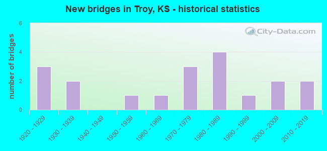
- New bridges - historical statistics
- 31920-1929
- 21930-1939
- 11950-1959
- 11960-1969
- 31970-1979
- 41980-1989
- 11990-1999
- 22000-2009
- 22010-2019


- Bridge Condition - Deck
- 41.2%Very good
- 11.8%Good
- 17.6%Satisfactory
- 11.8%Fair
- 5.9%Poor
- 11.8%Serious

- Bridge Condition - Superstructure
- 29.4%Very good
- 23.5%Good
- 29.4%Satisfactory
- 17.6%Serious

- Bridge Condition - Substructure
- 23.5%Very good
- 17.6%Good
- 23.5%Satisfactory
- 11.8%Fair
- 5.9%Poor
- 17.6%Serious

- Bridge Condition - Channel
- 21.4%Good
- 21.4%Satisfactory
- 42.9%Fair
- 7.1%Poor
- 7.1%Serious
Find on map >> Show street view
Structure Number: 22023, Location: 1.0S 3.5E OF BENDENA (Lat: 39.725000, Lng: -95.119444), Route carried "on" structure: County highway 824, Year Built: 1957, Status: Open, Structure Length: 3.44m (11.29ft), Average Daily Traffic: 108 (year 2005), Truck Traffic: 11%, Average Future Daily Traffic: 150 (year 2041), Design Load: H 15, Features Intersected: ROCK CREEK
Minimum Vertical Clearance: 30.47m (99.97ft), Kilometerpoint: 2.060, Lanes on structure: 2, Owner: County Highway Agency, Approaching Roadway Width: 6.0m (19.7ft), Skew: 3 degrees, Material/Design: Concrete continuous, Design/Construction: Slab, Number Of Spans In Main Unit: 3, Length of Maximum Span: 12.8m (42.0ft), Curb or Sidewalk Widths: Left: 0.5m (1.6ft), Right: 0.5m (1.6ft), Curb-To-Curb Width: 7.3m (24.0ft), Out-to-Out Width: 8.3m (27.2ft)
Condition: Deck: Good, Superstructure: Good, Substructure: Satisfactory, Channel: Good, Operating Rating: 35.3 metric tons, Method Used To Determine Operating Rating: Load Factor (LF), Inventory Rating: 21.1 metric tons, Method Used To Determine Inventory Rating: Load Factor (LF), Structural Evaluation: Equal to present minimum criteria, Deck Geometry: Somewhat better than minimum adequacy, Waterway Adequacy: Equal to present minimum criteria, Approach Roadway Alignment: Better than present minimum criteria, Length Of Structure Improvement: 3.66m (12.01ft), Designated Inspection Frequency: Every 24 months, Inspection Date: Febuary 2021, Bridge Improvement Cost: $210,000, Roadway Improvement Cost: $50,000, Total Project Cost: $315,000, Deck Structure Type: Concrete Cast-file-Place
Find on map >> Show street view
Structure Number: 22036, Location: 4.0N 0.5W OF TROY (Lat: 39.840000, Lng: -95.099444), Route carried "on" structure: County highway 5046, Year Built: 1960, Status: Posted for load, Structure Length: 3.47m (11.38ft), Average Daily Traffic: 175 (year 2005), Truck Traffic: 11%, Average Future Daily Traffic: 200 (year 2041), Design Load: H 15, Features Intersected: MOSQUITO CREEK
Minimum Vertical Clearance: 30.47m (99.97ft), Kilometerpoint: 6.650, Lanes on structure: 2, Owner: County Highway Agency, Approaching Roadway Width: 7.1m (23.3ft), Material/Design: Concrete continuous, Design/Construction: Tee Beam, Number Of Spans In Main Unit: 3, Length of Maximum Span: 13.0m (42.7ft), Curb or Sidewalk Widths: Left: 0.4m (1.3ft), Right: 0.4m (1.3ft), Curb-To-Curb Width: 7.4m (24.3ft), Out-to-Out Width: 8.0m (26.2ft)
Condition: Deck: Fair, Superstructure: Satisfactory, Substructure: Fair, Channel: Serious, Operating Rating: 13.0 metric tons, Method Used To Determine Operating Rating: Load Factor (LF), Inventory Rating: 7.8 metric tons, Method Used To Determine Inventory Rating: Load Factor (LF), Structural Evaluation: High priority of replacement, Deck Geometry: Somewhat better than minimum adequacy, Waterway Adequacy: Equal to present minimum criteria, Approach Roadway Alignment: Equal to present minimum criteria, Bridge Posting: Required (Relationship of Operating Rating to Maximum Legal Load: > 39.9% below), Length Of Structure Improvement: 3.66m (12.01ft), Designated Inspection Frequency: Every 12 months, Inspection Date: Febuary 2021, Bridge Improvement Cost: $210,000, Roadway Improvement Cost: $50,000, Total Project Cost: $315,000, Deck Structure Type: Concrete Cast-file-Place
Find on map >> Show street view
Structure Number: 2204, Location: 1.0S of Troy old K7 (Lat: 39.772717, Lng: -95.097000), Route carried "on" structure: County highway 825, Year Built: 1980, Status: Open, Structure Length: 4.34m (14.24ft), Average Daily Traffic: 870 (year 2007), Truck Traffic: 11%, Average Future Daily Traffic: 900 (year 2041), Design Load: HS 20, Features Intersected: UPRR (Abandon)
Minimum Vertical Clearance: 30.47m (99.97ft), Kilometerpoint: 0.000, Lanes on structure: 2, Owner: County Highway Agency, Approaching Roadway Width: 12.1m (39.7ft), Material/Design: Steel continuous, Design/Construction: Stringer/Multi-beam, Number Of Spans In Main Unit: 3, Length of Maximum Span: 17.1m (56.1ft), Curb or Sidewalk Widths: Left: 0.4m (1.3ft), Right: 0.4m (1.3ft), Curb-To-Curb Width: 11.0m (36.1ft), Out-to-Out Width: 11.7m (38.4ft)
Condition: Deck: Satisfactory, Superstructure: Good, Substructure: Very good, Operating Rating: 63.7 metric tons, Method Used To Determine Operating Rating: Load Factor (LF), Inventory Rating: 38.1 metric tons, Method Used To Determine Inventory Rating: Load Factor (LF), Structural Evaluation: Better than present minimum criteria, Deck Geometry: Better than present minimum criteria, Underclear: Superior to present desirable criteria, Approach Roadway Alignment: Better than present minimum criteria, Designated Inspection Frequency: Every 24 months, Inspection Date: Febuary 2021, Deck Structure Type: Concrete Cast-file-Place, Wearing Surface/Protective System: Wearing Surface: Monolithic Concrete, Deck Protection: Epoxy Coated Reinforcing
Find on map >> Show street view
Structure Number: 221053503243, Location: 2.7N 3.0W OF TROY (Lat: 39.823333, Lng: -95.143333), Route carried "on" structure: County highway , Year Built: 1930, Status: Posted for load, Structure Length: 0.70m (2.30ft), Average Daily Traffic: 35 (year 2005), Average Future Daily Traffic: 35 (year 2041), Features Intersected: COON CREEK, Facility Carried by Structure: LOCAL T-126-1
Minimum Vertical Clearance: 30.47m (99.97ft), Kilometerpoint: 0.000, Lanes on structure: 2, Owner: County Highway Agency, Approaching Roadway Width: 6.0m (19.7ft), Material/Design: Concrete, Design/Construction: Slab, Number Of Spans In Main Unit: 1, Length of Maximum Span: 6.4m (21.0ft), Curb or Sidewalk Widths: Left: 0.4m (1.3ft), Right: 0.4m (1.3ft), Curb-To-Curb Width: 5.9m (19.4ft), Out-to-Out Width: 6.7m (22.0ft)
Condition: Deck: Satisfactory, Superstructure: Satisfactory, Substructure: Satisfactory, Channel: Satisfactory, Operating Rating: 40.0 metric tons, Method Used To Determine Operating Rating: Load Factor (LF), Inventory Rating: 23.9 metric tons, Method Used To Determine Inventory Rating: Load Factor (LF), Structural Evaluation: Equal to present minimum criteria, Deck Geometry: Meets minimum limits, Waterway Adequacy: Equal to present minimum criteria, Approach Roadway Alignment: Equal to present minimum criteria, Bridge Posting: Required (Relationship of Operating Rating to Maximum Legal Load: 20.0 - 29.9% below), Designated Inspection Frequency: Every 24 months, Inspection Date: Febuary 2021, Deck Structure Type: Concrete Cast-file-Place, Wearing Surface/Protective System: Wearing Surface: Gravel
Find on map >> Show street view
Structure Number: 221055603204, Location: 3.5E 0.3S OF SPARKS (Lat: 39.852500, Lng: -95.124389), Route carried "on" structure: County highway , Year Built: 1995, Status: Open, Structure Length: 1.22m (4.00ft), Average Daily Traffic: 55 (year 2005), Average Future Daily Traffic: 55 (year 2041), Design Load: HS 20, Features Intersected: TRIB. TO COON CREEK, Facility Carried by Structure: LOCAL T-26-1
Minimum Vertical Clearance: 30.47m (99.97ft), Kilometerpoint: 0.000, Lanes on structure: 2, Owner: County Highway Agency, Approaching Roadway Width: 5.4m (17.7ft), Material/Design: Steel, Design/Construction: Stringer/Multi-beam, Number Of Spans In Main Unit: 1, Length of Maximum Span: 11.6m (38.1ft), Curb-To-Curb Width: 6.0m (19.7ft), Out-to-Out Width: 6.2m (20.3ft)
Condition: Deck: Very good, Superstructure: Very good, Substructure: Very good, Channel: Fair, Operating Rating: 68.8 metric tons, Method Used To Determine Operating Rating: Load Factor (LF), Inventory Rating: 42.5 metric tons, Method Used To Determine Inventory Rating: Load Factor (LF), Structural Evaluation: Equal to present desirable criteria, Deck Geometry: Meets minimum limits, Waterway Adequacy: Equal to present minimum criteria, Approach Roadway Alignment: Equal to present minimum criteria, Designated Inspection Frequency: Every 24 months, Inspection Date: Febuary 2021, Deck Structure Type: Concrete Cast-file-Place
Find on map >> Show street view
Structure Number: 221057803205, Location: 4.8E 0.4S OF SPARKS (Lat: 39.848917, Lng: -95.100833), Route carried "on" structure: County highway , Year Built: 1988, Status: Open, Structure Length: 3.75m (12.30ft), Average Daily Traffic: 5 (year 2005), Average Future Daily Traffic: 5 (year 2041), Design Load: H 20, Features Intersected: MOSQUITO CREEK, Facility Carried by Structure: LOCAL T-523-1
Minimum Vertical Clearance: 30.47m (99.97ft), Kilometerpoint: 0.000, Lanes on structure: 2, Owner: County Highway Agency, Approaching Roadway Width: 4.8m (15.7ft), Material/Design: Concrete continuous, Design/Construction: Slab, Number Of Spans In Main Unit: 3, Length of Maximum Span: 14.9m (48.9ft), Curb-To-Curb Width: 4.9m (16.1ft), Out-to-Out Width: 5.5m (18.0ft)
Condition: Deck: Very good, Superstructure: Very good, Substructure: Satisfactory, Channel: Fair, Operating Rating: 49.5 metric tons, Method Used To Determine Operating Rating: Load Factor (LF), Inventory Rating: 29.7 metric tons, Method Used To Determine Inventory Rating: Load Factor (LF), Structural Evaluation: Equal to present minimum criteria, Deck Geometry: High priority of corrective action, Waterway Adequacy: Equal to present minimum criteria, Approach Roadway Alignment: Better than present minimum criteria, Designated Inspection Frequency: Every 24 months, Inspection Date: Febuary 2021, Deck Structure Type: Concrete Cast-file-Place
Find on map >> Show street view
Structure Number: 221057803284, Location: W. END OF TROY (Lat: 39.791944, Lng: -95.102500), Route carried "on" structure: County highway , Year Built: 1920, Status: Posted for load, Structure Length: 2.01m (6.59ft), Average Daily Traffic: 5 (year 2005), Average Future Daily Traffic: 5 (year 2041), Features Intersected: MOSQUITO CREEK, Facility Carried by Structure: LOCAL T-731-1
Minimum Vertical Clearance: 30.47m (99.97ft), Kilometerpoint: 0.000, Lanes on structure: 2, Owner: County Highway Agency, Approaching Roadway Width: 3.9m (12.8ft), Material/Design: Concrete, Design/Construction: Tee Beam, Number Of Spans In Main Unit: 3, Length of Maximum Span: 8.5m (27.9ft), Curb or Sidewalk Widths: Left: 0.4m (1.3ft), Right: 0.4m (1.3ft), Curb-To-Curb Width: 6.1m (20.0ft), Out-to-Out Width: 6.9m (22.6ft)
Condition: Deck: Serious, Superstructure: Serious, Substructure: Poor, Channel: Poor, Operating Rating: 20.0 metric tons, Method Used To Determine Operating Rating: No rating analysis performed, Inventory Rating: 14.5 metric tons, Method Used To Determine Inventory Rating: No rating analysis performed, Structural Evaluation: High priority of corrective action, Deck Geometry: Somewhat better than minimum adequacy, Waterway Adequacy: Somewhat better than minimum adequacy, Approach Roadway Alignment: Somewhat better than minimum adequacy, Bridge Posting: Required (Relationship of Operating Rating to Maximum Legal Load: 0.1 - 9.9% below), Length Of Structure Improvement: 2.29m (7.51ft), Designated Inspection Frequency: Every 12 months, Inspection Date: Febuary 2021, Bridge Improvement Cost: $128,000, Roadway Improvement Cost: $15,000, Total Project Cost: $195,000, Deck Structure Type: Concrete Cast-file-Place
Find on map >> Show street view
Structure Number: 221061003247, Location: 0.5E 1.8N OF TROY (Lat: 39.817056, Lng: -95.078139), Route carried "on" structure: County highway 118, Year Built: 2019, Status: Open, Structure Length: 3.12m (10.24ft), Average Daily Traffic: 10 (year 2005), Average Future Daily Traffic: 10 (year 2041), Design Load: HL 93, Features Intersected: TRIB. TO PETERS CREEK, Facility Carried by Structure: LOCAL T-32-1
Minimum Vertical Clearance: 30.47m (99.97ft), Kilometerpoint: 0.000, Lanes on structure: 2, Owner: County Highway Agency, Approaching Roadway Width: 12.1m (39.7ft), Material/Design: Concrete continuous, Design/Construction: Slab, Number Of Spans In Main Unit: 3, Length of Maximum Span: 12.2m (40.0ft), Curb-To-Curb Width: 7.9m (25.9ft), Out-to-Out Width: 8.5m (27.9ft)
Condition: Deck: Very good, Superstructure: Very good, Substructure: Very good, Channel: Satisfactory, Inventory Rating: 59.9 metric tons, Method Used To Determine Inventory Rating: Load and Resistance Factor (LRFR), Structural Evaluation: Equal to present desirable criteria, Deck Geometry: Equal to present minimum criteria, Waterway Adequacy: Better than present minimum criteria, Approach Roadway Alignment: Equal to present desirable criteria, Designated Inspection Frequency: Every 24 months, Inspection Date: Febuary 2021, Deck Structure Type: Concrete Cast-file-Place, Wearing Surface/Protective System: Wearing Surface: Monolithic Concrete
Find on map >> Show street view
Structure Number: 221061003382, Location: 5.8N OF DONIPHAN (Lat: 39.722778, Lng: -95.077778), Route carried "on" structure: County highway , Year Built: 2011, Status: Open, Structure Length: 3.20m (10.50ft), Average Daily Traffic: 30 (year 2005), Average Future Daily Traffic: 30 (year 2041), Design Load: HS 20, Features Intersected: BRUSH CREEK, Facility Carried by Structure: LOCAL T-332-1
Minimum Vertical Clearance: 30.47m (99.97ft), Kilometerpoint: 0.000, Lanes on structure: 2, Owner: County Highway Agency, Approaching Roadway Width: 7.4m (24.3ft), Material/Design: Steel continuous, Design/Construction: Stringer/Multi-beam, Number Of Spans In Main Unit: 3, Length of Maximum Span: 10.7m (35.1ft), Curb-To-Curb Width: 7.3m (24.0ft), Out-to-Out Width: 7.5m (24.6ft)
Condition: Deck: Very good, Superstructure: Good, Substructure: Good, Channel: Good, Operating Rating: 52.4 metric tons, Method Used To Determine Operating Rating: Load Factor (LF), Inventory Rating: 31.4 metric tons, Method Used To Determine Inventory Rating: Load Factor (LF), Structural Evaluation: Better than present minimum criteria, Deck Geometry: Equal to present minimum criteria, Waterway Adequacy: Better than present minimum criteria, Approach Roadway Alignment: Somewhat better than minimum adequacy, Length Of Structure Improvement: 3.20m (10.50ft), Designated Inspection Frequency: Every 24 months, Inspection Date: Febuary 2021, Bridge Improvement Cost: $150,000, Roadway Improvement Cost: $13,000, Total Project Cost: $225,000, Deck Structure Type: Concrete Cast-file-Place
Find on map >> Show street view
Structure Number: 221063303285, Location: 2.0E OF TROY old HWY36 (Lat: 39.791389, Lng: -95.054722), Route carried "on" structure: County highway , Year Built: 1925, Status: Posted for load, Structure Length: 1.13m (3.71ft), Average Daily Traffic: 30 (year 2005), Average Future Daily Traffic: 30 (year 2041), Features Intersected: PETERS CREEK, Facility Carried by Structure: LOCAL T-831-1
Minimum Vertical Clearance: 30.47m (99.97ft), Kilometerpoint: 0.000, Lanes on structure: 2, Owner: County Highway Agency, Approaching Roadway Width: 4.6m (15.1ft), Skew: 3 degrees, Material/Design: Concrete continuous, Design/Construction: Slab, Number Of Spans In Main Unit: 2, Length of Maximum Span: 5.2m (17.1ft), Curb-To-Curb Width: 6.1m (20.0ft), Out-to-Out Width: 6.7m (22.0ft)
Condition: Deck: Serious, Superstructure: Serious, Substructure: Serious, Channel: Fair, Operating Rating: 7.5 metric tons, Method Used To Determine Operating Rating: Load Factor (LF), Inventory Rating: 4.4 metric tons, Method Used To Determine Inventory Rating: Load Factor (LF), Structural Evaluation: High priority of replacement, Deck Geometry: Somewhat better than minimum adequacy, Waterway Adequacy: Somewhat better than minimum adequacy, Approach Roadway Alignment: Somewhat better than minimum adequacy, Bridge Posting: Required (Relationship of Operating Rating to Maximum Legal Load: > 39.9% below), Length Of Structure Improvement: 1.37m (4.49ft), Designated Inspection Frequency: Every 12 months, Inspection Date: Febuary 2021, Bridge Improvement Cost: $77,000, Roadway Improvement Cost: $8,000, Total Project Cost: $115,000, Deck Structure Type: Concrete Cast-file-Place, Wearing Surface/Protective System: Wearing Surface: Monolithic Concrete
Find on map >> Show street view
Structure Number: 221065003224, Location: 3.6N 3.0E OF TROY (Lat: 39.833778, Lng: -95.040000), Route carried "on" structure: County highway , Year Built: 1970, Year Reconstructed: 2013, Status: Posted for load, Structure Length: 0.87m (2.85ft), Average Daily Traffic: 10 (year 2005), Average Future Daily Traffic: 10 (year 2041), Features Intersected: TRIB. TO MISSOURI RIVER, Facility Carried by Structure: LOCAL T-538-2
Minimum Vertical Clearance: 30.47m (99.97ft), Kilometerpoint: 0.000, Lanes on structure: 1, Owner: County Highway Agency, Approaching Roadway Width: 3.2m (10.5ft), Skew: 3 degrees, Material/Design: Steel, Design/Construction: Girder and Floorbeam System, Number Of Spans In Main Unit: 1, Length of Maximum Span: 7.6m (24.9ft), Curb-To-Curb Width: 4.1m (13.5ft), Out-to-Out Width: 4.3m (14.1ft)
Condition: Deck: Very good, Superstructure: Satisfactory, Substructure: Serious, Channel: Fair, Operating Rating: 7.0 metric tons, Method Used To Determine Operating Rating: Load Factor (LF), Inventory Rating: 4.2 metric tons, Method Used To Determine Inventory Rating: Load Factor (LF), Structural Evaluation: High priority of replacement, Deck Geometry: Somewhat better than minimum adequacy, Waterway Adequacy: Equal to present minimum criteria, Approach Roadway Alignment: Meets minimum limits, Bridge Posting: Required (Relationship of Operating Rating to Maximum Legal Load: > 39.9% below), Length Of Structure Improvement: 2.29m (7.51ft), Designated Inspection Frequency: Every 12 months, Inspection Date: Febuary 2021, Bridge Improvement Cost: $130,000, Roadway Improvement Cost: $15,000, Total Project Cost: $195,000, Deck Structure Type: Wood or Timber, Wearing Surface/Protective System: Wearing Surface: Wood or Timber
Find on map >> Show street view
Structure Number: 221065003288, Location: 2.5E OF TROY (Lat: 39.786667, Lng: -95.039611), Route carried "on" structure: County highway , Year Built: 1923, Status: Posted for load, Structure Length: 2.58m (8.46ft), Average Daily Traffic: 100 (year 2019), Average Future Daily Traffic: 30 (year 2041), Features Intersected: C. R.I.& &. RAILROAD, Facility Carried by Structure: LOCAL T-831-2
Minimum Vertical Clearance: 30.47m (99.97ft), Kilometerpoint: 0.000, Lanes on structure: 2, Owner: County Highway Agency, Approaching Roadway Width: 5.1m (16.7ft), Skew: 2 degrees, Material/Design: Concrete, Design/Construction: Stringer/Multi-beam, Number Of Spans In Main Unit: 3, Length of Maximum Span: 8.1m (26.6ft), Curb or Sidewalk Widths: Left: 0.5m (1.6ft), Right: 0.5m (1.6ft), Curb-To-Curb Width: 5.9m (19.4ft), Out-to-Out Width: 7.0m (23.0ft)
Condition: Deck: Poor, Superstructure: Serious, Substructure: Serious, Operating Rating: 5.7 metric tons, Method Used To Determine Operating Rating: Load Factor (LF), Inventory Rating: 3.4 metric tons, Method Used To Determine Inventory Rating: Load Factor (LF), Structural Evaluation: High priority of replacement, Deck Geometry: Meets minimum limits, Underclear: Superior to present desirable criteria, Approach Roadway Alignment: Somewhat better than minimum adequacy, Bridge Posting: Required (Relationship of Operating Rating to Maximum Legal Load: > 39.9% below), Length Of Structure Improvement: 2.90m (9.51ft), Designated Inspection Frequency: Every 12 months, Inspection Date: Febuary 2021, Bridge Improvement Cost: $133,000, Roadway Improvement Cost: $13,000, Total Project Cost: $199,000, Deck Structure Type: Concrete Cast-file-Place
Find on map >> Show street view
Structure Number: 221065003289, Location: 2.0E OF TROY (Lat: 39.783889, Lng: -95.040278), Route carried "on" structure: County highway , Year Built: 1970, Status: Open, Structure Length: 1.14m (3.74ft), Average Daily Traffic: 30 (year 2005), Average Future Daily Traffic: 30 (year 2041), Features Intersected: PETERS CREEK, Facility Carried by Structure: LOCAL T-138-2
Minimum Vertical Clearance: 30.47m (99.97ft), Kilometerpoint: 0.000, Lanes on structure: 2, Owner: County Highway Agency, Approaching Roadway Width: 5.2m (17.1ft), Material/Design: Steel, Design/Construction: Stringer/Multi-beam, Number Of Spans In Main Unit: 1, Length of Maximum Span: 11.1m (36.4ft), Curb-To-Curb Width: 7.1m (23.3ft), Out-to-Out Width: 7.3m (24.0ft)
Condition: Deck: Satisfactory, Superstructure: Satisfactory, Substructure: Satisfactory, Channel: Fair, Operating Rating: 37.8 metric tons, Method Used To Determine Operating Rating: Load Factor (LF), Inventory Rating: 22.7 metric tons, Method Used To Determine Inventory Rating: Load Factor (LF), Structural Evaluation: Equal to present minimum criteria, Deck Geometry: Somewhat better than minimum adequacy, Waterway Adequacy: Somewhat better than minimum adequacy, Approach Roadway Alignment: Somewhat better than minimum adequacy, Designated Inspection Frequency: Every 24 months, Inspection Date: Febuary 2021, Deck Structure Type: Corrugated Steel, Wearing Surface/Protective System: Wearing Surface: Bituminous
Find on map >> Show street view
Structure Number: 221065003301, Location: 2.0E OF TROY (Lat: 39.783417, Lng: -95.040278), Route carried "on" structure: County highway , Year Built: 1970, Status: Open, Structure Length: 1.01m (3.31ft), Average Daily Traffic: 30 (year 2005), Average Future Daily Traffic: 30 (year 2041), Features Intersected: PETERS CREEK, Facility Carried by Structure: LOCAL T-138-1
Minimum Vertical Clearance: 30.47m (99.97ft), Kilometerpoint: 0.000, Lanes on structure: 2, Owner: County Highway Agency, Approaching Roadway Width: 4.4m (14.4ft), Material/Design: Steel, Design/Construction: Stringer/Multi-beam, Number Of Spans In Main Unit: 1, Length of Maximum Span: 9.4m (30.8ft), Curb-To-Curb Width: 6.9m (22.6ft), Out-to-Out Width: 7.0m (23.0ft)
Condition: Deck: Fair, Superstructure: Satisfactory, Substructure: Fair, Channel: Fair, Operating Rating: 34.2 metric tons, Method Used To Determine Operating Rating: Load Factor (LF), Inventory Rating: 20.5 metric tons, Method Used To Determine Inventory Rating: Load Factor (LF), Structural Evaluation: Somewhat better than minimum adequacy, Deck Geometry: Somewhat better than minimum adequacy, Waterway Adequacy: Somewhat better than minimum adequacy, Approach Roadway Alignment: Meets minimum limits, Length Of Structure Improvement: 1.22m (4.00ft), Designated Inspection Frequency: Every 24 months, Inspection Date: Febuary 2021, Bridge Improvement Cost: $70,000, Roadway Improvement Cost: $10,000, Total Project Cost: $105,000, Deck Structure Type: Corrugated Steel, Wearing Surface/Protective System: Wearing Surface: Bituminous
Find on map >> Show street view
Structure Number: 999900700220051, Location: 2.44 M NW US-36/K-7 JCT (Lat: 39.824722, Lng: -95.152222), Route carried "on" structure: State highway 7, Year Built: 1937, Status: Open, Structure Length: 1.36m (4.46ft), Average Daily Traffic: 790 (year 2020), Truck Traffic: 23%, Average Future Daily Traffic: 1,064 (year 2041), Design Load: H 15, Features Intersected: COON CREEK
Minimum Vertical Clearance: 30.47m (99.97ft), Kilometerpoint: 19.414, Lanes on structure: 2, Owner: State Highway Agency, Approaching Roadway Width: 9.8m (32.2ft), Skew: 4 degrees, Material/Design: Concrete, Design/Construction: Culvert, Number Of Spans In Main Unit: 3, Length of Maximum Span: 3.0m (9.8ft), Curb-To-Curb Width: 9.8m (32.2ft), Out-to-Out Width: 10.5m (34.4ft)
Condition: Channel: Satisfactory, Culverts: Satisfactory, Operating Rating: 28.8 metric tons, Method Used To Determine Operating Rating: Load Factor (LF), Inventory Rating: 17.2 metric tons, Method Used To Determine Inventory Rating: Load Factor (LF), Structural Evaluation: Meets minimum limits, Deck Geometry: Equal to present minimum criteria, Waterway Adequacy: High priority of corrective action, Approach Roadway Alignment: Somewhat better than minimum adequacy, Length Of Structure Improvement: 4.47m (14.67ft), Designated Inspection Frequency: Every 24 months, Inspection Date: May 2021, Deck Structure Type: Concrete Cast-file-Place, Wearing Surface/Protective System: Wearing Surface: Bituminous
Find on map >> Show street view
Structure Number: 999900700220501, Location: JCT K7/US36 HWY (Lat: 39.798056, Lng: -95.143056), Route carried "on" structure: State highway 7, Year Built: 2004, Status: Open, Structure Length: 8.50m (27.89ft), Average Daily Traffic: 1,370 (year 2020), Truck Traffic: 16%, Average Future Daily Traffic: 1,845 (year 2041), Design Load: HS 20, Features Intersected: EB & WB US-36 HWY
Minimum Vertical Clearance: 30.47m (99.97ft), Kilometerpoint: 16.225, Lanes on structure: 2, Lanes under structure: 2, Base Highway Network: Yes, Owner: State Highway Agency, Approaching Roadway Width: 12.2m (40.0ft), Material/Design: Prestressed concrete continuous, Design/Construction: Stringer/Multi-beam, Number Of Spans In Main Unit: 4, Length of Maximum Span: 28.0m (91.9ft), Curb-To-Curb Width: 12.2m (40.0ft), Out-to-Out Width: 12.8m (42.0ft)
Condition: Deck: Very good, Superstructure: Very good, Substructure: Good, Operating Rating: 43.7 metric tons, Method Used To Determine Operating Rating: Load and Resistance Factor Rating (LRFR) rating reported by rating factor(RF) method using HL-93 loadings, Inventory Rating: 24.0 metric tons, Method Used To Determine Inventory Rating: Load and Resistance Factor Rating (LRFR) rating reported by rating factor(RF) method using HL-93 loadings, Structural Evaluation: Equal to present minimum criteria, Deck Geometry: Better than present minimum criteria, Underclear: Better than present minimum criteria, Approach Roadway Alignment: Meets minimum limits, Length Of Structure Improvement: 27.89m (91.50ft), Designated Inspection Frequency: Every 24 months, Inspection Date: May 2021, Wearing Surface/Protective System: Wearing Surface: Monolithic Concrete, Deck Protection: Epoxy Coated Reinforcing
Find on map >> Show street view
Structure Number: 999903600220351, Location: 4.08 MI E-EJCT K7 (Lat: 39.783333, Lng: -95.022222), Route carried "on" structure: US 36, Year Built: 1984, Status: Open, Structure Length: 3.73m (12.24ft), Average Daily Traffic: 5,495 (year 2020), Truck Traffic: 19%, Average Future Daily Traffic: 7,851 (year 2041), Design Load: HS 20, Features Intersected: PETERS CREEK DRAINAGE
Minimum Vertical Clearance: 30.47m (99.97ft), Kilometerpoint: 28.819, Lanes on structure: 2, Base Highway Network: Yes, Owner: State Highway Agency, Approaching Roadway Width: 12.2m (40.0ft), Material/Design: Concrete continuous, Design/Construction: Slab, Number Of Spans In Main Unit: 3, Length of Maximum Span: 14.6m (47.9ft), Curb-To-Curb Width: 12.2m (40.0ft), Out-to-Out Width: 12.8m (42.0ft)
Condition: Deck: Good, Superstructure: Good, Substructure: Good, Channel: Good, Operating Rating: 77.1 metric tons, Method Used To Determine Operating Rating: Load Factor (LF), Inventory Rating: 46.3 metric tons, Method Used To Determine Inventory Rating: Load Factor (LF), Structural Evaluation: Better than present minimum criteria, Deck Geometry: Somewhat better than minimum adequacy, Waterway Adequacy: Equal to present minimum criteria, Approach Roadway Alignment: Equal to present desirable criteria, Length Of Structure Improvement: 12.25m (40.19ft), Designated Inspection Frequency: Every 24 months, Inspection Date: May 2021, Deck Structure Type: Concrete Cast-file-Place, Wearing Surface/Protective System: Wearing Surface: Monolithic Concrete, Deck Protection: Epoxy Coated Reinforcing
Find on map >> Show street view
Structure Number: 999903600220431, Location: U36/K136 (Lat: 39.794444, Lng: -95.096667), Route carried "on" structure: US 36, Year Built: 1989, Status: Open, Structure Length: 5.33m (17.49ft), Average Daily Traffic: 5,495 (year 2020), Truck Traffic: 19%, Average Future Daily Traffic: 8,492 (year 2041), Design Load: HS 20, Features Intersected: K136 HWY
Minimum Vertical Clearance: 30.47m (99.97ft), Kilometerpoint: 22.174, Lanes on structure: 2, Lanes under structure: 2, Base Highway Network: Yes, Owner: State Highway Agency, Approaching Roadway Width: 13.4m (44.0ft), Material/Design: Prestressed concrete continuous, Design/Construction: Stringer/Multi-beam, Number Of Spans In Main Unit: 3, Length of Maximum Span: 27.4m (89.9ft), Curb-To-Curb Width: 13.4m (44.0ft), Out-to-Out Width: 14.2m (46.6ft)
Condition: Deck: Very good, Superstructure: Very good, Substructure: Very good, Operating Rating: 62.6 metric tons, Method Used To Determine Operating Rating: Load Factor (LF), Inventory Rating: 20.9 metric tons, Method Used To Determine Inventory Rating: Load Factor (LF), Structural Evaluation: Somewhat better than minimum adequacy, Deck Geometry: Equal to present minimum criteria, Underclear: Superior to present desirable criteria, Approach Roadway Alignment: Meets minimum limits, Length Of Structure Improvement: 17.50m (57.41ft), Designated Inspection Frequency: Every 24 months, Inspection Date: May 2021, Wearing Surface/Protective System: Wearing Surface: Monolithic Concrete, Deck Protection: Epoxy Coated Reinforcing
Find on map >> Show street view
Structure Number: 999900700220501, Location: JCT K7/US36 HWY (Lat: 39.798056, Lng: -95.143056), Route carried "under" structure: US 36, Year Built: 2004, Structure Length: 0. m, Average Daily Traffic: 4,156 (year 2020), Truck Traffic: 23%, Features Intersected: EB & WB US-36 HWY, Facility Carried by Structure: K-7 HWY
Minimum Vertical Clearance: 5.01m (16.44ft), Kilometerpoint: 18.163, Lanes on structure: 2, Lanes under structure: 2, Material/Design: Prestressed concrete continuous, Design/Construction: Stringer/Multi-beam, Length of Maximum Span: 28.0m (91.9ft)