Bridge Statistics for Tuckerton, New Jersey (NJ)
Condition, Traffic, Stress, Structural Evaluation, Project Costs
- National Bridge Inventory (NBI) Statistics
- 16Number of bridges
- 66ft / 19.9mTotal length
- 284,737Total average daily traffic
- 8,687Total average daily truck traffic
- National Bridge Inventory (NBI) Registered Bridges for Tuckerton
- No street view available for this location
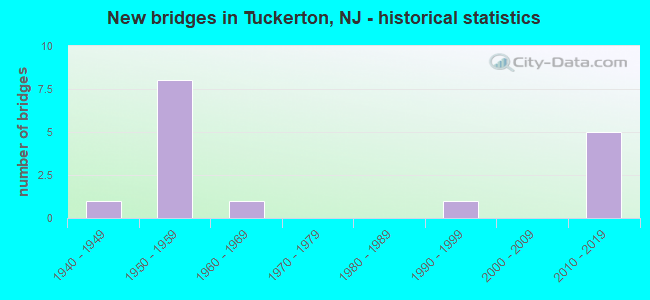
- New bridges - historical statistics
- 11940-1949
- 81950-1959
- 11960-1969
- 11990-1999
- 52010-2019

- Reconstructed bridges - Historical Statistics
- 11980-1989
- 01990-1999
- 32000-2009


- Bridge Condition - Deck
- 28.6%Very good
- 57.1%Good
- 14.3%Fair

- Bridge Condition - Superstructure
- 71.4%Very good
- 14.3%Good
- 14.3%Fair

- Bridge Condition - Substructure
- 85.7%Good
- 14.3%Satisfactory

- Bridge Condition - Channel
- 25.0%Very good
- 12.5%Good
- 50.0%Satisfactory
- 12.5%Fair

- Bridge Condition - Culverts
- 20.0%Very good
- 20.0%Good
- 60.0%Satisfactory
Find on map >> Show street view
Structure Number: 150116, Location: 0.2 MI SOUTH OF GREEN ST (Lat: 39.602139, Lng: -74.342689), Route carried "on" structure: US 9, Year Built: 2013, Status: Open, Structure Length: 1.04m (3.41ft), Average Daily Traffic: 15,820 (year 2019), Truck Traffic: 4%, Average Future Daily Traffic: 19,304 (year 2039), Design Load: HL 93, Features Intersected: Tuckerton Creek
Minimum Vertical Clearance: 30+ m (98+ ft), Kilometerpoint: 100.713, Lanes on structure: 2, Owner: State Highway Agency, Approaching Roadway Width: 13.3m (43.6ft), Material/Design: Concrete, Design/Construction: Culvert, Number Of Spans In Main Unit: 2, Length of Maximum Span: 4.9m (16.1ft), Curb or Sidewalk Widths: Left: 1.2m (3.9ft), Right: 1.9m (6.2ft)
Condition: Channel: Very good, Culverts: Very good, Operating Rating: 70.3 metric tons, Method Used To Determine Operating Rating: Load and Resistance Factor Rating (LRFR) rating reported by rating factor(RF) method using HL-93 loadings, Inventory Rating: 54.1 metric tons, Method Used To Determine Inventory Rating: Load and Resistance Factor Rating (LRFR) rating reported by rating factor(RF) method using HL-93 loadings, Structural Evaluation: Equal to present desirable criteria, Waterway Adequacy: Superior to present desirable criteria, Approach Roadway Alignment: Equal to present desirable criteria, Designated Inspection Frequency: Every 24 months, Inspection Date: January 2020
Find on map >> Show street view
Structure Number: 1508002, Location: 4 MI. EAST EXIT 58 GSP (Lat: 39.622719, Lng: -74.280750), Route carried "on" structure: County highway 602, Year Built: 1993, Status: Open, Structure Length: 1.31m (4.30ft), Average Daily Traffic: 609 (year 2020), Truck Traffic: 3%, Average Future Daily Traffic: 731 (year 2040), Design Load: HS 25 or greater, Features Intersected: SOUTH CREEK
Minimum Vertical Clearance: 30+ m (98+ ft), Kilometerpoint: 6.470, Lanes on structure: 2, Owner: County Highway Agency, Approaching Roadway Width: 8.2m (26.9ft), Material/Design: Prestressed concrete, Design/Construction: Slab, Number Of Spans In Main Unit: 1, Length of Maximum Span: 12.2m (40.0ft), Curb-To-Curb Width: 9.0m (29.5ft), Out-to-Out Width: 10.1m (33.1ft)
Condition: Deck: Very good, Superstructure: Very good, Substructure: Good, Channel: Very good, Operating Rating: 51.7 metric tons, Method Used To Determine Operating Rating: Load Factor (LF), Inventory Rating: 30.8 metric tons, Method Used To Determine Inventory Rating: Load Factor (LF), Structural Evaluation: Better than present minimum criteria, Deck Geometry: Somewhat better than minimum adequacy, Waterway Adequacy: Equal to present desirable criteria, Approach Roadway Alignment: Equal to present desirable criteria, Designated Inspection Frequency: Every 24 months, Inspection Date: April 2020, Deck Structure Type: Concrete Precast Panels, Wearing Surface/Protective System: Wearing Surface: Bituminous, Membrane: Other, Deck Protection: Other
Find on map >> Show street view
Structure Number: 1508004, Location: 1.5MI east of Rt 539 (Lat: 39.666581, Lng: -74.320281), Route carried "on" structure: County highway 606, Year Built: 1942, Year Reconstructed: 1986, Status: Open, Structure Length: 1.13m (3.71ft), Average Daily Traffic: 879 (year 2020), Truck Traffic: 5%, Average Future Daily Traffic: 1,055 (year 2040), Design Load: HS 20, Features Intersected: WESTECUNK CREEK, Facility Carried by Structure: STAFFORD FORGE RD
Minimum Vertical Clearance: 30+ m (98+ ft), Kilometerpoint: 2.414, Lanes on structure: 2, Owner: County Highway Agency, Approaching Roadway Width: 9.1m (29.9ft), Material/Design: Wood or Timber, Design/Construction: Slab, Number Of Spans In Main Unit: 1, Length of Maximum Span: 11.0m (36.1ft), Curb-To-Curb Width: 9.1m (29.9ft), Out-to-Out Width: 9.6m (31.5ft)
Condition: Deck: Good, Superstructure: Good, Substructure: Good, Channel: Good, Operating Rating: 53.5 metric tons, Method Used To Determine Operating Rating: Allowable Stress (AS), Inventory Rating: 36.3 metric tons, Method Used To Determine Inventory Rating: Allowable Stress (AS), Structural Evaluation: Better than present minimum criteria, Deck Geometry: Equal to present minimum criteria, Waterway Adequacy: Equal to present desirable criteria, Approach Roadway Alignment: Equal to present desirable criteria, Designated Inspection Frequency: Every 24 months, Inspection Date: April 2020, Deck Structure Type: Wood or Timber, Wearing Surface/Protective System: Wearing Surface: Bituminous
Find on map >> Show street view
Structure Number: 1508005, Location: .4 MI. N. OF CR 602 (Lat: 39.640211, Lng: -74.307961), Route carried "on" structure: County highway 35, Year Built: 1967, Status: Open, Structure Length: 1.37m (4.49ft), Average Daily Traffic: 1,171 (year 2020), Truck Traffic: 1%, Average Future Daily Traffic: 1,405 (year 2040), Design Load: HS 20, Features Intersected: WESTECUNK CREEK, Facility Carried by Structure: RAILROAD AVENUE
Minimum Vertical Clearance: 30+ m (98+ ft), Kilometerpoint: 4.989, Lanes on structure: 2, Owner: County Highway Agency, Approaching Roadway Width: 9.1m (29.9ft), Material/Design: Concrete, Design/Construction: Slab, Number Of Spans In Main Unit: 2, Length of Maximum Span: 6.4m (21.0ft), Curb-To-Curb Width: 9.1m (29.9ft), Out-to-Out Width: 9.9m (32.5ft)
Condition: Deck: Fair, Superstructure: Fair, Substructure: Satisfactory, Channel: Satisfactory, Operating Rating: 29.9 metric tons, Method Used To Determine Operating Rating: Load Factor (LF), Inventory Rating: 18.1 metric tons, Method Used To Determine Inventory Rating: Load Factor (LF), Structural Evaluation: Somewhat better than minimum adequacy, Deck Geometry: Somewhat better than minimum adequacy, Waterway Adequacy: Equal to present desirable criteria, Approach Roadway Alignment: Equal to present desirable criteria, Designated Inspection Frequency: Every 24 months, Underwater Inspection Frequency: Every 48 months, Inspection Date: May 2020, Underwater Inspection Date: May 2020, Deck Structure Type: Concrete Precast Panels, Wearing Surface/Protective System: Wearing Surface: Bituminous
Find on map >> Show street view
Structure Number: 360574N, Location: 1.3 MI S OF CO539&GSP JCT (Lat: 39.642328, Lng: -74.363300), Route carried "on" structure: Other road GSP, Year Built: 1954, Year Reconstructed: 2013, Status: Open, Structure Length: 0.67m (2.20ft), Average Daily Traffic: 27,544 (year 2021), Truck Traffic: 3%, Average Future Daily Traffic: 33,609 (year 2041), Design Load: HS 20, Features Intersected: SHORDS MILL BRANCH
Minimum Vertical Clearance: 30+ m (98+ ft), Kilometerpoint: 92.376, Lanes on structure: 3, Base Highway Network: Yes, Toll: On toll road, Owner: State Toll Authority, Approaching Roadway Width: 17.7m (58.1ft), Skew: 2 degrees, Material/Design: Concrete, Design/Construction: Culvert, Number Of Spans In Main Unit: 1, Length of Maximum Span: 6.1m (20.0ft)
Condition: Channel: Satisfactory, Culverts: Satisfactory, Operating Rating: 96.9 metric tons, Method Used To Determine Operating Rating: Load and Resistance Factor Rating (LRFR) rating reported by rating factor(RF) method using HL-93 loadings, Inventory Rating: 96.9 metric tons, Method Used To Determine Inventory Rating: Load and Resistance Factor Rating (LRFR) rating reported by rating factor(RF) method using HL-93 loadings, Structural Evaluation: Equal to present minimum criteria, Waterway Adequacy: Better than present minimum criteria, Approach Roadway Alignment: Equal to present desirable criteria, Designated Inspection Frequency: Every 24 months, Inspection Date: March 2021
Find on map >> Show street view
Structure Number: 360574S, Location: 1.3 MI S OF CR539&GSP JCT (Lat: 39.642739, Lng: -74.365444), Route carried "on" structure: Other road GSP, Year Built: 1954, Status: Open, Structure Length: 0.79m (2.59ft), Average Daily Traffic: 37,753 (year 2021), Truck Traffic: 3%, Average Future Daily Traffic: 46,066 (year 2041), Features Intersected: SHORDS MILL BRANCH
Minimum Vertical Clearance: 30+ m (98+ ft), Kilometerpoint: 92.376, Lanes on structure: 3, Base Highway Network: Yes, Toll: On toll road, Owner: State Toll Authority, Approaching Roadway Width: 17.7m (58.1ft), Skew: 4 degrees, Material/Design: Concrete, Design/Construction: Culvert, Number Of Spans In Main Unit: 1, Length of Maximum Span: 6.1m (20.0ft)
Condition: Channel: Fair, Culverts: Good, Operating Rating: 96.9 metric tons, Method Used To Determine Operating Rating: Load and Resistance Factor Rating (LRFR) rating reported by rating factor(RF) method using HL-93 loadings, Inventory Rating: 76.1 metric tons, Method Used To Determine Inventory Rating: Load and Resistance Factor Rating (LRFR) rating reported by rating factor(RF) method using HL-93 loadings, Structural Evaluation: Better than present minimum criteria, Waterway Adequacy: Equal to present desirable criteria, Approach Roadway Alignment: Equal to present desirable criteria, Designated Inspection Frequency: Every 24 months, Inspection Date: March 2021
Find on map >> Show street view
Structure Number: 360587N, Location: 3.5 MI N of US9&539 JCT (Lat: 39.654328, Lng: -74.344617), Route carried "on" structure: County highway 539, Year Built: 2013, Status: Open, Structure Length: 2.62m (8.60ft), Average Daily Traffic: 17,110 (year 2021), Truck Traffic: 3%, Average Future Daily Traffic: 20,877 (year 2041), Design Load: HL 93, Features Intersected: GSP NB
Minimum Vertical Clearance: 30+ m (98+ ft), Kilometerpoint: 5.617, Lanes on structure: 2, Lanes under structure: 3, Owner: State Toll Authority, Approaching Roadway Width: 14.6m (47.9ft), Skew: 1 degrees, Material/Design: Steel, Design/Construction: Stringer/Multi-beam, Number Of Spans In Main Unit: 1, Length of Maximum Span: 25.3m (83.0ft), Curb-To-Curb Width: 14.6m (47.9ft), Out-to-Out Width: 15.7m (51.5ft)
Condition: Deck: Good, Superstructure: Very good, Substructure: Good, Operating Rating: 62.5 metric tons, Method Used To Determine Operating Rating: Load and Resistance Factor Rating (LRFR) rating reported by rating factor(RF) method using HL-93 loadings, Inventory Rating: 48.3 metric tons, Method Used To Determine Inventory Rating: Load and Resistance Factor Rating (LRFR) rating reported by rating factor(RF) method using HL-93 loadings, Structural Evaluation: Better than present minimum criteria, Deck Geometry: Superior to present desirable criteria, Underclear: Meets minimum limits, Approach Roadway Alignment: Equal to present desirable criteria, Designated Inspection Frequency: Every 24 months, Inspection Date: March 2021, Deck Structure Type: Concrete Cast-file-Place, Wearing Surface/Protective System: Wearing Surface: Monolithic Concrete, Deck Protection: Epoxy Coated Reinforcing
Find on map >> Show street view
Structure Number: 360588S, Location: 3.5 MI N OF US9&539 JCT (Lat: 39.653139, Lng: -74.344139), Route carried "on" structure: County highway 539, Year Built: 2013, Status: Open, Structure Length: 2.62m (8.60ft), Average Daily Traffic: 17,110 (year 2021), Truck Traffic: 3%, Average Future Daily Traffic: 20,877 (year 2041), Design Load: HL 93, Features Intersected: GSP SB
Minimum Vertical Clearance: 30+ m (98+ ft), Kilometerpoint: 5.745, Lanes on structure: 2, Lanes under structure: 3, Owner: State Toll Authority, Approaching Roadway Width: 14.6m (47.9ft), Skew: 1 degrees, Material/Design: Steel, Design/Construction: Stringer/Multi-beam, Number Of Spans In Main Unit: 1, Length of Maximum Span: 25.3m (83.0ft), Curb-To-Curb Width: 14.6m (47.9ft), Out-to-Out Width: 15.7m (51.5ft)
Condition: Deck: Good, Superstructure: Very good, Substructure: Good, Operating Rating: 61.6 metric tons, Method Used To Determine Operating Rating: Load and Resistance Factor Rating (LRFR) rating reported by rating factor(RF) method using HL-93 loadings, Inventory Rating: 47.3 metric tons, Method Used To Determine Inventory Rating: Load and Resistance Factor Rating (LRFR) rating reported by rating factor(RF) method using HL-93 loadings, Structural Evaluation: Better than present minimum criteria, Deck Geometry: Superior to present desirable criteria, Underclear: Somewhat better than minimum adequacy, Approach Roadway Alignment: Equal to present desirable criteria, Designated Inspection Frequency: Every 24 months, Inspection Date: March 2021, Deck Structure Type: Concrete Cast-file-Place, Wearing Surface/Protective System: Wearing Surface: Monolithic Concrete, Deck Protection: Epoxy Coated Reinforcing
Find on map >> Show street view
Structure Number: 360602N, Location: 0.2 miles S. of CR 606 (Lat: 39.664542, Lng: -74.318842), Route carried "on" structure: Other road GSP, Year Built: 1954, Status: Open, Structure Length: 0.98m (3.22ft), Average Daily Traffic: 24,508 (year 2021), Truck Traffic: 3%, Average Future Daily Traffic: 29,905 (year 2041), Features Intersected: WESTECUNK CREEK
Minimum Vertical Clearance: 30+ m (98+ ft), Kilometerpoint: 96.947, Lanes on structure: 3, Base Highway Network: Yes, Toll: On toll road, Owner: State Toll Authority, Approaching Roadway Width: 17.7m (58.1ft), Material/Design: Concrete, Design/Construction: Culvert, Number Of Spans In Main Unit: 2, Length of Maximum Span: 4.6m (15.1ft)
Condition: Channel: Satisfactory, Culverts: Satisfactory, Structural Evaluation: Equal to present minimum criteria, Waterway Adequacy: Better than present minimum criteria, Approach Roadway Alignment: Equal to present desirable criteria, Designated Inspection Frequency: Every 24 months, Inspection Date: April 2021
Find on map >> Show street view
Structure Number: 360602S, Location: 0.2 miles S. of CR 606 (Lat: 39.665819, Lng: -74.319561), Route carried "on" structure: Other road GSP, Year Built: 1954, Status: Open, Structure Length: 0.98m (3.22ft), Average Daily Traffic: 24,508 (year 2021), Truck Traffic: 3%, Average Future Daily Traffic: 24,905 (year 2041), Features Intersected: WESTECUNK CREEK
Minimum Vertical Clearance: 30+ m (98+ ft), Kilometerpoint: 96.947, Lanes on structure: 3, Base Highway Network: Yes, Toll: On toll road, Owner: State Toll Authority, Approaching Roadway Width: 17.7m (58.1ft), Material/Design: Concrete, Design/Construction: Culvert, Number Of Spans In Main Unit: 2, Length of Maximum Span: 4.6m (15.1ft)
Condition: Channel: Satisfactory, Culverts: Satisfactory, Structural Evaluation: Equal to present minimum criteria, Waterway Adequacy: Better than present minimum criteria, Approach Roadway Alignment: Equal to present desirable criteria, Designated Inspection Frequency: Every 24 months, Inspection Date: April 2021
Find on map >> Show street view
Structure Number: 360603N, Location: 3.8 MI SW OF NJ72&GSP JCT (Lat: 39.665792, Lng: -74.317306), Route carried "on" structure: Other road GSP, Year Built: 1954, Year Reconstructed: 2013, Status: Open, Structure Length: 3.20m (10.50ft), Average Daily Traffic: 24,992 (year 2021), Truck Traffic: 3%, Average Future Daily Traffic: 30,495 (year 2041), Design Load: HL 93, Features Intersected: STAFFORD FORGE RD(CR606)
Minimum Vertical Clearance: 30+ m (98+ ft), Kilometerpoint: 97.140, Lanes on structure: 3, Lanes under structure: 2, Base Highway Network: Yes, Toll: On toll road, Owner: State Toll Authority, Approaching Roadway Width: 18.3m (60.0ft), Skew: 1 degrees, Material/Design: Steel continuous, Design/Construction: Stringer/Multi-beam, Number Of Spans In Main Unit: 3, Length of Maximum Span: 13.7m (44.9ft), Curb-To-Curb Width: 18.7m (61.4ft), Out-to-Out Width: 19.9m (65.3ft)
Condition: Deck: Good, Superstructure: Very good, Substructure: Good, Operating Rating: 96.9 metric tons, Method Used To Determine Operating Rating: Load and Resistance Factor Rating (LRFR) rating reported by rating factor(RF) method using HL-93 loadings, Inventory Rating: 75.8 metric tons, Method Used To Determine Inventory Rating: Load and Resistance Factor Rating (LRFR) rating reported by rating factor(RF) method using HL-93 loadings, Structural Evaluation: Better than present minimum criteria, Deck Geometry: Superior to present desirable criteria, Underclear: Meets minimum limits, Approach Roadway Alignment: Equal to present desirable criteria, Designated Inspection Frequency: Every 24 months, Inspection Date: March 2021, Deck Structure Type: Concrete Cast-file-Place, Wearing Surface/Protective System: Wearing Surface: Monolithic Concrete, Deck Protection: Epoxy Coated Reinforcing
Find on map >> Show street view
Structure Number: 360604S, Location: 3.8 MI SW OF RT72&GSP JCT (Lat: 39.666517, Lng: -74.318786), Route carried "on" structure: Other road GSP, Year Built: 1954, Year Reconstructed: 2013, Status: Open, Structure Length: 3.14m (10.30ft), Average Daily Traffic: 27,033 (year 2021), Truck Traffic: 3%, Average Future Daily Traffic: 32,985 (year 2041), Design Load: HL 93, Features Intersected: STAFFORD FORGE RD(CR606)
Minimum Vertical Clearance: 30+ m (98+ ft), Kilometerpoint: 97.140, Lanes on structure: 3, Lanes under structure: 2, Base Highway Network: Yes, Toll: On toll road, Owner: State Toll Authority, Approaching Roadway Width: 18.3m (60.0ft), Skew: 1 degrees, Material/Design: Steel continuous, Design/Construction: Stringer/Multi-beam, Number Of Spans In Main Unit: 3, Length of Maximum Span: 13.4m (44.0ft), Curb-To-Curb Width: 18.3m (60.0ft), Out-to-Out Width: 19.4m (63.6ft)
Condition: Deck: Very good, Superstructure: Very good, Substructure: Good, Operating Rating: 96.9 metric tons, Method Used To Determine Operating Rating: Load and Resistance Factor Rating (LRFR) rating reported by rating factor(RF) method using HL-93 loadings, Inventory Rating: 81.3 metric tons, Method Used To Determine Inventory Rating: Load and Resistance Factor Rating (LRFR) rating reported by rating factor(RF) method using HL-93 loadings, Structural Evaluation: Better than present minimum criteria, Deck Geometry: Better than present minimum criteria, Underclear: Meets minimum limits, Approach Roadway Alignment: Equal to present desirable criteria, Designated Inspection Frequency: Every 24 months, Inspection Date: March 2021, Deck Structure Type: Concrete Cast-file-Place, Wearing Surface/Protective System: Wearing Surface: Monolithic Concrete, Deck Protection: Epoxy Coated Reinforcing
Find on map >> Show street view
Structure Number: 360587N, Location: 3.5 MI N of US9&539 JCT (Lat: 39.654328, Lng: -74.344617), Route carried "under" structure: Other road GSP, Year Built: 2013, Structure Length: 0. m, Average Daily Traffic: 31,980 (year 2021), Truck Traffic: 3%, Features Intersected: GSP NB, Facility Carried by Structure: GREEN ST (CR 539)
Minimum Vertical Clearance: 5.00m (16.40ft), Kilometerpoint: 94.452, Lanes on structure: 2, Lanes under structure: 3, Toll: On toll road, Material/Design: Steel, Design/Construction: Stringer/Multi-beam, Length of Maximum Span: 25.3m (83.0ft)
Find on map >> Show street view
Structure Number: 360588S, Location: 3.5 MI N OF US9&539 JCT (Lat: 39.653139, Lng: -74.344139), Route carried "under" structure: Other road GSP, Year Built: 2013, Structure Length: 0. m, Average Daily Traffic: 31,980 (year 2021), Truck Traffic: 3%, Features Intersected: GSP SB, Facility Carried by Structure: GREEN ST (CR 539)
Minimum Vertical Clearance: 5.39m (17.68ft), Kilometerpoint: 94.452, Lanes on structure: 2, Lanes under structure: 3, Toll: On toll road, Material/Design: Steel, Design/Construction: Stringer/Multi-beam, Length of Maximum Span: 25.3m (83.0ft)
Find on map >> Show street view
Structure Number: 360603N, Location: 3.8 MI SW OF NJ72&GSP JCT (Lat: 39.665792, Lng: -74.317306), Route carried "under" structure: County highway 606, Year Built: 1954, Structure Length: 0. m, Average Daily Traffic: 870 (year 2021), Truck Traffic: 3%, Features Intersected: STAFFORD FORGE RD(CR606), Facility Carried by Structure: GSP NB
Minimum Vertical Clearance: 4.42m (14.50ft), Kilometerpoint: 2.768, Lanes on structure: 3, Lanes under structure: 2, Material/Design: Steel continuous, Design/Construction: Stringer/Multi-beam, Length of Maximum Span: 13.7m (44.9ft)
Find on map >> Show street view
Structure Number: 360604S, Location: 3.8 MI SW OF RT72&GSP JCT (Lat: 39.666517, Lng: -74.318786), Route carried "under" structure: County highway 606, Year Built: 1954, Structure Length: 0. m, Average Daily Traffic: 870 (year 2021), Truck Traffic: 3%, Features Intersected: STAFFORD FORGE RD(CR606), Facility Carried by Structure: GSP SB
Minimum Vertical Clearance: 4.42m (14.50ft), Kilometerpoint: 2.623, Lanes on structure: 3, Lanes under structure: 2, Material/Design: Steel continuous, Design/Construction: Stringer/Multi-beam, Length of Maximum Span: 13.4m (44.0ft)