Bridge Statistics for Tunica, Mississippi (MS)
Condition, Traffic, Stress, Structural Evaluation, Project Costs
- National Bridge Inventory (NBI) Statistics
- 10Number of bridges
- 56ft / 16.6mTotal length
- $2,268,000Total costs
- 5,515Total average daily traffic
- 582Total average daily truck traffic
- 8,235Total future (year 2031) average daily traffic
- National Bridge Inventory (NBI) Registered Bridges for Tunica
- No street view available for this location
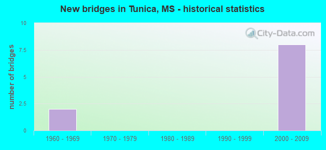
- New bridges - historical statistics
- 21960-1969
- 82000-2009


- Bridge Condition - Deck
- 50.0%Satisfactory
- 50.0%Fair

- Bridge Condition - Substructure
- 50.0%Poor
- 50.0%Critical

- Bridge Condition - Channel
- 10.0%Very good
- 50.0%Good
- 10.0%Satisfactory
- 30.0%Fair
Find on map >> Show street view
Structure Number: SA7200000000002, Location: SEC 22 T 3S R10W B (Lat: 34.802914, Lng: -90.250672), Route carried "on" structure: County highway 39, Year Built: 1967, Status: Closed, Structure Length: 4.05m (13.29ft), Average Daily Traffic: 150 (year 2011), Truck Traffic: 25%, Average Future Daily Traffic: 225 (year 2031), Design Load: H 15, Features Intersected: LOST LAKE BAYOU, Facility Carried by Structure: COUNCE ROAD WEST
Minimum Vertical Clearance: 30+ m (98+ ft), Kilometerpoint: 2.092, Lanes on structure: 2, Owner: County Highway Agency, Approaching Roadway Width: 8.2m (26.9ft), Material/Design: Concrete, Design/Construction: Channel Beam, Number Of Spans In Main Unit: 7, Length of Maximum Span: 5.8m (19.0ft), Curb or Sidewalk Widths: Left: 0.3m (1.0ft), Right: 0.3m (1.0ft), Curb-To-Curb Width: 8.2m (26.9ft), Out-to-Out Width: 8.8m (28.9ft)
Condition: Deck: Fair, Superstructure: Poor, Substructure: Critical, Channel: Good, Deck Geometry: Somewhat better than minimum adequacy, Waterway Adequacy: Superior to present desirable criteria, Approach Roadway Alignment: Better than present minimum criteria, Bridge Posting: Required (Relationship of Operating Rating to Maximum Legal Load: > 39.9% below), Length Of Structure Improvement: 5.79m (19.00ft), Designated Inspection Frequency: Every 24 months, Inspection Date: December 2020, Bridge Improvement Cost: $850,000, Roadway Improvement Cost: $100,000, Total Project Cost: $950,000 ( Estimate for 2021), Deck Structure Type: Concrete Precast Panels, Wearing Surface/Protective System: Wearing Surface: Bituminous
Find on map >> Show street view
Structure Number: SA7200000000018, Location: SEC 32 T 4S R11W (Lat: 34.682019, Lng: -90.385514), Route carried "on" structure: County highway 78, Year Built: 2005, Status: Open, Structure Length: 0.80m (2.62ft), Average Daily Traffic: 425 (year 2019), Truck Traffic: 8%, Average Future Daily Traffic: 600 (year 2039), Design Load: HS 20, Features Intersected: SUGAR DITCH, Facility Carried by Structure: TIL ROAD NORTH
Minimum Vertical Clearance: 30+ m (98+ ft), Kilometerpoint: 1.609, Lanes on structure: 2, Owner: County Highway Agency, Approaching Roadway Width: 11.0m (36.1ft), Material/Design: Concrete, Design/Construction: Culvert, Number Of Spans In Main Unit: 2, Length of Maximum Span: 3.7m (12.1ft)
Condition: Channel: Fair, Culverts: Very good, Operating Rating: 57.2 metric tons, Method Used To Determine Operating Rating: Load Factor (LF), Inventory Rating: 34.3 metric tons, Method Used To Determine Inventory Rating: Load Factor (LF), Structural Evaluation: Equal to present desirable criteria, Waterway Adequacy: Better than present minimum criteria, Approach Roadway Alignment: Better than present minimum criteria, Designated Inspection Frequency: Every 24 months, Inspection Date: December 2020
Find on map >> Show street view
Structure Number: SA720000000002, Location: SEC 35 T 4S R12W B (Lat: 34.699083, Lng: -90.441778), Route carried "on" structure: County highway 66, Year Built: 1968, Status: Posted for load, Structure Length: 5.27m (17.29ft), Average Daily Traffic: 690 (year 2020), Truck Traffic: 8%, Average Future Daily Traffic: 1,035 (year 2042), Design Load: H 15, Features Intersected: MCKINNEY LAKE, Facility Carried by Structure: CUTOFF ROAD
Minimum Vertical Clearance: 30+ m (98+ ft), Kilometerpoint: 2.414, Lanes on structure: 2, Owner: County Highway Agency, Approaching Roadway Width: 7.5m (24.6ft), Material/Design: Concrete, Design/Construction: Channel Beam, Number Of Spans In Main Unit: 9, Length of Maximum Span: 5.8m (19.0ft), Curb or Sidewalk Widths: Left: 0.2m (0.7ft), Right: 0.2m (0.7ft), Curb-To-Curb Width: 8.1m (26.6ft), Out-to-Out Width: 8.6m (28.2ft)
Condition: Deck: Satisfactory, Superstructure: Poor, Substructure: Poor, Channel: Good, Operating Rating: 9.7 metric tons, Method Used To Determine Operating Rating: Load Factor (LF), Inventory Rating: 1.7 metric tons, Method Used To Determine Inventory Rating: Load Factor (LF), Structural Evaluation: High priority of replacement, Deck Geometry: Somewhat better than minimum adequacy, Waterway Adequacy: Superior to present desirable criteria, Approach Roadway Alignment: Equal to present desirable criteria, Bridge Posting: Required (Relationship of Operating Rating to Maximum Legal Load: > 39.9% below), Length Of Structure Improvement: 7.91m (25.95ft), Designated Inspection Frequency: Every 12 months, Inspection Date: December 2021, Bridge Improvement Cost: $732,000, Roadway Improvement Cost: $586,000, Total Project Cost: $1,318,000 ( Estimate for 2020), Deck Structure Type: Concrete Precast Panels, Wearing Surface/Protective System: Wearing Surface: Bituminous
Find on map >> Show street view
Structure Number: SA7200000000022, Location: SEC 7 T 5S R11W (Lat: 34.655103, Lng: -90.398933), Route carried "on" structure: County highway 84, Year Built: 2004, Status: Open, Structure Length: 0.92m (3.02ft), Average Daily Traffic: 80 (year 2019), Truck Traffic: 10%, Average Future Daily Traffic: 120 (year 2039), Design Load: HS 20, Features Intersected: WHITEOAK BAYOU, Facility Carried by Structure: CLYDE PERRY ROAD
Minimum Vertical Clearance: 30+ m (98+ ft), Kilometerpoint: 2.735, Lanes on structure: 2, Owner: County Highway Agency, Approaching Roadway Width: 7.9m (25.9ft), Material/Design: Concrete, Design/Construction: Culvert, Number Of Spans In Main Unit: 2, Length of Maximum Span: 4.3m (14.1ft)
Condition: Channel: Good, Culverts: Very good, Operating Rating: 35.6 metric tons, Method Used To Determine Operating Rating: Load Factor (LF), Inventory Rating: 21.3 metric tons, Method Used To Determine Inventory Rating: Load Factor (LF), Structural Evaluation: Equal to present minimum criteria, Waterway Adequacy: Equal to present desirable criteria, Approach Roadway Alignment: Equal to present minimum criteria, Designated Inspection Frequency: Every 24 months, Inspection Date: December 2020
Find on map >> Show street view
Structure Number: SA7200000000048, Location: SEC 34 T 4S R11W (Lat: 34.685583, Lng: -90.354233), Route carried "on" structure: County highway 190, Year Built: 2002, Status: Open, Structure Length: 0.96m (3.15ft), Average Daily Traffic: 200 (year 2022), Truck Traffic: 10%, Average Future Daily Traffic: 300 (year 2042), Design Load: HS 20, Features Intersected: DRAINAGE DITCH, Facility Carried by Structure: OLD AIRPORT ROAD
Minimum Vertical Clearance: 30+ m (98+ ft), Kilometerpoint: 0.300, Lanes on structure: 2, Owner: County Highway Agency, Approaching Roadway Width: 9.1m (29.9ft), Skew: 3 degrees, Material/Design: Concrete, Design/Construction: Culvert, Number Of Spans In Main Unit: 2, Length of Maximum Span: 4.3m (14.1ft)
Condition: Channel: Good, Culverts: Very good, Operating Rating: 54.6 metric tons, Method Used To Determine Operating Rating: Load Factor (LF), Inventory Rating: 32.7 metric tons, Method Used To Determine Inventory Rating: Load Factor (LF), Structural Evaluation: Equal to present desirable criteria, Waterway Adequacy: Superior to present desirable criteria, Approach Roadway Alignment: Equal to present minimum criteria, Designated Inspection Frequency: Every 24 months, Inspection Date: December 2021
Find on map >> Show street view
Structure Number: SA7200000000049, Location: SEC 3 T 5S R11W (Lat: 34.684197, Lng: -90.353828), Route carried "on" structure: County highway 191, Year Built: 2003, Status: Open, Structure Length: 0.96m (3.15ft), Average Daily Traffic: 750 (year 2022), Truck Traffic: 10%, Average Future Daily Traffic: 1,125 (year 2042), Design Load: HS 20, Features Intersected: DRAINAGE DITCH, Facility Carried by Structure: SOUTH AIRPORT ROAD
Minimum Vertical Clearance: 30+ m (98+ ft), Kilometerpoint: 0.300, Lanes on structure: 2, Owner: County Highway Agency, Approaching Roadway Width: 9.1m (29.9ft), Skew: 4 degrees, Material/Design: Concrete, Design/Construction: Culvert, Number Of Spans In Main Unit: 2, Length of Maximum Span: 4.3m (14.1ft)
Condition: Channel: Very good, Culverts: Very good, Operating Rating: 68.3 metric tons, Method Used To Determine Operating Rating: Load Factor (LF), Inventory Rating: 40.9 metric tons, Method Used To Determine Inventory Rating: Load Factor (LF), Structural Evaluation: Equal to present desirable criteria, Waterway Adequacy: Superior to present desirable criteria, Approach Roadway Alignment: Better than present minimum criteria, Designated Inspection Frequency: Every 24 months, Inspection Date: December 2021
Find on map >> Show street view
Structure Number: SA7200000000055, Location: SEC 3 T 5S R11W B (Lat: 34.677500, Lng: -90.358283), Route carried "on" structure: County highway 195, Year Built: 2003, Status: Open, Structure Length: 0.79m (2.59ft), Average Daily Traffic: 1,100 (year 2022), Truck Traffic: 10%, Average Future Daily Traffic: 1,650 (year 2042), Design Load: HS 20, Features Intersected: WHITE OAK BAYOU, Facility Carried by Structure: WHITE OAK ROAD
Minimum Vertical Clearance: 30+ m (98+ ft), Kilometerpoint: 4.023, Lanes on structure: 2, Owner: County Highway Agency, Approaching Roadway Width: 9.1m (29.9ft), Material/Design: Concrete, Design/Construction: Culvert, Number Of Spans In Main Unit: 2, Length of Maximum Span: 3.7m (12.1ft)
Condition: Channel: Good, Culverts: Very good, Operating Rating: 62.1 metric tons, Method Used To Determine Operating Rating: Load Factor (LF), Inventory Rating: 37.3 metric tons, Method Used To Determine Inventory Rating: Load Factor (LF), Structural Evaluation: Equal to present desirable criteria, Waterway Adequacy: Superior to present desirable criteria, Approach Roadway Alignment: Equal to present desirable criteria, Designated Inspection Frequency: Every 24 months, Inspection Date: December 2021
Find on map >> Show street view
Structure Number: SA7200000000056, Location: SEC 34 T 4S R11W (Lat: 34.686664, Lng: -90.358344), Route carried "on" structure: County highway 195, Year Built: 2005, Status: Open, Structure Length: 1.24m (4.07ft), Average Daily Traffic: 1,100 (year 2022), Truck Traffic: 10%, Average Future Daily Traffic: 1,650 (year 2042), Design Load: HS 20, Features Intersected: WHITEOAK BAYOU, Facility Carried by Structure: WHITEOAK ROAD
Minimum Vertical Clearance: 30+ m (98+ ft), Kilometerpoint: 4.917, Lanes on structure: 5, Owner: County Highway Agency, Approaching Roadway Width: 19.5m (64.0ft), Skew: 5 degrees, Material/Design: Concrete, Design/Construction: Culvert, Number Of Spans In Main Unit: 1, Length of Maximum Span: 12.2m (40.0ft)
Condition: Channel: Fair, Culverts: Very good, Operating Rating: 62.7 metric tons, Method Used To Determine Operating Rating: Load Factor (LF), Inventory Rating: 37.6 metric tons, Method Used To Determine Inventory Rating: Load Factor (LF), Structural Evaluation: Equal to present desirable criteria, Waterway Adequacy: Superior to present desirable criteria, Approach Roadway Alignment: Better than present minimum criteria, Designated Inspection Frequency: Every 24 months, Inspection Date: December 2021
Find on map >> Show street view
Structure Number: SA7200000000057, Location: SEC 5 T 5S R11W (Lat: 34.677575, Lng: -90.386458), Route carried "on" structure: County highway 78, Year Built: 2004, Status: Open, Structure Length: 0.80m (2.62ft), Average Daily Traffic: 400 (year 2022), Truck Traffic: 10%, Average Future Daily Traffic: 600 (year 2042), Design Load: HS 20, Features Intersected: SUGAR DITCH, Facility Carried by Structure: TIL ROAD SOUTH
Minimum Vertical Clearance: 30+ m (98+ ft), Kilometerpoint: 3.701, Lanes on structure: 2, Owner: County Highway Agency, Approaching Roadway Width: 11.0m (36.1ft), Material/Design: Concrete, Design/Construction: Culvert, Number Of Spans In Main Unit: 2, Length of Maximum Span: 3.7m (12.1ft)
Condition: Channel: Satisfactory, Culverts: Very good, Operating Rating: 50.0 metric tons, Method Used To Determine Operating Rating: Load Factor (LF), Inventory Rating: 30.1 metric tons, Method Used To Determine Inventory Rating: Load Factor (LF), Structural Evaluation: Better than present minimum criteria, Waterway Adequacy: Superior to present desirable criteria, Approach Roadway Alignment: Better than present minimum criteria, Designated Inspection Frequency: Every 24 months, Inspection Date: December 2021
Find on map >> Show street view
Structure Number: SA720000000006, Location: SEC 28 T 4S R11W B (Lat: 34.700286, Lng: -90.370833), Route carried "on" structure: County highway 903, Year Built: 2008, Status: Open, Structure Length: 0.82m (2.69ft), Average Daily Traffic: 620 (year 2022), Truck Traffic: 15%, Average Future Daily Traffic: 930 (year 2042), Design Load: HS 20, Features Intersected: WHITE OAK BAYOU, Facility Carried by Structure: PRICHARD ROAD
Minimum Vertical Clearance: 30+ m (98+ ft), Kilometerpoint: 0.433, Lanes on structure: 2, Owner: County Highway Agency, Approaching Roadway Width: 9.1m (29.9ft), Skew: 3 degrees, Material/Design: Concrete, Design/Construction: Culvert, Number Of Spans In Main Unit: 2, Length of Maximum Span: 3.7m (12.1ft)
Condition: Channel: Fair, Culverts: Very good, Operating Rating: 83.6 metric tons, Method Used To Determine Operating Rating: Load Factor (LF), Inventory Rating: 50.0 metric tons, Method Used To Determine Inventory Rating: Load Factor (LF), Structural Evaluation: Equal to present desirable criteria, Waterway Adequacy: Superior to present desirable criteria, Approach Roadway Alignment: Better than present minimum criteria, Designated Inspection Frequency: Every 24 months, Inspection Date: December 2021