Bridge Statistics for Turley, Oklahoma (OK)
Condition, Traffic, Stress, Structural Evaluation, Project Costs
- National Bridge Inventory (NBI) Statistics
- 13Number of bridges
- 318ft / 97.5mTotal length
- $35,315,000Total costs
- 148,450Total average daily traffic
- 11,873Total average daily truck traffic
- National Bridge Inventory (NBI) Registered Bridges for Turley
- No street view available for this location
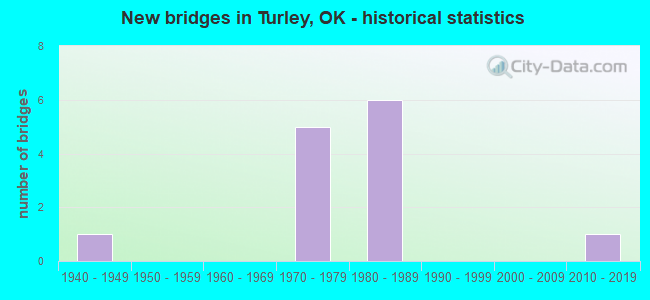
- New bridges - historical statistics
- 11940-1949
- 51970-1979
- 61980-1989
- 12010-2019


- Bridge Condition - Deck
- 44.4%Good
- 44.4%Satisfactory
- 11.1%Fair

- Bridge Condition - Superstructure
- 22.2%Very good
- 33.3%Good
- 22.2%Satisfactory
- 22.2%Fair

- Bridge Condition - Substructure
- 11.1%Very good
- 33.3%Good
- 55.6%Fair

- Bridge Condition - Channel
- 37.5%Very good
- 25.0%Good
- 37.5%Satisfactory
Find on map >> Show street view
Structure Number: 9051, Location: 10.9 MI S WASH. C/L (Lat: 36.276331, Lng: -95.973728), Route carried "on" structure: State highway 11, Year Built: 1940, Status: Open, Structure Length: 1.25m (4.10ft), Average Daily Traffic: 3,000 (year 2020), Truck Traffic: 5%, Average Future Daily Traffic: 4,800 (year 2040), Design Load: H 20, Features Intersected: CREEK
Minimum Vertical Clearance: 30+ m (98+ ft), Kilometerpoint: 17.555, Lanes on structure: 2, Owner: State Highway Agency, Approaching Roadway Width: 11.0m (36.1ft), Material/Design: Concrete, Design/Construction: Culvert, Number Of Spans In Main Unit: 3, Length of Maximum Span: 4.3m (14.1ft)
Condition: Channel: Satisfactory, Culverts: Good, Operating Rating: 33.0 metric tons, Method Used To Determine Operating Rating: Load and Resistance Factor (LRFR), Inventory Rating: 25.5 metric tons, Method Used To Determine Inventory Rating: Load and Resistance Factor (LRFR), Structural Evaluation: Equal to present minimum criteria, Waterway Adequacy: Somewhat better than minimum adequacy, Approach Roadway Alignment: Equal to present desirable criteria, Length Of Structure Improvement: 1.25m (4.10ft), Designated Inspection Frequency: Every 24 months, Inspection Date: December 2020, Bridge Improvement Cost: $230,000, Roadway Improvement Cost: $380,000, Total Project Cost: $644,000 ( Estimate for 2015)
Find on map >> Show street view
Structure Number: 1813, Location: 0.8 MI N 56 ST (Lat: 36.245333, Lng: -95.937189), Route carried "on" structure: US 75, Year Built: 1971, Status: Open, Structure Length: 10.94m (35.89ft), Average Daily Traffic: 16,400 (year 2020), Truck Traffic: 8%, Average Future Daily Traffic: 26,240 (year 2040), Design Load: HS 20, Features Intersected: BIRD CREEK
Minimum Vertical Clearance: 30+ m (98+ ft), Kilometerpoint: 17.659, Lanes on structure: 2, Base Highway Network: Yes, Owner: State Highway Agency, Approaching Roadway Width: 12.2m (40.0ft), Skew: 10 degrees, Material/Design: Prestressed concrete, Design/Construction: Stringer/Multi-beam, Number Of Spans In Main Unit: 4, Length of Maximum Span: 30.5m (100.1ft), Curb-To-Curb Width: 12.2m (40.0ft), Out-to-Out Width: 12.8m (42.0ft)
Condition: Deck: Satisfactory, Superstructure: Fair, Substructure: Fair, Channel: Satisfactory, Operating Rating: 64.3 metric tons, Method Used To Determine Operating Rating: Load Factor (LF), Inventory Rating: 37.6 metric tons, Method Used To Determine Inventory Rating: Load Factor (LF), Structural Evaluation: Somewhat better than minimum adequacy, Deck Geometry: Better than present minimum criteria, Waterway Adequacy: Equal to present desirable criteria, Approach Roadway Alignment: Equal to present desirable criteria, Length Of Structure Improvement: 12.28m (40.29ft), Designated Inspection Frequency: Every 24 months, Inspection Date: July 2021, Bridge Improvement Cost: $1,575,000, Roadway Improvement Cost: $2,599,000, Total Project Cost: $4,411,000 ( Estimate for 2015), Deck Structure Type: Concrete Cast-file-Place, Wearing Surface/Protective System: Wearing Surface: Monolithic Concrete
Find on map >> Show street view
Structure Number: 18135, Location: 0.4 MI N 56 ST (Lat: 36.240467, Lng: -95.943106), Route carried "on" structure: US 75, Year Built: 1971, Status: Open, Structure Length: 12.19m (39.99ft), Average Daily Traffic: 16,400 (year 2020), Truck Traffic: 8%, Average Future Daily Traffic: 26,240 (year 2040), Design Load: HS 20, Features Intersected: BIRD CREEK O'FLOW
Minimum Vertical Clearance: 30+ m (98+ ft), Kilometerpoint: 10.218, Lanes on structure: 3, Base Highway Network: Yes, Owner: State Highway Agency, Approaching Roadway Width: 18.3m (60.0ft), Skew: 10 degrees, Material/Design: Prestressed concrete, Design/Construction: Stringer/Multi-beam, Number Of Spans In Main Unit: 8, Length of Maximum Span: 15.2m (49.9ft), Curb-To-Curb Width: 16.7m (54.8ft), Out-to-Out Width: 17.2m (56.4ft)
Condition: Deck: Fair, Superstructure: Satisfactory, Substructure: Fair, Channel: Very good, Operating Rating: 42.2 metric tons, Method Used To Determine Operating Rating: Load Factor (LF), Inventory Rating: 25.3 metric tons, Method Used To Determine Inventory Rating: Load Factor (LF), Structural Evaluation: Somewhat better than minimum adequacy, Deck Geometry: Equal to present minimum criteria, Waterway Adequacy: Better than present minimum criteria, Approach Roadway Alignment: Equal to present desirable criteria, Length Of Structure Improvement: 12.99m (42.62ft), Designated Inspection Frequency: Every 24 months, Inspection Date: November 2020, Bridge Improvement Cost: $2,332,000, Roadway Improvement Cost: $3,848,000, Total Project Cost: $6,530,000 ( Estimate for 2015), Deck Structure Type: Concrete Cast-file-Place, Wearing Surface/Protective System: Wearing Surface: Monolithic Concrete
Find on map >> Show street view
Structure Number: 18139, Location: 0.6 MI N 56 ST (Lat: 36.242725, Lng: -95.940492), Route carried "on" structure: US 75, Year Built: 1971, Status: Open, Structure Length: 14.49m (47.54ft), Average Daily Traffic: 16,400 (year 2020), Truck Traffic: 8%, Average Future Daily Traffic: 26,240 (year 2040), Design Load: HS 20, Features Intersected: BIRD CREEK O'FL & RD UND
Minimum Vertical Clearance: 30+ m (98+ ft), Kilometerpoint: 17.012, Lanes on structure: 2, Lanes under structure: 2, Base Highway Network: Yes, Owner: State Highway Agency, Approaching Roadway Width: 15.2m (49.9ft), Skew: 10 degrees, Material/Design: Prestressed concrete, Design/Construction: Stringer/Multi-beam, Number Of Spans In Main Unit: 9, Number Of Approach Spans: 1, Length of Maximum Span: 15.3m (50.2ft), Curb-To-Curb Width: 14.2m (46.6ft), Out-to-Out Width: 15.2m (49.9ft)
Condition: Deck: Satisfactory, Superstructure: Satisfactory, Substructure: Fair, Channel: Good, Operating Rating: 39.3 metric tons, Method Used To Determine Operating Rating: Load Factor (LF), Inventory Rating: 23.5 metric tons, Method Used To Determine Inventory Rating: Load Factor (LF), Structural Evaluation: Somewhat better than minimum adequacy, Deck Geometry: Superior to present desirable criteria, Underclear: High priority of replacement, Waterway Adequacy: Better than present minimum criteria, Approach Roadway Alignment: Equal to present desirable criteria, Length Of Structure Improvement: 14.48m (47.51ft), Designated Inspection Frequency: Every 24 months, Inspection Date: November 2020, Bridge Improvement Cost: $1,857,000, Roadway Improvement Cost: $3,065,000, Total Project Cost: $5,201,000 ( Estimate for 2015), Deck Structure Type: Concrete Cast-file-Place, Wearing Surface/Protective System: Wearing Surface: Monolithic Concrete
Find on map >> Show street view
Structure Number: 19062, Location: 23.66 MI'S S. JCT I-40 (Lat: 35.101667, Lng: -95.889167), Route carried "on" structure: County highway 6118, Year Built: 1975, Status: Open, Structure Length: 4.94m (16.21ft), Average Daily Traffic: 100 (year 2020), Truck Traffic: 15%, Average Future Daily Traffic: 160 (year 2040), Design Load: H 15, Features Intersected: IND. NATION TP UNDER
Minimum Vertical Clearance: 30+ m (98+ ft), Kilometerpoint: 28.801, Lanes on structure: 2, Lanes under structure: 4, Owner: State Toll Authority, Approaching Roadway Width: 6.4m (21.0ft), Skew: 1 degrees, Material/Design: Prestressed concrete, Design/Construction: Stringer/Multi-beam, Number Of Spans In Main Unit: 4, Length of Maximum Span: 13.4m (44.0ft), Curb-To-Curb Width: 5.5m (18.0ft), Out-to-Out Width: 7.0m (23.0ft)
Condition: Deck: Good, Superstructure: Very good, Substructure: Good, Operating Rating: 68.0 metric tons, Method Used To Determine Operating Rating: Load Factor (LF), Inventory Rating: 40.8 metric tons, Method Used To Determine Inventory Rating: Load Factor (LF), Structural Evaluation: Better than present minimum criteria, Deck Geometry: Meets minimum limits, Underclear: Somewhat better than minimum adequacy, Approach Roadway Alignment: Somewhat better than minimum adequacy, Length Of Structure Improvement: 4.94m (16.21ft), Designated Inspection Frequency: Every 24 months, Inspection Date: June 2021, Bridge Improvement Cost: $618,000, Roadway Improvement Cost: $927,000, Total Project Cost: $1,770,000 ( Estimate for 2015), Deck Structure Type: Concrete Cast-file-Place, Wearing Surface/Protective System: Wearing Surface: Monolithic Concrete
Find on map >> Show street view
Structure Number: 22404, Location: 7.3 MI N OF I-244 (Lat: 36.249444, Lng: -95.931667), Route carried "on" structure: City street , Year Built: 1989, Status: Open, Structure Length: 9.14m (29.99ft), Average Daily Traffic: 500 (year 2020), Truck Traffic: 10%, Average Future Daily Traffic: 800 (year 2040), Design Load: HS 20, Features Intersected: U.S. 75 UNDER, Facility Carried by Structure: 66TH ST N.
Minimum Vertical Clearance: 30+ m (98+ ft), Kilometerpoint: 11.779, Lanes on structure: 2, Lanes under structure: 4, Owner: State Highway Agency, Approaching Roadway Width: 20.7m (67.9ft), Skew: 24 degrees, Material/Design: Prestressed concrete continuous, Design/Construction: Box Beam or Girders - Multiple, Number Of Spans In Main Unit: 2, Length of Maximum Span: 48.2m (158.1ft), Curb-To-Curb Width: 20.7m (67.9ft), Out-to-Out Width: 21.6m (70.9ft)
Condition: Deck: Good, Superstructure: Good, Substructure: Good, Operating Rating: 44.2 metric tons, Method Used To Determine Operating Rating: Load Factor (LF), Inventory Rating: 32.5 metric tons, Method Used To Determine Inventory Rating: Load Factor (LF), Structural Evaluation: Better than present minimum criteria, Deck Geometry: Superior to present desirable criteria, Underclear: Equal to present minimum criteria, Approach Roadway Alignment: Equal to present desirable criteria, Length Of Structure Improvement: 10.36m (33.99ft), Designated Inspection Frequency: Every 24 months, Inspection Date: December 2020, Bridge Improvement Cost: $825,000, Roadway Improvement Cost: $1,362,000, Total Project Cost: $2,311,000 ( Estimate for 2015), Deck Structure Type: Concrete Cast-file-Place, Wearing Surface/Protective System: Wearing Surface: Monolithic Concrete, Membrane: Epoxy, Deck Protection: Epoxy Coated Reinforcing
Find on map >> Show street view
Structure Number: 22406, Location: 6.8 MI N OF I-244 (Lat: 36.245553, Lng: -95.937456), Route carried "on" structure: US 75, Year Built: 1989, Status: Open, Structure Length: 11.22m (36.81ft), Average Daily Traffic: 18,250 (year 2020), Truck Traffic: 8%, Average Future Daily Traffic: 29,200 (year 2040), Design Load: HS 20, Features Intersected: BIRD CREEK
Minimum Vertical Clearance: 30+ m (98+ ft), Kilometerpoint: 17.659, Lanes on structure: 2, Base Highway Network: Yes, Owner: State Highway Agency, Approaching Roadway Width: 12.2m (40.0ft), Skew: 10 degrees, Material/Design: Prestressed concrete, Design/Construction: Stringer/Multi-beam, Number Of Spans In Main Unit: 4, Length of Maximum Span: 30.5m (100.1ft), Curb-To-Curb Width: 12.2m (40.0ft), Out-to-Out Width: 12.8m (42.0ft)
Condition: Deck: Satisfactory, Superstructure: Fair, Substructure: Fair, Channel: Satisfactory, Operating Rating: 44.5 metric tons, Method Used To Determine Operating Rating: Load and Resistance Factor (LRFR), Inventory Rating: 30.1 metric tons, Method Used To Determine Inventory Rating: Load and Resistance Factor (LRFR), Structural Evaluation: Somewhat better than minimum adequacy, Deck Geometry: Better than present minimum criteria, Waterway Adequacy: Equal to present desirable criteria, Approach Roadway Alignment: Equal to present desirable criteria, Length Of Structure Improvement: 12.43m (40.78ft), Designated Inspection Frequency: Every 24 months, Inspection Date: July 2021, Bridge Improvement Cost: $1,594,000, Roadway Improvement Cost: $2,631,000, Total Project Cost: $4,464,000 ( Estimate for 2015), Deck Structure Type: Concrete Cast-file-Place, Wearing Surface/Protective System: Wearing Surface: Monolithic Concrete, Deck Protection: Epoxy Coated Reinforcing
Find on map >> Show street view
Structure Number: 22409, Location: 6.3 MI N OF I-244 (Lat: 36.240653, Lng: -95.943431), Route carried "on" structure: US 75, Year Built: 1989, Status: Open, Structure Length: 12.62m (41.40ft), Average Daily Traffic: 18,250 (year 2020), Truck Traffic: 8%, Average Future Daily Traffic: 29,200 (year 2040), Design Load: HS 20, Features Intersected: BIRD CREEK O'FLOW
Minimum Vertical Clearance: 30+ m (98+ ft), Kilometerpoint: 10.218, Lanes on structure: 2, Base Highway Network: Yes, Owner: State Highway Agency, Approaching Roadway Width: 12.2m (40.0ft), Skew: 10 degrees, Material/Design: Prestressed concrete, Design/Construction: Stringer/Multi-beam, Number Of Spans In Main Unit: 8, Length of Maximum Span: 16.2m (53.1ft), Curb-To-Curb Width: 11.6m (38.1ft), Out-to-Out Width: 12.5m (41.0ft)
Condition: Deck: Good, Superstructure: Good, Substructure: Fair, Channel: Very good, Operating Rating: 47.8 metric tons, Method Used To Determine Operating Rating: Load Factor (LF), Inventory Rating: 28.6 metric tons, Method Used To Determine Inventory Rating: Load Factor (LF), Structural Evaluation: Somewhat better than minimum adequacy, Deck Geometry: Equal to present minimum criteria, Waterway Adequacy: Better than present minimum criteria, Approach Roadway Alignment: Equal to present desirable criteria, Length Of Structure Improvement: 13.23m (43.41ft), Designated Inspection Frequency: Every 24 months, Inspection Date: November 2020, Bridge Improvement Cost: $1,697,000, Roadway Improvement Cost: $2,800,000, Total Project Cost: $4,751,000 ( Estimate for 2015), Deck Structure Type: Concrete Cast-file-Place, Wearing Surface/Protective System: Wearing Surface: Monolithic Concrete, Membrane: Epoxy, Deck Protection: Epoxy Coated Reinforcing
Find on map >> Show street view
Structure Number: 22411, Location: 6.5 MI N OF I-244 (Lat: 36.242942, Lng: -95.940750), Route carried "on" structure: US 75, Year Built: 1989, Status: Open, Structure Length: 14.58m (47.83ft), Average Daily Traffic: 18,250 (year 2020), Truck Traffic: 8%, Average Future Daily Traffic: 29,200 (year 2040), Design Load: HS 20, Features Intersected: BIRD CREEK O'FL & RD UND
Minimum Vertical Clearance: 30+ m (98+ ft), Kilometerpoint: 10.572, Lanes on structure: 2, Lanes under structure: 2, Base Highway Network: Yes, Owner: State Highway Agency, Approaching Roadway Width: 11.6m (38.1ft), Skew: 10 degrees, Material/Design: Prestressed concrete, Design/Construction: Stringer/Multi-beam, Number Of Spans In Main Unit: 9, Number Of Approach Spans: 1, Length of Maximum Span: 15.5m (50.9ft), Curb-To-Curb Width: 11.6m (38.1ft), Out-to-Out Width: 12.5m (41.0ft)
Condition: Deck: Satisfactory, Superstructure: Good, Substructure: Good, Channel: Good, Operating Rating: 49.1 metric tons, Method Used To Determine Operating Rating: Load Factor (LF), Inventory Rating: 29.4 metric tons, Method Used To Determine Inventory Rating: Load Factor (LF), Structural Evaluation: Better than present minimum criteria, Deck Geometry: Equal to present minimum criteria, Underclear: High priority of replacement, Waterway Adequacy: Equal to present desirable criteria, Approach Roadway Alignment: Equal to present desirable criteria, Length Of Structure Improvement: 14.57m (47.80ft), Designated Inspection Frequency: Every 24 months, Inspection Date: November 2020, Bridge Improvement Cost: $1,869,000, Roadway Improvement Cost: $3,084,000, Total Project Cost: $5,233,000 ( Estimate for 2015), Deck Structure Type: Concrete Cast-file-Place, Wearing Surface/Protective System: Wearing Surface: Monolithic Concrete, Membrane: Epoxy, Deck Protection: Epoxy Coated Reinforcing
Find on map >> Show street view
Structure Number: 30685, Location: 11 S OF WASHINGTON C/L (Lat: 36.273611, Lng: -95.973611), Route carried "on" structure: State highway 11, Year Built: 2016, Status: Open, Structure Length: 6.11m (20.05ft), Average Daily Traffic: 3,400 (year 2020), Truck Traffic: 8%, Average Future Daily Traffic: 4,760 (year 2040), Design Load: HL 93, Features Intersected: DELAWARE CREEK
Minimum Vertical Clearance: 30+ m (98+ ft), Kilometerpoint: 17.844, Lanes on structure: 2, Owner: State Highway Agency, Approaching Roadway Width: 12.2m (40.0ft), Material/Design: Prestressed concrete, Design/Construction: Stringer/Multi-beam, Number Of Spans In Main Unit: 3, Length of Maximum Span: 30.5m (100.1ft), Curb-To-Curb Width: 12.2m (40.0ft), Out-to-Out Width: 12.8m (42.0ft)
Condition: Deck: Good, Superstructure: Very good, Substructure: Very good, Channel: Very good, Operating Rating: 75.9 metric tons, Method Used To Determine Operating Rating: Load and Resistance Factor (LRFR), Inventory Rating: 55.1 metric tons, Method Used To Determine Inventory Rating: Load and Resistance Factor (LRFR), Structural Evaluation: Equal to present desirable criteria, Deck Geometry: Equal to present minimum criteria, Waterway Adequacy: Equal to present desirable criteria, Approach Roadway Alignment: Equal to present desirable criteria, Designated Inspection Frequency: Every 24 months, Inspection Date: December 2020, Deck Structure Type: Concrete Cast-file-Place, Wearing Surface/Protective System: Wearing Surface: Monolithic Concrete, Membrane: Epoxy, Deck Protection: Epoxy Coated Reinforcing
Find on map >> Show street view
Structure Number: 18139, Location: 0.6 MI N 56 ST (Lat: 36.242725, Lng: -95.940492), Route carried "under" structure: City street , Year Built: 1971, Structure Length: 0. m, Average Daily Traffic: 500 (year 2020), Truck Traffic: 15%, Features Intersected: BIRD CREEK O'FL & RD UND, Facility Carried by Structure: U.S. 75 NB
Minimum Vertical Clearance: 3.81m (12.50ft), Kilometerpoint: 10.572, Lanes on structure: 2, Lanes under structure: 1, Material/Design: Prestressed concrete, Design/Construction: Stringer/Multi-beam, Length of Maximum Span: 15.3m (50.2ft)
Find on map >> Show street view
Structure Number: 22404, Location: 7.3 MI N OF I-244 (Lat: 36.249444, Lng: -95.931667), Route carried "under" structure: US 75, Year Built: 1989, Structure Length: 0. m, Average Daily Traffic: 36,500 (year 2020), Truck Traffic: 8%, Features Intersected: U.S. 75 UNDER, Facility Carried by Structure: 66TH ST N.
Minimum Vertical Clearance: 5.03m (16.50ft), Kilometerpoint: 11.779, Lanes on structure: 2, Lanes under structure: 4, Material/Design: Prestressed concrete continuous, Design/Construction: Box Beam or Girders - Multiple, Length of Maximum Span: 48.2m (158.1ft)
Find on map >> Show street view
Structure Number: 22411, Location: 6.5 MI N OF I-244 (Lat: 36.242942, Lng: -95.940750), Route carried "under" structure: City street , Year Built: 1989, Structure Length: 0. m, Average Daily Traffic: 500 (year 2020), Truck Traffic: 15%, Features Intersected: BIRD CREEK O'FL & RD UND, Facility Carried by Structure: U.S. 75 SB
Minimum Vertical Clearance: 3.66m (12.01ft), Kilometerpoint: 10.572, Lanes on structure: 2, Lanes under structure: 1, Material/Design: Prestressed concrete, Design/Construction: Stringer/Multi-beam, Length of Maximum Span: 15.5m (50.9ft)