Bridge Statistics for Turnersville, New Jersey (NJ)
Condition, Traffic, Stress, Structural Evaluation, Project Costs
- National Bridge Inventory (NBI) Statistics
- 12Number of bridges
- 59ft / 17.8mTotal length
- $3,700,000Total costs
- 396,639Total average daily traffic
- 18,239Total average daily truck traffic
- National Bridge Inventory (NBI) Registered Bridges for Turnersville
- No street view available for this location
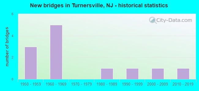
- New bridges - historical statistics
- 31950-1959
- 51960-1969
- 11980-1989
- 11990-1999
- 12000-2009
- 12010-2019


- Bridge Condition - Deck
- 25.0%Good
- 75.0%Satisfactory

- Bridge Condition - Superstructure
- 16.7%Excellent
- 33.3%Good
- 16.7%Satisfactory
- 33.3%Fair

- Bridge Condition - Substructure
- 16.7%Excellent
- 33.3%Good
- 50.0%Satisfactory

- Bridge Condition - Channel
- 16.7%Very good
- 33.3%Good
- 33.3%Satisfactory
- 16.7%Fair

- Bridge Condition - Culverts
- 66.7%Satisfactory
- 33.3%Fair
Find on map >> Show street view
Structure Number: 41115, Location: .30 MILE NORTH OF 168 JCT (Lat: 39.771419, Lng: -75.048581), Route carried "on" structure: State highway 42, Year Built: 1958, Year Reconstructed: 1964, Status: Open, Structure Length: 2.47m (8.10ft), Average Daily Traffic: 74,192 (year 2020), Truck Traffic: 5%, Average Future Daily Traffic: 890,307 (year 2040), Design Load: HS 20, Features Intersected: SICKLERVILLE RD (CR 705)
Minimum Vertical Clearance: 30+ m (98+ ft), Kilometerpoint: 10.654, Lanes on structure: 9, Lanes under structure: 2, Base Highway Network: Yes, Owner: State Highway Agency, Approaching Roadway Width: 42.1m (138.1ft), Skew: 33 degrees, Material/Design: Steel, Design/Construction: Stringer/Multi-beam, Number Of Spans In Main Unit: 1, Length of Maximum Span: 22.6m (74.1ft), Curb or Sidewalk Widths: Left: 0.2m (0.7ft), Right: 0.2m (0.7ft), Curb-To-Curb Width: 41.5m (136.2ft), Out-to-Out Width: 49.4m (162.1ft)
Condition: Deck: Satisfactory, Superstructure: Good, Substructure: Satisfactory, Operating Rating: 77.1 metric tons, Method Used To Determine Operating Rating: Load Factor (LF), Inventory Rating: 46.3 metric tons, Method Used To Determine Inventory Rating: Load Factor (LF), Structural Evaluation: Equal to present minimum criteria, Deck Geometry: Superior to present desirable criteria, Underclear: Somewhat better than minimum adequacy, Approach Roadway Alignment: Equal to present desirable criteria, Designated Inspection Frequency: Every 24 months, Inspection Date: July 2020, Deck Structure Type: Concrete Cast-file-Place, Wearing Surface/Protective System: Wearing Surface: Bituminous
Find on map >> Show street view
Structure Number: 80315, Location: 0.3 MI NO. OF 168 JCT. (Lat: 39.771181, Lng: -75.048550), Route carried "on" structure: State highway 42, Year Built: 1958, Status: Open, Structure Length: 0.98m (3.22ft), Average Daily Traffic: 49,859 (year 2020), Truck Traffic: 5%, Average Future Daily Traffic: 60,838 (year 2040), Design Load: HS 20, Features Intersected: S.BR.BIG TIMBER CREEK
Minimum Vertical Clearance: 30+ m (98+ ft), Kilometerpoint: 10.606, Lanes on structure: 9, Base Highway Network: Yes, Owner: State Highway Agency, Approaching Roadway Width: 42.7m (140.1ft), Skew: 31 degrees, Material/Design: Concrete, Design/Construction: Culvert, Number Of Spans In Main Unit: 2, Length of Maximum Span: 4.6m (15.1ft)
Condition: Channel: Satisfactory, Culverts: Satisfactory, Structural Evaluation: Equal to present minimum criteria, Waterway Adequacy: Equal to present minimum criteria, Approach Roadway Alignment: Equal to present desirable criteria, Designated Inspection Frequency: Every 24 months, Inspection Date: October 2020
Find on map >> Show street view
Structure Number: 804L04, Location: 0.4 MI N of AC Expressway (Lat: 39.776439, Lng: -75.054331), Route carried "on" structure: City street , Year Built: 2008, Status: Open, Structure Length: 0.79m (2.59ft), Average Daily Traffic: 10,624 (year 2020), Truck Traffic: 1%, Average Future Daily Traffic: 12,748 (year 2040), Features Intersected: BELLS LAKE BRANCH, Facility Carried by Structure: WILSON ROAD
Minimum Vertical Clearance: 30+ m (98+ ft), Kilometerpoint: 0.000, Lanes on structure: 2, Owner: County Highway Agency, Approaching Roadway Width: 12.2m (40.0ft), Material/Design: Concrete, Design/Construction: Frame, Number Of Spans In Main Unit: 1, Length of Maximum Span: 7.9m (25.9ft), Curb or Sidewalk Widths: Left: 1.5m (4.9ft), Right: 0.0m, Curb-To-Curb Width: 12.2m (40.0ft), Out-to-Out Width: 14.6m (47.9ft)
Condition: Superstructure: Good, Substructure: Good, Channel: Good, Operating Rating: 50.5 metric tons, Method Used To Determine Operating Rating: Load and Resistance Factor Rating (LRFR) rating reported by rating factor(RF) method using HL-93 loadings, Inventory Rating: 38.9 metric tons, Method Used To Determine Inventory Rating: Load and Resistance Factor Rating (LRFR) rating reported by rating factor(RF) method using HL-93 loadings, Structural Evaluation: Better than present minimum criteria, Deck Geometry: Somewhat better than minimum adequacy, Waterway Adequacy: Equal to present desirable criteria, Approach Roadway Alignment: Equal to present minimum criteria, Designated Inspection Frequency: Every 24 months, Inspection Date: October 2020
Find on map >> Show street view
Structure Number: 804L05, Location: .18 Mi N. of NJ168 (Lat: 39.774781, Lng: -75.054011), Route carried "on" structure: County highway 705, Year Built: 1998, Status: Open, Structure Length: 0.61m (2.00ft), Average Daily Traffic: 12,398 (year 2020), Truck Traffic: 4%, Average Future Daily Traffic: 14,877 (year 2040), Design Load: HS 25 or greater, Features Intersected: BELLS LAKE BRANCH, Facility Carried by Structure: COUNTY HOUSE RD
Minimum Vertical Clearance: 30+ m (98+ ft), Kilometerpoint: 0.515, Lanes on structure: 2, Owner: County Highway Agency, Approaching Roadway Width: 9.8m (32.2ft), Material/Design: Steel, Design/Construction: Culvert, Number Of Spans In Main Unit: 1, Length of Maximum Span: 6.1m (20.0ft), Curb or Sidewalk Widths: Left: 1.8m (5.9ft), Right: 1.8m (5.9ft), Curb-To-Curb Width: 12.2m (40.0ft), Out-to-Out Width: 16.5m (54.1ft)
Condition: Channel: Fair, Culverts: Fair, Operating Rating: 52.6 metric tons, Method Used To Determine Operating Rating: Load Factor (LF), Inventory Rating: 46.3 metric tons, Method Used To Determine Inventory Rating: Load Factor (LF), Structural Evaluation: Somewhat better than minimum adequacy, Deck Geometry: Somewhat better than minimum adequacy, Waterway Adequacy: Equal to present desirable criteria, Approach Roadway Alignment: Equal to present desirable criteria, Designated Inspection Frequency: Every 24 months, Inspection Date: October 2020
Find on map >> Show street view
Structure Number: 805L15, Location: 0.4 Mi. West of Rt. 42 (Lat: 39.760350, Lng: -75.055050), Route carried "on" structure: City street , Year Built: 1986, Status: Open, Structure Length: 0.79m (2.59ft), Average Daily Traffic: 3,929 (year 2020), Truck Traffic: 1%, Average Future Daily Traffic: 4,714 (year 2040), Design Load: HS 20, Features Intersected: BELLS LAKE BRANCH, Facility Carried by Structure: SHOPPERS LANE
Minimum Vertical Clearance: 30+ m (98+ ft), Kilometerpoint: 0.000, Lanes on structure: 2, Owner: County Highway Agency, Approaching Roadway Width: 8.5m (27.9ft), Material/Design: Wood or Timber, Design/Construction: Slab, Number Of Spans In Main Unit: 1, Length of Maximum Span: 7.6m (24.9ft), Curb or Sidewalk Widths: Left: 1.3m (4.3ft), Right: 0.3m (1.0ft), Curb-To-Curb Width: 8.5m (27.9ft), Out-to-Out Width: 9.1m (29.9ft)
Condition: Deck: Satisfactory, Superstructure: Satisfactory, Substructure: Good, Channel: Satisfactory, Operating Rating: 40.8 metric tons, Method Used To Determine Operating Rating: Allowable Stress (AS), Inventory Rating: 26.3 metric tons, Method Used To Determine Inventory Rating: Allowable Stress (AS), Structural Evaluation: Equal to present minimum criteria, Deck Geometry: Meets minimum limits, Waterway Adequacy: Equal to present desirable criteria, Approach Roadway Alignment: Equal to present desirable criteria, Designated Inspection Frequency: Every 24 months, Inspection Date: October 2020, Deck Structure Type: Wood or Timber, Wearing Surface/Protective System: Wearing Surface: Bituminous
Find on map >> Show street view
Structure Number: 81915, Location: 0.5 MILE N. OF CR. 705 (Lat: 39.780089, Lng: -75.053331), Route carried "on" structure: State highway 168, Year Built: 2019, Status: Open, Structure Length: 0.79m (2.59ft), Average Daily Traffic: 12,102 (year 2021), Truck Traffic: 4%, Average Future Daily Traffic: 14,522 (year 2041), Design Load: HL 93, Features Intersected: GRENLOCH LAKE
Minimum Vertical Clearance: 30+ m (98+ ft), Kilometerpoint: 1.207, Lanes on structure: 3, Base Highway Network: Yes, Owner: State Highway Agency, Approaching Roadway Width: 21.9m (71.9ft), Material/Design: Concrete, Design/Construction: Frame, Number Of Spans In Main Unit: 1, Length of Maximum Span: 7.3m (24.0ft), Curb or Sidewalk Widths: Left: 1.3m (4.3ft), Right: 3.0m (9.8ft), Curb-To-Curb Width: 22.0m (72.2ft), Out-to-Out Width: 27.5m (90.2ft)
Condition: Superstructure: Excellent, Substructure: Excellent, Channel: Very good, Operating Rating: 72.3 metric tons, Method Used To Determine Operating Rating: Load and Resistance Factor Rating (LRFR) rating reported by rating factor(RF) method using HL-93 loadings, Inventory Rating: 55.7 metric tons, Method Used To Determine Inventory Rating: Load and Resistance Factor Rating (LRFR) rating reported by rating factor(RF) method using HL-93 loadings, Structural Evaluation: Superior to present desirable criteria, Deck Geometry: Superior to present desirable criteria, Waterway Adequacy: Equal to present minimum criteria, Approach Roadway Alignment: Equal to present desirable criteria, Length Of Structure Improvement: 1.34m (4.40ft), Designated Inspection Frequency: Every 24 months, Underwater Inspection Frequency: Every 24 months, Inspection Date: October 2021, Underwater Inspection Date: April 2021, Bridge Improvement Cost: $1,282,000, Roadway Improvement Cost: $128,000, Total Project Cost: $2,186,000 ( Estimate for 2018)
Find on map >> Show street view
Structure Number: 350429, Location: 1 MILE EAST OF RT 42 (Lat: 39.756669, Lng: -75.036669), Route carried "on" structure: Other road ACE, Year Built: 1963, Status: Open, Structure Length: 1.01m (3.31ft), Average Daily Traffic: 84,399 (year 2012), Truck Traffic: 5%, Average Future Daily Traffic: 115,652 (year 2032), Design Load: HS 20, Features Intersected: S.BRANCH BIG TIMBER CRK, Facility Carried by Structure: A.C. EXPRESSWAY
Minimum Vertical Clearance: 30+ m (98+ ft), Kilometerpoint: 69.041, Lanes on structure: 4, Base Highway Network: Yes, Toll: On toll road, Owner: State Toll Authority, Maintenance Responsibility: Private, Approaching Roadway Width: 27.1m (88.9ft), Skew: 4 degrees, Material/Design: Concrete, Design/Construction: Culvert, Number Of Spans In Main Unit: 1, Length of Maximum Span: 6.7m (22.0ft)
Condition: Channel: Good, Culverts: Satisfactory, Operating Rating: 89.8 metric tons, Method Used To Determine Operating Rating: Load Factor (LF), Inventory Rating: 57.2 metric tons, Method Used To Determine Inventory Rating: Load Factor (LF), Structural Evaluation: Equal to present minimum criteria, Waterway Adequacy: Superior to present desirable criteria, Approach Roadway Alignment: Better than present minimum criteria, Designated Inspection Frequency: Every 24 months, Inspection Date: March 2020, Wearing Surface/Protective System: Wearing Surface: Bituminous
Find on map >> Show street view
Structure Number: 350440N, Location: INT. OF ACE WB & 42 (Lat: 39.768331, Lng: -75.048331), Route carried "on" structure: Other road ACE, Year Built: 1963, Status: Open, Structure Length: 5.82m (19.09ft), Average Daily Traffic: 36,500 (year 2006), Truck Traffic: 5%, Average Future Daily Traffic: 50,000 (year 2026), Design Load: HS 20, Features Intersected: ROUTE 42, Facility Carried by Structure: A.C. EXPRESSWAY WB
Minimum Vertical Clearance: 30+ m (98+ ft), Kilometerpoint: 70.811, Lanes on structure: 2, Lanes under structure: 2, Base Highway Network: Yes, Toll: On toll road, Owner: State Toll Authority, Maintenance Responsibility: Private, Approaching Roadway Width: 14.6m (47.9ft), Skew: 3 degrees, Material/Design: Steel, Design/Construction: Stringer/Multi-beam, Number Of Spans In Main Unit: 3, Length of Maximum Span: 29.3m (96.1ft), Curb or Sidewalk Widths: Left: 1.2m (3.9ft), Right: 1.5m (4.9ft), Curb-To-Curb Width: 10.1m (33.1ft), Out-to-Out Width: 11.6m (38.1ft)
Condition: Deck: Good, Superstructure: Fair, Substructure: Satisfactory, Operating Rating: 55.3 metric tons, Method Used To Determine Operating Rating: Load Factor (LF), Inventory Rating: 32.7 metric tons, Method Used To Determine Inventory Rating: Load Factor (LF), Structural Evaluation: Somewhat better than minimum adequacy, Deck Geometry: High priority of corrective action, Underclear: Equal to present minimum criteria, Approach Roadway Alignment: Equal to present minimum criteria, Length Of Structure Improvement: 5.80m (19.03ft), Designated Inspection Frequency: Every 24 months, Inspection Date: March 2020, Bridge Improvement Cost: $607,000, Roadway Improvement Cost: $288,000, Total Project Cost: $895,000 ( Estimate for 2018), Deck Structure Type: Concrete Cast-file-Place, Wearing Surface/Protective System: Wearing Surface: Bituminous
Find on map >> Show street view
Structure Number: 350440S, Location: AT INT. OF ACE EB & 42 (Lat: 39.766669, Lng: -75.048331), Route carried "on" structure: Other road ACE, Year Built: 1963, Status: Open, Structure Length: 4.51m (14.80ft), Average Daily Traffic: 36,500 (year 2006), Truck Traffic: 5%, Average Future Daily Traffic: 50,000 (year 2026), Design Load: HS 20, Features Intersected: ROUTE 42, Facility Carried by Structure: A.C. EXPRESSWAY EB
Minimum Vertical Clearance: 30+ m (98+ ft), Kilometerpoint: 70.811, Lanes on structure: 2, Lanes under structure: 2, Base Highway Network: Yes, Toll: On toll road, Owner: State Toll Authority, Maintenance Responsibility: Private, Approaching Roadway Width: 14.6m (47.9ft), Skew: 4 degrees, Material/Design: Steel, Design/Construction: Stringer/Multi-beam, Number Of Spans In Main Unit: 3, Length of Maximum Span: 22.9m (75.1ft), Curb or Sidewalk Widths: Left: 1.2m (3.9ft), Right: 1.5m (4.9ft), Curb-To-Curb Width: 10.1m (33.1ft), Out-to-Out Width: 11.8m (38.7ft)
Condition: Deck: Satisfactory, Superstructure: Fair, Substructure: Satisfactory, Operating Rating: 59.0 metric tons, Method Used To Determine Operating Rating: Load Factor (LF), Inventory Rating: 35.4 metric tons, Method Used To Determine Inventory Rating: Load Factor (LF), Structural Evaluation: Somewhat better than minimum adequacy, Deck Geometry: High priority of corrective action, Underclear: Somewhat better than minimum adequacy, Approach Roadway Alignment: Better than present minimum criteria, Length Of Structure Improvement: 4.50m (14.76ft), Designated Inspection Frequency: Every 24 months, Inspection Date: March 2020, Bridge Improvement Cost: $391,000, Roadway Improvement Cost: $228,000, Total Project Cost: $619,000 ( Estimate for 2018), Deck Structure Type: Concrete Cast-file-Place, Wearing Surface/Protective System: Wearing Surface: Bituminous
Find on map >> Show street view
Structure Number: 41115, Location: .30 MILE NORTH OF 168 JCT (Lat: 39.771419, Lng: -75.048581), Route carried "under" structure: County highway 705, Year Built: 1958, Structure Length: 0. m, Average Daily Traffic: 11,486 (year 2020), Truck Traffic: 4%, Features Intersected: SICKLERVILLE RD (CR 705), Facility Carried by Structure: ROUTE NJ 42
Minimum Vertical Clearance: 4.40m (14.44ft), Kilometerpoint: 12.167, Lanes on structure: 9, Lanes under structure: 2, Material/Design: Steel, Design/Construction: Stringer/Multi-beam, Length of Maximum Span: 22.6m (74.1ft)
Find on map >> Show street view
Structure Number: 350440N, Location: INT. OF ACE WB & 42 (Lat: 39.768331, Lng: -75.048331), Route carried "under" structure: State highway 42, Year Built: 1963, Structure Length: 0. m, Average Daily Traffic: 32,650 (year 2006), Truck Traffic: 4%, Features Intersected: ROUTE 42, Facility Carried by Structure: A.C. EXPRESSWAY WB
Minimum Vertical Clearance: 4.62m (15.16ft), Kilometerpoint: 10.219, Lanes on structure: 2, Lanes under structure: 2, Toll: On toll road, Material/Design: Steel, Design/Construction: Stringer/Multi-beam, Length of Maximum Span: 29.3m (96.1ft)
Find on map >> Show street view
Structure Number: 350440S, Location: AT INT. OF ACE EB & 42 (Lat: 39.766669, Lng: -75.048331), Route carried "under" structure: State highway 42, Year Built: 1963, Structure Length: 0. m, Average Daily Traffic: 32,000 (year 2006), Truck Traffic: 4%, Features Intersected: ROUTE 42, Facility Carried by Structure: A.C. EXPRESSWAY EB
Minimum Vertical Clearance: 4.72m (15.49ft), Kilometerpoint: 10.171, Lanes on structure: 2, Lanes under structure: 2, Toll: On toll road, Material/Design: Steel, Design/Construction: Stringer/Multi-beam, Length of Maximum Span: 22.9m (75.1ft)