Bridge Statistics for Twin Falls, Idaho (ID)
Condition, Traffic, Stress, Structural Evaluation, Project Costs
- National Bridge Inventory (NBI) Statistics
- 30Number of bridges
- 446ft / 136mTotal length
- $34,410,000Total costs
- 202,480Total average daily traffic
- 21,945Total average daily truck traffic
- National Bridge Inventory (NBI) Registered Bridges for Twin Falls
- No street view available for this location
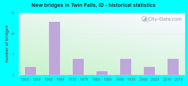
- New bridges - historical statistics
- 21950-1959
- 131960-1969
- 41970-1979
- 11980-1989
- 41990-1999
- 22000-2009
- 42010-2019


- Bridge Condition - Deck
- 4.3%Very good
- 30.4%Good
- 60.9%Satisfactory
- 4.3%Fair

- Bridge Condition - Superstructure
- 13.0%Very good
- 39.1%Good
- 47.8%Satisfactory

- Bridge Condition - Substructure
- 4.3%Very good
- 26.1%Good
- 65.2%Satisfactory
- 4.3%Fair

- Bridge Condition - Channel
- 9.1%Excellent
- 50.0%Very good
- 27.3%Good
- 13.6%Satisfactory

- Bridge Condition - Culverts
- 33.3%Satisfactory
- 33.3%Fair
- 33.3%Poor
Find on map >> Show street view
Structure Number: 13608, Location: US 30/US 93 JUNCTION (Lat: 42.563694, Lng: -114.575000), Route carried "on" structure: US 30, Year Built: 1997, Status: Open, Structure Length: 4.63m (15.19ft), Average Daily Traffic: 10,000 (year 2019), Truck Traffic: 4%, Average Future Daily Traffic: 15,000 (year 2039), Design Load: HS 25 or greater, Features Intersected: US 30/US 93 INTERCHANGE
Minimum Vertical Clearance: 30+ m (98+ ft), Kilometerpoint: 341.272, Lanes on structure: 4, Lanes under structure: 4, Base Highway Network: Yes (Inventory Route: US0, Subroute: 1), Owner: State Highway Agency, Approaching Roadway Width: 21.6m (70.9ft), Material/Design: Prestressed concrete, Design/Construction: Box Beam or Girders - Single/Spread, Number Of Spans In Main Unit: 1, Length of Maximum Span: 45.7m (149.9ft), Curb-To-Curb Width: 21.9m (71.9ft), Out-to-Out Width: 22.6m (74.1ft)
Condition: Deck: Satisfactory, Superstructure: Satisfactory, Substructure: Good, Operating Rating: 77.1 metric tons, Method Used To Determine Operating Rating: Load Factor (LF), Inventory Rating: 31.8 metric tons, Method Used To Determine Inventory Rating: Load Factor (LF), Structural Evaluation: Equal to present minimum criteria, Deck Geometry: Superior to present desirable criteria, Underclear: Equal to present minimum criteria, Approach Roadway Alignment: Equal to present desirable criteria, Designated Inspection Frequency: Every 24 months, Inspection Date: April 2021, Deck Structure Type: Concrete Cast-file-Place, Wearing Surface/Protective System: Wearing Surface: Epoxy Overlay, Deck Protection: Epoxy Coated Reinforcing
Find on map >> Show street view
Structure Number: 13635, Location: NEAR TWIN FALLS SECL (Lat: 42.548333, Lng: -114.440778), Route carried "on" structure: US 30, Year Built: 1960, Status: Open, Structure Length: 0.76m (2.49ft), Average Daily Traffic: 15,500 (year 2019), Truck Traffic: 7%, Average Future Daily Traffic: 23,250 (year 2039), Design Load: HS 20, Features Intersected: PERRINE COULEE CANAL
Minimum Vertical Clearance: 30+ m (98+ ft), Kilometerpoint: 353.438, Lanes on structure: 8, Base Highway Network: Yes (Inventory Route: US0, Subroute: 1), Owner: State Highway Agency, Approaching Roadway Width: 23.8m (78.1ft), Skew: 3 degrees, Material/Design: Concrete, Design/Construction: Frame, Number Of Spans In Main Unit: 1, Length of Maximum Span: 7.6m (24.9ft), Curb-To-Curb Width: 79.7m (261.5ft), Out-to-Out Width: 80.3m (263.5ft)
Condition: Deck: Satisfactory, Superstructure: Satisfactory, Substructure: Satisfactory, Channel: Very good, Operating Rating: 64.4 metric tons, Method Used To Determine Operating Rating: Load Factor (LF), Inventory Rating: 38.1 metric tons, Method Used To Determine Inventory Rating: Load Factor (LF), Structural Evaluation: Equal to present minimum criteria, Deck Geometry: Superior to present desirable criteria, Waterway Adequacy: Equal to present desirable criteria, Approach Roadway Alignment: Equal to present desirable criteria, Designated Inspection Frequency: Every 48 months, Inspection Date: March 2021, Deck Structure Type: Concrete Cast-file-Place, Wearing Surface/Protective System: Wearing Surface: Monolithic Concrete, Membrane: Preformed Fabric
Find on map >> Show street view
Structure Number: 1522, Location: 3.6 S. TWIN FALLS (Lat: 42.520278, Lng: -114.532306), Route carried "on" structure: State highway 74, Year Built: 1956, Status: Open, Structure Length: 2.38m (7.81ft), Average Daily Traffic: 1,500 (year 2019), Truck Traffic: 25%, Average Future Daily Traffic: 2,250 (year 2039), Design Load: HS 20, Features Intersected: LOW LINE CANAL
Minimum Vertical Clearance: 30+ m (98+ ft), Kilometerpoint: 3.925, Lanes on structure: 2, Owner: State Highway Agency, Approaching Roadway Width: 10.4m (34.1ft), Material/Design: Steel, Design/Construction: Stringer/Multi-beam, Number Of Spans In Main Unit: 1, Length of Maximum Span: 22.9m (75.1ft), Curb-To-Curb Width: 10.4m (34.1ft), Out-to-Out Width: 11.2m (36.7ft)
Condition: Deck: Satisfactory, Superstructure: Satisfactory, Substructure: Satisfactory, Channel: Satisfactory, Operating Rating: 52.6 metric tons, Method Used To Determine Operating Rating: Load Factor (LF), Inventory Rating: 31.8 metric tons, Method Used To Determine Inventory Rating: Load Factor (LF), Structural Evaluation: Equal to present minimum criteria, Deck Geometry: Equal to present minimum criteria, Waterway Adequacy: Equal to present desirable criteria, Approach Roadway Alignment: Equal to present desirable criteria, Designated Inspection Frequency: Every 24 months, Inspection Date: March 2021, Deck Structure Type: Concrete Cast-file-Place, Wearing Surface/Protective System: Wearing Surface: Latex Concrete
Find on map >> Show street view
Structure Number: 15226, Location: IN TWIN FALLS (Lat: 42.550278, Lng: -114.477528), Route carried "on" structure: State highway 74, Year Built: 1993, Status: Open, Structure Length: 13.20m (43.31ft), Average Daily Traffic: 17,000 (year 2019), Truck Traffic: 3%, Average Future Daily Traffic: 25,500 (year 2039), Design Load: HS 25 or greater, Features Intersected: ROCK CREEK
Minimum Vertical Clearance: 30+ m (98+ ft), Kilometerpoint: 11.627, Lanes on structure: 5, Owner: State Highway Agency, Approaching Roadway Width: 19.5m (64.0ft), Material/Design: Prestressed concrete, Design/Construction: Stringer/Multi-beam, Number Of Spans In Main Unit: 4, Length of Maximum Span: 32.0m (105.0ft), Curb or Sidewalk Widths: Left: 2.0m (6.6ft), Right: 2.0m (6.6ft), Curb-To-Curb Width: 19.5m (64.0ft), Out-to-Out Width: 23.9m (78.4ft)
Condition: Deck: Good, Superstructure: Good, Substructure: Good, Channel: Good, Operating Rating: 90.6 metric tons, Method Used To Determine Operating Rating: Load Factor (LF), Inventory Rating: 56.2 metric tons, Method Used To Determine Inventory Rating: Load Factor (LF), Structural Evaluation: Better than present minimum criteria, Deck Geometry: Meets minimum limits, Waterway Adequacy: Equal to present desirable criteria, Approach Roadway Alignment: Equal to present desirable criteria, Designated Inspection Frequency: Every 48 months, Inspection Date: April 2019, Deck Structure Type: Concrete Cast-file-Place, Wearing Surface/Protective System: Wearing Surface: Epoxy Overlay, Deck Protection: Epoxy Coated Reinforcing
Find on map >> Show street view
Structure Number: 16181, Location: 3.6 N. TWIN FALLS (Lat: 42.641944, Lng: -114.446056), Route carried "on" structure: Interstate 84, Year Built: 2013, Status: Open, Structure Length: 4.91m (16.11ft), Average Daily Traffic: 13,750 (year 2019), Truck Traffic: 25%, Average Future Daily Traffic: 20,625 (year 2039), Design Load: HL 93, Features Intersected: US 93;W. TWIN FALLS IC
Minimum Vertical Clearance: 30+ m (98+ ft), Kilometerpoint: 278.397, Lanes on structure: 2, Lanes under structure: 5, Base Highway Network: Yes (Inventory Route: I, Subroute: 2), Owner: State Highway Agency, Approaching Roadway Width: 17.1m (56.1ft), Skew: 1 degrees, Material/Design: Prestressed concrete, Design/Construction: Stringer/Multi-beam, Number Of Spans In Main Unit: 2, Length of Maximum Span: 23.8m (78.1ft), Curb-To-Curb Width: 18.1m (59.4ft), Out-to-Out Width: 18.9m (62.0ft)
Condition: Deck: Fair, Superstructure: Good, Substructure: Good, Operating Rating: 44.4 metric tons, Method Used To Determine Operating Rating: Load and Resistance Factor Rating (LRFR) rating reported by rating factor(RF) method using HL-93 loadings, Inventory Rating: 34.7 metric tons, Method Used To Determine Inventory Rating: Load and Resistance Factor Rating (LRFR) rating reported by rating factor(RF) method using HL-93 loadings, Structural Evaluation: Better than present minimum criteria, Deck Geometry: Superior to present desirable criteria, Underclear: Equal to present minimum criteria, Approach Roadway Alignment: Equal to present desirable criteria, Designated Inspection Frequency: Every 24 months, Inspection Date: April 2021, Deck Structure Type: Concrete Cast-file-Place, Wearing Surface/Protective System: Wearing Surface: Epoxy Overlay, Deck Protection: Epoxy Coated Reinforcing
Find on map >> Show street view
Structure Number: 1619, Location: 3.6 E. TWIN FALLS I.C. (Lat: 42.619119, Lng: -114.381758), Route carried "on" structure: Interstate 84, Year Built: 1966, Status: Open, Structure Length: 0.79m (2.59ft), Average Daily Traffic: 9,250 (year 2019), Truck Traffic: 33%, Average Future Daily Traffic: 13,875 (year 2039), Design Load: HS 20, Features Intersected: WINDY GLENN RD GS
Minimum Vertical Clearance: 30+ m (98+ ft), Kilometerpoint: 284.251, Lanes on structure: 2, Lanes under structure: 2, Base Highway Network: Yes (Inventory Route: I, Subroute: 2), Owner: State Highway Agency, Approaching Roadway Width: 11.6m (38.1ft), Material/Design: Concrete, Design/Construction: Frame, Number Of Spans In Main Unit: 1, Length of Maximum Span: 7.3m (24.0ft), Curb-To-Curb Width: 12.8m (42.0ft), Out-to-Out Width: 14.0m (45.9ft)
Condition: Deck: Satisfactory, Superstructure: Satisfactory, Substructure: Satisfactory, Operating Rating: 60.8 metric tons, Method Used To Determine Operating Rating: Load Factor (LF), Inventory Rating: 36.3 metric tons, Method Used To Determine Inventory Rating: Load Factor (LF), Structural Evaluation: Equal to present minimum criteria, Deck Geometry: Equal to present desirable criteria, Underclear: High priority of corrective action, Approach Roadway Alignment: Equal to present desirable criteria, Designated Inspection Frequency: Every 48 months, Inspection Date: August 2020, Deck Structure Type: Concrete Cast-file-Place, Wearing Surface/Protective System: Wearing Surface: Monolithic Concrete
Find on map >> Show street view
Structure Number: 16195, Location: 3.6 E. TWIN FALLS I.C. (Lat: 42.619572, Lng: -114.381333), Route carried "on" structure: Interstate 84, Year Built: 1966, Status: Open, Structure Length: 0.79m (2.59ft), Average Daily Traffic: 9,250 (year 2019), Truck Traffic: 33%, Average Future Daily Traffic: 13,875 (year 2039), Design Load: HS 20, Features Intersected: WINDY GLENN RD GS
Minimum Vertical Clearance: 30+ m (98+ ft), Kilometerpoint: 284.250, Lanes on structure: 2, Lanes under structure: 2, Base Highway Network: Yes (Inventory Route: I, Subroute: 2), Owner: State Highway Agency, Approaching Roadway Width: 11.6m (38.1ft), Material/Design: Concrete, Design/Construction: Frame, Number Of Spans In Main Unit: 1, Length of Maximum Span: 7.3m (24.0ft), Curb-To-Curb Width: 12.8m (42.0ft), Out-to-Out Width: 14.0m (45.9ft)
Condition: Deck: Satisfactory, Superstructure: Satisfactory, Substructure: Satisfactory, Operating Rating: 61.7 metric tons, Method Used To Determine Operating Rating: Load Factor (LF), Inventory Rating: 37.2 metric tons, Method Used To Determine Inventory Rating: Load Factor (LF), Structural Evaluation: Equal to present minimum criteria, Deck Geometry: Equal to present desirable criteria, Underclear: High priority of corrective action, Approach Roadway Alignment: Equal to present desirable criteria, Designated Inspection Frequency: Every 48 months, Inspection Date: August 2020, Deck Structure Type: Concrete Cast-file-Place, Wearing Surface/Protective System: Wearing Surface: Monolithic Concrete
Find on map >> Show street view
Structure Number: 1758, Location: 0.6 N. TWIN FALLS (Lat: 42.598417, Lng: -114.454361), Route carried "on" structure: US 93, Year Built: 1976, Status: Open, Structure Length: 45.72m (150.00ft), Average Daily Traffic: 32,500 (year 2019), Truck Traffic: 8%, Average Future Daily Traffic: 48,750 (year 2039), Design Load: HS 20, Features Intersected: SNAKE RIVER; PERRINE BR.
Minimum Vertical Clearance: 30+ m (98+ ft), Kilometerpoint: 80.530, Lanes on structure: 4, Base Highway Network: Yes (Inventory Route: US0, Subroute: 1), Owner: State Highway Agency, Approaching Roadway Width: 24.4m (80.1ft), Skew: 30 degrees, Material/Design: Steel continuous, Design/Construction: Arch - Deck, Number Of Spans In Main Unit: 1, Number Of Approach Spans: 4, Length of Maximum Span: 302.7m (993.1ft), Curb or Sidewalk Widths: Left: 1.5m (4.9ft), Right: 1.5m (4.9ft), Curb-To-Curb Width: 19.1m (62.7ft), Out-to-Out Width: 23.9m (78.4ft)
Condition: Deck: Good, Superstructure: Satisfactory, Substructure: Satisfactory, Channel: Excellent, Operating Rating: 47.2 metric tons, Method Used To Determine Operating Rating: Load Factor (LF), Inventory Rating: 28.1 metric tons, Method Used To Determine Inventory Rating: Load Factor (LF), Structural Evaluation: Equal to present minimum criteria, Deck Geometry: Equal to present minimum criteria, Waterway Adequacy: Superior to present desirable criteria, Approach Roadway Alignment: Equal to present desirable criteria, Length Of Structure Improvement: 45.72m (150.00ft), Designated Inspection Frequency: Every 24 months, Critical Feature Inspection Frequency: Every 24 months, Other Special Inspection Frequency: Every 48 months, Inspection Date: September 2020, Critical Feature Inspection Date: September 2020, Other Special Inspection Date: September 2020, Bridge Improvement Cost: $19,800,000, Roadway Improvement Cost: $1,980,000, Total Project Cost: $29,700,000 ( Estimate for 2020), Deck Structure Type: Concrete Cast-file-Place, Wearing Surface/Protective System: Wearing Surface: Epoxy Overlay
Find on map >> Show street view
Structure Number: 19365, Location: 1.0 S. 0.4 E. TWIN FALLS (Lat: 42.534028, Lng: -114.452139), Route carried "on" structure: County highway 2714, Year Built: 1973, Status: Open, Structure Length: 0.64m (2.10ft), Average Daily Traffic: 5,600 (year 2019), Truck Traffic: 7%, Average Future Daily Traffic: 8,400 (year 2039), Design Load: HS 20, Features Intersected: ROCK CREEK
Minimum Vertical Clearance: 30+ m (98+ ft), Kilometerpoint: 43.666, Lanes on structure: 2, Owner: Local Agency, Approaching Roadway Width: 9.8m (32.2ft), Skew: 1 degrees, Material/Design: Steel, Design/Construction: Culvert, Number Of Spans In Main Unit: 1, Length of Maximum Span: 6.4m (21.0ft), Curb-To-Curb Width: 9.8m (32.2ft), Out-to-Out Width: 53.6m (175.9ft)
Condition: Channel: Good, Culverts: Satisfactory, Structural Evaluation: Equal to present minimum criteria, Deck Geometry: Meets minimum limits, Waterway Adequacy: Superior to present desirable criteria, Approach Roadway Alignment: Equal to present desirable criteria, Designated Inspection Frequency: Every 48 months, Inspection Date: June 2021
Find on map >> Show street view
Structure Number: 19391, Location: 2.5 W. TWIN FALLS (Lat: 42.593472, Lng: -114.530417), Route carried "on" structure: US 93, Year Built: 2011, Status: Open, Structure Length: 15.18m (49.80ft), Average Daily Traffic: 13,500 (year 2019), Truck Traffic: 3%, Average Future Daily Traffic: 20,250 (year 2039), Design Load: HL 93, Features Intersected: ROCK CREEK
Minimum Vertical Clearance: 30+ m (98+ ft), Kilometerpoint: 73.479, Lanes on structure: 4, Base Highway Network: Yes, Owner: State Highway Agency, Approaching Roadway Width: 22.6m (74.1ft), Material/Design: Steel continuous, Design/Construction: Stringer/Multi-beam, Number Of Spans In Main Unit: 3, Length of Maximum Span: 50.0m (164.0ft), Curb-To-Curb Width: 23.0m (75.5ft), Out-to-Out Width: 24.0m (78.7ft)
Condition: Deck: Satisfactory, Superstructure: Very good, Substructure: Very good, Channel: Excellent, Operating Rating: 56.2 metric tons, Method Used To Determine Operating Rating: Load Factor (LF), Inventory Rating: 33.6 metric tons, Method Used To Determine Inventory Rating: Load Factor (LF), Structural Evaluation: Equal to present desirable criteria, Deck Geometry: Superior to present desirable criteria, Waterway Adequacy: Superior to present desirable criteria, Approach Roadway Alignment: Equal to present desirable criteria, Designated Inspection Frequency: Every 48 months, Inspection Date: August 2019, Deck Structure Type: Concrete Cast-file-Place, Wearing Surface/Protective System: Wearing Surface: Epoxy Overlay, Deck Protection: Epoxy Coated Reinforcing
Find on map >> Show street view
Structure Number: 19393, Location: IN TWIN FALLS (Lat: 42.591906, Lng: -114.471592), Route carried "on" structure: US 93, Year Built: 2006, Status: Open, Structure Length: 1.19m (3.90ft), Average Daily Traffic: 29,500 (year 2019), Truck Traffic: 6%, Average Future Daily Traffic: 44,250 (year 2039), Design Load: HL 93, Features Intersected: PERRINE COULEE;BIKE PATH
Minimum Vertical Clearance: 30+ m (98+ ft), Kilometerpoint: 78.309, Lanes on structure: 6, Owner: State Highway Agency, Approaching Roadway Width: 24.1m (79.1ft), Skew: 20 degrees, Material/Design: Prestressed concrete, Design/Construction: Box Beam or Girders - Multiple, Number Of Spans In Main Unit: 1, Length of Maximum Span: 11.0m (36.1ft), Curb or Sidewalk Widths: Left: 5.5m (18.0ft), Right: 5.5m (18.0ft), Curb-To-Curb Width: 31.2m (102.4ft), Out-to-Out Width: 42.7m (140.1ft)
Condition: Deck: Satisfactory, Superstructure: Satisfactory, Substructure: Satisfactory, Channel: Satisfactory, Operating Rating: 92.5 metric tons, Method Used To Determine Operating Rating: Load Factor (LF), Inventory Rating: 49.9 metric tons, Method Used To Determine Inventory Rating: Load Factor (LF), Structural Evaluation: Equal to present minimum criteria, Deck Geometry: Superior to present desirable criteria, Waterway Adequacy: Equal to present desirable criteria, Approach Roadway Alignment: Equal to present desirable criteria, Designated Inspection Frequency: Every 48 months, Inspection Date: August 2021, Deck Structure Type: Concrete Cast-file-Place, Wearing Surface/Protective System: Wearing Surface: Epoxy Overlay, Deck Protection: Epoxy Coated Reinforcing
Find on map >> Show street view
Structure Number: 19395, Location: 2.5 E. US 93;3400N-2650E (Lat: 42.491389, Lng: -114.527500), Route carried "on" structure: County highway 2729, Year Built: 1964, Status: Posted for load, Structure Length: 2.35m (7.71ft), Average Daily Traffic: 300 (year 2019), Truck Traffic: 10%, Average Future Daily Traffic: 450 (year 2039), Design Load: H 15, Features Intersected: HIGH LINE CANAL
Minimum Vertical Clearance: 30+ m (98+ ft), Kilometerpoint: 3.877, Lanes on structure: 2, Owner: Local Agency, Approaching Roadway Width: 7.3m (24.0ft), Skew: 2 degrees, Material/Design: Prestressed concrete, Design/Construction: Tee Beam, Number Of Spans In Main Unit: 2, Length of Maximum Span: 11.6m (38.1ft), Curb or Sidewalk Widths: Left: 0.2m (0.7ft), Right: 0.2m (0.7ft), Curb-To-Curb Width: 8.0m (26.2ft), Out-to-Out Width: 8.6m (28.2ft)
Condition: Deck: Satisfactory, Superstructure: Satisfactory, Substructure: Satisfactory, Channel: Good, Operating Rating: 34.5 metric tons, Method Used To Determine Operating Rating: Field evaluation and documented engineering judgment, Inventory Rating: 20.9 metric tons, Method Used To Determine Inventory Rating: Field evaluation and documented engineering judgment, Structural Evaluation: Equal to present minimum criteria, Deck Geometry: Somewhat better than minimum adequacy, Waterway Adequacy: Equal to present desirable criteria, Approach Roadway Alignment: Better than present minimum criteria, Bridge Posting: Required (Relationship of Operating Rating to Maximum Legal Load: 10.0 - 19.9% below), Length Of Structure Improvement: 3.02m (9.91ft), Designated Inspection Frequency: Every 24 months, Inspection Date: Febuary 2020, Bridge Improvement Cost: $490,000, Roadway Improvement Cost: $49,000, Total Project Cost: $735,000 ( Estimate for 2018), Deck Structure Type: Concrete Precast Panels, Wearing Surface/Protective System: Wearing Surface: Bituminous
Find on map >> Show street view
Structure Number: 19405, Location: 4S.TWIN FALLS;3350N-3000E (Lat: 42.483028, Lng: -114.460389), Route carried "on" structure: County highway 2730, Year Built: 1964, Status: Open, Structure Length: 2.56m (8.40ft), Average Daily Traffic: 1,200 (year 2019), Truck Traffic: 12%, Average Future Daily Traffic: 1,800 (year 2039), Design Load: HS 20, Features Intersected: HIGH LINE CANAL
Minimum Vertical Clearance: 30+ m (98+ ft), Kilometerpoint: 23.918, Lanes on structure: 2, Owner: Local Agency, Approaching Roadway Width: 9.1m (29.9ft), Skew: 3 degrees, Material/Design: Prestressed concrete, Design/Construction: Stringer/Multi-beam, Number Of Spans In Main Unit: 1, Length of Maximum Span: 24.4m (80.1ft), Curb or Sidewalk Widths: Left: 0.2m (0.7ft), Right: 0.2m (0.7ft), Curb-To-Curb Width: 8.5m (27.9ft), Out-to-Out Width: 9.1m (29.9ft)
Condition: Deck: Satisfactory, Superstructure: Good, Substructure: Satisfactory, Channel: Very good, Operating Rating: 72.6 metric tons, Method Used To Determine Operating Rating: Load Factor (LF), Inventory Rating: 43.5 metric tons, Method Used To Determine Inventory Rating: Load Factor (LF), Structural Evaluation: Equal to present minimum criteria, Deck Geometry: Somewhat better than minimum adequacy, Waterway Adequacy: Equal to present desirable criteria, Approach Roadway Alignment: Better than present minimum criteria, Designated Inspection Frequency: Every 48 months, Inspection Date: Febuary 2021, Deck Structure Type: Concrete Cast-file-Place, Wearing Surface/Protective System: Wearing Surface: Bituminous
Find on map >> Show street view
Structure Number: 1941, Location: 3S.TWIN FALLS;3500N-3000E (Lat: 42.507500, Lng: -114.460278), Route carried "on" structure: County highway 2730, Year Built: 1964, Status: Open, Structure Length: 2.53m (8.30ft), Average Daily Traffic: 1,400 (year 2019), Truck Traffic: 14%, Average Future Daily Traffic: 2,100 (year 2039), Design Load: HS 20, Features Intersected: LOW LINE CANAL
Minimum Vertical Clearance: 30+ m (98+ ft), Kilometerpoint: 26.631, Lanes on structure: 2, Owner: Local Agency, Approaching Roadway Width: 9.1m (29.9ft), Skew: 1 degrees, Material/Design: Prestressed concrete, Design/Construction: Stringer/Multi-beam, Number Of Spans In Main Unit: 1, Length of Maximum Span: 24.4m (80.1ft), Curb or Sidewalk Widths: Left: 0.2m (0.7ft), Right: 0.2m (0.7ft), Curb-To-Curb Width: 8.5m (27.9ft), Out-to-Out Width: 9.1m (29.9ft)
Condition: Deck: Satisfactory, Superstructure: Good, Substructure: Good, Channel: Very good, Operating Rating: 72.6 metric tons, Method Used To Determine Operating Rating: Load Factor (LF), Inventory Rating: 42.6 metric tons, Method Used To Determine Inventory Rating: Load Factor (LF), Structural Evaluation: Better than present minimum criteria, Deck Geometry: Somewhat better than minimum adequacy, Waterway Adequacy: Equal to present minimum criteria, Approach Roadway Alignment: Better than present minimum criteria, Designated Inspection Frequency: Every 48 months, Inspection Date: Febuary 2020, Deck Structure Type: Concrete Cast-file-Place, Wearing Surface/Protective System: Wearing Surface: Bituminous
Find on map >> Show street view
Structure Number: 19416, Location: 4 S. TWIN FALLS (Lat: 42.487833, Lng: -114.480361), Route carried "on" structure: County highway 2735, Year Built: 2006, Status: Open, Structure Length: 2.28m (7.48ft), Average Daily Traffic: 780 (year 2019), Truck Traffic: 19%, Average Future Daily Traffic: 1,170 (year 2039), Design Load: HS 20, Features Intersected: HIGH LINE CANAL
Minimum Vertical Clearance: 30+ m (98+ ft), Kilometerpoint: 0.729, Lanes on structure: 2, Owner: Local Agency, Approaching Roadway Width: 11.0m (36.1ft), Skew: 3 degrees, Material/Design: Prestressed concrete, Design/Construction: Stringer/Multi-beam, Number Of Spans In Main Unit: 1, Length of Maximum Span: 22.5m (73.8ft), Curb-To-Curb Width: 11.8m (38.7ft), Out-to-Out Width: 12.6m (41.3ft)
Condition: Deck: Good, Superstructure: Very good, Substructure: Good, Channel: Very good, Operating Rating: 83.5 metric tons, Method Used To Determine Operating Rating: Load Factor (LF), Inventory Rating: 39.0 metric tons, Method Used To Determine Inventory Rating: Load Factor (LF), Structural Evaluation: Better than present minimum criteria, Deck Geometry: Better than present minimum criteria, Waterway Adequacy: Superior to present desirable criteria, Approach Roadway Alignment: Equal to present desirable criteria, Designated Inspection Frequency: Every 48 months, Inspection Date: Febuary 2021, Deck Structure Type: Concrete Cast-file-Place, Wearing Surface/Protective System: Wearing Surface: Bituminous, Deck Protection: Epoxy Coated Reinforcing
Find on map >> Show street view
Structure Number: 19421, Location: 2S.TWIN FALLS;3575N2900E (Lat: 42.515994, Lng: -114.479819), Route carried "on" structure: County highway 2735, Year Built: 2010, Status: Open, Structure Length: 3.02m (9.91ft), Average Daily Traffic: 1,300 (year 2019), Truck Traffic: 3%, Average Future Daily Traffic: 1,950 (year 2039), Design Load: HL 93, Features Intersected: LOW LINE CANAL
Minimum Vertical Clearance: 30+ m (98+ ft), Kilometerpoint: 3.862, Lanes on structure: 2, Owner: Local Agency, Approaching Roadway Width: 10.8m (35.4ft), Skew: 3 degrees, Material/Design: Prestressed concrete, Design/Construction: Box Beam or Girders - Multiple, Number Of Spans In Main Unit: 2, Length of Maximum Span: 14.9m (48.9ft), Curb-To-Curb Width: 12.7m (41.7ft), Out-to-Out Width: 13.6m (44.6ft)
Condition: Deck: Very good, Superstructure: Very good, Substructure: Good, Channel: Very good, Operating Rating: 83.5 metric tons, Method Used To Determine Operating Rating: Load Factor (LF), Inventory Rating: 38.1 metric tons, Method Used To Determine Inventory Rating: Load Factor (LF), Structural Evaluation: Better than present minimum criteria, Deck Geometry: Better than present minimum criteria, Waterway Adequacy: Superior to present desirable criteria, Approach Roadway Alignment: Equal to present desirable criteria, Designated Inspection Frequency: Every 48 months, Inspection Date: Febuary 2019, Deck Structure Type: Concrete Precast Panels, Wearing Surface/Protective System: Wearing Surface: Bituminous, Membrane: Built-up, Deck Protection: Epoxy Coated Reinforcing
Find on map >> Show street view
Structure Number: 19425, Location: 1.2 S. 1.0 E. TWIN FALLS (Lat: 42.532028, Lng: -114.440750), Route carried "on" structure: County highway 2748, Year Built: 1979, Status: Open, Structure Length: 0.64m (2.10ft), Average Daily Traffic: 2,600 (year 2019), Truck Traffic: 8%, Average Future Daily Traffic: 3,900 (year 2039), Design Load: HS 20, Features Intersected: ROCK CREEK
Minimum Vertical Clearance: 30+ m (98+ ft), Kilometerpoint: 8.919, Lanes on structure: 2, Owner: Local Agency, Approaching Roadway Width: 9.1m (29.9ft), Material/Design: Steel, Design/Construction: Culvert, Number Of Spans In Main Unit: 1, Length of Maximum Span: 6.4m (21.0ft), Curb-To-Curb Width: 8.5m (27.9ft), Out-to-Out Width: 40.0m (131.2ft)
Condition: Channel: Good, Culverts: Fair, Structural Evaluation: Somewhat better than minimum adequacy, Deck Geometry: Meets minimum limits, Waterway Adequacy: Superior to present desirable criteria, Approach Roadway Alignment: Equal to present desirable criteria, Length Of Structure Improvement: 1.25m (4.10ft), Designated Inspection Frequency: Every 24 months, Inspection Date: June 2021, Bridge Improvement Cost: $298,000, Roadway Improvement Cost: $30,000, Total Project Cost: $447,000 ( Estimate for 2021)
Find on map >> Show street view
Structure Number: 2138, Location: ON BLUE LAKES;TWIN FALLS (Lat: 42.542944, Lng: -114.459972), Route carried "on" structure: City street 7232, Year Built: 1959, Status: Open, Structure Length: 1.19m (3.90ft), Average Daily Traffic: 10,500 (year 2019), Truck Traffic: 7%, Average Future Daily Traffic: 15,750 (year 2039), Design Load: HS 20, Features Intersected: ROCK CREEK
Minimum Vertical Clearance: 30+ m (98+ ft), Kilometerpoint: 30.592, Lanes on structure: 2, Owner: Local Agency, Approaching Roadway Width: 13.4m (44.0ft), Skew: 2 degrees, Material/Design: Steel, Design/Construction: Culvert, Number Of Spans In Main Unit: 3, Length of Maximum Span: 3.0m (9.8ft), Curb-To-Curb Width: 13.4m (44.0ft), Out-to-Out Width: 59.4m (194.9ft)
Condition: Channel: Satisfactory, Culverts: Poor, Operating Rating: 90.6 metric tons, Method Used To Determine Operating Rating: Load Factor (LF), Inventory Rating: 90.6 metric tons, Method Used To Determine Inventory Rating: Load Factor (LF), Structural Evaluation: Meets minimum limits, Deck Geometry: Equal to present minimum criteria, Waterway Adequacy: Superior to present desirable criteria, Approach Roadway Alignment: Equal to present minimum criteria, Designated Inspection Frequency: Every 12 months, Underwater Inspection Frequency: Every 12 months, Inspection Date: October 2020, Underwater Inspection Date: October 2021
Find on map >> Show street view
Structure Number: 25405, Location: 3.2 S. 2.5 W. TWIN FALLS (Lat: 42.510833, Lng: -114.516111), Route carried "on" structure: County highway , Year Built: 1967, Status: Open, Structure Length: 2.35m (7.71ft), Average Daily Traffic: 190 (year 2019), Truck Traffic: 10%, Average Future Daily Traffic: 285 (year 2039), Design Load: H 20, Features Intersected: LOW LINE CANAL, Facility Carried by Structure: 2700 EAST ROAD
Minimum Vertical Clearance: 30+ m (98+ ft), Kilometerpoint: 163.103, Lanes on structure: 2, Owner: Local Agency, Approaching Roadway Width: 7.9m (25.9ft), Material/Design: Prestressed concrete, Design/Construction: Tee Beam, Number Of Spans In Main Unit: 2, Length of Maximum Span: 11.6m (38.1ft), Curb or Sidewalk Widths: Left: 0.2m (0.7ft), Right: 0.2m (0.7ft), Curb-To-Curb Width: 8.1m (26.6ft), Out-to-Out Width: 8.7m (28.5ft)
Condition: Deck: Satisfactory, Superstructure: Satisfactory, Substructure: Satisfactory, Channel: Very good, Operating Rating: 34.5 metric tons, Method Used To Determine Operating Rating: Field evaluation and documented engineering judgment, Inventory Rating: 20.9 metric tons, Method Used To Determine Inventory Rating: Field evaluation and documented engineering judgment, Structural Evaluation: Equal to present minimum criteria, Deck Geometry: Somewhat better than minimum adequacy, Waterway Adequacy: Equal to present desirable criteria, Approach Roadway Alignment: Better than present minimum criteria, Designated Inspection Frequency: Every 24 months, Inspection Date: Febuary 2020, Deck Structure Type: Concrete Precast Panels, Wearing Surface/Protective System: Wearing Surface: Bituminous
Find on map >> Show street view
Structure Number: 2543, Location: 2.3 S. 3.5 W. TWIN FALLS (Lat: 42.523528, Lng: -114.535583), Route carried "on" structure: County highway , Year Built: 1968, Status: Open, Structure Length: 2.74m (8.99ft), Average Daily Traffic: 200 (year 2019), Truck Traffic: 20%, Average Future Daily Traffic: 300 (year 2039), Design Load: HS 20, Features Intersected: LOW LINE CANAL, Facility Carried by Structure: 2600 EAST RD
Minimum Vertical Clearance: 30+ m (98+ ft), Kilometerpoint: 178.336, Lanes on structure: 2, Owner: Local Agency, Approaching Roadway Width: 9.8m (32.2ft), Skew: 3 degrees, Material/Design: Prestressed concrete, Design/Construction: Slab, Number Of Spans In Main Unit: 3, Length of Maximum Span: 8.8m (28.9ft), Curb or Sidewalk Widths: Left: 0.2m (0.7ft), Right: 0.2m (0.7ft), Curb-To-Curb Width: 9.3m (30.5ft), Out-to-Out Width: 9.9m (32.5ft)
Condition: Deck: Good, Superstructure: Good, Substructure: Satisfactory, Channel: Very good, Operating Rating: 47.2 metric tons, Method Used To Determine Operating Rating: Field evaluation and documented engineering judgment, Inventory Rating: 28.1 metric tons, Method Used To Determine Inventory Rating: Field evaluation and documented engineering judgment, Structural Evaluation: Equal to present minimum criteria, Deck Geometry: Equal to present minimum criteria, Waterway Adequacy: Equal to present desirable criteria, Approach Roadway Alignment: Equal to present minimum criteria, Length Of Structure Improvement: 3.57m (11.71ft), Designated Inspection Frequency: Every 24 months, Inspection Date: Febuary 2021, Bridge Improvement Cost: $541,000, Roadway Improvement Cost: $54,000, Total Project Cost: $812,000 ( Estimate for 2021), Deck Structure Type: Concrete Precast Panels, Wearing Surface/Protective System: Wearing Surface: Bituminous
Find on map >> Show street view
Structure Number: 2544, Location: 4.2 S. 1.5 E. TWIN FALLS (Lat: 42.494722, Lng: -114.440556), Route carried "on" structure: County highway , Year Built: 1965, Status: Posted for load, Structure Length: 2.96m (9.71ft), Average Daily Traffic: 140 (year 2019), Truck Traffic: 10%, Average Future Daily Traffic: 210 (year 2039), Design Load: HS 15, Features Intersected: LOW LINE CANAL, Facility Carried by Structure: 3100 EAST ROAD
Minimum Vertical Clearance: 30+ m (98+ ft), Kilometerpoint: 162.981, Lanes on structure: 2, Owner: Local Agency, Approaching Roadway Width: 7.6m (24.9ft), Skew: 3 degrees, Material/Design: Prestressed concrete, Design/Construction: Tee Beam, Number Of Spans In Main Unit: 2, Length of Maximum Span: 14.3m (46.9ft), Curb or Sidewalk Widths: Left: 0.2m (0.7ft), Right: 0.2m (0.7ft), Curb-To-Curb Width: 8.2m (26.9ft), Out-to-Out Width: 8.8m (28.9ft)
Condition: Deck: Good, Superstructure: Good, Substructure: Satisfactory, Channel: Very good, Operating Rating: 34.5 metric tons, Method Used To Determine Operating Rating: Field evaluation and documented engineering judgment, Inventory Rating: 20.9 metric tons, Method Used To Determine Inventory Rating: Field evaluation and documented engineering judgment, Structural Evaluation: Equal to present minimum criteria, Deck Geometry: Somewhat better than minimum adequacy, Waterway Adequacy: Equal to present desirable criteria, Approach Roadway Alignment: Better than present minimum criteria, Bridge Posting: Required (Relationship of Operating Rating to Maximum Legal Load: 10.0 - 19.9% below), Designated Inspection Frequency: Every 24 months, Inspection Date: Febuary 2020, Deck Structure Type: Concrete Precast Panels, Wearing Surface/Protective System: Wearing Surface: Bituminous
Find on map >> Show street view
Structure Number: 2548, Location: 4.3 S. 2.5 E. TWIN FALLS (Lat: 42.494414, Lng: -114.421303), Route carried "on" structure: County highway , Year Built: 1968, Status: Open, Structure Length: 3.47m (11.38ft), Average Daily Traffic: 190 (year 2019), Truck Traffic: 10%, Average Future Daily Traffic: 285 (year 2039), Design Load: H 15, Features Intersected: LOW LINE CANAL, Facility Carried by Structure: 3200 EAST RD
Minimum Vertical Clearance: 30+ m (98+ ft), Kilometerpoint: 166.213, Lanes on structure: 2, Owner: Local Agency, Approaching Roadway Width: 7.6m (24.9ft), Skew: 4 degrees, Material/Design: Prestressed concrete, Design/Construction: Channel Beam, Number Of Spans In Main Unit: 3, Length of Maximum Span: 9.4m (30.8ft), Curb or Sidewalk Widths: Left: 0.2m (0.7ft), Right: 0.2m (0.7ft), Curb-To-Curb Width: 8.2m (26.9ft), Out-to-Out Width: 8.8m (28.9ft)
Condition: Deck: Satisfactory, Superstructure: Satisfactory, Substructure: Fair, Channel: Good, Operating Rating: 27.2 metric tons, Method Used To Determine Operating Rating: Field evaluation and documented engineering judgment, Inventory Rating: 16.3 metric tons, Method Used To Determine Inventory Rating: Field evaluation and documented engineering judgment, Structural Evaluation: Somewhat better than minimum adequacy, Deck Geometry: Somewhat better than minimum adequacy, Waterway Adequacy: Superior to present desirable criteria, Approach Roadway Alignment: Equal to present minimum criteria, Length Of Structure Improvement: 4.45m (14.60ft), Designated Inspection Frequency: Every 24 months, Inspection Date: Febuary 2021, Bridge Improvement Cost: $675,000, Roadway Improvement Cost: $67,000, Total Project Cost: $1,012,000 ( Estimate for 2017), Deck Structure Type: Concrete Precast Panels, Wearing Surface/Protective System: Wearing Surface: Bituminous
Find on map >> Show street view
Structure Number: 25515, Location: 4.8 S. 1.5 W. TWIN FALLS (Lat: 42.487500, Lng: -114.499444), Route carried "on" structure: County highway , Year Built: 1972, Status: Open, Structure Length: 2.38m (7.81ft), Average Daily Traffic: 90 (year 2019), Truck Traffic: 10%, Average Future Daily Traffic: 135 (year 2039), Design Load: HS 20, Features Intersected: HIGH LINE CANAL, Facility Carried by Structure: 2800 EAST RD
Minimum Vertical Clearance: 30+ m (98+ ft), Kilometerpoint: 166.453, Lanes on structure: 2, Owner: Local Agency, Approaching Roadway Width: 8.5m (27.9ft), Skew: 1 degrees, Material/Design: Prestressed concrete, Design/Construction: Tee Beam, Number Of Spans In Main Unit: 2, Length of Maximum Span: 11.6m (38.1ft), Curb or Sidewalk Widths: Left: 0.2m (0.7ft), Right: 0.2m (0.7ft), Curb-To-Curb Width: 7.9m (25.9ft), Out-to-Out Width: 8.5m (27.9ft)
Condition: Deck: Good, Superstructure: Good, Substructure: Satisfactory, Channel: Very good, Operating Rating: 34.5 metric tons, Method Used To Determine Operating Rating: Field evaluation and documented engineering judgment, Inventory Rating: 20.9 metric tons, Method Used To Determine Inventory Rating: Field evaluation and documented engineering judgment, Structural Evaluation: Equal to present minimum criteria, Deck Geometry: Equal to present minimum criteria, Waterway Adequacy: Equal to present desirable criteria, Approach Roadway Alignment: Better than present minimum criteria, Length Of Structure Improvement: 3.05m (10.01ft), Designated Inspection Frequency: Every 24 months, Inspection Date: Febuary 2020, Bridge Improvement Cost: $660,000, Roadway Improvement Cost: $66,000, Total Project Cost: $990,000 ( Estimate for 2020), Deck Structure Type: Concrete Cast-file-Place, Wearing Surface/Protective System: Wearing Surface: Bituminous
Find on map >> Show street view
Structure Number: 25555, Location: 3.0 S. 1.5 W. TWIN FALLS (Lat: 42.513056, Lng: -114.499167), Route carried "on" structure: County highway , Year Built: 1980, Status: Posted for load, Structure Length: 2.41m (7.91ft), Average Daily Traffic: 140 (year 2019), Truck Traffic: 10%, Average Future Daily Traffic: 210 (year 2039), Design Load: H 20, Features Intersected: LOW LINE CANAL, Facility Carried by Structure: 2800 EAST ROAD
Minimum Vertical Clearance: 30+ m (98+ ft), Kilometerpoint: 169.301, Lanes on structure: 2, Owner: Local Agency, Approaching Roadway Width: 7.3m (24.0ft), Skew: 2 degrees, Material/Design: Prestressed concrete, Design/Construction: Tee Beam, Number Of Spans In Main Unit: 2, Length of Maximum Span: 11.9m (39.0ft), Curb or Sidewalk Widths: Left: 0.2m (0.7ft), Right: 0.2m (0.7ft), Curb-To-Curb Width: 9.1m (29.9ft), Out-to-Out Width: 9.8m (32.2ft)
Condition: Deck: Satisfactory, Superstructure: Satisfactory, Substructure: Satisfactory, Channel: Good, Operating Rating: 29.9 metric tons, Method Used To Determine Operating Rating: Load Factor (LF), Inventory Rating: 11.8 metric tons, Method Used To Determine Inventory Rating: Load Factor (LF), Structural Evaluation: Meets minimum limits, Deck Geometry: Equal to present minimum criteria, Waterway Adequacy: Equal to present desirable criteria, Approach Roadway Alignment: Equal to present desirable criteria, Length Of Structure Improvement: 3.14m (10.30ft), Designated Inspection Frequency: Every 24 months, Inspection Date: Febuary 2020, Bridge Improvement Cost: $476,000, Roadway Improvement Cost: $48,000, Total Project Cost: $714,000 ( Estimate for 2018), Deck Structure Type: Concrete Cast-file-Place, Wearing Surface/Protective System: Wearing Surface: Bituminous
Find on map >> Show street view
Structure Number: 25575, Location: 4.3 S. 2.7 E. FILER (Lat: 42.506667, Lng: -114.555278), Route carried "on" structure: County highway , Year Built: 1964, Status: Open, Structure Length: 2.35m (7.71ft), Average Daily Traffic: 140 (year 2019), Truck Traffic: 10%, Average Future Daily Traffic: 210 (year 2039), Design Load: H 20, Features Intersected: HIGH LINE CANAL, Facility Carried by Structure: 2500 EAST ROAD
Minimum Vertical Clearance: 30+ m (98+ ft), Kilometerpoint: 167.498, Lanes on structure: 2, Owner: Local Agency, Approaching Roadway Width: 8.2m (26.9ft), Skew: 3 degrees, Material/Design: Prestressed concrete, Design/Construction: Tee Beam, Number Of Spans In Main Unit: 2, Length of Maximum Span: 11.6m (38.1ft), Curb or Sidewalk Widths: Left: 0.2m (0.7ft), Right: 0.2m (0.7ft), Curb-To-Curb Width: 7.7m (25.3ft), Out-to-Out Width: 8.3m (27.2ft)
Condition: Deck: Good, Superstructure: Good, Substructure: Satisfactory, Channel: Very good, Operating Rating: 34.5 metric tons, Method Used To Determine Operating Rating: Field evaluation and documented engineering judgment, Inventory Rating: 20.9 metric tons, Method Used To Determine Inventory Rating: Field evaluation and documented engineering judgment, Structural Evaluation: Equal to present minimum criteria, Deck Geometry: Somewhat better than minimum adequacy, Waterway Adequacy: Equal to present desirable criteria, Approach Roadway Alignment: Better than present minimum criteria, Designated Inspection Frequency: Every 24 months, Inspection Date: Febuary 2020, Deck Structure Type: Concrete Precast Panels, Wearing Surface/Protective System: Wearing Surface: Bituminous
Find on map >> Show street view
Structure Number: 25663, Location: VICTORY AVE;TWIN FALLS (Lat: 42.556417, Lng: -114.483194), Route carried "on" structure: City street , Year Built: 1991, Status: Open, Structure Length: 12.37m (40.58ft), Average Daily Traffic: 1,000 (year 2019), Truck Traffic: 25%, Average Future Daily Traffic: 1,500 (year 2039), Design Load: HS 25 or greater, Features Intersected: ROCK CREEK, Facility Carried by Structure: VICTORY RD;6TH AVE
Minimum Vertical Clearance: 30+ m (98+ ft), Kilometerpoint: 16.093, Lanes on structure: 2, Owner: City or Municipal Highway Agency, Approaching Roadway Width: 8.2m (26.9ft), Material/Design: Prestressed concrete continuous, Design/Construction: Stringer/Multi-beam, Number Of Spans In Main Unit: 4, Length of Maximum Span: 32.6m (107.0ft), Curb or Sidewalk Widths: Left: 1.5m (4.9ft), Right: 0.0m, Curb-To-Curb Width: 10.8m (35.4ft), Out-to-Out Width: 13.0m (42.7ft)
Condition: Deck: Satisfactory, Superstructure: Good, Substructure: Satisfactory, Channel: Very good, Operating Rating: 91.6 metric tons, Method Used To Determine Operating Rating: Load Factor (LF), Inventory Rating: 40.8 metric tons, Method Used To Determine Inventory Rating: Load Factor (LF), Structural Evaluation: Equal to present minimum criteria, Deck Geometry: Equal to present minimum criteria, Waterway Adequacy: Superior to present desirable criteria, Approach Roadway Alignment: Equal to present desirable criteria, Designated Inspection Frequency: Every 24 months, Inspection Date: September 2021, Deck Structure Type: Concrete Cast-file-Place, Wearing Surface/Protective System: Wearing Surface: Monolithic Concrete, Deck Protection: Epoxy Coated Reinforcing
Find on map >> Show street view
Structure Number: 13608, Location: US 30/US 93 JUNCTION (Lat: 42.563694, Lng: -114.575000), Route carried "under" structure: US 93, Year Built: 1997, Structure Length: 0. m, Average Daily Traffic: 5,900 (year 2018), Truck Traffic: 12%, Features Intersected: US 30/US 93 INTERCHANGE, Facility Carried by Structure: US 30
Minimum Vertical Clearance: 5.36m (17.59ft), Kilometerpoint: 66.785, Lanes on structure: 4, Lanes under structure: 4, Material/Design: Prestressed concrete, Design/Construction: Box Beam or Girders - Single/Spread, Length of Maximum Span: 45.7m (149.9ft)
Find on map >> Show street view
Structure Number: 16181, Location: 3.6 N. TWIN FALLS (Lat: 42.641944, Lng: -114.446056), Route carried "under" structure: US 93, Year Built: 2013, Structure Length: 0. m, Average Daily Traffic: 19,000 (year 2018), Truck Traffic: 12%, Features Intersected: US 93;W. TWIN FALLS IC, Facility Carried by Structure: I 84 EBL
Minimum Vertical Clearance: 5.41m (17.75ft), Kilometerpoint: 85.385, Lanes on structure: 2, Lanes under structure: 5, Material/Design: Prestressed concrete, Design/Construction: Stringer/Multi-beam, Length of Maximum Span: 23.8m (78.1ft)
Find on map >> Show street view
Structure Number: 1619, Location: 3.6 E. TWIN FALLS I.C. (Lat: 42.619119, Lng: -114.381758), Route carried "under" structure: County highway , Year Built: 1966, Structure Length: 0. m, Average Daily Traffic: 30 (year 2018), Features Intersected: WINDY GLENN RD GS, Facility Carried by Structure: I 84 EBL
Minimum Vertical Clearance: 4.44m (14.57ft), Kilometerpoint: 167.832, Lanes on structure: 2, Lanes under structure: 2, Material/Design: Concrete, Design/Construction: Frame, Length of Maximum Span: 7.3m (24.0ft)
Find on map >> Show street view
Structure Number: 16195, Location: 3.6 E. TWIN FALLS I.C. (Lat: 42.619572, Lng: -114.381333), Route carried "under" structure: County highway , Year Built: 1966, Structure Length: 0. m, Average Daily Traffic: 30 (year 2018), Features Intersected: WINDY GLENN RD GS, Facility Carried by Structure: I 84 WBL
Minimum Vertical Clearance: 4.32m (14.17ft), Kilometerpoint: 167.893, Lanes on structure: 2, Lanes under structure: 2, Material/Design: Concrete, Design/Construction: Frame, Length of Maximum Span: 7.3m (24.0ft)