Bridge Statistics for Twinsburg, Ohio (OH)
Condition, Traffic, Stress, Structural Evaluation, Project Costs
- National Bridge Inventory (NBI) Statistics
- 24Number of bridges
- 308ft / 93.7mTotal length
- $180,000Total costs
- 369,533Total average daily traffic
- 31,046Total average daily truck traffic
- National Bridge Inventory (NBI) Registered Bridges for Twinsburg
- No street view available for this location
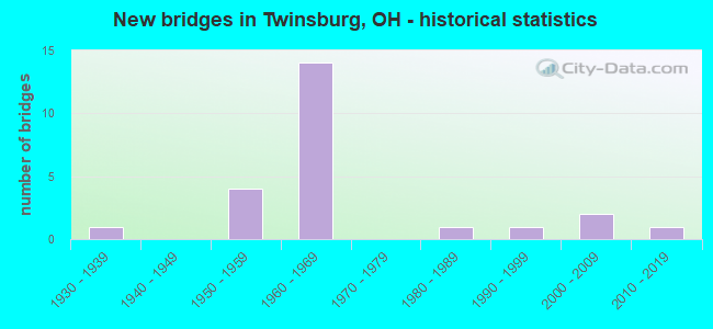
- New bridges - historical statistics
- 11930-1939
- 41950-1959
- 141960-1969
- 11980-1989
- 11990-1999
- 22000-2009
- 12010-2019

- Reconstructed bridges - Historical Statistics
- 11980-1989
- 11990-1999
- 32000-2009


- Bridge Condition - Deck
- 6.3%Very good
- 50.0%Good
- 31.3%Satisfactory
- 6.3%Fair
- 6.3%Serious

- Bridge Condition - Superstructure
- 25.0%Very good
- 37.5%Good
- 31.3%Satisfactory
- 6.3%Fair

- Bridge Condition - Substructure
- 18.8%Very good
- 50.0%Good
- 18.8%Satisfactory
- 12.5%Fair

- Bridge Condition - Channel
- 14.3%Very good
- 14.3%Good
- 71.4%Satisfactory
Find on map >> Show street view
Structure Number: 3430006, Location: 0.2 MI E OF JCT SR 250 (Lat: 40.237719, Lng: -80.960750), Route carried "on" structure: County highway C0015, Year Built: 1930, Year Reconstructed: 2012, Status: Temporarily open, Structure Length: 1.74m (5.71ft), Average Daily Traffic: 501 (year 2015), Truck Traffic: 8%, Average Future Daily Traffic: 695 (year 2035), Design Load: H 20, Features Intersected: MIDDLE FORK OF SHORTCREE, Facility Carried by Structure: COUNTY RD 15
Minimum Vertical Clearance: 30+ m (98+ ft), Kilometerpoint: 7.886, Lanes on structure: 2, Owner: County Highway Agency, Approaching Roadway Width: 9.1m (29.9ft), Skew: 4 degrees, Material/Design: Steel, Design/Construction: Stringer/Multi-beam, Number Of Spans In Main Unit: 1, Length of Maximum Span: 16.8m (55.1ft), Curb-To-Curb Width: 7.1m (23.3ft), Out-to-Out Width: 7.3m (24.0ft)
Condition: Deck: Serious, Superstructure: Satisfactory, Substructure: Fair, Channel: Satisfactory, Structural Evaluation: High priority of replacement, Deck Geometry: Meets minimum limits, Waterway Adequacy: Equal to present desirable criteria, Approach Roadway Alignment: Equal to present desirable criteria, Length Of Structure Improvement: 2.13m (6.99ft), Designated Inspection Frequency: Every 12 months, Inspection Date: November 2021, Roadway Improvement Cost: $15,000, Total Project Cost: $180,000, Deck Structure Type: Wood or Timber, Wearing Surface/Protective System: Wearing Surface: Bituminous
Find on map >> Show street view
Structure Number: 770696, Location: 0.22 MI W OF SR 14 (Lat: 41.311450, Lng: -81.451631), Route carried "on" structure: State highway 82, Year Built: 1968, Year Reconstructed: 2006, Status: Open, Structure Length: 10.06m (33.01ft), Average Daily Traffic: 16,938 (year 2015), Truck Traffic: 6%, Average Future Daily Traffic: 23,510 (year 2035), Design Load: HS 20, Features Intersected: OVER SUM-IR 480-4.12
Minimum Vertical Clearance: 30+ m (98+ ft), Kilometerpoint: 11.619, Lanes on structure: 6, Lanes under structure: 4, Owner: State Highway Agency, Approaching Roadway Width: 27.0m (88.6ft), Material/Design: Steel continuous, Design/Construction: Stringer/Multi-beam, Number Of Spans In Main Unit: 4, Length of Maximum Span: 30.8m (101.0ft), Curb-To-Curb Width: 26.1m (85.6ft), Out-to-Out Width: 27.0m (88.6ft)
Condition: Deck: Good, Superstructure: Good, Substructure: Good, Operating Rating: 42.1 metric tons, Method Used To Determine Operating Rating: Allowable Stress (AS) rating reported by rating factor (RF) method using MS18 loading, Inventory Rating: 32.4 metric tons, Method Used To Determine Inventory Rating: Allowable Stress (AS) rating reported by rating factor (RF) method using MS18 loading, Structural Evaluation: Better than present minimum criteria, Deck Geometry: Equal to present minimum criteria, Underclear: Meets minimum limits, Approach Roadway Alignment: Meets minimum limits, Designated Inspection Frequency: Every 24 months, Inspection Date: June 2021, Deck Structure Type: Concrete Cast-file-Place, Wearing Surface/Protective System: Wearing Surface: Monolithic Concrete, Deck Protection: Epoxy Coated Reinforcing
Find on map >> Show street view
Structure Number: 7707002, Location: 0.20 MI E OF SR 91 (Lat: 41.311419, Lng: -81.437050), Route carried "on" structure: State highway 82, Year Built: 1986, Status: Open, Structure Length: 3.11m (10.20ft), Average Daily Traffic: 7,844 (year 2015), Truck Traffic: 6%, Average Future Daily Traffic: 10,887 (year 2035), Design Load: HS 20+Mod, Features Intersected: TINKERS CREEK
Minimum Vertical Clearance: 30+ m (98+ ft), Kilometerpoint: 12.891, Lanes on structure: 4, Owner: State Highway Agency, Approaching Roadway Width: 21.3m (69.9ft), Material/Design: Steel continuous, Design/Construction: Stringer/Multi-beam, Number Of Spans In Main Unit: 2, Length of Maximum Span: 15.2m (49.9ft), Curb-To-Curb Width: 15.5m (50.9ft), Out-to-Out Width: 16.1m (52.8ft)
Condition: Deck: Good, Superstructure: Very good, Substructure: Good, Channel: Very good, Operating Rating: 51.8 metric tons, Method Used To Determine Operating Rating: Load and Resistance Factor Rating (LRFR) rating reported by rating factor(RF) method using HL-93 loadings, Inventory Rating: 38.9 metric tons, Method Used To Determine Inventory Rating: Load and Resistance Factor Rating (LRFR) rating reported by rating factor(RF) method using HL-93 loadings, Structural Evaluation: Better than present minimum criteria, Deck Geometry: Meets minimum limits, Waterway Adequacy: Equal to present desirable criteria, Approach Roadway Alignment: Equal to present desirable criteria, Designated Inspection Frequency: Every 24 months, Inspection Date: June 2021, Deck Structure Type: Concrete Cast-file-Place, Wearing Surface/Protective System: Wearing Surface: Integral Concrete, Deck Protection: Epoxy Coated Reinforcing
Find on map >> Show street view
Structure Number: 7707037, Location: 2.29 MI E OF SR 91 (Lat: 41.305089, Lng: -81.399789), Route carried "on" structure: State highway 82, Year Built: 2011, Status: Open, Structure Length: 2.20m (7.22ft), Average Daily Traffic: 7,844 (year 2015), Truck Traffic: 6%, Average Future Daily Traffic: 10,887 (year 2035), Design Load: HL 93, Features Intersected: POND BROOK
Minimum Vertical Clearance: 30+ m (98+ ft), Kilometerpoint: 16.335, Lanes on structure: 2, Owner: State Highway Agency, Approaching Roadway Width: 7.3m (24.0ft), Material/Design: Prestressed concrete, Design/Construction: Box Beam or Girders - Multiple, Number Of Spans In Main Unit: 1, Length of Maximum Span: 21.3m (69.9ft), Curb-To-Curb Width: 13.4m (44.0ft), Out-to-Out Width: 13.4m (44.0ft)
Condition: Deck: Very good, Superstructure: Very good, Substructure: Very good, Channel: Satisfactory, Operating Rating: 77.8 metric tons, Method Used To Determine Operating Rating: Load Factor (LF) rating reported by rating factor (RF) method using MS18 loading, Inventory Rating: 55.1 metric tons, Method Used To Determine Inventory Rating: Load Factor (LF) rating reported by rating factor (RF) method using MS18 loading, Structural Evaluation: Equal to present desirable criteria, Deck Geometry: Equal to present minimum criteria, Waterway Adequacy: Superior to present desirable criteria, Approach Roadway Alignment: Equal to present desirable criteria, Designated Inspection Frequency: Every 24 months, Inspection Date: June 2021, Deck Structure Type: Concrete Cast-file-Place, Wearing Surface/Protective System: Wearing Surface: Monolithic Concrete, Deck Protection: Epoxy Coated Reinforcing
Find on map >> Show street view
Structure Number: 7707444, Location: 0.40 MI S OF SR 82 (Lat: 41.318311, Lng: -81.440169), Route carried "on" structure: State highway 91, Year Built: 1955, Year Reconstructed: 2003, Status: Open, Structure Length: 3.63m (11.91ft), Average Daily Traffic: 11,755 (year 2015), Truck Traffic: 7%, Average Future Daily Traffic: 16,316 (year 2035), Design Load: H 20, Features Intersected: TINKERS CREEK
Minimum Vertical Clearance: 30+ m (98+ ft), Kilometerpoint: 32.316, Lanes on structure: 2, Base Highway Network: Yes, Owner: State Highway Agency, Approaching Roadway Width: 7.3m (24.0ft), Material/Design: Concrete continuous, Design/Construction: Slab, Number Of Spans In Main Unit: 3, Length of Maximum Span: 12.8m (42.0ft), Curb-To-Curb Width: 12.2m (40.0ft), Out-to-Out Width: 12.2m (40.0ft)
Condition: Deck: Fair, Superstructure: Fair, Substructure: Good, Channel: Good, Operating Rating: 42.1 metric tons, Method Used To Determine Operating Rating: Allowable Stress (AS) rating reported by rating factor (RF) method using MS18 loading, Inventory Rating: 32.4 metric tons, Method Used To Determine Inventory Rating: Allowable Stress (AS) rating reported by rating factor (RF) method using MS18 loading, Structural Evaluation: Somewhat better than minimum adequacy, Deck Geometry: Somewhat better than minimum adequacy, Waterway Adequacy: Equal to present minimum criteria, Approach Roadway Alignment: Equal to present minimum criteria, Designated Inspection Frequency: Every 12 months, Inspection Date: July 2021, Deck Structure Type: Concrete Cast-file-Place, Wearing Surface/Protective System: Wearing Surface: Bituminous
Find on map >> Show street view
Structure Number: 7710208, Location: 2.69 MI N OF SR 82 (Lat: 41.338500, Lng: -81.489111), Route carried "on" structure: County highway C7026, Year Built: 1965, Status: Open, Structure Length: 9.91m (32.51ft), Average Daily Traffic: 4,823 (year 2015), Truck Traffic: 5%, Average Future Daily Traffic: 60,783 (year 2035), Design Load: HS 15, Features Intersected: IR480, Facility Carried by Structure: SHEPARD ROAD
Minimum Vertical Clearance: 30+ m (98+ ft), Kilometerpoint: 4.410, Lanes on structure: 2, Lanes under structure: 4, Owner: State Highway Agency, Approaching Roadway Width: 5.5m (18.0ft), Skew: 3 degrees, Material/Design: Steel continuous, Design/Construction: Stringer/Multi-beam, Number Of Spans In Main Unit: 4, Length of Maximum Span: 36.6m (120.1ft), Curb or Sidewalk Widths: Left: 0.7m (2.3ft), Right: 0.7m (2.3ft), Curb-To-Curb Width: 7.3m (24.0ft), Out-to-Out Width: 9.1m (29.9ft)
Condition: Deck: Good, Superstructure: Satisfactory, Substructure: Good, Operating Rating: 22.7 metric tons, Method Used To Determine Operating Rating: Load Factor (LF) rating reported by rating factor (RF) method using MS18 loading, Inventory Rating: 16.2 metric tons, Method Used To Determine Inventory Rating: Load Factor (LF) rating reported by rating factor (RF) method using MS18 loading, Structural Evaluation: Meets minimum limits, Deck Geometry: High priority of replacement, Underclear: High priority of corrective action, Approach Roadway Alignment: Equal to present desirable criteria, Designated Inspection Frequency: Every 12 months, Inspection Date: August 2021, Deck Structure Type: Concrete Cast-file-Place, Wearing Surface/Protective System: Wearing Surface: Bituminous
Find on map >> Show street view
Structure Number: 7710232, Location: 2.01 MI N OF SR 82 (Lat: 41.332111, Lng: -81.479400), Route carried "on" structure: Interstate 480, Year Built: 1965, Status: Open, Structure Length: 6.58m (21.59ft), Average Daily Traffic: 21,896 (year 2015), Truck Traffic: 9%, Average Future Daily Traffic: 30,392 (year 2035), Design Load: HS 20, Features Intersected: OVER CHAMBERLAIN RD CR12
Minimum Vertical Clearance: 30+ m (98+ ft), Kilometerpoint: 3.347, Lanes on structure: 2, Lanes under structure: 2, Base Highway Network: Yes, Owner: State Highway Agency, Approaching Roadway Width: 12.2m (40.0ft), Skew: 5 degrees, Material/Design: Steel continuous, Design/Construction: Stringer/Multi-beam, Number Of Spans In Main Unit: 3, Length of Maximum Span: 31.7m (104.0ft), Curb-To-Curb Width: 12.5m (41.0ft), Out-to-Out Width: 13.4m (44.0ft)
Condition: Deck: Good, Superstructure: Good, Substructure: Satisfactory, Operating Rating: 51.8 metric tons, Method Used To Determine Operating Rating: Load and Resistance Factor Rating (LRFR) rating reported by rating factor(RF) method using HL-93 loadings, Inventory Rating: 38.9 metric tons, Method Used To Determine Inventory Rating: Load and Resistance Factor Rating (LRFR) rating reported by rating factor(RF) method using HL-93 loadings, Structural Evaluation: Equal to present minimum criteria, Deck Geometry: Better than present minimum criteria, Underclear: Somewhat better than minimum adequacy, Approach Roadway Alignment: Equal to present desirable criteria, Designated Inspection Frequency: Every 12 months, Inspection Date: August 2021, Deck Structure Type: Concrete Cast-file-Place, Wearing Surface/Protective System: Wearing Surface: Bituminous
Find on map >> Show street view
Structure Number: 7710267, Location: 2.01 MI N OF SR 82 (Lat: 41.331539, Lng: -81.479561), Route carried "on" structure: Interstate 480, Year Built: 1965, Status: Open, Structure Length: 6.58m (21.59ft), Average Daily Traffic: 21,896 (year 2015), Truck Traffic: 9%, Average Future Daily Traffic: 30,392 (year 2035), Design Load: HS 20, Features Intersected: OVER CHAMBERLAIN RD CR12
Minimum Vertical Clearance: 30+ m (98+ ft), Kilometerpoint: 3.347, Lanes on structure: 2, Lanes under structure: 2, Base Highway Network: Yes, Owner: State Highway Agency, Approaching Roadway Width: 12.2m (40.0ft), Skew: 5 degrees, Material/Design: Steel continuous, Design/Construction: Stringer/Multi-beam, Number Of Spans In Main Unit: 3, Length of Maximum Span: 31.7m (104.0ft), Curb-To-Curb Width: 12.5m (41.0ft), Out-to-Out Width: 13.4m (44.0ft)
Condition: Deck: Good, Superstructure: Good, Substructure: Good, Operating Rating: 51.8 metric tons, Method Used To Determine Operating Rating: Load and Resistance Factor Rating (LRFR) rating reported by rating factor(RF) method using HL-93 loadings, Inventory Rating: 38.9 metric tons, Method Used To Determine Inventory Rating: Load and Resistance Factor Rating (LRFR) rating reported by rating factor(RF) method using HL-93 loadings, Structural Evaluation: Better than present minimum criteria, Deck Geometry: Better than present minimum criteria, Underclear: Somewhat better than minimum adequacy, Approach Roadway Alignment: Equal to present desirable criteria, Designated Inspection Frequency: Every 24 months, Inspection Date: August 2021, Deck Structure Type: Concrete Cast-file-Place, Wearing Surface/Protective System: Wearing Surface: Bituminous
Find on map >> Show street view
Structure Number: 7710356, Location: JCT OF IR 480 AND SR 91 (Lat: 41.306181, Lng: -81.440500), Route carried "on" structure: Interstate 480, Year Built: 1965, Status: Open, Structure Length: 6.74m (22.11ft), Average Daily Traffic: 18,513 (year 2015), Truck Traffic: 12%, Average Future Daily Traffic: 25,696 (year 2035), Design Load: HS 20, Features Intersected: OVER SUM-SR 91-19.20
Minimum Vertical Clearance: 30+ m (98+ ft), Kilometerpoint: 7.725, Lanes on structure: 2, Lanes under structure: 6, Base Highway Network: Yes, Owner: State Highway Agency, Approaching Roadway Width: 7.3m (24.0ft), Skew: 2 degrees, Material/Design: Steel continuous, Design/Construction: Stringer/Multi-beam, Number Of Spans In Main Unit: 4, Length of Maximum Span: 21.3m (69.9ft), Curb-To-Curb Width: 12.5m (41.0ft), Out-to-Out Width: 14.0m (45.9ft)
Condition: Deck: Satisfactory, Superstructure: Good, Substructure: Good, Operating Rating: 48.6 metric tons, Method Used To Determine Operating Rating: Load and Resistance Factor Rating (LRFR) rating reported by rating factor(RF) method using HL-93 loadings, Inventory Rating: 38.9 metric tons, Method Used To Determine Inventory Rating: Load and Resistance Factor Rating (LRFR) rating reported by rating factor(RF) method using HL-93 loadings, Structural Evaluation: Better than present minimum criteria, Deck Geometry: Better than present minimum criteria, Underclear: Somewhat better than minimum adequacy, Approach Roadway Alignment: Equal to present desirable criteria, Designated Inspection Frequency: Every 12 months, Inspection Date: August 2021, Deck Structure Type: Concrete Cast-file-Place, Wearing Surface/Protective System: Wearing Surface: Integral Concrete
Find on map >> Show street view
Structure Number: 771038, Location: JCT OF IR 480 AND SR 91 (Lat: 41.305769, Lng: -81.440581), Route carried "on" structure: Interstate 480, Year Built: 1965, Status: Open, Structure Length: 6.74m (22.11ft), Average Daily Traffic: 18,513 (year 2015), Truck Traffic: 12%, Average Future Daily Traffic: 25,696 (year 2035), Design Load: HS 20, Features Intersected: OVER SUM-SR 91-19.18
Minimum Vertical Clearance: 30+ m (98+ ft), Kilometerpoint: 7.725, Lanes on structure: 2, Lanes under structure: 6, Base Highway Network: Yes, Owner: State Highway Agency, Approaching Roadway Width: 7.3m (24.0ft), Skew: 2 degrees, Material/Design: Steel continuous, Design/Construction: Stringer/Multi-beam, Number Of Spans In Main Unit: 4, Length of Maximum Span: 21.3m (69.9ft), Curb-To-Curb Width: 12.5m (41.0ft), Out-to-Out Width: 13.4m (44.0ft)
Condition: Deck: Satisfactory, Superstructure: Good, Substructure: Good, Operating Rating: 48.6 metric tons, Method Used To Determine Operating Rating: Load and Resistance Factor Rating (LRFR) rating reported by rating factor(RF) method using HL-93 loadings, Inventory Rating: 38.9 metric tons, Method Used To Determine Inventory Rating: Load and Resistance Factor Rating (LRFR) rating reported by rating factor(RF) method using HL-93 loadings, Structural Evaluation: Better than present minimum criteria, Deck Geometry: Better than present minimum criteria, Underclear: Somewhat better than minimum adequacy, Approach Roadway Alignment: Equal to present desirable criteria, Designated Inspection Frequency: Every 12 months, Inspection Date: August 2021, Deck Structure Type: Concrete Cast-file-Place, Wearing Surface/Protective System: Wearing Surface: Integral Concrete
Find on map >> Show street view
Structure Number: 771041, Location: 1.91 MI E OF SR 91 (Lat: 41.284669, Lng: -81.419019), Route carried "on" structure: County highway C0109, Year Built: 1965, Year Reconstructed: 2007, Status: Open, Structure Length: 8.93m (29.30ft), Average Daily Traffic: 4,063 (year 2015), Truck Traffic: 5%, Average Future Daily Traffic: 51,148 (year 2035), Design Load: H 15, Features Intersected: I-480, Facility Carried by Structure: OLD MILL RD CR-10
Minimum Vertical Clearance: 30+ m (98+ ft), Kilometerpoint: 1.770, Lanes on structure: 2, Lanes under structure: 4, Owner: State Highway Agency, Approaching Roadway Width: 6.1m (20.0ft), Skew: 2 degrees, Material/Design: Steel continuous, Design/Construction: Stringer/Multi-beam, Number Of Spans In Main Unit: 4, Length of Maximum Span: 24.4m (80.1ft), Curb-To-Curb Width: 7.3m (24.0ft), Out-to-Out Width: 9.2m (30.2ft)
Condition: Deck: Good, Superstructure: Good, Substructure: Good, Operating Rating: 22.7 metric tons, Method Used To Determine Operating Rating: Load Factor (LF) rating reported by rating factor (RF) method using MS18 loading, Inventory Rating: 16.2 metric tons, Method Used To Determine Inventory Rating: Load Factor (LF) rating reported by rating factor (RF) method using MS18 loading, Structural Evaluation: Meets minimum limits, Deck Geometry: High priority of replacement, Underclear: High priority of corrective action, Approach Roadway Alignment: Equal to present desirable criteria, Designated Inspection Frequency: Every 24 months, Inspection Date: August 2021, Deck Structure Type: Concrete Cast-file-Place, Wearing Surface/Protective System: Wearing Surface: Monolithic Concrete, Deck Protection: Epoxy Coated Reinforcing
Find on map >> Show street view
Structure Number: 7755058, Location: 4000 FT N OF SR 91 (Lat: 41.340600, Lng: -81.454789), Route carried "on" structure: County highway C0126, Year Built: 1959, Year Reconstructed: 1988, Status: Open, Structure Length: 3.60m (11.81ft), Average Daily Traffic: 7,527 (year 2018), Truck Traffic: 5%, Average Future Daily Traffic: 10,447 (year 2038), Design Load: HS 20+Mod, Features Intersected: TINKERS CREEK, Facility Carried by Structure: GLENWOOD DR
Minimum Vertical Clearance: 30+ m (98+ ft), Kilometerpoint: 1.835, Lanes on structure: 2, Owner: County Highway Agency, Approaching Roadway Width: 8.2m (26.9ft), Material/Design: Prestressed concrete, Design/Construction: Box Beam or Girders - Multiple, Number Of Spans In Main Unit: 3, Length of Maximum Span: 13.1m (43.0ft), Curb or Sidewalk Widths: Left: 0.0m, Right: 1.8m (5.9ft), Curb-To-Curb Width: 9.8m (32.2ft), Out-to-Out Width: 9.8m (32.2ft)
Condition: Deck: Satisfactory, Superstructure: Satisfactory, Substructure: Fair, Channel: Satisfactory, Operating Rating: 58.3 metric tons, Method Used To Determine Operating Rating: Load Factor (LF) rating reported by rating factor (RF) method using MS18 loading, Inventory Rating: 35.6 metric tons, Method Used To Determine Inventory Rating: Load Factor (LF) rating reported by rating factor (RF) method using MS18 loading, Structural Evaluation: Somewhat better than minimum adequacy, Deck Geometry: Meets minimum limits, Waterway Adequacy: Better than present minimum criteria, Approach Roadway Alignment: Equal to present minimum criteria, Designated Inspection Frequency: Every 12 months, Inspection Date: March 2021, Deck Structure Type: Other, Wearing Surface/Protective System: Wearing Surface: Bituminous, Membrane: Built-up
Find on map >> Show street view
Structure Number: 7755082, Location: 2600 FT S OF GLENWOOD RD (Lat: 41.333869, Lng: -81.469311), Route carried "on" structure: County highway C0012, Year Built: 1998, Status: Open, Structure Length: 0.79m (2.59ft), Average Daily Traffic: 9,695 (year 2015), Truck Traffic: 7%, Average Future Daily Traffic: 13,457 (year 2035), Design Load: HS 20+Mod, Features Intersected: BRANCH OF TINKERS CREEK, Facility Carried by Structure: RAVENNA RD.
Minimum Vertical Clearance: 30+ m (98+ ft), Kilometerpoint: 10.058, Lanes on structure: 2, Owner: County Highway Agency, Approaching Roadway Width: 10.4m (34.1ft), Material/Design: Concrete, Design/Construction: Culvert, Number Of Spans In Main Unit: 1, Length of Maximum Span: 7.9m (25.9ft)
Condition: Channel: Satisfactory, Culverts: Good, Operating Rating: 61.6 metric tons, Method Used To Determine Operating Rating: Load Factor (LF) rating reported by rating factor (RF) method using MS18 loading, Inventory Rating: 38.9 metric tons, Method Used To Determine Inventory Rating: Load Factor (LF) rating reported by rating factor (RF) method using MS18 loading, Structural Evaluation: Better than present minimum criteria, Waterway Adequacy: Better than present minimum criteria, Approach Roadway Alignment: Equal to present desirable criteria, Designated Inspection Frequency: Every 24 months, Inspection Date: June 2021
Find on map >> Show street view
Structure Number: 775509, Location: 400 FT NE OF RAVENNA RD (Lat: 41.320039, Lng: -81.448381), Route carried "on" structure: City street CVP, Year Built: 2004, Status: Open, Structure Length: 10.88m (35.70ft), Average Daily Traffic: 10,000 (year 1999), Truck Traffic: 5%, Average Future Daily Traffic: 13,880 (year 2019), Design Load: HS 20+Mod, Features Intersected: TINKERS CREEK, Facility Carried by Structure: MIKTARIAN PARKWAY
Minimum Vertical Clearance: 30+ m (98+ ft), Kilometerpoint: 0.595, Lanes on structure: 2, Owner: County Highway Agency, Approaching Roadway Width: 11.6m (38.1ft), Skew: 1 degrees, Material/Design: Prestressed concrete continuous, Design/Construction: Box Beam or Girders - Multiple, Number Of Spans In Main Unit: 7, Length of Maximum Span: 15.5m (50.9ft), Curb or Sidewalk Widths: Left: 1.5m (4.9ft), Right: 1.5m (4.9ft), Curb-To-Curb Width: 11.6m (38.1ft), Out-to-Out Width: 12.3m (40.4ft)
Condition: Deck: Good, Superstructure: Very good, Substructure: Very good, Channel: Satisfactory, Operating Rating: 64.8 metric tons, Method Used To Determine Operating Rating: Load Factor (LF) rating reported by rating factor (RF) method using MS18 loading, Inventory Rating: 38.9 metric tons, Method Used To Determine Inventory Rating: Load Factor (LF) rating reported by rating factor (RF) method using MS18 loading, Structural Evaluation: Equal to present desirable criteria, Deck Geometry: Somewhat better than minimum adequacy, Waterway Adequacy: Superior to present desirable criteria, Approach Roadway Alignment: Equal to present desirable criteria, Designated Inspection Frequency: Every 24 months, Inspection Date: January 2021, Deck Structure Type: Concrete Cast-file-Place, Wearing Surface/Protective System: Wearing Surface: Monolithic Concrete, Deck Protection: Epoxy Coated Reinforcing
Find on map >> Show street view
Structure Number: 7755104, Location: 750 FT W OF SR 91 (Lat: 41.325000, Lng: -81.442800), Route carried "on" structure: City street CVP, Year Built: 2004, Status: Open, Structure Length: 5.03m (16.50ft), Average Daily Traffic: 10,000 (year 1999), Truck Traffic: 5%, Average Future Daily Traffic: 13,880 (year 2019), Design Load: HS 20+Mod, Features Intersected: W & LE RAILROAD, Facility Carried by Structure: MIKTARIAN PARKWAY
Minimum Vertical Clearance: 30+ m (98+ ft), Kilometerpoint: 1.304, Lanes on structure: 2, Owner: City or Municipal Highway Agency, Approaching Roadway Width: 8.5m (27.9ft), Material/Design: Steel continuous, Design/Construction: Stringer/Multi-beam, Number Of Spans In Main Unit: 3, Length of Maximum Span: 19.8m (65.0ft), Curb or Sidewalk Widths: Left: 1.5m (4.9ft), Right: 1.5m (4.9ft), Curb-To-Curb Width: 8.5m (27.9ft), Out-to-Out Width: 12.3m (40.4ft)
Condition: Deck: Good, Superstructure: Very good, Substructure: Very good, Operating Rating: 58.3 metric tons, Method Used To Determine Operating Rating: Load Factor (LF) rating reported by rating factor (RF) method using MS18 loading, Inventory Rating: 35.6 metric tons, Method Used To Determine Inventory Rating: Load Factor (LF) rating reported by rating factor (RF) method using MS18 loading, Structural Evaluation: Equal to present desirable criteria, Deck Geometry: High priority of replacement, Underclear: Superior to present desirable criteria, Approach Roadway Alignment: Equal to present desirable criteria, Designated Inspection Frequency: Every 24 months, Inspection Date: September 2021, Deck Structure Type: Concrete Cast-file-Place, Wearing Surface/Protective System: Wearing Surface: Monolithic Concrete, Deck Protection: Epoxy Coated Reinforcing
Find on map >> Show street view
Structure Number: 7756003, Location: 2800 FT N OF HIGHLANDER (Lat: 41.305000, Lng: -81.471669), Route carried "on" structure: County highway T0128, Year Built: 1956, Status: Open, Structure Length: 3.60m (11.81ft), Average Daily Traffic: 5,700 (year 2015), Truck Traffic: 5%, Average Future Daily Traffic: 7,912 (year 2035), Design Load: H 15, Features Intersected: NORFOLK SOUTHERN, Facility Carried by Structure: CHAMBERLAIN RD
Minimum Vertical Clearance: 30+ m (98+ ft), Kilometerpoint: 0.515, Lanes on structure: 2, Owner: County Highway Agency, Approaching Roadway Width: 9.8m (32.2ft), Material/Design: Concrete continuous, Design/Construction: Slab, Number Of Spans In Main Unit: 3, Length of Maximum Span: 13.7m (44.9ft), Curb or Sidewalk Widths: Left: 0.4m (1.3ft), Right: 0.4m (1.3ft), Curb-To-Curb Width: 11.2m (36.7ft), Out-to-Out Width: 11.6m (38.1ft)
Condition: Deck: Satisfactory, Superstructure: Satisfactory, Substructure: Satisfactory, Operating Rating: 48.6 metric tons, Method Used To Determine Operating Rating: Load Factor (LF) rating reported by rating factor (RF) method using MS18 loading, Inventory Rating: 29.2 metric tons, Method Used To Determine Inventory Rating: Load Factor (LF) rating reported by rating factor (RF) method using MS18 loading, Structural Evaluation: Equal to present minimum criteria, Deck Geometry: Meets minimum limits, Underclear: Meets minimum limits, Approach Roadway Alignment: Equal to present desirable criteria, Designated Inspection Frequency: Every 12 months, Inspection Date: January 2021, Deck Structure Type: Concrete Cast-file-Place, Wearing Surface/Protective System: Wearing Surface: Bituminous
Find on map >> Show street view
Structure Number: 7756011, Location: 2800 FT N OF HIGHLANDER (Lat: 41.302219, Lng: -81.472181), Route carried "on" structure: County highway T0128, Year Built: 1956, Status: Open, Structure Length: 3.60m (11.81ft), Average Daily Traffic: 5,700 (year 2015), Truck Traffic: 5%, Average Future Daily Traffic: 7,912 (year 2035), Design Load: H 15, Features Intersected: NORFOLK SOUTHERN, Facility Carried by Structure: CHAMBERLAIN RD
Minimum Vertical Clearance: 30+ m (98+ ft), Kilometerpoint: 0.515, Lanes on structure: 2, Owner: County Highway Agency, Approaching Roadway Width: 9.8m (32.2ft), Material/Design: Concrete continuous, Design/Construction: Slab, Number Of Spans In Main Unit: 3, Length of Maximum Span: 13.7m (44.9ft), Curb or Sidewalk Widths: Left: 0.4m (1.3ft), Right: 0.4m (1.3ft), Curb-To-Curb Width: 11.2m (36.7ft), Out-to-Out Width: 11.6m (38.1ft)
Condition: Deck: Satisfactory, Superstructure: Satisfactory, Substructure: Satisfactory, Operating Rating: 48.6 metric tons, Method Used To Determine Operating Rating: Load Factor (LF) rating reported by rating factor (RF) method using MS18 loading, Inventory Rating: 29.2 metric tons, Method Used To Determine Inventory Rating: Load Factor (LF) rating reported by rating factor (RF) method using MS18 loading, Structural Evaluation: Equal to present minimum criteria, Deck Geometry: Meets minimum limits, Underclear: Meets minimum limits, Approach Roadway Alignment: Equal to present desirable criteria, Designated Inspection Frequency: Every 12 months, Inspection Date: January 2021, Deck Structure Type: Concrete Cast-file-Place, Wearing Surface/Protective System: Wearing Surface: Bituminous
Find on map >> Show street view
Structure Number: 770696, Location: 0.22 MI W OF SR 14 (Lat: 41.311450, Lng: -81.451631), Route carried "under" structure: Interstate 480, Year Built: 1968, Structure Length: 0. m, Average Daily Traffic: 40,497 (year 2015), Truck Traffic: 10%, Features Intersected: SR 82, Facility Carried by Structure: SR 82
Minimum Vertical Clearance: 5.56m (18.24ft), Kilometerpoint: 6.630, Lanes on structure: 6, Lanes under structure: 4, Material/Design: Steel continuous, Design/Construction: Stringer/Multi-beam, Length of Maximum Span: 30.8m (101.0ft)
Find on map >> Show street view
Structure Number: 7710208, Location: 2.69 MI N OF SR 82 (Lat: 41.338500, Lng: -81.489111), Route carried "under" structure: Interstate 480, Year Built: 1965, Structure Length: 0. m, Average Daily Traffic: 43,792 (year 2015), Truck Traffic: 9%, Features Intersected: UNDER SHEPARD RD CR-7026, Facility Carried by Structure: SHEPARD ROAD
Minimum Vertical Clearance: 4.90m (16.08ft), Kilometerpoint: 2.205, Lanes on structure: 2, Lanes under structure: 4, Material/Design: Steel continuous, Design/Construction: Stringer/Multi-beam, Length of Maximum Span: 36.6m (120.1ft)
Find on map >> Show street view
Structure Number: 7710232, Location: 2.01 MI N OF SR 82 (Lat: 41.332111, Lng: -81.479400), Route carried "under" structure: County highway 128, Year Built: 1965, Structure Length: 0. m, Average Daily Traffic: 4,907 (year 2015), Truck Traffic: 5%, Features Intersected: IR480, Facility Carried by Structure: I.R. 480
Minimum Vertical Clearance: 4.88m (16.01ft), Kilometerpoint: 3.943, Lanes on structure: 2, Lanes under structure: 2, Material/Design: Steel continuous, Design/Construction: Stringer/Multi-beam, Length of Maximum Span: 31.7m (104.0ft)
Find on map >> Show street view
Structure Number: 7710267, Location: 2.01 MI N OF SR 82 (Lat: 41.331539, Lng: -81.479561), Route carried "under" structure: County highway 128, Year Built: 1965, Structure Length: 0. m, Average Daily Traffic: 4,907 (year 2015), Truck Traffic: 5%, Features Intersected: IR480, Facility Carried by Structure: I.R. 480
Minimum Vertical Clearance: 4.88m (16.01ft), Kilometerpoint: 3.879, Lanes on structure: 2, Lanes under structure: 2, Material/Design: Steel continuous, Design/Construction: Stringer/Multi-beam, Length of Maximum Span: 31.7m (104.0ft)
Find on map >> Show street view
Structure Number: 7710356, Location: JCT OF IR 480 AND SR 91 (Lat: 41.306181, Lng: -81.440500), Route carried "under" structure: State highway 91, Year Built: 1965, Structure Length: 0. m, Average Daily Traffic: 27,686 (year 2015), Truck Traffic: 7%, Features Intersected: I-480, Facility Carried by Structure: I.R. 480
Minimum Vertical Clearance: 6.48m (21.26ft), Kilometerpoint: 30.899, Lanes on structure: 2, Lanes under structure: 6, Material/Design: Steel continuous, Design/Construction: Stringer/Multi-beam, Length of Maximum Span: 21.3m (69.9ft)
Find on map >> Show street view
Structure Number: 771038, Location: JCT OF IR 480 AND SR 91 (Lat: 41.305769, Lng: -81.440581), Route carried "under" structure: State highway 91, Year Built: 1965, Structure Length: 0. m, Average Daily Traffic: 27,686 (year 2015), Truck Traffic: 7%, Features Intersected: I-480, Facility Carried by Structure: I.R. 480
Minimum Vertical Clearance: 4.95m (16.24ft), Kilometerpoint: 30.867, Lanes on structure: 2, Lanes under structure: 6, Material/Design: Steel continuous, Design/Construction: Stringer/Multi-beam, Length of Maximum Span: 21.3m (69.9ft)
Find on map >> Show street view
Structure Number: 771041, Location: 1.91 MI E OF SR 91 (Lat: 41.284669, Lng: -81.419019), Route carried "under" structure: Interstate 480, Year Built: 1965, Structure Length: 0. m, Average Daily Traffic: 36,850 (year 2015), Truck Traffic: 12%, Features Intersected: UNDER OLD MILL RD CR-109, Facility Carried by Structure: OLD MILL RD CR-10
Minimum Vertical Clearance: 5.08m (16.67ft), Kilometerpoint: 10.847, Lanes on structure: 2, Lanes under structure: 4, Material/Design: Steel continuous, Design/Construction: Stringer/Multi-beam, Length of Maximum Span: 24.4m (80.1ft)