Bridge Statistics for Tye, Texas (TX)
Condition, Traffic, Stress, Structural Evaluation, Project Costs
- National Bridge Inventory (NBI) Statistics
- 21Number of bridges
- 157ft / 47.8mTotal length
- $183,000Total costs
- 191,213Total average daily traffic
- 59,522Total average daily truck traffic
- National Bridge Inventory (NBI) Registered Bridges for Tye
- No street view available for this location
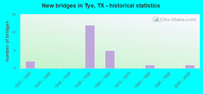
- New bridges - historical statistics
- 21920-1929
- 121950-1959
- 51960-1969
- 11980-1989
- 12000-2009

- Reconstructed bridges - Historical Statistics
- 21940-1949
- 01950-1959
- 11960-1969
- 11970-1979
- 01980-1989
- 11990-1999
- 12000-2009


- Bridge Condition - Deck
- 10.0%Very good
- 40.0%Good
- 50.0%Satisfactory

- Bridge Condition - Superstructure
- 10.0%Very good
- 40.0%Good
- 50.0%Satisfactory

- Bridge Condition - Substructure
- 40.0%Good
- 50.0%Satisfactory
- 10.0%Fair

- Bridge Condition - Channel
- 11.1%Very good
- 77.8%Good
- 11.1%Satisfactory

- Bridge Condition - Culverts
- 20.0%Good
- 80.0%Satisfactory
Find on map >> Show street view
Structure Number: 82210000605025, Location: 2.30 MI W OF FM 707 (Lat: 32.458633, Lng: -99.911861), Route carried "on" structure: ServiceInterstate 20, Year Built: 1928, Year Reconstructed: 1948, Status: Open, Structure Length: 2.26m (7.41ft), Average Daily Traffic: 390 (year 2013), Truck Traffic: 29%, Average Future Daily Traffic: 550 (year 2033), Design Load: H 15, Features Intersected: BULL WAGON CREEK
Minimum Vertical Clearance: 30+ m (98+ ft), Kilometerpoint: 3.006, Lanes on structure: 2, Owner: State Highway Agency, Approaching Roadway Width: 7.3m (24.0ft), Material/Design: Concrete, Design/Construction: Tee Beam, Number Of Spans In Main Unit: 2, Length of Maximum Span: 11.3m (37.1ft), Curb-To-Curb Width: 13.6m (44.6ft), Out-to-Out Width: 14.1m (46.3ft)
Condition: Deck: Satisfactory, Superstructure: Satisfactory, Substructure: Satisfactory, Channel: Good, Operating Rating: 46.3 metric tons, Method Used To Determine Operating Rating: Load Factor (LF), Inventory Rating: 27.2 metric tons, Method Used To Determine Inventory Rating: Load Factor (LF), Structural Evaluation: Equal to present minimum criteria, Deck Geometry: Superior to present desirable criteria, Waterway Adequacy: Equal to present minimum criteria, Approach Roadway Alignment: Equal to present desirable criteria, Designated Inspection Frequency: Every 24 months, Inspection Date: April 2021, Deck Structure Type: Concrete Cast-file-Place, Wearing Surface/Protective System: Wearing Surface: Bituminous
Find on map >> Show street view
Structure Number: 82210000605086, Location: 2.30 MI W OF FM 707 (Lat: 32.458950, Lng: -99.911853), Route carried "on" structure: Interstate 20, Year Built: 1957, Year Reconstructed: 1977, Status: Open, Structure Length: 1.92m (6.30ft), Average Daily Traffic: 28,925 (year 2020), Truck Traffic: 29%, Average Future Daily Traffic: 35,570 (year 2033), Features Intersected: Bull Wagon Creek
Minimum Vertical Clearance: 30+ m (98+ ft), Kilometerpoint: 3.006, Lanes on structure: 4, Owner: State Highway Agency, Approaching Roadway Width: 23.2m (76.1ft), Material/Design: Concrete, Design/Construction: Culvert, Number Of Spans In Main Unit: 6, Length of Maximum Span: 3.0m (9.8ft), Curb-To-Curb Width: 23.2m (76.1ft), Out-to-Out Width: 45.0m (147.6ft)
Condition: Channel: Good, Culverts: Satisfactory, Operating Rating: 39.9 metric tons, Method Used To Determine Operating Rating: Load Factor (LF), Inventory Rating: 23.6 metric tons, Method Used To Determine Inventory Rating: Load Factor (LF), Structural Evaluation: Somewhat better than minimum adequacy, Deck Geometry: Superior to present desirable criteria, Waterway Adequacy: Equal to present minimum criteria, Approach Roadway Alignment: Equal to present desirable criteria, Designated Inspection Frequency: Every 24 months, Inspection Date: April 2021, Deck Structure Type: Concrete Cast-file-Place, Wearing Surface/Protective System: Wearing Surface: Bituminous
Find on map >> Show street view
Structure Number: 82210000605087, Location: 0.35 MI W OF FM 707 (Lat: 32.459192, Lng: -99.878286), Route carried "on" structure: Interstate 20, Year Built: 1957, Year Reconstructed: 2000, Status: Open, Structure Length: 1.01m (3.31ft), Average Daily Traffic: 28,925 (year 2020), Truck Traffic: 29%, Average Future Daily Traffic: 35,570 (year 2033), Features Intersected: INDIAN CREEK
Minimum Vertical Clearance: 30+ m (98+ ft), Kilometerpoint: 6.177, Lanes on structure: 6, Owner: State Highway Agency, Approaching Roadway Width: 31.1m (102.0ft), Material/Design: Concrete, Design/Construction: Culvert, Number Of Spans In Main Unit: 5, Length of Maximum Span: 1.8m (5.9ft)
Condition: Channel: Good, Culverts: Satisfactory, Operating Rating: 39.9 metric tons, Method Used To Determine Operating Rating: Load Factor (LF), Inventory Rating: 23.6 metric tons, Method Used To Determine Inventory Rating: Load Factor (LF), Structural Evaluation: Somewhat better than minimum adequacy, Waterway Adequacy: Equal to present minimum criteria, Approach Roadway Alignment: Equal to present desirable criteria, Designated Inspection Frequency: Every 24 months, Inspection Date: July 2021
Find on map >> Show street view
Structure Number: 82210000605138, Location: 2.70 MI W OF FM 707 (Lat: 32.459142, Lng: -99.920517), Route carried "on" structure: Interstate 20, Year Built: 1958, Status: Open, Structure Length: 3.47m (11.38ft), Average Daily Traffic: 16,254 (year 2019), Truck Traffic: 29%, Average Future Daily Traffic: 17,780 (year 2033), Design Load: HS 20, Features Intersected: WELLS LN
Minimum Vertical Clearance: 30+ m (98+ ft), Kilometerpoint: 2.185, Lanes on structure: 2, Lanes under structure: 2, Base Highway Network: Yes, Owner: State Highway Agency, Approaching Roadway Width: 11.6m (38.1ft), Material/Design: Concrete continuous, Design/Construction: Slab, Number Of Spans In Main Unit: 3, Length of Maximum Span: 13.7m (44.9ft), Curb-To-Curb Width: 11.3m (37.1ft), Out-to-Out Width: 12.2m (40.0ft)
Condition: Deck: Satisfactory, Superstructure: Satisfactory, Substructure: Satisfactory, Operating Rating: 42.6 metric tons, Method Used To Determine Operating Rating: Load Factor (LF), Inventory Rating: 25.4 metric tons, Method Used To Determine Inventory Rating: Load Factor (LF), Structural Evaluation: Equal to present minimum criteria, Deck Geometry: Somewhat better than minimum adequacy, Underclear: High priority of corrective action, Approach Roadway Alignment: Equal to present desirable criteria, Designated Inspection Frequency: Every 24 months, Inspection Date: April 2021, Deck Structure Type: Concrete Cast-file-Place, Wearing Surface/Protective System: Wearing Surface: Bituminous
Find on map >> Show street view
Structure Number: 82210000605139, Location: 2.70 MI W OF FM 707 (Lat: 32.458964, Lng: -99.920528), Route carried "on" structure: Interstate 20, Year Built: 1958, Status: Open, Structure Length: 3.47m (11.38ft), Average Daily Traffic: 17,696 (year 2019), Truck Traffic: 29%, Average Future Daily Traffic: 17,780 (year 2033), Design Load: HS 20, Features Intersected: WELLS LANE RD
Minimum Vertical Clearance: 30+ m (98+ ft), Kilometerpoint: 2.185, Lanes on structure: 2, Lanes under structure: 2, Base Highway Network: Yes, Owner: State Highway Agency, Approaching Roadway Width: 11.6m (38.1ft), Material/Design: Concrete continuous, Design/Construction: Slab, Number Of Spans In Main Unit: 3, Length of Maximum Span: 13.7m (44.9ft), Curb-To-Curb Width: 11.3m (37.1ft), Out-to-Out Width: 12.2m (40.0ft)
Condition: Deck: Satisfactory, Superstructure: Satisfactory, Substructure: Satisfactory, Operating Rating: 42.6 metric tons, Method Used To Determine Operating Rating: Load Factor (LF), Inventory Rating: 25.4 metric tons, Method Used To Determine Inventory Rating: Load Factor (LF), Structural Evaluation: Equal to present minimum criteria, Deck Geometry: Somewhat better than minimum adequacy, Underclear: High priority of corrective action, Approach Roadway Alignment: Equal to present desirable criteria, Designated Inspection Frequency: Every 24 months, Inspection Date: April 2021, Deck Structure Type: Concrete Cast-file-Place, Wearing Surface/Protective System: Wearing Surface: Bituminous
Find on map >> Show street view
Structure Number: 8221000060514, Location: 2.30 MI W OF FM 707 (Lat: 32.459142, Lng: -99.911883), Route carried "on" structure: ServiceInterstate 20, Year Built: 1958, Status: Open, Structure Length: 1.52m (4.99ft), Average Daily Traffic: 80 (year 2013), Truck Traffic: 29%, Average Future Daily Traffic: 120 (year 2033), Features Intersected: BULL WAGON CREEK
Minimum Vertical Clearance: 30+ m (98+ ft), Kilometerpoint: 3.006, Lanes on structure: 2, Owner: State Highway Agency, Approaching Roadway Width: 6.1m (20.0ft), Material/Design: Concrete, Design/Construction: Slab, Number Of Spans In Main Unit: 2, Length of Maximum Span: 7.6m (24.9ft), Curb-To-Curb Width: 7.8m (25.6ft), Out-to-Out Width: 8.4m (27.6ft)
Condition: Deck: Good, Superstructure: Good, Substructure: Good, Channel: Very good, Operating Rating: 50.8 metric tons, Method Used To Determine Operating Rating: Load Factor (LF), Inventory Rating: 29.9 metric tons, Method Used To Determine Inventory Rating: Load Factor (LF), Structural Evaluation: Better than present minimum criteria, Deck Geometry: Equal to present minimum criteria, Waterway Adequacy: Better than present minimum criteria, Approach Roadway Alignment: Equal to present desirable criteria, Length Of Structure Improvement: 1.52m (4.99ft), Designated Inspection Frequency: Every 24 months, Inspection Date: April 2021, Bridge Improvement Cost: $3,000, Roadway Improvement Cost: $1,000, Total Project Cost: $4,000, Deck Structure Type: Concrete Cast-file-Place, Wearing Surface/Protective System: Wearing Surface: Bituminous
Find on map >> Show street view
Structure Number: 82210000605143, Location: 8.35 MI E OF FM 126 (Lat: 32.459781, Lng: -99.873011), Route carried "on" structure: Interstate 20, Year Built: 1958, Status: Open, Structure Length: 3.47m (11.38ft), Average Daily Traffic: 16,254 (year 2019), Truck Traffic: 29%, Average Future Daily Traffic: 17,780 (year 2033), Design Load: HS 20, Features Intersected: FM 707
Minimum Vertical Clearance: 30+ m (98+ ft), Kilometerpoint: 6.668, Lanes on structure: 2, Lanes under structure: 2, Base Highway Network: Yes, Owner: State Highway Agency, Approaching Roadway Width: 11.6m (38.1ft), Material/Design: Concrete continuous, Design/Construction: Slab, Number Of Spans In Main Unit: 3, Length of Maximum Span: 13.7m (44.9ft), Curb-To-Curb Width: 11.4m (37.4ft), Out-to-Out Width: 12.2m (40.0ft)
Condition: Deck: Good, Superstructure: Good, Substructure: Satisfactory, Operating Rating: 42.6 metric tons, Method Used To Determine Operating Rating: Load Factor (LF), Inventory Rating: 25.4 metric tons, Method Used To Determine Inventory Rating: Load Factor (LF), Structural Evaluation: Equal to present minimum criteria, Deck Geometry: Somewhat better than minimum adequacy, Underclear: Meets minimum limits, Approach Roadway Alignment: Equal to present desirable criteria, Designated Inspection Frequency: Every 24 months, Inspection Date: April 2021, Deck Structure Type: Concrete Cast-file-Place, Wearing Surface/Protective System: Wearing Surface: Bituminous
Find on map >> Show street view
Structure Number: 82210000605144, Location: 8.35 MI E OF FM 126 (Lat: 32.459500, Lng: -99.872978), Route carried "on" structure: Interstate 20, Year Built: 1958, Status: Open, Structure Length: 3.47m (11.38ft), Average Daily Traffic: 17,696 (year 2019), Truck Traffic: 29%, Average Future Daily Traffic: 17,780 (year 2033), Design Load: HS 20, Features Intersected: FM 707
Minimum Vertical Clearance: 30+ m (98+ ft), Kilometerpoint: 6.668, Lanes on structure: 2, Lanes under structure: 2, Base Highway Network: Yes, Owner: State Highway Agency, Approaching Roadway Width: 11.6m (38.1ft), Material/Design: Concrete continuous, Design/Construction: Slab, Number Of Spans In Main Unit: 3, Length of Maximum Span: 13.7m (44.9ft), Curb-To-Curb Width: 11.4m (37.4ft), Out-to-Out Width: 12.2m (40.0ft)
Condition: Deck: Good, Superstructure: Good, Substructure: Good, Operating Rating: 42.6 metric tons, Method Used To Determine Operating Rating: Load Factor (LF), Inventory Rating: 25.4 metric tons, Method Used To Determine Inventory Rating: Load Factor (LF), Structural Evaluation: Equal to present minimum criteria, Deck Geometry: Somewhat better than minimum adequacy, Underclear: Meets minimum limits, Approach Roadway Alignment: Equal to present desirable criteria, Designated Inspection Frequency: Every 24 months, Inspection Date: April 2021, Deck Structure Type: Concrete Cast-file-Place, Wearing Surface/Protective System: Wearing Surface: Bituminous
Find on map >> Show street view
Structure Number: 82210000605191, Location: 1.40 MI E OF FM 707 (Lat: 32.459481, Lng: -99.846956), Route carried "on" structure: US 84, Year Built: 1961, Status: Open, Structure Length: 12.28m (40.29ft), Average Daily Traffic: 5,240 (year 2013), Truck Traffic: 8%, Average Future Daily Traffic: 7,330 (year 2033), Design Load: H 20, Features Intersected: IH 20
Minimum Vertical Clearance: 30+ m (98+ ft), Kilometerpoint: 0.306, Lanes on structure: 1, Lanes under structure: 4, Base Highway Network: Yes, Owner: State Highway Agency, Approaching Roadway Width: 8.2m (26.9ft), Skew: 5 degrees, Material/Design: Steel continuous, Design/Construction: Stringer/Multi-beam, Number Of Spans In Main Unit: 4, Length of Maximum Span: 30.5m (100.1ft), Curb-To-Curb Width: 8.2m (26.9ft), Out-to-Out Width: 9.4m (30.8ft)
Condition: Deck: Satisfactory, Superstructure: Satisfactory, Substructure: Satisfactory, Operating Rating: 39.0 metric tons, Method Used To Determine Operating Rating: Load Factor (LF), Inventory Rating: 23.6 metric tons, Method Used To Determine Inventory Rating: Load Factor (LF), Structural Evaluation: Somewhat better than minimum adequacy, Deck Geometry: High priority of corrective action, Underclear: High priority of corrective action, Approach Roadway Alignment: Equal to present desirable criteria, Length Of Structure Improvement: 12.28m (40.29ft), Designated Inspection Frequency: Every 24 months, Inspection Date: April 2021, Bridge Improvement Cost: $22,000, Roadway Improvement Cost: $6,000, Total Project Cost: $28,000, Deck Structure Type: Concrete Cast-file-Place, Wearing Surface/Protective System: Wearing Surface: Bituminous
Find on map >> Show street view
Structure Number: 82210000605193, Location: 1.10 MI E OF FM 707 (Lat: 32.459703, Lng: -99.854986), Route carried "on" structure: Business State highway 20, Year Built: 1961, Status: Open, Structure Length: 7.07m (23.20ft), Average Daily Traffic: 1,550 (year 2009), Truck Traffic: 14%, Average Future Daily Traffic: 2,090 (year 2027), Features Intersected: IH 20
Minimum Vertical Clearance: 30+ m (98+ ft), Kilometerpoint: 4.152, Lanes on structure: 2, Lanes under structure: 4, Base Highway Network: Yes, Owner: State Highway Agency, Approaching Roadway Width: 7.9m (25.9ft), Material/Design: Concrete continuous, Design/Construction: Tee Beam, Number Of Spans In Main Unit: 4, Length of Maximum Span: 19.8m (65.0ft), Curb-To-Curb Width: 7.9m (25.9ft), Out-to-Out Width: 8.9m (29.2ft)
Condition: Deck: Satisfactory, Superstructure: Satisfactory, Substructure: Fair, Operating Rating: 52.6 metric tons, Method Used To Determine Operating Rating: Load Factor (LF), Inventory Rating: 31.7 metric tons, Method Used To Determine Inventory Rating: Load Factor (LF), Structural Evaluation: Somewhat better than minimum adequacy, Deck Geometry: Meets minimum limits, Underclear: Somewhat better than minimum adequacy, Approach Roadway Alignment: Equal to present desirable criteria, Length Of Structure Improvement: 7.07m (23.20ft), Designated Inspection Frequency: Every 24 months, Inspection Date: April 2021, Bridge Improvement Cost: $121,000, Roadway Improvement Cost: $30,000, Total Project Cost: $151,000, Deck Structure Type: Concrete Cast-file-Place, Wearing Surface/Protective System: Wearing Surface: Bituminous
Find on map >> Show street view
Structure Number: 82210000619026, Location: 0.40 MI W OF FM 707 (Lat: 32.457800, Lng: -99.878592), Route carried "on" structure: Business State highway 20, Year Built: 1928, Year Reconstructed: 1945, Status: Open, Structure Length: 1.04m (3.41ft), Average Daily Traffic: 390 (year 2013), Truck Traffic: 20%, Average Future Daily Traffic: 550 (year 2033), Design Load: H 15, Features Intersected: INDIAN CREEK
Minimum Vertical Clearance: 30+ m (98+ ft), Kilometerpoint: 1.775, Lanes on structure: 2, Owner: State Highway Agency, Approaching Roadway Width: 10.4m (34.1ft), Material/Design: Concrete, Design/Construction: Culvert, Number Of Spans In Main Unit: 5, Length of Maximum Span: 1.8m (5.9ft), Curb-To-Curb Width: 11.6m (38.1ft), Out-to-Out Width: 12.1m (39.7ft)
Condition: Channel: Good, Culverts: Satisfactory, Operating Rating: 39.9 metric tons, Method Used To Determine Operating Rating: Load Factor (LF), Inventory Rating: 23.6 metric tons, Method Used To Determine Inventory Rating: Load Factor (LF), Structural Evaluation: Equal to present minimum criteria, Deck Geometry: Superior to present desirable criteria, Waterway Adequacy: Equal to present minimum criteria, Approach Roadway Alignment: Equal to present desirable criteria, Designated Inspection Frequency: Every 24 months, Inspection Date: April 2021, Deck Structure Type: Concrete Cast-file-Place, Wearing Surface/Protective System: Wearing Surface: Bituminous
Find on map >> Show street view
Structure Number: 82210067702007, Location: 1.55 MI S OF JONES C/L (Lat: 32.498925, Lng: -99.884719), Route carried "on" structure: State highway 707, Year Built: 1952, Year Reconstructed: 1960, Status: Open, Structure Length: 1.31m (4.30ft), Average Daily Traffic: 1,610 (year 2020), Truck Traffic: 21%, Average Future Daily Traffic: 2,030 (year 2033), Features Intersected: BULL WAGON CREEK
Minimum Vertical Clearance: 30+ m (98+ ft), Kilometerpoint: 2.560, Lanes on structure: 2, Owner: State Highway Agency, Approaching Roadway Width: 7.9m (25.9ft), Material/Design: Concrete, Design/Construction: Culvert, Number Of Spans In Main Unit: 5, Length of Maximum Span: 2.4m (7.9ft), Curb-To-Curb Width: 8.5m (27.9ft), Out-to-Out Width: 10.2m (33.5ft)
Condition: Channel: Good, Culverts: Satisfactory, Operating Rating: 39.9 metric tons, Method Used To Determine Operating Rating: Load Factor (LF), Inventory Rating: 23.6 metric tons, Method Used To Determine Inventory Rating: Load Factor (LF), Structural Evaluation: Equal to present minimum criteria, Deck Geometry: Somewhat better than minimum adequacy, Waterway Adequacy: Equal to present minimum criteria, Approach Roadway Alignment: Equal to present desirable criteria, Designated Inspection Frequency: Every 24 months, Inspection Date: July 2021, Deck Structure Type: Concrete Cast-file-Place, Wearing Surface/Protective System: Wearing Surface: Bituminous
Find on map >> Show street view
Structure Number: 82210067702008, Location: 0.20 MI N OF IH 20 (Lat: 32.462400, Lng: -99.873828), Route carried "on" structure: State highway 707, Year Built: 1960, Year Reconstructed: 2001, Status: Open, Structure Length: 0.79m (2.59ft), Average Daily Traffic: 1,444 (year 2020), Truck Traffic: 38%, Average Future Daily Traffic: 2,180 (year 2033), Features Intersected: INDIAN CREEK
Minimum Vertical Clearance: 30+ m (98+ ft), Kilometerpoint: 6.740, Lanes on structure: 2, Owner: State Highway Agency, Approaching Roadway Width: 7.9m (25.9ft), Material/Design: Concrete, Design/Construction: Culvert, Number Of Spans In Main Unit: 4, Length of Maximum Span: 1.8m (5.9ft), Curb-To-Curb Width: 8.5m (27.9ft), Out-to-Out Width: 13.3m (43.6ft)
Condition: Channel: Good, Culverts: Good, Operating Rating: 39.9 metric tons, Method Used To Determine Operating Rating: Load Factor (LF), Inventory Rating: 23.6 metric tons, Method Used To Determine Inventory Rating: Load Factor (LF), Structural Evaluation: Equal to present minimum criteria, Deck Geometry: Somewhat better than minimum adequacy, Waterway Adequacy: Equal to present minimum criteria, Approach Roadway Alignment: Equal to present desirable criteria, Designated Inspection Frequency: Every 24 months, Inspection Date: July 2021, Deck Structure Type: Concrete Cast-file-Place, Wearing Surface/Protective System: Wearing Surface: Bituminous
Find on map >> Show street view
Structure Number: 82210067702145, Location: 0.90 MI S OF JONES C/L (Lat: 32.507433, Lng: -99.887217), Route carried "on" structure: State highway 707, Year Built: 2007, Status: Open, Structure Length: 1.98m (6.50ft), Average Daily Traffic: 1,610 (year 2020), Truck Traffic: 21%, Average Future Daily Traffic: 2,030 (year 2033), Design Load: HL 93, Features Intersected: MULBERRY CREEK
Minimum Vertical Clearance: 30+ m (98+ ft), Kilometerpoint: 1.582, Lanes on structure: 2, Owner: State Highway Agency, Approaching Roadway Width: 7.9m (25.9ft), Skew: 3 degrees, Material/Design: Prestressed concrete, Design/Construction: Stringer/Multi-beam, Number Of Spans In Main Unit: 1, Length of Maximum Span: 19.8m (65.0ft), Curb-To-Curb Width: 13.4m (44.0ft), Out-to-Out Width: 14.0m (45.9ft)
Condition: Deck: Very good, Superstructure: Very good, Substructure: Good, Channel: Satisfactory, Operating Rating: 54.4 metric tons, Method Used To Determine Operating Rating: Assigned ratings based on Load and Resistance Factor Design (LRFD) reported in metric tons, Inventory Rating: 32.7 metric tons, Method Used To Determine Inventory Rating: Assigned ratings based on Load and Resistance Factor Design (LRFD) reported in metric tons, Structural Evaluation: Better than present minimum criteria, Deck Geometry: Equal to present desirable criteria, Waterway Adequacy: Superior to present desirable criteria, Approach Roadway Alignment: Equal to present desirable criteria, Designated Inspection Frequency: Every 24 months, Inspection Date: July 2021, Deck Structure Type: Concrete Precast Panels
Find on map >> Show street view
Structure Number: 82210AA0412001, Location: 0.5 MI S OF CO RD 410 (Lat: 32.483839, Lng: -99.927703), Route carried "on" structure: County highway 412, Year Built: 1989, Status: Open, Structure Length: 2.77m (9.09ft), Average Daily Traffic: 399 (year 2020), Truck Traffic: 3%, Average Future Daily Traffic: 559 (year 2040), Design Load: HS 20, Features Intersected: MULBERRY CREEK
Minimum Vertical Clearance: 30+ m (98+ ft), Kilometerpoint: 2.736, Lanes on structure: 2, Owner: County Highway Agency, Approaching Roadway Width: 6.1m (20.0ft), Material/Design: Concrete, Design/Construction: Stringer/Multi-beam, Number Of Spans In Main Unit: 3, Length of Maximum Span: 9.1m (29.9ft), Curb-To-Curb Width: 7.9m (25.9ft), Out-to-Out Width: 8.6m (28.2ft)
Condition: Deck: Good, Superstructure: Good, Substructure: Good, Channel: Good, Operating Rating: 54.4 metric tons, Method Used To Determine Operating Rating: Load Factor (LF), Inventory Rating: 32.7 metric tons, Method Used To Determine Inventory Rating: Load Factor (LF), Structural Evaluation: Better than present minimum criteria, Deck Geometry: Somewhat better than minimum adequacy, Waterway Adequacy: Better than present minimum criteria, Approach Roadway Alignment: Equal to present desirable criteria, Designated Inspection Frequency: Every 24 months, Inspection Date: January 2022, Deck Structure Type: Concrete Cast-file-Place
Find on map >> Show street view
Structure Number: 82210000605138, Location: 2.70 MI W OF FM 707 (Lat: 32.459142, Lng: -99.920517), Route carried "under" structure: City street , Year Built: 1958, Structure Length: 0. m, Average Daily Traffic: 50 (year 2011), Truck Traffic: 1%, Features Intersected: Wells Lane Rd, Facility Carried by Structure: IH 20 WB
Minimum Vertical Clearance: 4.50m (14.76ft), Kilometerpoint: 0.000, Lanes on structure: 2, Lanes under structure: 2, Material/Design: Concrete continuous, Design/Construction: Slab, Length of Maximum Span: 13.7m (44.9ft)
Find on map >> Show street view
Structure Number: 82210000605139, Location: 2.70 MI W OF FM 707 (Lat: 32.458964, Lng: -99.920528), Route carried "under" structure: City street , Year Built: 1958, Structure Length: 0. m, Average Daily Traffic: 50 (year 2011), Truck Traffic: 1%, Features Intersected: Wells Lane Rd, Facility Carried by Structure: IH 20 EB
Minimum Vertical Clearance: 4.44m (14.57ft), Kilometerpoint: 0.000, Lanes on structure: 2, Lanes under structure: 2, Material/Design: Concrete continuous, Design/Construction: Slab, Length of Maximum Span: 13.7m (44.9ft)
Find on map >> Show street view
Structure Number: 82210000605143, Location: 8.35 MI E OF FM 126 (Lat: 32.459781, Lng: -99.873011), Route carried "under" structure: State highway 707, Year Built: 1958, Structure Length: 0. m, Average Daily Traffic: 1,550 (year 2013), Truck Traffic: 38%, Features Intersected: FM 707, Facility Carried by Structure: IH 20 WB
Minimum Vertical Clearance: 4.70m (15.42ft), Kilometerpoint: 7.039, Lanes on structure: 2, Lanes under structure: 2, Material/Design: Concrete continuous, Design/Construction: Slab, Length of Maximum Span: 13.7m (44.9ft)
Find on map >> Show street view
Structure Number: 82210000605144, Location: 8.35 MI E OF FM 126 (Lat: 32.459500, Lng: -99.872978), Route carried "under" structure: State highway 707, Year Built: 1958, Structure Length: 0. m, Average Daily Traffic: 2,780 (year 2013), Truck Traffic: 38%, Features Intersected: FM 707, Facility Carried by Structure: IH 20 EB
Minimum Vertical Clearance: 4.67m (15.32ft), Kilometerpoint: 7.080, Lanes on structure: 2, Lanes under structure: 2, Material/Design: Concrete continuous, Design/Construction: Slab, Length of Maximum Span: 13.7m (44.9ft)
Find on map >> Show street view
Structure Number: 82210000605191, Location: 1.40 MI E OF FM 707 (Lat: 32.459481, Lng: -99.846956), Route carried "under" structure: Interstate 20, Year Built: 1961, Structure Length: 0. m, Average Daily Traffic: 24,160 (year 2009), Truck Traffic: 40%, Features Intersected: IH 20, Facility Carried by Structure: US 84 WB
Minimum Vertical Clearance: 5.23m (17.16ft), Kilometerpoint: 9.128, Lanes on structure: 2, Lanes under structure: 4, Material/Design: Steel continuous, Design/Construction: Stringer/Multi-beam, Length of Maximum Span: 30.5m (100.1ft)
Find on map >> Show street view
Structure Number: 82210000605193, Location: 1.10 MI E OF FM 707 (Lat: 32.459703, Lng: -99.854986), Route carried "under" structure: Interstate 20, Year Built: 1961, Structure Length: 0. m, Average Daily Traffic: 24,160 (year 2009), Truck Traffic: 40%, Features Intersected: IH 20
Minimum Vertical Clearance: 5.41m (17.75ft), Kilometerpoint: 8.380, Lanes on structure: 2, Lanes under structure: 4, Material/Design: Concrete continuous, Design/Construction: Tee Beam, Length of Maximum Span: 19.8m (65.0ft)