Bridge Statistics for Uhrichsville, Ohio (OH)
Condition, Traffic, Stress, Structural Evaluation, Project Costs
- National Bridge Inventory (NBI) Statistics
- 31Number of bridges
- 443ft / 135mTotal length
- $71,449,000Total costs
- 131,100Total average daily traffic
- 12,367Total average daily truck traffic
- National Bridge Inventory (NBI) Registered Bridges for Uhrichsville
- No street view available for this location
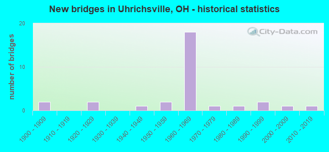
- New bridges - historical statistics
- 21900-1909
- 21920-1929
- 11940-1949
- 21950-1959
- 181960-1969
- 11970-1979
- 11980-1989
- 21990-1999
- 12000-2009
- 12010-2019

- Reconstructed bridges - Historical Statistics
- 31980-1989
- 01990-1999
- 42000-2009
- 32010-2019
- 12020-2022


- Bridge Condition - Deck
- 29.2%Excellent
- 16.7%Very good
- 12.5%Good
- 33.3%Satisfactory
- 4.2%Fair
- 4.2%Poor

- Bridge Condition - Superstructure
- 28.0%Excellent
- 16.0%Very good
- 24.0%Good
- 24.0%Satisfactory
- 4.0%Fair
- 4.0%Poor

- Bridge Condition - Substructure
- 32.0%Excellent
- 4.0%Very good
- 36.0%Good
- 24.0%Satisfactory
- 4.0%Fair

- Bridge Condition - Channel
- 25.0%Excellent
- 12.5%Very good
- 31.3%Good
- 25.0%Satisfactory
- 6.3%Fair
Find on map >> Show street view
Structure Number: 7900384, Location: 0.94 MI W OF JCT SR250 (Lat: 40.392981, Lng: -81.361200), Route carried "on" structure: Ramp US 36, Year Built: 1969, Year Reconstructed: 2020, Status: Open, Structure Length: 5.53m (18.14ft), Average Daily Traffic: 5,650 (year 2018), Truck Traffic: 12%, Average Future Daily Traffic: 6,020 (year 2038), Design Load: HS 20, Features Intersected: COL&OH R RR(TRENTON CONN
Minimum Vertical Clearance: 30+ m (98+ ft), Kilometerpoint: 27.745, Lanes on structure: 2, Owner: State Highway Agency, Approaching Roadway Width: 21.9m (71.9ft), Skew: 23 degrees, Material/Design: Steel continuous, Design/Construction: Stringer/Multi-beam, Number Of Spans In Main Unit: 3, Length of Maximum Span: 21.3m (69.9ft), Curb-To-Curb Width: 16.2m (53.1ft), Out-to-Out Width: 16.9m (55.4ft)
Condition: Deck: Excellent, Superstructure: Excellent, Substructure: Excellent, Operating Rating: 48.6 metric tons, Method Used To Determine Operating Rating: Load Factor (LF) rating reported by rating factor (RF) method using MS18 loading, Inventory Rating: 29.2 metric tons, Method Used To Determine Inventory Rating: Load Factor (LF) rating reported by rating factor (RF) method using MS18 loading, Structural Evaluation: Better than present minimum criteria, Deck Geometry: Superior to present desirable criteria, Underclear: Superior to present desirable criteria, Approach Roadway Alignment: Equal to present desirable criteria, Designated Inspection Frequency: Every 12 months, Inspection Date: August 2021, Deck Structure Type: Concrete Cast-file-Place, Wearing Surface/Protective System: Wearing Surface: Monolithic Concrete, Deck Protection: Epoxy Coated Reinforcing
Find on map >> Show street view
Structure Number: 7900392, Location: 0.94 MI W OF JCT SR250 (Lat: 40.395000, Lng: -81.362561), Route carried "on" structure: Ramp US 36, Year Built: 1969, Year Reconstructed: 2012, Status: Open, Structure Length: 7.37m (24.18ft), Average Daily Traffic: 3,400 (year 2011), Truck Traffic: 5%, Average Future Daily Traffic: 12,148 (year 2031), Design Load: HS 20+Mod, Features Intersected: US 36(TRENTON AVE CONN)
Minimum Vertical Clearance: 30+ m (98+ ft), Kilometerpoint: 27.745, Lanes on structure: 2, Lanes under structure: 5, Owner: State Highway Agency, Approaching Roadway Width: 18.9m (62.0ft), Skew: 20 degrees, Material/Design: Steel continuous, Design/Construction: Stringer/Multi-beam, Number Of Spans In Main Unit: 4, Length of Maximum Span: 24.4m (80.1ft), Curb-To-Curb Width: 14.2m (46.6ft), Out-to-Out Width: 15.1m (49.5ft)
Condition: Deck: Very good, Superstructure: Excellent, Substructure: Excellent, Operating Rating: 97.2 metric tons, Method Used To Determine Operating Rating: Load Factor (LF) rating reported by rating factor (RF) method using MS18 loading, Inventory Rating: 61.6 metric tons, Method Used To Determine Inventory Rating: Load Factor (LF) rating reported by rating factor (RF) method using MS18 loading, Structural Evaluation: Superior to present desirable criteria, Deck Geometry: Superior to present desirable criteria, Underclear: High priority of corrective action, Approach Roadway Alignment: Equal to present desirable criteria, Designated Inspection Frequency: Every 24 months, Inspection Date: September 2020, Deck Structure Type: Concrete Cast-file-Place, Wearing Surface/Protective System: Wearing Surface: Monolithic Concrete, Deck Protection: Epoxy Coated Reinforcing
Find on map >> Show street view
Structure Number: 7900422, Location: 0.18 MI W OF JCT US250 (Lat: 40.402439, Lng: -81.352989), Route carried "on" structure: Ramp US 36, Year Built: 1969, Status: Open, Structure Length: 5.46m (17.91ft), Average Daily Traffic: 7,250 (year 1973), Average Future Daily Traffic: 10,063 (year 1993), Design Load: H 20, Features Intersected: RAMP J OVER RJ CORMAN RR
Minimum Vertical Clearance: 30+ m (98+ ft), Kilometerpoint: 28.968, Lanes on structure: 1, Owner: State Highway Agency, Approaching Roadway Width: 10.4m (34.1ft), Skew: 3 degrees, Material/Design: Steel continuous, Design/Construction: Stringer/Multi-beam, Number Of Spans In Main Unit: 3, Length of Maximum Span: 20.4m (66.9ft), Curb or Sidewalk Widths: Left: 0.3m (1.0ft), Right: 0.3m (1.0ft), Curb-To-Curb Width: 7.8m (25.6ft), Out-to-Out Width: 9.2m (30.2ft)
Condition: Deck: Good, Superstructure: Good, Substructure: Good, Operating Rating: 42.1 metric tons, Method Used To Determine Operating Rating: Load Factor (LF) rating reported by rating factor (RF) method using MS18 loading, Inventory Rating: 32.4 metric tons, Method Used To Determine Inventory Rating: Load Factor (LF) rating reported by rating factor (RF) method using MS18 loading, Structural Evaluation: Better than present minimum criteria, Deck Geometry: Better than present minimum criteria, Underclear: Better than present minimum criteria, Approach Roadway Alignment: Equal to present desirable criteria, Designated Inspection Frequency: Every 24 months, Inspection Date: September 2020, Deck Structure Type: Concrete Cast-file-Place, Wearing Surface/Protective System: Wearing Surface: Integral Concrete
Find on map >> Show street view
Structure Number: 7900457, Location: 0.18 MI W OF JCT US250 (Lat: 40.403239, Lng: -81.352800), Route carried "on" structure: US 36, Year Built: 1969, Status: Open, Structure Length: 6.96m (22.83ft), Average Daily Traffic: 1,647 (year 2015), Truck Traffic: 11%, Average Future Daily Traffic: 2,286 (year 2035), Design Load: H 20, Features Intersected: RJ CORMAN RR
Minimum Vertical Clearance: 30+ m (98+ ft), Kilometerpoint: 28.968, Lanes on structure: 3, Owner: State Highway Agency, Approaching Roadway Width: 20.7m (67.9ft), Skew: 4 degrees, Material/Design: Steel continuous, Design/Construction: Stringer/Multi-beam, Number Of Spans In Main Unit: 3, Length of Maximum Span: 26.2m (86.0ft), Curb or Sidewalk Widths: Left: 0.3m (1.0ft), Right: 0.3m (1.0ft), Curb-To-Curb Width: 16.0m (52.5ft), Out-to-Out Width: 18.3m (60.0ft)
Condition: Deck: Good, Superstructure: Good, Substructure: Good, Operating Rating: 42.1 metric tons, Method Used To Determine Operating Rating: Allowable Stress (AS) rating reported by rating factor (RF) method using MS18 loading, Inventory Rating: 32.4 metric tons, Method Used To Determine Inventory Rating: Allowable Stress (AS) rating reported by rating factor (RF) method using MS18 loading, Structural Evaluation: Better than present minimum criteria, Deck Geometry: Equal to present minimum criteria, Underclear: Equal to present desirable criteria, Approach Roadway Alignment: Equal to present desirable criteria, Designated Inspection Frequency: Every 24 months, Inspection Date: September 2020, Deck Structure Type: Concrete Cast-file-Place, Wearing Surface/Protective System: Wearing Surface: Integral Concrete
Find on map >> Show street view
Structure Number: 7900481, Location: 0.18 MI W OF JCT US250 (Lat: 40.402950, Lng: -81.352831), Route carried "on" structure: US 36, Year Built: 1969, Status: Open, Structure Length: 6.96m (22.83ft), Average Daily Traffic: 1,647 (year 2015), Truck Traffic: 11%, Average Future Daily Traffic: 2,286 (year 2035), Design Load: H 20, Features Intersected: RJ CORMAN RR
Minimum Vertical Clearance: 30+ m (98+ ft), Kilometerpoint: 28.968, Lanes on structure: 2, Owner: State Highway Agency, Approaching Roadway Width: 13.4m (44.0ft), Skew: 4 degrees, Material/Design: Steel continuous, Design/Construction: Stringer/Multi-beam, Number Of Spans In Main Unit: 3, Length of Maximum Span: 26.2m (86.0ft), Curb or Sidewalk Widths: Left: 0.6m (2.0ft), Right: 0.6m (2.0ft), Curb-To-Curb Width: 9.1m (29.9ft), Out-to-Out Width: 11.2m (36.7ft)
Condition: Deck: Good, Superstructure: Good, Substructure: Good, Operating Rating: 42.1 metric tons, Method Used To Determine Operating Rating: Load Factor (LF) rating reported by rating factor (RF) method using MS18 loading, Inventory Rating: 32.4 metric tons, Method Used To Determine Inventory Rating: Load Factor (LF) rating reported by rating factor (RF) method using MS18 loading, Structural Evaluation: Better than present minimum criteria, Deck Geometry: Meets minimum limits, Underclear: Equal to present desirable criteria, Approach Roadway Alignment: Equal to present desirable criteria, Designated Inspection Frequency: Every 24 months, Inspection Date: September 2020, Deck Structure Type: Concrete Cast-file-Place, Wearing Surface/Protective System: Wearing Surface: Integral Concrete
Find on map >> Show street view
Structure Number: 7900511, Location: ON RAMP J AT JCT. US 250 (Lat: 40.402469, Lng: -81.349100), Route carried "on" structure: Ramp US 36, Year Built: 1969, Status: Open, Structure Length: 5.00m (16.40ft), Average Daily Traffic: 1,000 (year 1974), Average Future Daily Traffic: 1,388 (year 1994), Design Load: H 20, Features Intersected: BIG STILLWATER CR(RAMP J
Minimum Vertical Clearance: 30+ m (98+ ft), Kilometerpoint: 29.242, Lanes on structure: 2, Owner: State Highway Agency, Approaching Roadway Width: 12.8m (42.0ft), Material/Design: Concrete continuous, Design/Construction: Slab, Number Of Spans In Main Unit: 4, Length of Maximum Span: 13.7m (44.9ft), Curb or Sidewalk Widths: Left: 0.3m (1.0ft), Right: 0.3m (1.0ft), Curb-To-Curb Width: 10.3m (33.8ft), Out-to-Out Width: 11.7m (38.4ft)
Condition: Deck: Very good, Superstructure: Very good, Substructure: Very good, Channel: Very good, Operating Rating: 42.1 metric tons, Method Used To Determine Operating Rating: Load Factor (LF) rating reported by rating factor (RF) method using MS18 loading, Inventory Rating: 32.4 metric tons, Method Used To Determine Inventory Rating: Load Factor (LF) rating reported by rating factor (RF) method using MS18 loading, Structural Evaluation: Equal to present desirable criteria, Deck Geometry: Equal to present minimum criteria, Waterway Adequacy: Equal to present desirable criteria, Approach Roadway Alignment: Equal to present desirable criteria, Designated Inspection Frequency: Every 24 months, Inspection Date: August 2021, Deck Structure Type: Concrete Cast-file-Place, Wearing Surface/Protective System: Wearing Surface: Integral Concrete, Deck Protection: Cathodic Protection
Find on map >> Show street view
Structure Number: 7900546, Location: 7.72 MI. E. OF JCT. SR416 (Lat: 40.404511, Lng: -81.349431), Route carried "on" structure: Ramp US 250, Year Built: 1969, Status: Open, Structure Length: 6.80m (22.31ft), Average Daily Traffic: 11,500 (year 2021), Truck Traffic: 22%, Average Future Daily Traffic: 2,286 (year 2041), Design Load: HS 20, Features Intersected: US 250EB TO US 36WB
Minimum Vertical Clearance: 30+ m (98+ ft), Kilometerpoint: 35.148, Lanes on structure: 3, Lanes under structure: 5, Owner: State Highway Agency, Approaching Roadway Width: 16.8m (55.1ft), Material/Design: Concrete continuous, Design/Construction: Slab, Number Of Spans In Main Unit: 5, Length of Maximum Span: 14.6m (47.9ft), Curb or Sidewalk Widths: Left: 0.6m (2.0ft), Right: 0.6m (2.0ft), Curb-To-Curb Width: 14.8m (48.6ft), Out-to-Out Width: 16.9m (55.4ft)
Condition: Deck: Satisfactory, Superstructure: Satisfactory, Substructure: Satisfactory, Operating Rating: 42.1 metric tons, Method Used To Determine Operating Rating: Load Factor (LF) rating reported by rating factor (RF) method using MS18 loading, Inventory Rating: 32.4 metric tons, Method Used To Determine Inventory Rating: Load Factor (LF) rating reported by rating factor (RF) method using MS18 loading, Structural Evaluation: Equal to present minimum criteria, Deck Geometry: Equal to present desirable criteria, Underclear: High priority of corrective action, Approach Roadway Alignment: Equal to present desirable criteria, Designated Inspection Frequency: Every 12 months, Inspection Date: November 2021, Deck Structure Type: Concrete Cast-file-Place, Wearing Surface/Protective System: Wearing Surface: Latex Concrete
Find on map >> Show street view
Structure Number: 790057, Location: 7.72 MI. E. OF JCT SR416 (Lat: 40.404339, Lng: -81.349400), Route carried "on" structure: US 250, Year Built: 1969, Status: Open, Structure Length: 6.80m (22.31ft), Average Daily Traffic: 3,294 (year 2015), Truck Traffic: 12%, Average Future Daily Traffic: 4,572 (year 2035), Design Load: HS 20, Features Intersected: OVER US 250 EB LOOP RAMP
Minimum Vertical Clearance: 30+ m (98+ ft), Kilometerpoint: 35.599, Lanes on structure: 3, Lanes under structure: 5, Base Highway Network: Yes (Inventory Route: 2, Subroute: 1), Owner: State Highway Agency, Approaching Roadway Width: 16.2m (53.1ft), Material/Design: Concrete continuous, Design/Construction: Slab, Number Of Spans In Main Unit: 5, Length of Maximum Span: 14.6m (47.9ft), Curb or Sidewalk Widths: Left: 0.6m (2.0ft), Right: 0.6m (2.0ft), Curb-To-Curb Width: 14.7m (48.2ft), Out-to-Out Width: 16.8m (55.1ft)
Condition: Deck: Satisfactory, Superstructure: Satisfactory, Substructure: Good, Operating Rating: 42.1 metric tons, Method Used To Determine Operating Rating: Load Factor (LF) rating reported by rating factor (RF) method using MS18 loading, Inventory Rating: 32.4 metric tons, Method Used To Determine Inventory Rating: Load Factor (LF) rating reported by rating factor (RF) method using MS18 loading, Structural Evaluation: Equal to present minimum criteria, Deck Geometry: Meets minimum limits, Underclear: Meets minimum limits, Approach Roadway Alignment: Equal to present desirable criteria, Designated Inspection Frequency: Every 12 months, Inspection Date: November 2021, Deck Structure Type: Concrete Cast-file-Place, Wearing Surface/Protective System: Wearing Surface: Latex Concrete
Find on map >> Show street view
Structure Number: 79006, Location: 0.39 MI. E. OF JCT. US 36 (Lat: 40.404600, Lng: -81.341989), Route carried "on" structure: US 250, Year Built: 1969, Year Reconstructed: 2017, Status: Open, Structure Length: 8.69m (28.51ft), Average Daily Traffic: 12,000 (year 2017), Truck Traffic: 11%, Average Future Daily Traffic: 12,996 (year 2037), Design Load: HS 20+Mod, Features Intersected: STILLWATER CR AND CO RD6
Minimum Vertical Clearance: 30+ m (98+ ft), Kilometerpoint: 36.194, Lanes on structure: 2, Lanes under structure: 2, Base Highway Network: Yes (Inventory Route: 2, Subroute: 1), Owner: State Highway Agency, Approaching Roadway Width: 10.1m (33.1ft), Material/Design: Steel continuous, Design/Construction: Stringer/Multi-beam, Number Of Spans In Main Unit: 4, Length of Maximum Span: 24.4m (80.1ft), Curb-To-Curb Width: 10.1m (33.1ft), Out-to-Out Width: 11.1m (36.4ft)
Condition: Deck: Excellent, Superstructure: Excellent, Substructure: Good, Channel: Good, Operating Rating: 97.2 metric tons, Method Used To Determine Operating Rating: Load Factor (LF) rating reported by rating factor (RF) method using MS18 loading, Inventory Rating: 58.3 metric tons, Method Used To Determine Inventory Rating: Load Factor (LF) rating reported by rating factor (RF) method using MS18 loading, Structural Evaluation: Better than present minimum criteria, Deck Geometry: Meets minimum limits, Underclear: Somewhat better than minimum adequacy, Waterway Adequacy: Equal to present desirable criteria, Approach Roadway Alignment: Equal to present desirable criteria, Designated Inspection Frequency: Every 24 months, Underwater Inspection Frequency: Every 60 months, Inspection Date: March 2021, Underwater Inspection Date: July 2017, Deck Structure Type: Concrete Cast-file-Place, Wearing Surface/Protective System: Wearing Surface: Monolithic Concrete, Membrane: Other, Deck Protection: Epoxy Coated Reinforcing
Find on map >> Show street view
Structure Number: 7900635, Location: 0.39 MI. E. OF JCT. US 36 (Lat: 40.404431, Lng: -81.341981), Route carried "on" structure: US 250, Year Built: 1969, Year Reconstructed: 2017, Status: Open, Structure Length: 8.69m (28.51ft), Average Daily Traffic: 12,000 (year 2017), Truck Traffic: 11%, Average Future Daily Traffic: 12,996 (year 2037), Design Load: HS 20+Mod, Features Intersected: STILLWATER CR AND CO RD6
Minimum Vertical Clearance: 30+ m (98+ ft), Kilometerpoint: 36.194, Lanes on structure: 2, Lanes under structure: 2, Base Highway Network: Yes (Inventory Route: 2, Subroute: 1), Owner: State Highway Agency, Approaching Roadway Width: 10.1m (33.1ft), Material/Design: Steel continuous, Design/Construction: Stringer/Multi-beam, Number Of Spans In Main Unit: 4, Length of Maximum Span: 24.4m (80.1ft), Curb-To-Curb Width: 9.1m (29.9ft), Out-to-Out Width: 11.1m (36.4ft)
Condition: Deck: Excellent, Superstructure: Excellent, Substructure: Excellent, Channel: Excellent, Operating Rating: 97.2 metric tons, Method Used To Determine Operating Rating: Load Factor (LF) rating reported by rating factor (RF) method using MS18 loading, Inventory Rating: 58.3 metric tons, Method Used To Determine Inventory Rating: Load Factor (LF) rating reported by rating factor (RF) method using MS18 loading, Structural Evaluation: Superior to present desirable criteria, Deck Geometry: Meets minimum limits, Underclear: Somewhat better than minimum adequacy, Waterway Adequacy: Equal to present desirable criteria, Approach Roadway Alignment: Equal to present desirable criteria, Length Of Structure Improvement: 8.69m (28.51ft), Designated Inspection Frequency: Every 24 months, Underwater Inspection Frequency: Every 60 months, Inspection Date: March 2021, Underwater Inspection Date: July 2017, Roadway Improvement Cost: $21,000, Total Project Cost: $105,000, Deck Structure Type: Concrete Cast-file-Place, Wearing Surface/Protective System: Wearing Surface: Monolithic Concrete, Deck Protection: Epoxy Coated Reinforcing
Find on map >> Show street view
Structure Number: 7905378, Location: 1.51 MI. W. OF JCT. US36 (Lat: 40.423839, Lng: -81.359800), Route carried "on" structure: City street T0286, Year Built: 1967, Status: Open, Structure Length: 5.99m (19.65ft), Average Daily Traffic: 750 (year 1972), Truck Traffic: 10%, Average Future Daily Traffic: 24,649 (year 1992), Design Load: HL 93, Features Intersected: US 250--SR 800, Facility Carried by Structure: US 250
Minimum Vertical Clearance: 30+ m (98+ ft), Kilometerpoint: 5.166, Lanes on structure: 2, Lanes under structure: 4, Owner: State Highway Agency, Approaching Roadway Width: 8.5m (27.9ft), Material/Design: Steel continuous, Design/Construction: Stringer/Multi-beam, Number Of Spans In Main Unit: 4, Length of Maximum Span: 17.7m (58.1ft), Curb-To-Curb Width: 8.5m (27.9ft), Out-to-Out Width: 9.5m (31.2ft)
Condition: Deck: Excellent, Superstructure: Excellent, Substructure: Excellent, Operating Rating: 76.1 metric tons, Method Used To Determine Operating Rating: Load and Resistance Factor Rating (LRFR) rating reported by rating factor(RF) method using HL-93 loadings, Inventory Rating: 58.6 metric tons, Method Used To Determine Inventory Rating: Load and Resistance Factor Rating (LRFR) rating reported by rating factor(RF) method using HL-93 loadings, Structural Evaluation: Superior to present desirable criteria, Deck Geometry: Somewhat better than minimum adequacy, Underclear: High priority of corrective action, Approach Roadway Alignment: Equal to present desirable criteria, Designated Inspection Frequency: Every 12 months, Inspection Date: November 2021, Deck Structure Type: Concrete Cast-file-Place, Wearing Surface/Protective System: Wearing Surface: Monolithic Concrete, Deck Protection: Epoxy Coated Reinforcing
Find on map >> Show street view
Structure Number: 7905408, Location: WITHIN INTCH. US36&250 (Lat: 40.402939, Lng: -81.348700), Route carried "on" structure: Ramp US 250, Year Built: 1966, Year Reconstructed: 2006, Status: Open, Structure Length: 6.50m (21.33ft), Average Daily Traffic: 6,130 (year 1983), Truck Traffic: 2%, Average Future Daily Traffic: 8,508 (year 2003), Design Load: HS 20, Features Intersected: BIG STILLWATER CR
Minimum Vertical Clearance: 30+ m (98+ ft), Kilometerpoint: 35.196, Lanes on structure: 2, Owner: State Highway Agency, Approaching Roadway Width: 14.6m (47.9ft), Skew: 23 degrees, Material/Design: Steel continuous, Design/Construction: Stringer/Multi-beam, Number Of Spans In Main Unit: 3, Length of Maximum Span: 24.4m (80.1ft), Curb or Sidewalk Widths: Left: 1.8m (5.9ft), Right: 1.8m (5.9ft), Curb-To-Curb Width: 10.2m (33.5ft), Out-to-Out Width: 12.5m (41.0ft)
Condition: Deck: Very good, Superstructure: Very good, Substructure: Good, Channel: Good, Operating Rating: 42.1 metric tons, Method Used To Determine Operating Rating: Load Factor (LF) rating reported by rating factor (RF) method using MS18 loading, Inventory Rating: 32.4 metric tons, Method Used To Determine Inventory Rating: Load Factor (LF) rating reported by rating factor (RF) method using MS18 loading, Structural Evaluation: Better than present minimum criteria, Deck Geometry: Equal to present minimum criteria, Waterway Adequacy: Equal to present desirable criteria, Approach Roadway Alignment: Equal to present desirable criteria, Length Of Structure Improvement: 9.48m (31.10ft), Designated Inspection Frequency: Every 24 months, Underwater Inspection Frequency: Every 60 months, Inspection Date: November 2021, Underwater Inspection Date: July 2017, Bridge Improvement Cost: $475,000, Roadway Improvement Cost: $95,000, Total Project Cost: $587,000, Deck Structure Type: Concrete Cast-file-Place, Wearing Surface/Protective System: Wearing Surface: Monolithic Concrete, Deck Protection: Epoxy Coated Reinforcing
Find on map >> Show street view
Structure Number: 7905432, Location: WITHIN INTCH.US36&250 (Lat: 40.402839, Lng: -81.348850), Route carried "on" structure: Ramp County highway 610, Year Built: 1952, Year Reconstructed: 2006, Status: Open, Structure Length: 6.50m (21.33ft), Average Daily Traffic: 6,130 (year 1983), Truck Traffic: 3%, Average Future Daily Traffic: 8,508 (year 2003), Design Load: HS 20, Features Intersected: BIG STILLWATER CR, Facility Carried by Structure: RAMP US36 TO US250
Minimum Vertical Clearance: 30+ m (98+ ft), Kilometerpoint: 35.196, Lanes on structure: 2, Owner: State Highway Agency, Approaching Roadway Width: 14.6m (47.9ft), Skew: 3 degrees, Material/Design: Steel continuous, Design/Construction: Stringer/Multi-beam, Number Of Spans In Main Unit: 3, Length of Maximum Span: 24.4m (80.1ft), Curb or Sidewalk Widths: Left: 0.0m, Right: 1.8m (5.9ft), Curb-To-Curb Width: 9.8m (32.2ft), Out-to-Out Width: 13.6m (44.6ft)
Condition: Deck: Very good, Superstructure: Good, Substructure: Satisfactory, Channel: Good, Operating Rating: 42.1 metric tons, Method Used To Determine Operating Rating: Load Factor (LF) rating reported by rating factor (RF) method using MS18 loading, Inventory Rating: 32.4 metric tons, Method Used To Determine Inventory Rating: Load Factor (LF) rating reported by rating factor (RF) method using MS18 loading, Structural Evaluation: Equal to present minimum criteria, Deck Geometry: Equal to present minimum criteria, Waterway Adequacy: Equal to present desirable criteria, Approach Roadway Alignment: Equal to present desirable criteria, Length Of Structure Improvement: 9.48m (31.10ft), Designated Inspection Frequency: Every 12 months, Underwater Inspection Frequency: Every 60 months, Inspection Date: November 2021, Underwater Inspection Date: July 2017, Bridge Improvement Cost: $475,000, Roadway Improvement Cost: $95,000, Total Project Cost: $587,000, Deck Structure Type: Concrete Cast-file-Place, Wearing Surface/Protective System: Wearing Surface: Monolithic Concrete, Deck Protection: Epoxy Coated Reinforcing
Find on map >> Show street view
Structure Number: 7931263, Location: 0.1 MI SW OF NEWPORT (Lat: 40.357489, Lng: -81.343539), Route carried "on" structure: County highway C0028, Year Built: 2009, Status: Open, Structure Length: 0.91m (2.99ft), Average Daily Traffic: 1,600 (year 2015), Truck Traffic: 4%, Average Future Daily Traffic: 2,221 (year 2035), Design Load: HS 20+Mod, Features Intersected: BRANCH OF STILLWATER CK, Facility Carried by Structure: MILL TWP CR 28
Minimum Vertical Clearance: 30+ m (98+ ft), Kilometerpoint: 0.756, Lanes on structure: 2, Owner: County Highway Agency, Approaching Roadway Width: 6.2m (20.3ft), Material/Design: Concrete, Design/Construction: Box Beam or Girders - Multiple, Number Of Spans In Main Unit: 1, Length of Maximum Span: 8.7m (28.5ft), Curb-To-Curb Width: 9.1m (29.9ft), Out-to-Out Width: 9.1m (29.9ft)
Condition: Deck: Excellent, Superstructure: Excellent, Substructure: Excellent, Channel: Excellent, Operating Rating: 94.0 metric tons, Method Used To Determine Operating Rating: Load and Resistance Factor Rating (LRFR) rating reported by rating factor(RF) method using HL-93 loadings, Inventory Rating: 55.1 metric tons, Method Used To Determine Inventory Rating: Load and Resistance Factor Rating (LRFR) rating reported by rating factor(RF) method using HL-93 loadings, Structural Evaluation: Superior to present desirable criteria, Deck Geometry: Somewhat better than minimum adequacy, Waterway Adequacy: Superior to present desirable criteria, Approach Roadway Alignment: Better than present minimum criteria, Designated Inspection Frequency: Every 24 months, Inspection Date: January 2021, Deck Structure Type: Concrete Cast-file-Place, Wearing Surface/Protective System: Wearing Surface: Bituminous, Membrane: Preformed Fabric
Find on map >> Show street view
Structure Number: 7931352, Location: 02 MI SE OF SR250 JCT (Lat: 40.426189, Lng: -81.365719), Route carried "on" structure: County highway C0062, Year Built: 1958, Year Reconstructed: 2015, Status: Open, Structure Length: 6.46m (21.19ft), Average Daily Traffic: 4,798 (year 2015), Truck Traffic: 7%, Average Future Daily Traffic: 6,660 (year 2035), Design Load: HS 20+Mod, Features Intersected: STILLWATER CREEK, Facility Carried by Structure: MILL TWP CR 62
Minimum Vertical Clearance: 30+ m (98+ ft), Kilometerpoint: 1.271, Lanes on structure: 2, Owner: County Highway Agency, Approaching Roadway Width: 10.4m (34.1ft), Skew: 2 degrees, Material/Design: Steel continuous, Design/Construction: Stringer/Multi-beam, Number Of Spans In Main Unit: 3, Length of Maximum Span: 24.4m (80.1ft), Curb-To-Curb Width: 10.4m (34.1ft), Out-to-Out Width: 10.4m (34.1ft)
Condition: Deck: Excellent, Superstructure: Very good, Substructure: Good, Channel: Satisfactory, Operating Rating: 68.0 metric tons, Method Used To Determine Operating Rating: Allowable Stress (AS) rating reported by rating factor (RF) method using MS18 loading, Inventory Rating: 38.9 metric tons, Method Used To Determine Inventory Rating: Allowable Stress (AS) rating reported by rating factor (RF) method using MS18 loading, Structural Evaluation: Better than present minimum criteria, Deck Geometry: Somewhat better than minimum adequacy, Waterway Adequacy: Equal to present minimum criteria, Approach Roadway Alignment: Equal to present desirable criteria, Length Of Structure Improvement: 8.01m (26.28ft), Designated Inspection Frequency: Every 24 months, Underwater Inspection Frequency: Every 60 months, Inspection Date: May 2021, Underwater Inspection Date: March 2017, Bridge Improvement Cost: $596,278,000, Roadway Improvement Cost: $5,000,000, Total Project Cost: $70,000,000, Deck Structure Type: Concrete Cast-file-Place, Wearing Surface/Protective System: Wearing Surface: Monolithic Concrete, Deck Protection: Epoxy Coated Reinforcing
Find on map >> Show street view
Structure Number: 7931425, Location: 1 MI. SE OF CO RD 34 JCT. (Lat: 40.348331, Lng: -81.337211), Route carried "on" structure: County highway T0292, Year Built: 1992, Status: Open, Structure Length: 3.66m (12.01ft), Average Daily Traffic: 113 (year 2015), Truck Traffic: 8%, Average Future Daily Traffic: 157 (year 2035), Design Load: HS 20, Features Intersected: BIG STILLWATER CREEK, Facility Carried by Structure: MILL TWP. RD. 292
Minimum Vertical Clearance: 30+ m (98+ ft), Kilometerpoint: 0.982, Lanes on structure: 2, Owner: County Highway Agency, Approaching Roadway Width: 7.9m (25.9ft), Material/Design: Steel, Design/Construction: Truss - Thru, Number Of Spans In Main Unit: 1, Length of Maximum Span: 35.4m (116.1ft), Curb-To-Curb Width: 6.1m (20.0ft), Out-to-Out Width: 6.2m (20.3ft)
Condition: Deck: Satisfactory, Superstructure: Good, Substructure: Excellent, Channel: Excellent, Operating Rating: 81.0 metric tons, Method Used To Determine Operating Rating: Allowable Stress (AS) rating reported by rating factor (RF) method using MS18 loading, Inventory Rating: 77.8 metric tons, Method Used To Determine Inventory Rating: Allowable Stress (AS) rating reported by rating factor (RF) method using MS18 loading, Structural Evaluation: Better than present minimum criteria, Deck Geometry: Meets minimum limits, Waterway Adequacy: Equal to present desirable criteria, Approach Roadway Alignment: Equal to present minimum criteria, Designated Inspection Frequency: Every 12 months, Critical Feature Inspection Frequency: Every 24 months, Inspection Date: January 2021, Critical Feature Inspection Date: January 2021, Deck Structure Type: Corrugated Steel, Wearing Surface/Protective System: Wearing Surface: Bituminous, Membrane: Preformed Fabric
Find on map >> Show street view
Structure Number: 793169, Location: 0.3 MI NE OF CR 28 (Lat: 40.360600, Lng: -81.340619), Route carried "on" structure: County highway C0037, Year Built: 2015, Status: Open, Structure Length: 4.79m (15.72ft), Average Daily Traffic: 123 (year 2015), Truck Traffic: 5%, Average Future Daily Traffic: 171 (year 2035), Design Load: HL 93, Features Intersected: STILLWATER CREEK, Facility Carried by Structure: MILL TWP CR 37
Minimum Vertical Clearance: 30+ m (98+ ft), Kilometerpoint: 0.966, Lanes on structure: 2, Owner: County Highway Agency, Approaching Roadway Width: 10.4m (34.1ft), Material/Design: Steel continuous, Design/Construction: Stringer/Multi-beam, Number Of Spans In Main Unit: 3, Length of Maximum Span: 21.5m (70.5ft), Curb-To-Curb Width: 9.8m (32.2ft), Out-to-Out Width: 9.8m (32.2ft)
Condition: Deck: Excellent, Superstructure: Excellent, Substructure: Excellent, Channel: Excellent, Operating Rating: 42.1 metric tons, Method Used To Determine Operating Rating: Load and Resistance Factor Rating (LRFR) rating reported by rating factor(RF) method using HL-93 loadings, Inventory Rating: 32.4 metric tons, Method Used To Determine Inventory Rating: Load and Resistance Factor Rating (LRFR) rating reported by rating factor(RF) method using HL-93 loadings, Structural Evaluation: Equal to present desirable criteria, Deck Geometry: Better than present minimum criteria, Waterway Adequacy: Superior to present desirable criteria, Approach Roadway Alignment: Equal to present desirable criteria, Designated Inspection Frequency: Every 24 months, Inspection Date: May 2021, Deck Structure Type: Concrete Cast-file-Place, Wearing Surface/Protective System: Wearing Surface: Monolithic Concrete, Deck Protection: Epoxy Coated Reinforcing
Find on map >> Show street view
Structure Number: 7937091, Location: 500 FT S.W. OF JCT CR-64 (Lat: 40.426750, Lng: -81.355661), Route carried "on" structure: City street JOHDR, Year Built: 1999, Status: Open, Structure Length: 5.30m (17.39ft), Average Daily Traffic: 1,619 (year 2015), Truck Traffic: 5%, Average Future Daily Traffic: 2,247 (year 2035), Design Load: HS 20+Mod, Features Intersected: STILLWATER CREEK, Facility Carried by Structure: JOHNSON DRIVE
Minimum Vertical Clearance: 30+ m (98+ ft), Kilometerpoint: 8.288, Lanes on structure: 2, Owner: County Highway Agency, Approaching Roadway Width: 7.6m (24.9ft), Material/Design: Prestressed concrete, Design/Construction: Box Beam or Girders - Multiple, Number Of Spans In Main Unit: 3, Length of Maximum Span: 30.5m (100.1ft), Curb-To-Curb Width: 8.5m (27.9ft), Out-to-Out Width: 8.5m (27.9ft)
Condition: Deck: Satisfactory, Superstructure: Good, Substructure: Excellent, Channel: Very good, Operating Rating: 42.1 metric tons, Method Used To Determine Operating Rating: Load and Resistance Factor Rating (LRFR) rating reported by rating factor(RF) method using HL-93 loadings, Inventory Rating: 32.4 metric tons, Method Used To Determine Inventory Rating: Load and Resistance Factor Rating (LRFR) rating reported by rating factor(RF) method using HL-93 loadings, Structural Evaluation: Better than present minimum criteria, Deck Geometry: Somewhat better than minimum adequacy, Waterway Adequacy: Superior to present desirable criteria, Approach Roadway Alignment: Better than present minimum criteria, Designated Inspection Frequency: Every 12 months, Inspection Date: May 2021, Deck Structure Type: Concrete Cast-file-Place, Wearing Surface/Protective System: Wearing Surface: Bituminous, Membrane: Preformed Fabric
Find on map >> Show street view
Structure Number: 7937199, Location: 0.1 MI SW OF CO RD 64 JCT (Lat: 40.402919, Lng: -81.339861), Route carried "on" structure: City street EASAV, Year Built: 1925, Year Reconstructed: 1992, Status: Open, Structure Length: 2.38m (7.81ft), Average Daily Traffic: 1,340 (year 2015), Truck Traffic: 5%, Average Future Daily Traffic: 1,860 (year 2035), Features Intersected: LITTLE STILLWATER CREEK, Facility Carried by Structure: EASTPORT AVENUE
Minimum Vertical Clearance: 30+ m (98+ ft), Kilometerpoint: 8.320, Lanes on structure: 2, Owner: County Highway Agency, Approaching Roadway Width: 9.1m (29.9ft), Material/Design: Concrete, Design/Construction: Arch - Deck, Number Of Spans In Main Unit: 1, Length of Maximum Span: 21.3m (69.9ft), Curb-To-Curb Width: 8.7m (28.5ft), Out-to-Out Width: 9.6m (31.5ft)
Condition: Superstructure: Satisfactory, Substructure: Satisfactory, Channel: Satisfactory, Operating Rating: 84.2 metric tons, Method Used To Determine Operating Rating: Allowable Stress (AS) rating reported by rating factor (RF) method using MS18 loading, Inventory Rating: 68.0 metric tons, Method Used To Determine Inventory Rating: Allowable Stress (AS) rating reported by rating factor (RF) method using MS18 loading, Structural Evaluation: Equal to present minimum criteria, Deck Geometry: Somewhat better than minimum adequacy, Waterway Adequacy: Better than present minimum criteria, Approach Roadway Alignment: Equal to present minimum criteria, Length Of Structure Improvement: 2.38m (7.81ft), Designated Inspection Frequency: Every 12 months, Inspection Date: May 2021, Bridge Improvement Cost: $15,000, Roadway Improvement Cost: $2,000, Total Project Cost: $20,000, Wearing Surface/Protective System: Wearing Surface: Bituminous
Find on map >> Show street view
Structure Number: 7937369, Location: 1.2 MI S OF SR 36 & SR250 (Lat: 40.388100, Lng: -81.347111), Route carried "on" structure: City street TREAV, Year Built: 1928, Year Reconstructed: 1992, Status: Open, Structure Length: 4.18m (13.71ft), Average Daily Traffic: 3,871 (year 2015), Truck Traffic: 5%, Average Future Daily Traffic: 5,373 (year 2035), Features Intersected: BIG STILLWATER CREEK, Facility Carried by Structure: TRENTON AVE
Minimum Vertical Clearance: 30+ m (98+ ft), Kilometerpoint: 8.304, Lanes on structure: 2, Owner: City or Municipal Highway Agency, Approaching Roadway Width: 9.1m (29.9ft), Material/Design: Concrete, Design/Construction: Tee Beam, Number Of Spans In Main Unit: 3, Length of Maximum Span: 12.8m (42.0ft), Curb or Sidewalk Widths: Left: 1.5m (4.9ft), Right: 1.5m (4.9ft), Curb-To-Curb Width: 9.1m (29.9ft), Out-to-Out Width: 13.1m (43.0ft)
Condition: Deck: Satisfactory, Superstructure: Satisfactory, Substructure: Fair, Channel: Satisfactory, Operating Rating: 48.6 metric tons, Method Used To Determine Operating Rating: Load Factor (LF) rating reported by rating factor (RF) method using MS18 loading, Inventory Rating: 29.2 metric tons, Method Used To Determine Inventory Rating: Load Factor (LF) rating reported by rating factor (RF) method using MS18 loading, Structural Evaluation: Somewhat better than minimum adequacy, Deck Geometry: Meets minimum limits, Waterway Adequacy: Equal to present desirable criteria, Approach Roadway Alignment: Equal to present desirable criteria, Length Of Structure Improvement: 4.18m (13.71ft), Designated Inspection Frequency: Every 12 months, Inspection Date: August 2021, Bridge Improvement Cost: $130,000, Roadway Improvement Cost: $13,000, Total Project Cost: $150,000, Deck Structure Type: Concrete Cast-file-Place, Wearing Surface/Protective System: Wearing Surface: Bituminous
Find on map >> Show street view
Structure Number: 793752, Location: UHRICHSVILLE E CORP LINE (Lat: 40.393119, Lng: -81.338350), Route carried "on" structure: City street 4TH, Year Built: 1908, Status: Open, Structure Length: 3.90m (12.80ft), Average Daily Traffic: 2,453 (year 2015), Truck Traffic: 7%, Average Future Daily Traffic: 3,405 (year 2035), Features Intersected: LITTLE STILLWATER CREEK
Minimum Vertical Clearance: 30+ m (98+ ft), Kilometerpoint: 8.336, Lanes on structure: 2, Owner: City or Municipal Highway Agency, Approaching Roadway Width: 12.2m (40.0ft), Material/Design: Concrete, Design/Construction: Arch - Deck, Number Of Spans In Main Unit: 2, Length of Maximum Span: 15.2m (49.9ft), Curb or Sidewalk Widths: Left: 2.1m (6.9ft), Right: 2.1m (6.9ft), Curb-To-Curb Width: 12.3m (40.4ft), Out-to-Out Width: 17.8m (58.4ft)
Condition: Deck: Fair, Superstructure: Fair, Substructure: Satisfactory, Channel: Good, Operating Rating: 32.4 metric tons, Method Used To Determine Operating Rating: Load Factor (LF) rating reported by rating factor (RF) method using MS18 loading, Inventory Rating: 19.4 metric tons, Method Used To Determine Inventory Rating: Load Factor (LF) rating reported by rating factor (RF) method using MS18 loading, Structural Evaluation: Somewhat better than minimum adequacy, Deck Geometry: Equal to present minimum criteria, Waterway Adequacy: Better than present minimum criteria, Approach Roadway Alignment: Equal to present desirable criteria, Designated Inspection Frequency: Every 12 months, Inspection Date: June 2021, Wearing Surface/Protective System: Wearing Surface: Bituminous
Find on map >> Show street view
Structure Number: 7937695, Location: UHRICHSVILLE E CORP LINE (Lat: 40.392419, Lng: -81.338100), Route carried "on" structure: City street CNTR, Year Built: 1903, Year Reconstructed: 2009, Status: Open, Structure Length: 4.39m (14.40ft), Average Daily Traffic: 1,743 (year 2015), Truck Traffic: 5%, Average Future Daily Traffic: 2,419 (year 2035), Features Intersected: LITTLE STILLWATER CREEK, Facility Carried by Structure: CENTER ST&DENN COR
Minimum Vertical Clearance: 30+ m (98+ ft), Kilometerpoint: 8.497, Lanes on structure: 2, Owner: City or Municipal Highway Agency, Approaching Roadway Width: 7.3m (24.0ft), Material/Design: Masonry, Design/Construction: Arch - Deck, Number Of Spans In Main Unit: 2, Length of Maximum Span: 11.9m (39.0ft), Curb or Sidewalk Widths: Left: 1.2m (3.9ft), Right: 0.6m (2.0ft), Curb-To-Curb Width: 7.3m (24.0ft), Out-to-Out Width: 9.8m (32.2ft)
Condition: Deck: Satisfactory, Superstructure: Satisfactory, Substructure: Good, Channel: Fair, Operating Rating: 64.8 metric tons, Method Used To Determine Operating Rating: Load Factor (LF) rating reported by rating factor (RF) method using MS18 loading, Inventory Rating: 38.9 metric tons, Method Used To Determine Inventory Rating: Load Factor (LF) rating reported by rating factor (RF) method using MS18 loading, Structural Evaluation: Equal to present minimum criteria, Deck Geometry: Meets minimum limits, Waterway Adequacy: Better than present minimum criteria, Approach Roadway Alignment: Better than present minimum criteria, Designated Inspection Frequency: Every 12 months, Inspection Date: August 2021, Deck Structure Type: Other, Wearing Surface/Protective System: Wearing Surface: Integral Concrete
Find on map >> Show street view
Structure Number: 7937857, Location: UHRICHSVILLE CORP LINE (Lat: 40.390500, Lng: -81.335769), Route carried "on" structure: County highway 604, Year Built: 1941, Year Reconstructed: 1989, Status: Open, Structure Length: 3.11m (10.20ft), Average Daily Traffic: 1,957 (year 2015), Truck Traffic: 5%, Average Future Daily Traffic: 2,716 (year 2035), Design Load: HS 20+Mod, Features Intersected: LITTLE STILLWATER CREEK, Facility Carried by Structure: 1ST ST & DENN CORP
Minimum Vertical Clearance: 30+ m (98+ ft), Kilometerpoint: 8.481, Lanes on structure: 2, Owner: City or Municipal Highway Agency, Approaching Roadway Width: 7.3m (24.0ft), Material/Design: Steel, Design/Construction: Truss - Thru, Number Of Spans In Main Unit: 1, Length of Maximum Span: 29.9m (98.1ft), Curb or Sidewalk Widths: Left: 1.5m (4.9ft), Right: 1.5m (4.9ft), Curb-To-Curb Width: 7.3m (24.0ft), Out-to-Out Width: 8.2m (26.9ft)
Condition: Deck: Satisfactory, Superstructure: Satisfactory, Substructure: Satisfactory, Channel: Satisfactory, Operating Rating: 42.1 metric tons, Method Used To Determine Operating Rating: Load Factor (LF) rating reported by rating factor (RF) method using MS18 loading, Inventory Rating: 22.7 metric tons, Method Used To Determine Inventory Rating: Load Factor (LF) rating reported by rating factor (RF) method using MS18 loading, Structural Evaluation: Equal to present minimum criteria, Deck Geometry: Meets minimum limits, Waterway Adequacy: Equal to present desirable criteria, Approach Roadway Alignment: Equal to present desirable criteria, Designated Inspection Frequency: Every 12 months, Critical Feature Inspection Frequency: Every 24 months, Inspection Date: August 2021, Critical Feature Inspection Date: August 2020, Deck Structure Type: Corrugated Steel, Wearing Surface/Protective System: Wearing Surface: Bituminous, Membrane: Preformed Fabric
Find on map >> Show street view
Structure Number: 7960395, Location: 0.8 MI S OF SR 36 & SR250 (Lat: 40.392400, Lng: -81.346681), Route carried "on" structure: City street WATER, Year Built: 1975, Status: Open, Structure Length: 4.88m (16.01ft), Average Daily Traffic: 5,471 (year 2015), Truck Traffic: 5%, Average Future Daily Traffic: 7,594 (year 2035), Design Load: HS 20+Mod, Features Intersected: OHIO CENTRAL RAILROAD
Minimum Vertical Clearance: 30+ m (98+ ft), Kilometerpoint: 8.465, Lanes on structure: 2, Owner: City or Municipal Highway Agency, Approaching Roadway Width: 9.1m (29.9ft), Skew: 1 degrees, Material/Design: Steel continuous, Design/Construction: Stringer/Multi-beam, Number Of Spans In Main Unit: 3, Length of Maximum Span: 18.9m (62.0ft), Curb or Sidewalk Widths: Left: 1.5m (4.9ft), Right: 1.5m (4.9ft), Curb-To-Curb Width: 9.1m (29.9ft), Out-to-Out Width: 12.9m (42.3ft)
Condition: Deck: Satisfactory, Superstructure: Very good, Substructure: Satisfactory, Operating Rating: 58.3 metric tons, Method Used To Determine Operating Rating: Load Factor (LF) rating reported by rating factor (RF) method using MS18 loading, Inventory Rating: 35.6 metric tons, Method Used To Determine Inventory Rating: Load Factor (LF) rating reported by rating factor (RF) method using MS18 loading, Structural Evaluation: Equal to present minimum criteria, Deck Geometry: High priority of corrective action, Underclear: High priority of corrective action, Approach Roadway Alignment: Superior to present desirable criteria, Designated Inspection Frequency: Every 12 months, Inspection Date: August 2021, Deck Structure Type: Concrete Cast-file-Place, Wearing Surface/Protective System: Wearing Surface: Integral Concrete, Deck Protection: Epoxy Coated Reinforcing
Find on map >> Show street view
Structure Number: 7961324, Location: UHRICHSVILLE DOWNTOWN (Lat: 40.390969, Lng: -81.347331), Route carried "on" structure: City street W3RD, Year Built: 1985, Status: Open, Structure Length: 3.35m (10.99ft), Average Daily Traffic: 1,022 (year 2015), Truck Traffic: 5%, Average Future Daily Traffic: 1,419 (year 2035), Design Load: HS 20+Mod, Features Intersected: BIG STILLWATER CREEK, Facility Carried by Structure: WEST 3RD STREET
Minimum Vertical Clearance: 30+ m (98+ ft), Kilometerpoint: 8.449, Lanes on structure: 2, Owner: City or Municipal Highway Agency, Approaching Roadway Width: 9.1m (29.9ft), Skew: 1 degrees, Material/Design: Prestressed concrete, Design/Construction: Box Beam or Girders - Multiple, Number Of Spans In Main Unit: 1, Length of Maximum Span: 33.2m (108.9ft), Curb or Sidewalk Widths: Left: 1.5m (4.9ft), Right: 1.5m (4.9ft), Curb-To-Curb Width: 9.1m (29.9ft), Out-to-Out Width: 12.8m (42.0ft)
Condition: Deck: Poor, Superstructure: Poor, Substructure: Good, Channel: Good, Operating Rating: 38.9 metric tons, Method Used To Determine Operating Rating: Load and Resistance Factor Rating (LRFR) rating reported by rating factor(RF) method using HL-93 loadings, Inventory Rating: 9.7 metric tons, Method Used To Determine Inventory Rating: Load and Resistance Factor Rating (LRFR) rating reported by rating factor(RF) method using HL-93 loadings, Structural Evaluation: High priority of corrective action, Deck Geometry: Somewhat better than minimum adequacy, Waterway Adequacy: Better than present minimum criteria, Approach Roadway Alignment: Superior to present desirable criteria, Designated Inspection Frequency: Every 12 months, Inspection Date: August 2021, Deck Structure Type: Other, Wearing Surface/Protective System: Wearing Surface: Bituminous
Find on map >> Show street view
Structure Number: 7900392, Location: 0.94 MI W OF JCT SR250 (Lat: 40.395000, Lng: -81.362561), Route carried "under" structure: US 36, Year Built: 1969, Structure Length: 0. m, Average Daily Traffic: 8,752 (year 2015), Truck Traffic: 12%, Features Intersected: TRENTON AVE CONNCTOR(SUB
Minimum Vertical Clearance: 4.75m (15.58ft), Kilometerpoint: 27.745, Lanes on structure: 2, Lanes under structure: 5, Material/Design: Steel continuous, Design/Construction: Stringer/Multi-beam, Length of Maximum Span: 24.4m (80.1ft)
Find on map >> Show street view
Structure Number: 7900546, Location: 7.72 MI. E. OF JCT. SR416 (Lat: 40.404511, Lng: -81.349431), Route carried "under" structure: US 250, Year Built: 1969, Structure Length: 0. m, Average Daily Traffic: 1,647 (year 2015), Truck Traffic: 13%, Features Intersected: CONNECTOR OVER US 250EB
Minimum Vertical Clearance: 5.64m (18.50ft), Kilometerpoint: 35.148, Lanes on structure: 3, Lanes under structure: 5, Material/Design: Concrete continuous, Design/Construction: Slab, Length of Maximum Span: 14.6m (47.9ft)
Find on map >> Show street view
Structure Number: 790057, Location: 7.72 MI. E. OF JCT SR416 (Lat: 40.404339, Lng: -81.349400), Route carried "under" structure: US 250, Year Built: 1969, Structure Length: 0. m, Average Daily Traffic: 2,358 (year 2015), Truck Traffic: 12%, Features Intersected: US 250
Minimum Vertical Clearance: 4.90m (16.08ft), Kilometerpoint: 35.180, Lanes on structure: 3, Lanes under structure: 5, Material/Design: Concrete continuous, Design/Construction: Slab, Length of Maximum Span: 14.6m (47.9ft)
Find on map >> Show street view
Structure Number: 79006, Location: 0.39 MI. E. OF JCT. US 36 (Lat: 40.404600, Lng: -81.341989), Route carried "under" structure: County highway 16, Year Built: 1969, Structure Length: 0. m, Average Daily Traffic: 1,038 (year 2015), Truck Traffic: 5%, Features Intersected: US 36--US 250, Facility Carried by Structure: US. 250 & SR 800
Minimum Vertical Clearance: 4.42m (14.50ft), Kilometerpoint: 2.607, Lanes on structure: 2, Lanes under structure: 2, Material/Design: Steel continuous, Design/Construction: Stringer/Multi-beam, Length of Maximum Span: 24.4m (80.1ft)
Find on map >> Show street view
Structure Number: 7900635, Location: 0.39 MI. E. OF JCT. US 36 (Lat: 40.404431, Lng: -81.341981), Route carried "under" structure: County highway 64, Year Built: 1969, Structure Length: 0. m, Average Daily Traffic: 1,038 (year 2015), Truck Traffic: 5%, Features Intersected: US 36--US 250, Facility Carried by Structure: US 250 & SR 800
Minimum Vertical Clearance: 4.42m (14.50ft), Kilometerpoint: 2.607, Lanes on structure: 2, Lanes under structure: 2, Material/Design: Steel continuous, Design/Construction: Stringer/Multi-beam, Length of Maximum Span: 24.4m (80.1ft)
Find on map >> Show street view
Structure Number: 7905378, Location: 1.51 MI. W. OF JCT. US36 (Lat: 40.423839, Lng: -81.359800), Route carried "under" structure: US 250, Year Built: 1967, Structure Length: 0. m, Average Daily Traffic: 17,759 (year 2015), Truck Traffic: 12%, Features Intersected: TWP RD 286
Minimum Vertical Clearance: 4.67m (15.32ft), Kilometerpoint: 32.718, Lanes on structure: 2, Lanes under structure: 4, Material/Design: Steel continuous, Design/Construction: Stringer/Multi-beam, Length of Maximum Span: 17.7m (58.1ft)